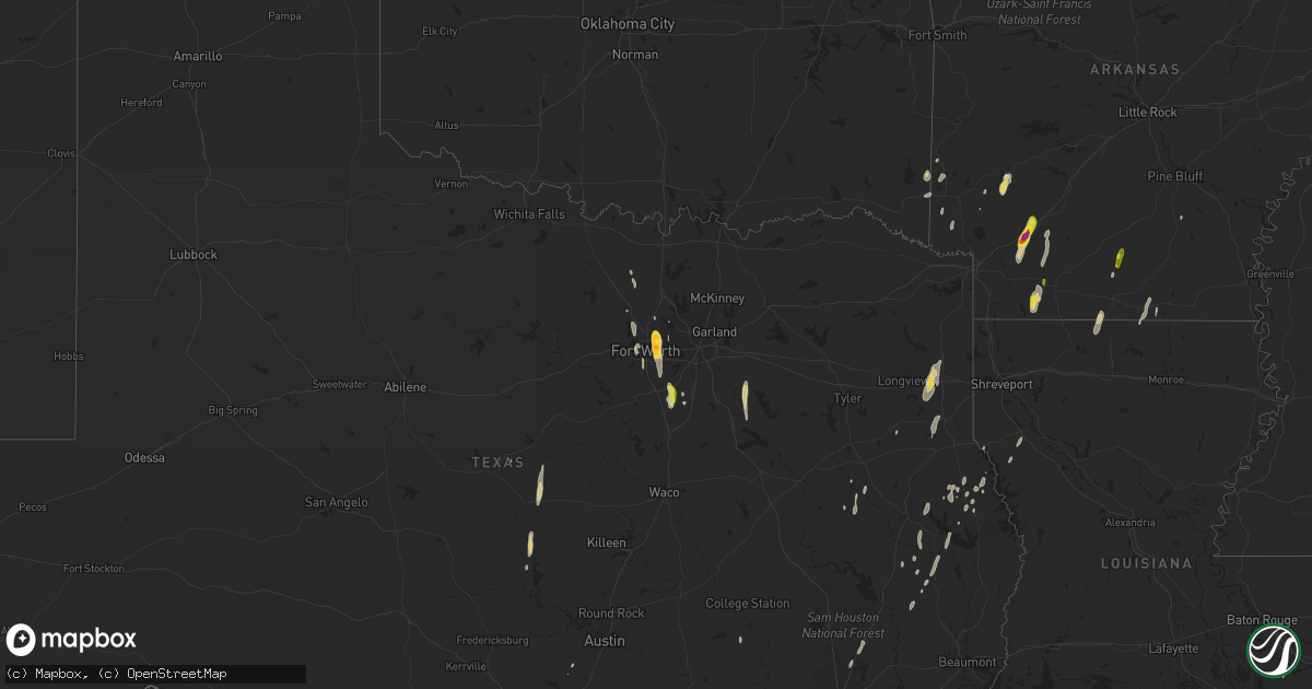
Hail Map on December 27, 2015
Get this storm
December 27 map
$229
one time, instant access
Download today. No call, no setup
Keep the $229
Bought the map and want the full workflow? Apply the entire $229 to a subscription within 7 days. None of it is wasted.
Every map, not just this one
This buys you this map. Subscription and you get every map we run, in the markets you choose from a few cities to whole states to nationwide. Plus real-time alerts the moment a storm fires.
Contact data
Name, contact info, occupancy, even credit band for addresses in the footprint. You go from where it hit to who to call.
Become the source they trust
Unlimited branding weather history reports on demand. You already have the documented answer ready for the property owner, and you are the one who showed up with it.
Property data and RoofTrace estimates
Pull up any address you have got, its value and the exact code rules for that jurisdiction, straight from One Click Code. Then RoofTrace estimates the squares, pitch, and roof value, priced the way you price.
Storm reports
Arkansas
| Date | Description |
|---|---|
| 12/27/20155:10 PM CST | Emergency management reports a house with roof damage in the area. |
| 12/27/20155:10 PM CST | Emergency management reports damage to hermitage school. Several roads in the area closed due to downed trees and power lines. |
| 12/27/20155:06 PM CST | Nws storm survey revealed an ef1 tornado...which stretched from hermitage to sw of warren...or 2 miles ne of farmville. Many pine trees were snapped or uprooted. A shed |
| 12/27/20154:45 PM CST | Damage willisville |
| 12/27/20154:45 PM CST | Hwy 234 |
| 12/27/20154:36 PM CST | An ef-1 tornado snapped and uprooted hundreds of trees...damaged or destroyed several outbuldings...and damaged roofs of several homes along its path. The path length w |
| 12/27/20154:22 PM CST | Trunks of a few pine trees were snapped. Max wind speeds estimated at 80 mph. |
| 12/27/20154:22 PM CST | Tornado on the ground at hwy 41 red river bridge going ne. |
| 12/27/20154:20 PM CST | Nws storm survey team determined that the damage northeast of foreman arkansas was consistent with that of straight line wind damage. Damage consisted of several trees |
| 12/27/20154:10 PM CST | Calhoun sheriffs office reports tornado on ground west of hampton. |
| 12/27/20154:08 PM CST | Golf ball size hail |
| 12/27/20154:05 PM CST | Emergency managers reported structural damage to house around little bay road. |
| 12/27/20154:00 PM CST | Damage willisville |
| 12/27/20153:49 PM CST | Numerous trees and powelines down in the bearden area. Emergency manager reported several homes sustained wind damage and several others had trees fall on them. |
| 12/27/20153:38 PM CST | Straight line winds broke numerous small pine limbs and snapped the trunks of a few large rotted trees. All damage pointed downstream to the northeast. Max wind speeds |
| 12/27/20153:36 PM CST | Straight line winds snapped the trunk of a large pine tree. A few other small limbs were also down. All damage pointed downstream to the northeast. Max wind gusts estim |
| 12/27/20153:36 PM CST | Tornado partially lifted the roof off of a mobile home along ar355. The tornado continued north and snapped several trees before lifting along hempstead county 9 road. |
| 12/27/20154:46 AM CST | Nws storm survey revealed that a tornado caused ef-2 damamge 10 miles sw of mariana. The tornado destroyed mobile homes and caused roof damage to other homes. |
| 12/26/20158:57 PM CST | Tornado snapped and uprooted numerous trees. Several outbuildings were destroyed...and one home had roof damage. |
| 12/26/20158:30 PM CST | Several large and small limbs down |
| 12/26/20156:30 PM CST | Emergency management reports house with roof damage in the area. |
| 12/26/20156:06 PM CST | Nws storm survey revealed an ef-1 tornado...which knocked down several pine trees. Some pine trees were snapped...and a roof was ripped off a home and thrown to the nw |
Mississippi
| Date | Description |
|---|---|
| 12/27/20155:50 AM CST | Roof blown off house on ray harvey road. |
| 12/27/20155:46 AM CST | Trees down across highway 49 nw of seminary blocking all 4 lanes.power lines also down across 49. Debris signature noted on radar. |
| 12/27/20155:45 AM CST | Tree down at arthur lowe road and hwy 13. |
| 12/27/20155:43 AM CST | Nws storm survey found an ef1 tornado. Maximum winds of 95mph. Maximum width of 100yds. Path length of 5.6 miles. The tornado touched down southwest of seminary. The to |
| 12/27/20155:38 AM CST | Nws storm survey found an ef1 tornado. Maximum winds of 95mph. Maximum width of 100yds. Path length of 5.6 miles. The tornado touched down southwest of seminary. The to |
| 12/27/20155:00 AM CST | Tree down on sumbax road near foxworth. |
| 12/27/20154:50 AM CST | Wires downed just south of madison. Report via entergy. |
| 12/27/20154:45 AM CST | Tree down on darbun road. |
| 12/27/20154:41 AM CST | Utility wire downed west-southwest of florence. Report via entergy. |
| 12/27/20154:23 AM CST | Trees down along hwy27...partially blocked s bound lane. |
| 12/27/20154:22 AM CST | Large tree down across rd wallace rd. |
| 12/27/20154:20 AM CST | Trees down on bailey rd. |
| 12/27/20153:45 AM CST | Report of a tree down on zetus road. |
| 12/27/20153:16 AM CST | A few trees were down. |
| 12/27/20152:20 AM CST | Utility pole broken along homochitto street. Report via entergy. |
Louisiana
| Date | Description |
|---|---|
| 12/27/20154:42 AM CST | A local report indicates 59 MPH wind near BELLE CHASSE |
| 12/27/20154:39 AM CST | Two power poles blown down by thunderstorm winds near louisiana highway 23 and adam drive in the jesuit bend area. |
| 12/27/20154:30 AM CST | Nws storm survey found straight line wind damage with powerlines down at fish hatchery rd and sandy rd. |
| 12/27/20154:30 AM CST | Siding and roof damage to elevated home... Time estimated on radar |
| 12/27/20153:45 AM CST | Part of a roof blown off a trailer |
| 12/27/20153:30 AM CST | A couple power poles snapped and power lines down at shadowbrook lane |
| 12/27/20153:29 AM CST | Moderate roof damage to shingles on homes at lee drive and jefferson street... Fences down |
| 12/27/20153:20 AM CST | Nws storm survey confirms an ef-1 tornado with winds estimated at 100 mph. Tornado began at around 320am near dupont construction road and continued northeast across hw |
| 12/27/20152:53 AM CST | Nws storm survey confirms an ef-1 tornado with winds estimated at 100mph. The tornado began near highway 190 and woodside drive around 253am and travelled northeast. An |
| 12/27/20152:50 AM CST | Multiple trees and powerlines down along cane market road near varnado road |
| 12/27/20152:45 AM CST | Tree down across levee st...equipment on scene to remove the tree. |
| 12/27/20152:45 AM CST | A parked 18 wheeler truck was blown over into the side of a commercial building along hwy 190...garage doors also blown out... Downed powerlines |
| 12/27/20152:30 AM CST | Downed tree in magnolia oaks subdivision. |
| 12/27/20152:23 AM CST | Tree down at the intersection of mcreight and cherry ridge rd. |
| 12/27/20151:40 AM CST | Tree down across rex poole rd. |
| 12/27/20151:35 AM CST | Trees down on highway 551 |
| 12/27/20151:15 AM CST | Tree down on hattaway rd in calhoun |
| 12/27/201512:55 AM CST | Iberia parish emergency manager reported approximately 20k -30k in damage along mullins road and ben hogan dr. A 50x20 foot piece of sheet metal on a wood frame was tor |
| 12/27/201512:33 AM CST | Trees down at hwy 9 and summerfield. |
| 12/27/201512:15 AM CST | Trees down on hwy 147 |
| 12/27/201512:10 AM CST | Trees down on flowers road and white rd |
| 12/26/201511:45 PM CST | Trees down on hwy 495 and 156 within minutes of each time approx |
| 12/26/201511:40 PM CST | Trees down on spigener rd and hwy 540 in homer vicinity |
| 12/26/201511:10 PM CST | Tornado uprooted and snapped several trees along and north of dutchtown road. |
| 12/26/201511:07 PM CST | Trees down in dykesville. |
| 12/26/201510:45 PM CST | Trees down in heflin... Duberly... Cotton valley... Shongaloo est...1030 - 1115pm across parish |
| 12/26/201510:30 PM CST | Tree down |
| 12/26/201510:20 PM CST | 2 tops out of trees on hwy 784 and one tree down on hand cemetary road |
| 12/26/201510:10 PM CST | Trees down on n hwy 169 |
| 12/26/201510:00 PM CST | Trees down on hwy 80... Lake rd... Chandler and dutch john rd |
| 12/26/20159:01 PM CST | Dixie blanchard rd at sue nation rd |
| 12/26/20158:45 PM CST | 5 mobile homes destroyed. Trees snapped and twisted. |
| 12/26/20158:25 PM CST | Trees snapped and uprooted on blanchard latex rd |
| 12/26/20158:19 PM CST | House damaged intersection of highway one and dixie blanchard road |
| 12/26/20158:16 PM CST | An ef1 tornado moved through two mobile home communities. The tornado lifted one of the mobile homes off of its foundation and caused a tree to fall through another. Se |
| 12/26/20158:10 PM CST | An ef1 tornado snapped and uprooted trees and caused minor damage to a mobile home. The path length was just under one tenth of a mile...the path width was 41 yards...a |
Texas
| Date | Description |
|---|---|
| 12/27/20155:45 PM CST | Fm 1793 to fm 134 |
| 12/27/20155:09 PM CST | A weak ef-1 tornado snapped and uprooted several trees along fm 125 in southeast cass county. The path length was 1.3 miles...the maximum path width was 200 yards...and |
| 12/27/20154:40 PM CST | 8 to 10 damaged homes on fm-1793 north of marshall. Some directly damaged from storms and some from trees. |
| 12/27/20154:40 PM CST | Tornado detection signature noted on kshv radar. Tornado touched down under a large rapidly rotating wall cloud. |
| 12/27/20154:39 PM CST | An ef2 tornado began along suburban acres road...and then moved north where it damaged several homes and outbuildings along fm1793. Two mobile homes were completely des |
| 12/27/20154:24 PM CST | A local report indicates 1.00 inch wind near NORTH RICHLAND HILLS |
| 12/27/20154:09 PM CST | A local report indicates 1.00 inch wind near ARLINGTON |
| 12/27/20154:08 PM CST | A local report indicates 1.00 inch wind near MANSFIELD |
| 12/27/20153:30 PM CST | Trees snapped and uprooted...trees on house |
| 12/27/20153:25 PM CST | Tree on house 1.5 miles west of bettie... Texas... Fire and rescue reported... Trees snapped and uprooted |
| 12/27/20153:24 PM CST | Ef1 tornado uprooted and snapped several trees between state highway 154 and lavender road. Two homes were damaged by falling trees...and a few outbuildings lost some m |
| 12/27/20153:12 PM CST | Trees down county rd 2212 |
| 12/27/20153:09 PM CST | Several trees were uprooted...numerous homes withstood light shingle damage...a light pole at the city park was snapped...and the metal roof was lifted off of one of th |
| 12/27/20153:09 PM CST | Trees and power lines down with roof damage. |
| 12/27/20153:06 PM CST | An ef-0 tornado partially lifted a roof off of a mobile home on cr4251. The tornado continued north and snapped several trees before lifting along cr3306. The path leng |
| 12/27/20153:00 PM CST | Trees down county rd 2212 |
| 12/27/20152:45 PM CST | Fm 1519 west |
| 12/27/20152:40 PM CST | Golfball hail reported near pipeline and melborne near ne mall |
| 12/27/20152:25 PM CST | Tree on house 1.5 miles west of bettie... Texas... Fire and rescue reported... Trees snapped and uprooted |
| 12/27/20151:37 PM CST | Tree down blocking eat bound state hwy 11 at leesburg |
Oklahoma
| Date | Description |
|---|---|
| 12/27/201512:07 PM CST | Several trees down |
Cities Impacted by Hail Map on December 27, 2015
- Grandview, TX
- Midlothian, TX
- Venus, TX
- Maypearl, TX
- Chatfield, TX
- Scurry, TX
- Kemp, TX
- Kaufman, TX
- Fort Worth, TX
- Arlington, TX
- Haltom City, TX
- North Richland Hills, TX
- Hurst, TX
- Keller, TX
- Wortham, TX
- Richland, TX
- Hope, AR
- Prescott, AR
- Emmet, AR
- Gustine, TX
- Hamilton, TX
- Pottsville, TX
- Goldthwaite, TX
- Star City, AR
- Napoleonville, LA
- Bernice, LA
- Junction City, AR
- Lillie, LA
- Summerfield, LA
- Mansfield, LA
- Roanoke, TX
- Hallsville, TX
- Marshall, TX
- Tatum, TX
- Rhome, TX
- San Saba, TX
- Murfreesboro, AR
- Coupland, TX
- Logansport, LA
- Crowley, TX
- Stamps, AR
- Taylor, AR
- Bronson, TX
- San Augustine, TX
- Magnolia, AR
- Colmesneil, TX
- Woodville, TX
- Cove, AR
- Wickes, AR
- Lampasas, TX
- Lometa, TX
- Hampton, AR
- Chireno, TX
- Nashville, AR
- Center, TX
- Decatur, TX
- Wells, TX
- Alto, TX
- Thrall, TX
- Taylor, TX
- Huntington, TX
- Kennedale, TX
- Colleyville, TX
- Mansfield, TX
- Bedford, TX
- Alvarado, TX
- Waxahachie, TX
- Naval Air Station Jrb, TX
- Houston, TX
- Broaddus, TX
- Laneville, TX
- Euless, TX
- Kerens, TX
- Rice, TX
- Powell, TX
- Waldo, AR
- Paris, TX
- Grapeland, TX
- Kennard, TX
- Moscow, TX
- Corrigan, TX
- Gillham, AR
- Grannis, AR
- Newark, TX
- Splendora, TX
- Cleveland, TX
- New Caney, TX
- Zavalla, TX
- Chester, TX
- Gary, TX
- Converse, LA
- Wimberley, TX
- Driftwood, TX
- Corsicana, TX
- Mexia, TX
- Marion, LA
- Shelbyville, TX
- Alleene, AR
- Ashdown, AR
- Carthage, TX
- Amity, AR
- Horatio, AR
- Huttig, AR
- Eagletown, OK
- De Queen, AR
- Saltillo, TX
- Livingston, TX
- Watson, OK
- Dike, TX
- Kingwood, TX
- Porter, TX
- Strong, AR
- Nacogdoches, TX
- Louann, AR
- Brenham, TX
- Austin, TX
- Buda, TX
- Rosston, AR
- Willisville, AR
- Crockett, TX