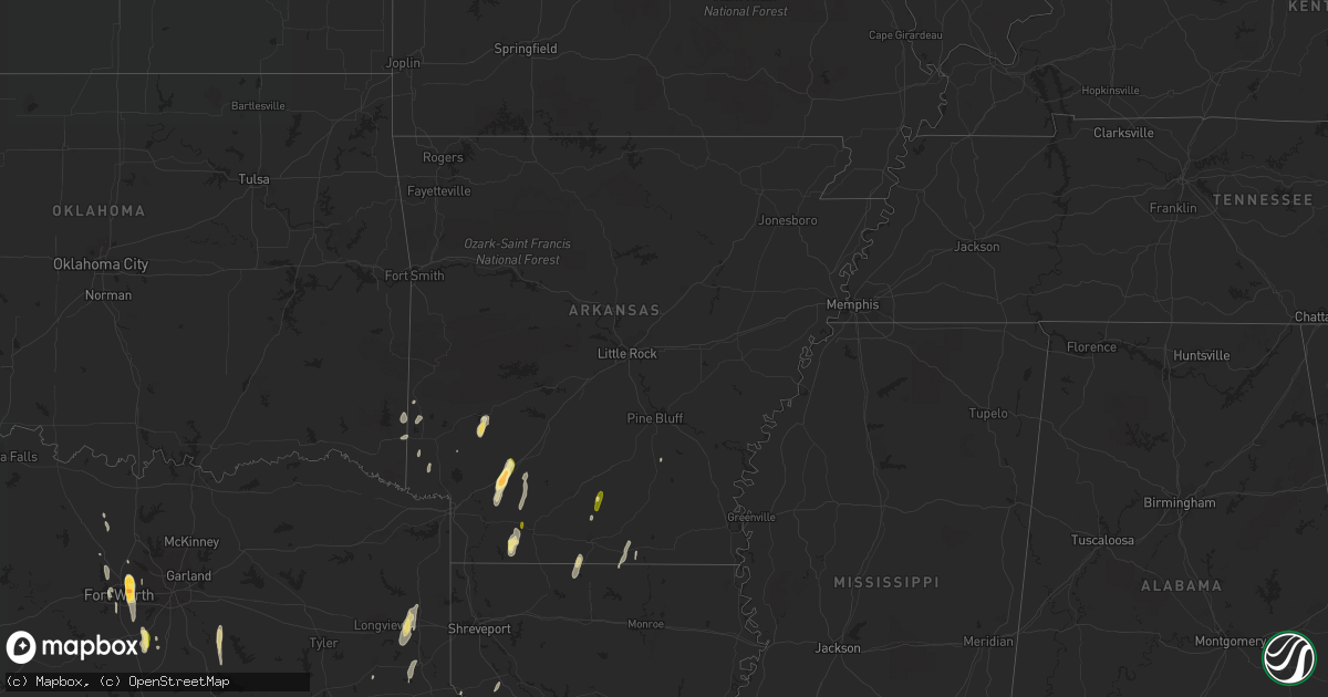
Hail Map in Arkansas on December 27, 2015
Get this storm
December 27 map
$229
one time, instant access
Download today. No call, no setup
Keep the $229
Bought the map and want the full workflow? Apply the entire $229 to a subscription within 7 days. None of it is wasted.
Every map, not just this one
This buys you this map. Subscription and you get every map we run, in the markets you choose from a few cities to whole states to nationwide. Plus real-time alerts the moment a storm fires.
Contact data
Name, contact info, occupancy, even credit band for addresses in the footprint. You go from where it hit to who to call.
Become the source they trust
Unlimited branding weather history reports on demand. You already have the documented answer ready for the property owner, and you are the one who showed up with it.
Property data and RoofTrace estimates
Pull up any address you have got, its value and the exact code rules for that jurisdiction, straight from One Click Code. Then RoofTrace estimates the squares, pitch, and roof value, priced the way you price.
Storm reports in Arkansas
Arkansas
| Date | Description |
|---|---|
| 12/27/20155:10 PM CST | Emergency management reports a house with roof damage in the area. |
| 12/27/20155:10 PM CST | Emergency management reports damage to hermitage school. Several roads in the area closed due to downed trees and power lines. |
| 12/27/20155:06 PM CST | Nws storm survey revealed an ef1 tornado...which stretched from hermitage to sw of warren...or 2 miles ne of farmville. Many pine trees were snapped or uprooted. A shed |
| 12/27/20154:45 PM CST | Damage willisville |
| 12/27/20154:45 PM CST | Hwy 234 |
| 12/27/20154:36 PM CST | An ef-1 tornado snapped and uprooted hundreds of trees...damaged or destroyed several outbuldings...and damaged roofs of several homes along its path. The path length w |
| 12/27/20154:22 PM CST | Trunks of a few pine trees were snapped. Max wind speeds estimated at 80 mph. |
| 12/27/20154:22 PM CST | Tornado on the ground at hwy 41 red river bridge going ne. |
| 12/27/20154:20 PM CST | Nws storm survey team determined that the damage northeast of foreman arkansas was consistent with that of straight line wind damage. Damage consisted of several trees |
| 12/27/20154:10 PM CST | Calhoun sheriffs office reports tornado on ground west of hampton. |
| 12/27/20154:08 PM CST | Golf ball size hail |
| 12/27/20154:05 PM CST | Emergency managers reported structural damage to house around little bay road. |
| 12/27/20154:00 PM CST | Damage willisville |
| 12/27/20153:49 PM CST | Numerous trees and powelines down in the bearden area. Emergency manager reported several homes sustained wind damage and several others had trees fall on them. |
| 12/27/20153:38 PM CST | Straight line winds broke numerous small pine limbs and snapped the trunks of a few large rotted trees. All damage pointed downstream to the northeast. Max wind speeds |
| 12/27/20153:36 PM CST | Tornado partially lifted the roof off of a mobile home along ar355. The tornado continued north and snapped several trees before lifting along hempstead county 9 road. |
| 12/27/20153:36 PM CST | Straight line winds snapped the trunk of a large pine tree. A few other small limbs were also down. All damage pointed downstream to the northeast. Max wind gusts estim |
| 12/27/20154:46 AM CST | Nws storm survey revealed that a tornado caused ef-2 damamge 10 miles sw of mariana. The tornado destroyed mobile homes and caused roof damage to other homes. |
| 12/26/20158:57 PM CST | Tornado snapped and uprooted numerous trees. Several outbuildings were destroyed...and one home had roof damage. |
| 12/26/20158:30 PM CST | Several large and small limbs down |
| 12/26/20156:30 PM CST | Emergency management reports house with roof damage in the area. |
| 12/26/20156:06 PM CST | Nws storm survey revealed an ef-1 tornado...which knocked down several pine trees. Some pine trees were snapped...and a roof was ripped off a home and thrown to the nw |
Cities Impacted by Hail Map on December 27, 2015
- Grandview, TX
- Midlothian, TX
- Venus, TX
- Maypearl, TX
- Chatfield, TX
- Scurry, TX
- Kemp, TX
- Kaufman, TX
- Fort Worth, TX
- Arlington, TX
- Haltom City, TX
- North Richland Hills, TX
- Hurst, TX
- Keller, TX
- Wortham, TX
- Richland, TX
- Hope, AR
- Prescott, AR
- Emmet, AR
- Gustine, TX
- Hamilton, TX
- Pottsville, TX
- Goldthwaite, TX
- Star City, AR
- Napoleonville, LA
- Bernice, LA
- Junction City, AR
- Lillie, LA
- Summerfield, LA
- Mansfield, LA
- Roanoke, TX
- Hallsville, TX
- Marshall, TX
- Tatum, TX
- Rhome, TX
- San Saba, TX
- Murfreesboro, AR
- Coupland, TX
- Logansport, LA
- Crowley, TX
- Stamps, AR
- Taylor, AR
- Bronson, TX
- San Augustine, TX
- Magnolia, AR
- Colmesneil, TX
- Woodville, TX
- Cove, AR
- Wickes, AR
- Lampasas, TX
- Lometa, TX
- Hampton, AR
- Chireno, TX
- Nashville, AR
- Center, TX
- Decatur, TX
- Wells, TX
- Alto, TX
- Thrall, TX
- Taylor, TX
- Huntington, TX
- Kennedale, TX
- Colleyville, TX
- Mansfield, TX
- Bedford, TX
- Alvarado, TX
- Waxahachie, TX
- Naval Air Station Jrb, TX
- Houston, TX
- Broaddus, TX
- Laneville, TX
- Euless, TX
- Kerens, TX
- Rice, TX
- Powell, TX
- Waldo, AR
- Paris, TX
- Grapeland, TX
- Kennard, TX
- Moscow, TX
- Corrigan, TX
- Gillham, AR
- Grannis, AR
- Newark, TX
- Splendora, TX
- Cleveland, TX
- New Caney, TX
- Zavalla, TX
- Chester, TX
- Gary, TX
- Converse, LA
- Wimberley, TX
- Driftwood, TX
- Corsicana, TX
- Mexia, TX
- Marion, LA
- Shelbyville, TX
- Alleene, AR
- Ashdown, AR
- Carthage, TX
- Amity, AR
- Horatio, AR
- Huttig, AR
- Eagletown, OK
- De Queen, AR
- Saltillo, TX
- Livingston, TX
- Watson, OK
- Dike, TX
- Kingwood, TX
- Porter, TX
- Strong, AR
- Nacogdoches, TX
- Louann, AR
- Brenham, TX
- Austin, TX
- Buda, TX
- Rosston, AR
- Willisville, AR
- Crockett, TX


