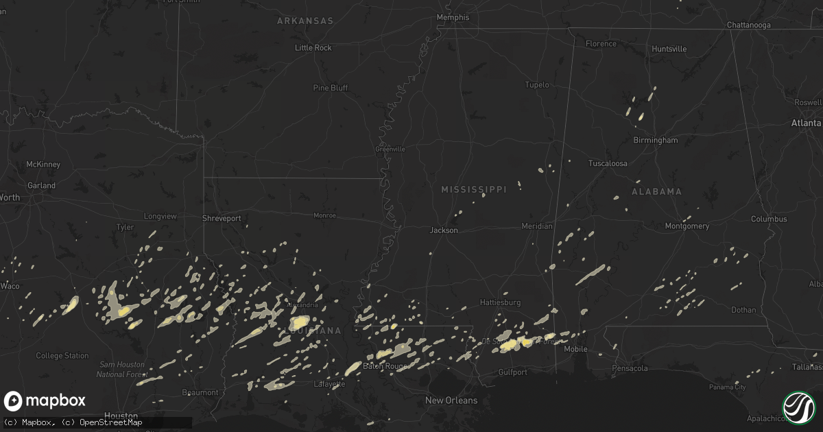
Hail Map in Mississippi on December 25, 2012
Get this storm
December 25 map
$229
one time, instant access
Download today. No call, no setup
Keep the $229
Bought the map and want the full workflow? Apply the entire $229 to a subscription within 7 days. None of it is wasted.
Every map, not just this one
This buys you this map. Subscription and you get every map we run, in the markets you choose from a few cities to whole states to nationwide. Plus real-time alerts the moment a storm fires.
Contact data
Name, contact info, occupancy, even credit band for addresses in the footprint. You go from where it hit to who to call.
Become the source they trust
Unlimited branding weather history reports on demand. You already have the documented answer ready for the property owner, and you are the one who showed up with it.
Property data and RoofTrace estimates
Pull up any address you have got, its value and the exact code rules for that jurisdiction, straight from One Click Code. Then RoofTrace estimates the squares, pitch, and roof value, priced the way you price.
Storm reports in Mississippi
Mississippi
| Date | Description |
|---|---|
| 12/25/20124:50 PM CST | Few trees down around the county. One on kimberly drive rd. |
| 12/25/20124:36 PM CST | A tree was blown down onto a house along wesley chapel road |
| 12/25/20124:35 PM CST | Nws storm survey found an ef0 tornado with maximum winds of 82mph...path length of 2.3 miles and maximum width of 50yds. The tornado touched down on county road 356 pro |
| 12/25/20124:30 PM CST | A few homes reported damaged in mclain. Mclain elementary school experienced minor damage. Time estimated. |
| 12/25/20124:25 PM CST | Reports of tree across the road on south price street in enterprise. |
| 12/25/20124:25 PM CST | Reports of tree across the road on south price street in enterprise. Possible tornado. |
| 12/25/20124:15 PM CST | 4 homes with major structural damage along tornado path. Numerous reports of damage along tornado track across southern perry county. |
| 12/25/20124:07 PM CST | Structural damage along ovett-moselle road. A camper was rolled over. |
| 12/25/20124:07 PM CST | Nws storm survey found an ef1 tornado with maximum winds of 105mph...path length of 1 mile and maximum width of 100yds. Numerous hardwood and softwood trees were uproot |
| 12/25/20124:04 PM CST | *** 4 inj *** major structural damage along j bailey road. 4 injuries at this location |
| 12/25/20124:00 PM CST | Numerous reports of a tornado crossing us highway 49 near ms highway 13. Trees and power lines reported down in the area. |
| 12/25/20124:00 PM CST | One tree down. |
| 12/25/20123:55 PM CST | Tree downed on a power line on county road 747 |
| 12/25/20123:55 PM CST | Stone county emergency management reports mobile homes destroyed and 2 houses with roofs blown off. |
| 12/25/20123:54 PM CST | Structure damage reported by public. |
| 12/25/20123:50 PM CST | *** 4 inj *** nws storm survey teams found an ef2 tornado with maximum winds of 130mph...path length of 7.5 miles and maximum width of 300 yds. Numerous soft and hardwo |
| 12/25/20123:50 PM CST | Couple of trees down in harperville. |
| 12/25/20123:48 PM CST | Reported at 865 magnolia road in texas community. |
| 12/25/20123:47 PM CST | Trees and power lines downed blocking ms highway 395 near the winston county line |
| 12/25/20123:45 PM CST | Trees down on highway 19...one near marty stuart drive...another near the bethsaida community. |
| 12/25/20123:45 PM CST | Reports of a tree down in pinola. |
| 12/25/20123:42 PM CST | *** 2 inj *** lawrence county s.o. Reports tornado moved through the area north of monticello near u.s. 84 and ms highway 27. One mobile home was flipped. Additional st |
| 12/25/20123:38 PM CST | Two mobile homes damaged along highway 184 west of monticello. Possible tornado. |
| 12/25/20123:37 PM CST | Trees downed along james cox rd. Possible tornado. |
| 12/25/20123:36 PM CST | Power lines and trees down along ford colcote road. Insulation and tin in trees. |
| 12/25/20123:35 PM CST | *** 7 inj *** nws storm survey found an ef2 tornado with maximum winds of 120mph...path length of 9.2 miles and maximum width of 0.25 miles. A total of 7 injuries occur |
| 12/25/20123:25 PM CST | Reports of a tree and powerline down in braxton. |
| 12/25/20123:20 PM CST | Reports of trees down on highway 43 near thomastown. |
| 12/25/20123:20 PM CST | Law enforcement reported possible tornado damage on white chapel rd. |
| 12/25/20123:15 PM CST | Reports of tree across highway 51 close to dixon road. |
| 12/25/20122:56 PM CST | Possible tornado damage with trailers damaged and tree on house on fort street. |
| 12/25/20122:42 PM CST | Large tree downed along madison ave near us highway 51. |
| 12/25/20122:40 PM CST | Reports of tree down on barlow road and awning ripped off home on highway 28. |
| 12/25/20122:32 PM CST | Possible tornado downed a medium sized tree on gordon street. |
| 12/25/20122:32 PM CST | *** 1 inj *** county emergency manager reported twelve trailers heavily damaged and one destroyed. Head start building roof heavily damaged. Two houses heavily damaged |
| 12/25/20122:30 PM CST | Few trees down around roxie. |
| 12/25/20122:17 PM CST | *** 2 inj *** reports that a large tree fell and destroyed a house in edwards. 2 injuries occurred but were non life-threatening. |
| 12/25/20122:10 PM CST | Few trees down around the county. |
| 12/25/20122:00 PM CST | Reports of a few trees down on highway 553. |
| 12/25/20121:48 PM CST | Trees down just south of hez airport |
| 12/25/20121:45 PM CST | Two trees down. One on jeff davis rd the other on oak ridge road. |
| 12/25/20121:45 PM CST | Several trees were downed in the area around deerfield road...pipe lake...and delta lake in southeastern adams county. Time estimated based on radar data. |
| 12/25/20121:40 PM CST | Large tree down over road and several limbs down in port gibson. |
| 12/25/20121:25 PM CST | A business and some apartment buildings had siding damage...a fence was downed...a stop sign was bent over and some small trees were snapped. |
| 12/25/20121:22 PM CST | Measured at kjan asos. Fence blown over at nws office. |
| 12/25/20121:22 PM CST | A few signs were bent over...a gate was damaged...and a tree fell on a fence at jackson international airport. |
| 12/24/20127:20 PM CST | Two homes damaged...one with significant roof damage. The other experienced minor damage. Trees also down. |
All States Impacted by Hail Map on December 25, 2012
Cities Impacted by Hail Map on December 25, 2012
- Centreville, AL
- Rutledge, AL
- Brantley, AL
- Tallahassee, FL
- San Augustine, TX
- Grosse Tete, LA
- Lucedale, MS
- Franklinton, LA
- Angie, LA
- Natchitoches, LA
- Wiggins, MS
- Perkinston, MS
- Merryville, LA
- Deridder, LA
- Pitkin, LA
- Leesville, LA
- Clayton, AL
- Noxapater, MS
- Saint Francisville, LA
- Empire, AL
- New Llano, LA
- Hornbeck, LA
- Florien, LA
- Wiergate, TX
- Hemphill, TX
- Many, LA
- Smithdale, MS
- Liberty, MS
- Groveton, TX
- McLain, MS
- Jonesboro, TX
- Provencal, LA
- Canton, MS
- Olla, LA
- Trout, LA
- Magnolia, MS
- Centreville, MS
- Clinton, LA
- Norwood, LA
- Coushatta, LA
- Youngsville, LA
- Joaquin, TX
- Center, TX
- Ellisville, MS
- Petal, MS
- Moselle, MS
- Baton Rouge, LA
- Wilson, LA
- Walker, LA
- Greensburg, LA
- Pride, LA
- Zachary, LA
- Baker, LA
- Holden, LA
- Amite, LA
- Pine Grove, LA
- Greenwell Springs, LA
- Denham Springs, LA
- Slaughter, LA
- Opp, AL
- Elba, AL
- Dozier, AL
- Roseland, LA
- Fluker, LA
- Hull, TX
- Liberty, TX
- Dayton, TX
- Cleveland, TX
- Poplarville, MS
- Reagan, TX
- Anacoco, LA
- Hattiesburg, MS
- Marion, AL
- Franklin, TX
- Walnut Springs, TX
- Glen Rose, TX
- Cushing, TX
- Glenmora, LA
- Forest Hill, LA
- Elmer, LA
- Woodworth, LA
- Lecompte, LA
- Cullman, AL
- Trinity, TX
- Bremond, TX
- Grapeland, TX
- Waco, TX
- Aquilla, TX
- Purvis, MS
- Leakesville, MS
- Vinegar Bend, AL
- McHenry, MS
- Bogalusa, LA
- Georgiana, AL
- Breaux Bridge, LA
- Arnaudville, LA
- Morgan, TX
- Brooklyn, MS
- Morgan City, LA
- Macon, MS
- Toxey, AL
- Butler, AL
- Milam, TX
- Hessmer, LA
- Mansura, LA
- Laneville, TX
- Newton, TX
- Jasper, TX
- Ball, LA
- Pollock, LA
- Pineville, LA
- Alexandria, LA
- Boyce, LA
- Crockett, TX
- Jewett, TX
- Marquez, TX
- McIntosh, AL
- Little River, AL
- Jackson, AL
- Lafayette, LA
- Zavalla, TX
- Broaddus, TX
- Winnfield, LA
- Carthage, MS
- Lake Charles, LA
- Hineston, LA
- Noble, LA
- Thomasville, AL
- Carriere, MS
- Covington, LA
- Abita Springs, LA
- Picayune, MS
- Pearl River, LA
- Bush, LA
- Elizabeth, LA
- Oakdale, LA
- West, TX
- Elkhart, TX
- Bronson, TX
- Pineland, TX
- Dequincy, LA
- Gatesville, TX
- Roxie, MS
- Washington, LA
- Marthaville, LA
- Calvert, TX
- Luverne, AL
- Fisher, LA
- Creola, AL
- Midway, AL
- Summit, MS
- Carrollton, AL
- Andalusia, AL
- Red Level, AL
- Dickinson, AL
- Saint Martinville, LA
- Saucier, MS
- Welsh, LA
- Etoile, TX
- Troup, TX
- Saint Stephens, AL
- Grove Hill, AL
- Sieper, LA
- Otis, LA
- Lena, LA
- Rusk, TX
- Alto, TX
- Apple Springs, TX
- Lovelady, TX
- Kennard, TX
- Pennington, TX
- Gary, TX
- Lufkin, TX
- Nacogdoches, TX
- Patterson, LA
- Franklin, LA
- Crane Hill, AL
- Arley, AL
- Woodville, MS
- Shelbyville, TX
- Temple, TX
- Wetumpka, AL
- Ville Platte, LA
- Bunkie, LA
- Saint Landry, LA
- Lumberton, MS
- Gilbertown, AL
- Kentwood, LA
- Rosebud, TX
- Dodson, LA
- Goldonna, LA
- Banks, AL
- Mamou, LA
- Riesel, TX
- Marlin, TX
- Kountze, TX
- Loranger, LA
- Independence, LA
- Satsuma, AL
- Livingston, AL
- Greenville, AL
- York, AL
- Buffalo, TX
- State Line, MS
- Hosford, FL
- Jachin, AL
- Ward, AL
- China Spring, TX
- Reklaw, TX
- Jacksonville, TX
- Colfax, LA
- Sulphur, LA
- Westlake, LA
- Valley Mills, TX
- Crawford, TX
- Maringouin, LA
- Hanceville, AL
- Monterey, LA
- Huntington, TX
- Corrigan, TX
- Shelbyville, TN
- Osyka, MS
- Panama City, FL
- Lott, TX
- Sweet Water, AL
- Linden, AL
- Broussard, LA
- Deville, LA
- Lower Peach Tree, AL
- Roanoke, LA
- Silsbee, TX
- Woodville, TX
- Warren, TX
- Iota, LA
- Beaumont, TX
- Centerville, TX
- Dry Prong, LA
- Jennings, LA
- Basile, LA
- Eunice, LA
- Elton, LA
- Ethel, LA
- Mittie, LA
- Dry Creek, LA
- Abbott, TX
- Penelope, TX
- Ringgold, LA
- Flatwoods, LA
- Blountstown, FL
- Church Point, LA
- Lottie, LA
- Goshen, AL
- Waynesboro, MS
- Silas, AL
- Jasper, AL
- Duson, LA
- Oberlin, LA
- Fred, TX
- Loxley, AL
- Robertsdale, AL
- Hammond, LA
- Robert, LA
- Effie, LA
- Marksville, LA
- Chireno, TX
- Valdosta, GA
- Quitman, GA
- Troy, AL
- Angola, LA
- Henderson, TX
- Florala, AL
- McKenzie, AL
- Evergreen, AL
- Mandeville, LA
- Branch, LA
- Tylertown, MS
- Molino, FL
- Natchez, MS
- Chunchula, AL
- Wilmer, AL
- Buna, TX
- Ozark, AL
- Skipperville, AL
- Fayetteville, TN
- Bristol, FL
- Port Allen, LA
- Saraland, AL
- Erwinville, LA
- Lakeland, LA
- Prairieville, LA
- Bremen, AL
- Sumiton, AL
- Clarksville, FL
- Eight Mile, AL
- Semmes, AL
- Quinton, AL
- Burkeville, TX
- Lisman, AL
- Cheneyville, LA
- Crosby, MS
- Jackson, LA
- Oakwood, TX
- Converse, LA
- Iowa, LA
- Lake Arthur, LA
- Bell City, LA
- Youngstown, FL
- Rayne, LA
- Gueydan, LA
- Montgomery, AL
- Columbia, MS
- Foxworth, MS
- Jonesville, LA
- Saratoga, TX
- Kilgore, TX
- Overton, TX
- Hubbard, TX
- Port Barre, LA
- Canton, TX
- Reeves, LA
- Kinder, LA
- Hillsboro, TX
- Sunset, LA
- Opelousas, LA
- Diboll, TX
- Millbrook, AL
- Zwolle, LA
- Colmesneil, TX
- Kinston, AL
- Philadelphia, MS
- Wells, TX
- Pollok, TX
- Gloster, MS
- Brewton, AL
- Newville, AL
- Clopton, AL
- Dixie, GA
- Saline, LA
- Crystal Springs, MS
- Jena, LA
- Springfield, LA
- Ponchatoula, LA
- Trinidad, TX
- Purmela, TX
- Robeline, LA
- Albany, LA
- Livingston, LA
- Tickfaw, LA
- Natchez, LA
- Quitman, MS
- Stonewall, MS


