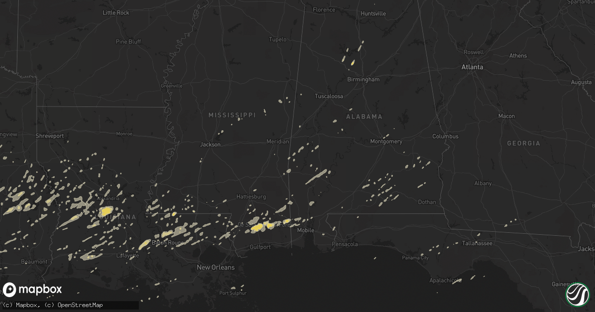
Hail Map on December 25, 2012
Get this storm
December 25 map
$229
one time, instant access
Download today. No call, no setup
Keep the $229
Bought the map and want the full workflow? Apply the entire $229 to a subscription within 7 days. None of it is wasted.
Every map, not just this one
This buys you this map. Subscription and you get every map we run, in the markets you choose from a few cities to whole states to nationwide. Plus real-time alerts the moment a storm fires.
Contact data
Name, contact info, occupancy, even credit band for addresses in the footprint. You go from where it hit to who to call.
Become the source they trust
Unlimited branding weather history reports on demand. You already have the documented answer ready for the property owner, and you are the one who showed up with it.
Property data and RoofTrace estimates
Pull up any address you have got, its value and the exact code rules for that jurisdiction, straight from One Click Code. Then RoofTrace estimates the squares, pitch, and roof value, priced the way you price.
States Impacted by Hail Map on December 25, 2012
Storm reports
Alabama
| Date | Description |
|---|---|
| 12/25/20125:59 PM CST | Tree damage near deer park. |
| 12/25/20125:57 PM CST | Trees down and property damage near gallion. |
| 12/25/20125:57 PM CST | Trees down and property damage near gallion |
| 12/25/20125:54 PM CST | The ef1 tornado had winds up to 100 mph...damaged several homes and mobile homes...snapped and uprooted hundreds of trees. The tornado began 2 sse demopolis and lifted |
| 12/25/20125:52 PM CST | Another tree down on highway 69 n. Dot responded and removed it. |
| 12/25/20125:51 PM CST | Another tree down on highway 69 n. Dot responded and removed it. |
| 12/25/20125:50 PM CST | The ef1 tornado had winds up to 100 mph...damaged several homes and mobile homes...snapped and uprooted hundreds of trees. The tornado began 2 sse demopolis and lifted |
| 12/25/20125:36 PM CST | Multiple trees down on cr 4425. One home damaged on cr 4427. Possible damage to other homes. |
| 12/25/20125:30 PM CST | Multiple trees down on cr 4425. Two homes damaged on cr 4438. Numerous trees snapped off or uprooted along a 3.66 mile path in pike county. The tornado first touched do |
| 12/25/20125:04 PM CST | Several trees were blown down along highway 39 in western greene county near clinton. The trees blocked half the highway. |
| 12/25/20125:00 PM CST | A few trees were blown down and a few light poles were knocked over in and around prattville.a vehicle hit a tree that was down in the road but the occupants were not i |
| 12/25/20125:00 PM CST | A few homes reported shingle damage near west greene. |
| 12/25/20124:59 PM CST | Apparent large tornado seen on local television tower cameras moving into downtown mobile. |
| 12/25/20124:54 PM CST | Choctaw ema relayed tornado sighting in riderwood |
| 12/25/20124:53 PM CST | Choctaw ema relayed report of a tornado by citizen from riderwood. |
| 12/25/20124:40 PM CST | Public reported tornado approaching exit 15 of interstate 10. |
| 12/25/20124:30 PM CST | Ema relayed public reports of tornado north of luverne |
| 12/25/20124:22 PM CST | Reports of homes damaged in luverne area. |
| 12/25/20123:55 PM CST | Trees were blown down along marengo road 8 between sweetwater and dixons mill. |
| 12/25/20123:54 PM CST | Structure damage reported by public. |
| 12/25/20123:48 PM CST | Reported at 865 magnolia road in texas community. |
| 12/25/20123:31 PM CST | Possible tornado reported to county emergency management. Brief touchdown no reports of damage at this time. |
| 12/25/20123:20 PM CST | Trees were blown down along marengo road 8 between sweetwater and dixons mill. Several additional trees were blown down in vangale community. |
| 12/25/20123:15 PM CST | An ef1 tornado snapped or uprooted numerous trees from hoboken road to southern pines drive...west of dixons mill. |
| 12/25/20121:49 PM CST | Several trees were blown down in a small area along highway 69 south of moundville. Winds were estimated 50 to 55 mph. |
| 12/25/20121:26 PM CST | A few trees and power lines were blown down in geiger along highway 17. A few mobile homes had their underpinned removed. Winds were estimated at 40 to 50 mph. |
| 12/25/201212:40 AM CST | 2 trees and a powerline knocked down. |
| 12/24/201211:06 PM CST | A few trees were blown down near the intersection of county road 54 and county road 37. |
| 12/24/201210:38 PM CST | A few large trees were blown down and blocked the roadway near the fitzpatrick community. This occurred near highway 110 and county road 7. |
| 12/24/201210:28 PM CST | Multiple mobile homes turned over. Possible tornado. |
| 12/24/201210:20 PM CST | Power lines down near intersection of long rd and mt. Lebanon rd |
| 12/24/20129:40 PM CST | Modular home porch blown off and roof peeled off. Trees and power lines down. |
| 12/24/20129:38 PM CST | Modular home porch blown off and roof peeled off. Several trees and power lines down in the area. |
| 12/24/20129:38 PM CST | Barn destroyed. |
| 12/24/20129:30 PM CST | Several trees and power lines blown down along county road 24 and county road 45. |
| 12/24/20129:10 PM CST | *** 1 fatal *** 1 person seriously injured when a tree fell on a house...later died at the hospital. |
| 12/24/20129:08 PM CST | *** 1 fatal *** 1 man seriously injured at 16 county lane when a large pine tree was blown over into a house. The man later died at the hospital the next day. |
| 12/24/20129:05 PM CST | One metal barn was destroyed and one barn had the metal roof removed. |
| 12/24/20128:46 PM CST | Trees and powerlines blown down on highway 80 west of dannelly field. Highway blocked. |
| 12/24/20128:46 PM CST | A few trees were blown down in and around prattville. A vehicle ran into a downed tree on highway 31. |
| 12/24/20128:45 PM CST | Trees down along lake berry road. Road impassable. Possible tornado. |
| 12/24/20128:42 PM CST | Farm damaged along frederick douglas rd near highway 80. Possible tornado. |
| 12/24/20128:37 PM CST | Multiple trees down on highway 97 between lowndesboro and hayneville. Possible tornado. |
| 12/24/20128:35 PM CST | 18 wheeler overturned near atmore |
| 12/24/20128:35 PM CST | Damage near fast lane gas station on jack springs road 1/2 mile south of exit 54 and i-65. 18 wheelers overturned. House behind gas station on fire. |
| 12/24/20128:09 PM CST | A few trees were blown down in northern coosa county around weogufka. |
| 12/24/20127:58 PM CST | Power lines were blown down in the alpine community. |
| 12/24/20127:58 PM CST | Power lines were blown down in the alpine community. |
| 12/24/20127:40 PM CST | Trees down |
| 12/24/20127:25 PM CST | Large trees blocking road. |
| 12/24/20127:24 PM CST | A few homes and trailers are damaged in the nachez hwy area of wilmer. |
| 12/24/20127:23 PM CST | A few trees were blown down in and around pinson. Winds were estimated at 40 to 50 mph. |
| 12/24/20127:15 PM CST | Quarter size hail reported. Winds estimated at 60-70 mph. |
| 12/24/20126:59 PM CST | Tree and some structural damage reported near deer park. |
| 12/24/20126:37 PM CST | Several trees were blown down along county road 48. |
| 12/24/20126:36 PM CST | Fire chief reports several trees down on county rd 12. |
| 12/24/20126:15 PM CST | Report of trees down around county rd 514 nw of new brockton |
| 12/24/20126:12 PM CST | Debris from a destroyed barn and trees blocking us hwy 43 south of grove hill. |
| 12/24/20126:00 PM CST | Extensive damage to two mobile homes off highway 80 between demopolis and highway 69 cross over. Roof blown off one mobile home. |
Texas
| Date | Description |
|---|---|
| 12/25/201212:28 PM CST | Vidor police report an apartment complex at 475 s denver had its roof blown off and debris scattered on the roadway. Photos posted to kbmts facebook indicate damage to |
| 12/25/201212:16 PM CST | This report was determined to be false. |
| 12/25/201211:43 AM CST | Trees downed on powerlines near six mile |
| 12/25/201211:27 AM CST | Tree down across fm 2343 near yellowpine |
| 12/25/201210:48 AM CST | Trees and powerlines down on bland lake rd |
| 12/25/201210:47 AM CST | Large pine tree down 8 mi se of cleveland |
| 12/25/201210:36 AM CST | Trees down on hwy 7 and hwy 96 |
| 12/25/201210:35 AM CST | Abc 13 video report of tree down on house damaging roof and window. |
| 12/25/201210:30 AM CST | Tree down on fm 95 |
| 12/25/201210:20 AM CST | Tree limbs and powerlines down in kings mill subdivision |
| 12/25/201210:12 AM CST | Trees down on oakwood road in lufkin |
| 12/25/201210:09 AM CST | Nickel to quarter size hail at observer residence |
| 12/25/201210:00 AM CST | Roof blown off of a mobile home on highway 103 east in lufkin. Large limbs downed as well. |
| 12/25/20129:40 AM CST | Brief touchdown of an ef-0 tornado was observed by law enforcement near the scene of the earlier ef-3 tornado along highway 287. Some debris was lofted but little to no |
| 12/25/20129:30 AM CST | Lovelady firechief report wind gust of 80 mph |
| 12/25/20129:25 AM CST | Worst of the damage was along highway 287 one mile north of pennington. A feed store and restaurant were completely destroyed by an ef-3 tornado with debris scattered i |
| 12/25/20129:22 AM CST | Trained spotter reported tornado passed through pasture behind home. |
| 12/25/20129:22 AM CST | Public report of tornado damage on 287 with a destroyed building. Lost section of roof on bank. |
| 12/25/20129:10 AM CST | Possible tornado reported near houston county lake |
| 12/25/20129:00 AM CST | Multiple reports of trees down. Roofs lost on metal and wood buildings at hwy 21. |
| 12/25/20128:25 AM CST | Quarter sized hail near mound city |
Louisiana
| Date | Description |
|---|---|
| 12/25/20124:25 PM CST | Trees down on highway 35. |
| 12/25/20124:25 PM CST | Tree down on highway 25 north of clifton. |
| 12/25/20123:30 PM CST | Possible tornado damage...several trees down near hwy 421 in the area of austin rd and at whitestown rd at delee road. Crews are working on whitesdown rd. Trees down on |
| 12/25/20123:23 PM CST | Thunderstorm wind damage...blew down trees...possible tornado. On sidney road. |
| 12/25/20123:05 PM CST | Trees reported down along highway 64 in zachary. Nws storm survey reported wind damage was due to straight line winds. |
| 12/25/20123:05 PM CST | Tornado reported by law enforcement in zachary area. |
| 12/25/20123:00 PM CST | Lafayette sheriff reports partial roof torn off of a porch near north of i-10 off of hwy 93. |
| 12/25/20122:43 PM CST | Tree branches and power lines down in luling. Time estimated by radar. |
| 12/25/20122:41 PM CST | Lafayette skywarn spotter reports a wind gust of 58 mph near opelousas. |
| 12/25/20122:40 PM CST | Large portion of fence blown down behind walmart and damage to the roof of a car wash on highway 90. Time estimated by radar. |
| 12/25/20122:15 PM CST | Storm chaser reports a brief tornado touchdown near ledoux. |
| 12/25/20122:00 PM CST | *** 1 fatal *** one man died when a tree fell on a mobile home along la highway 134 west of epps. Others were able to escape without injury. Additional trees were repor |
| 12/25/20121:30 PM CST | Rapides parish sheriff reports 25-30 homes damaged with numerous injuries. Emergency personnel are having difficulty reaching victims due to the damage. |
| 12/25/20121:30 PM CST | Louisiana gohsep reports of one or two possible tornado touchdowns in the rigolette area. Damage is still being assessed but at this time approximately 43 structures re |
| 12/25/20121:30 PM CST | Off of delta gin rd. One mobile home destroyed with several roofs ripped off of buildings. Storage sheds blown away and damage to doors of a warehouse. Trees and power |
| 12/25/20121:30 PM CST | Trees and powerlines down |
| 12/25/20121:30 PM CST | One mobile home destroyed with damage to other mobile homes and sheds. Two doors were blown off a warehouse and a porch was blown over a mobile home. Trees and large li |
| 12/25/20121:20 PM CST | Reports of damage to a business and significant damage to trailers around glade road and highway 124. Possible tornado. |
| 12/25/20121:19 PM CST | One mobile home destroyed with damage to other mobile homes and sheds. Two doors were blown off a warehouse and a porch was blown over a mobile home. Trees and large li |
| 12/25/20121:19 PM CST | One mobile home destroyed with damage to other mobile homes and sheds. Two doors were blown off a warehouse and a porch was blown over a mobile home. Trees and large li |
| 12/25/20121:14 PM CST | Nws employee estimates wind gust of 60 mph. |
| 12/25/201212:53 PM CST | Alexandria asos reported a 61 mph wind gust. |
| 12/25/201212:51 PM CST | Tree down across hwy 165 |
| 12/25/201212:50 PM CST | Nws storm survey confirms an ef 2 tornado touchdown in the city of alexandria. The tornado produced a damage path 2 miles long and 200 yards wide. Large pieces of roof |
| 12/25/201212:50 PM CST | Nws employee reports a 5th wheel flipped over at 118 woodcreek loop. Numerous pine trees and powerlines are also reported to be down. |
| 12/25/201212:45 PM CST | Tree down on evergreen street |
| 12/25/201212:45 PM CST | *** 1 inj *** nws storm survey confirmed an ef 2 tornado touchdown in the town of tioga. The tornado produced a damage path four miles long and 1/2 mile wide. The torna |
| 12/25/201212:43 PM CST | Nws storm survey team confirms an ef 0 tornado touchdown three miles east of the town of pitkin. The tornado produced a damage path two miles long and 200 yards wide. T |
| 12/25/201212:34 PM CST | State police report damage to a barn and trees down near pitkin as the result of a possible tornado. Time estimated by radar. |
| 12/25/201212:16 PM CST | Beauregard parish emergency manager reports trees and powerlines down in merryville. Time estimated by radar. |
| 12/25/201212:15 PM CST | Trees and powerlines down along hwy 126 |
| 12/25/201212:12 PM CST | Tree down on hwy 501 near mill community |
| 12/25/201211:56 AM CST | Dequincy police report a tree blown over onto powerlines along hwy 389 and 204 resulting in power outages across the dequincy area. |
| 12/25/201211:35 AM CST | Tree down on hwy 71 just south of crossroads |
| 12/24/20126:20 PM CST | Gas station sign blown over and minor damage to a wendys drive through awning near barataria and lapalco in marrero. Storm survey confirmed ef0 tornado. |
| 12/24/20126:15 PM CST | Gas station sign blown over and minor damage to a wendys drive through awning near barataria and lapalco in marrero. |
Mississippi
| Date | Description |
|---|---|
| 12/25/20124:50 PM CST | Few trees down around the county. One on kimberly drive rd. |
| 12/25/20124:36 PM CST | A tree was blown down onto a house along wesley chapel road |
| 12/25/20124:35 PM CST | Nws storm survey found an ef0 tornado with maximum winds of 82mph...path length of 2.3 miles and maximum width of 50yds. The tornado touched down on county road 356 pro |
| 12/25/20124:30 PM CST | A few homes reported damaged in mclain. Mclain elementary school experienced minor damage. Time estimated. |
| 12/25/20124:25 PM CST | Reports of tree across the road on south price street in enterprise. |
| 12/25/20124:25 PM CST | Reports of tree across the road on south price street in enterprise. Possible tornado. |
| 12/25/20124:15 PM CST | 4 homes with major structural damage along tornado path. Numerous reports of damage along tornado track across southern perry county. |
| 12/25/20124:07 PM CST | Nws storm survey found an ef1 tornado with maximum winds of 105mph...path length of 1 mile and maximum width of 100yds. Numerous hardwood and softwood trees were uproot |
| 12/25/20124:07 PM CST | Structural damage along ovett-moselle road. A camper was rolled over. |
| 12/25/20124:04 PM CST | *** 4 inj *** major structural damage along j bailey road. 4 injuries at this location |
| 12/25/20124:00 PM CST | Numerous reports of a tornado crossing us highway 49 near ms highway 13. Trees and power lines reported down in the area. |
| 12/25/20124:00 PM CST | One tree down. |
| 12/25/20123:55 PM CST | Stone county emergency management reports mobile homes destroyed and 2 houses with roofs blown off. |
| 12/25/20123:55 PM CST | Tree downed on a power line on county road 747 |
| 12/25/20123:54 PM CST | Structure damage reported by public. |
| 12/25/20123:50 PM CST | *** 4 inj *** nws storm survey teams found an ef2 tornado with maximum winds of 130mph...path length of 7.5 miles and maximum width of 300 yds. Numerous soft and hardwo |
| 12/25/20123:50 PM CST | Couple of trees down in harperville. |
| 12/25/20123:48 PM CST | Reported at 865 magnolia road in texas community. |
| 12/25/20123:47 PM CST | Trees and power lines downed blocking ms highway 395 near the winston county line |
| 12/25/20123:45 PM CST | Trees down on highway 19...one near marty stuart drive...another near the bethsaida community. |
| 12/25/20123:45 PM CST | Reports of a tree down in pinola. |
| 12/25/20123:42 PM CST | *** 2 inj *** lawrence county s.o. Reports tornado moved through the area north of monticello near u.s. 84 and ms highway 27. One mobile home was flipped. Additional st |
| 12/25/20123:38 PM CST | Two mobile homes damaged along highway 184 west of monticello. Possible tornado. |
| 12/25/20123:37 PM CST | Trees downed along james cox rd. Possible tornado. |
| 12/25/20123:36 PM CST | Power lines and trees down along ford colcote road. Insulation and tin in trees. |
| 12/25/20123:35 PM CST | *** 7 inj *** nws storm survey found an ef2 tornado with maximum winds of 120mph...path length of 9.2 miles and maximum width of 0.25 miles. A total of 7 injuries occur |
| 12/25/20123:25 PM CST | Reports of a tree and powerline down in braxton. |
| 12/25/20123:20 PM CST | Law enforcement reported possible tornado damage on white chapel rd. |
| 12/25/20123:20 PM CST | Reports of trees down on highway 43 near thomastown. |
| 12/25/20123:15 PM CST | Reports of tree across highway 51 close to dixon road. |
| 12/25/20122:56 PM CST | Possible tornado damage with trailers damaged and tree on house on fort street. |
| 12/25/20122:42 PM CST | Large tree downed along madison ave near us highway 51. |
| 12/25/20122:40 PM CST | Reports of tree down on barlow road and awning ripped off home on highway 28. |
| 12/25/20122:32 PM CST | *** 1 inj *** county emergency manager reported twelve trailers heavily damaged and one destroyed. Head start building roof heavily damaged. Two houses heavily damaged |
| 12/25/20122:32 PM CST | Possible tornado downed a medium sized tree on gordon street. |
| 12/25/20122:30 PM CST | Few trees down around roxie. |
| 12/25/20122:17 PM CST | *** 2 inj *** reports that a large tree fell and destroyed a house in edwards. 2 injuries occurred but were non life-threatening. |
| 12/25/20122:10 PM CST | Few trees down around the county. |
| 12/25/20122:00 PM CST | Reports of a few trees down on highway 553. |
| 12/25/20121:48 PM CST | Trees down just south of hez airport |
| 12/25/20121:45 PM CST | Several trees were downed in the area around deerfield road...pipe lake...and delta lake in southeastern adams county. Time estimated based on radar data. |
| 12/25/20121:45 PM CST | Two trees down. One on jeff davis rd the other on oak ridge road. |
| 12/25/20121:40 PM CST | Large tree down over road and several limbs down in port gibson. |
| 12/25/20121:25 PM CST | A business and some apartment buildings had siding damage...a fence was downed...a stop sign was bent over and some small trees were snapped. |
| 12/25/20121:22 PM CST | A few signs were bent over...a gate was damaged...and a tree fell on a fence at jackson international airport. |
| 12/25/20121:22 PM CST | Measured at kjan asos. Fence blown over at nws office. |
| 12/24/20127:20 PM CST | Two homes damaged...one with significant roof damage. The other experienced minor damage. Trees also down. |
Florida
| Date | Description |
|---|---|
| 12/24/201211:35 PM CST | Tree down at the intersection of kings lake rd and highway 90. |
Cities Impacted by Hail Map on December 25, 2012
- Centreville, AL
- Rutledge, AL
- Brantley, AL
- Tallahassee, FL
- San Augustine, TX
- Grosse Tete, LA
- Lucedale, MS
- Franklinton, LA
- Angie, LA
- Natchitoches, LA
- Wiggins, MS
- Perkinston, MS
- Merryville, LA
- Deridder, LA
- Pitkin, LA
- Leesville, LA
- Clayton, AL
- Noxapater, MS
- Saint Francisville, LA
- Empire, AL
- New Llano, LA
- Hornbeck, LA
- Florien, LA
- Wiergate, TX
- Hemphill, TX
- Many, LA
- Smithdale, MS
- Liberty, MS
- Groveton, TX
- McLain, MS
- Jonesboro, TX
- Provencal, LA
- Canton, MS
- Olla, LA
- Trout, LA
- Magnolia, MS
- Centreville, MS
- Clinton, LA
- Norwood, LA
- Coushatta, LA
- Youngsville, LA
- Joaquin, TX
- Center, TX
- Ellisville, MS
- Petal, MS
- Moselle, MS
- Baton Rouge, LA
- Wilson, LA
- Walker, LA
- Greensburg, LA
- Pride, LA
- Zachary, LA
- Baker, LA
- Holden, LA
- Amite, LA
- Pine Grove, LA
- Greenwell Springs, LA
- Denham Springs, LA
- Slaughter, LA
- Opp, AL
- Elba, AL
- Dozier, AL
- Roseland, LA
- Fluker, LA
- Hull, TX
- Liberty, TX
- Dayton, TX
- Cleveland, TX
- Poplarville, MS
- Reagan, TX
- Anacoco, LA
- Hattiesburg, MS
- Marion, AL
- Franklin, TX
- Walnut Springs, TX
- Glen Rose, TX
- Cushing, TX
- Glenmora, LA
- Forest Hill, LA
- Elmer, LA
- Woodworth, LA
- Lecompte, LA
- Cullman, AL
- Trinity, TX
- Bremond, TX
- Grapeland, TX
- Waco, TX
- Aquilla, TX
- Purvis, MS
- Leakesville, MS
- Vinegar Bend, AL
- McHenry, MS
- Bogalusa, LA
- Georgiana, AL
- Breaux Bridge, LA
- Arnaudville, LA
- Morgan, TX
- Brooklyn, MS
- Morgan City, LA
- Macon, MS
- Toxey, AL
- Butler, AL
- Milam, TX
- Hessmer, LA
- Mansura, LA
- Laneville, TX
- Newton, TX
- Jasper, TX
- Ball, LA
- Pollock, LA
- Pineville, LA
- Alexandria, LA
- Boyce, LA
- Crockett, TX
- Jewett, TX
- Marquez, TX
- McIntosh, AL
- Little River, AL
- Jackson, AL
- Lafayette, LA
- Zavalla, TX
- Broaddus, TX
- Winnfield, LA
- Carthage, MS
- Lake Charles, LA
- Hineston, LA
- Noble, LA
- Thomasville, AL
- Carriere, MS
- Covington, LA
- Abita Springs, LA
- Picayune, MS
- Pearl River, LA
- Bush, LA
- Elizabeth, LA
- Oakdale, LA
- West, TX
- Elkhart, TX
- Bronson, TX
- Pineland, TX
- Dequincy, LA
- Gatesville, TX
- Roxie, MS
- Washington, LA
- Marthaville, LA
- Calvert, TX
- Luverne, AL
- Fisher, LA
- Creola, AL
- Midway, AL
- Summit, MS
- Carrollton, AL
- Andalusia, AL
- Red Level, AL
- Dickinson, AL
- Saint Martinville, LA
- Saucier, MS
- Welsh, LA
- Etoile, TX
- Troup, TX
- Saint Stephens, AL
- Grove Hill, AL
- Sieper, LA
- Otis, LA
- Lena, LA
- Rusk, TX
- Alto, TX
- Apple Springs, TX
- Lovelady, TX
- Kennard, TX
- Pennington, TX
- Gary, TX
- Lufkin, TX
- Nacogdoches, TX
- Patterson, LA
- Franklin, LA
- Crane Hill, AL
- Arley, AL
- Woodville, MS
- Shelbyville, TX
- Temple, TX
- Wetumpka, AL
- Ville Platte, LA
- Bunkie, LA
- Saint Landry, LA
- Lumberton, MS
- Gilbertown, AL
- Kentwood, LA
- Rosebud, TX
- Dodson, LA
- Goldonna, LA
- Banks, AL
- Mamou, LA
- Riesel, TX
- Marlin, TX
- Kountze, TX
- Loranger, LA
- Independence, LA
- Satsuma, AL
- Livingston, AL
- Greenville, AL
- York, AL
- Buffalo, TX
- State Line, MS
- Hosford, FL
- Jachin, AL
- Ward, AL
- China Spring, TX
- Reklaw, TX
- Jacksonville, TX
- Colfax, LA
- Sulphur, LA
- Westlake, LA
- Valley Mills, TX
- Crawford, TX
- Maringouin, LA
- Hanceville, AL
- Monterey, LA
- Huntington, TX
- Corrigan, TX
- Shelbyville, TN
- Osyka, MS
- Panama City, FL
- Lott, TX
- Sweet Water, AL
- Linden, AL
- Broussard, LA
- Deville, LA
- Lower Peach Tree, AL
- Roanoke, LA
- Silsbee, TX
- Woodville, TX
- Warren, TX
- Iota, LA
- Beaumont, TX
- Centerville, TX
- Dry Prong, LA
- Jennings, LA
- Basile, LA
- Eunice, LA
- Elton, LA
- Ethel, LA
- Mittie, LA
- Dry Creek, LA
- Abbott, TX
- Penelope, TX
- Ringgold, LA
- Flatwoods, LA
- Blountstown, FL
- Church Point, LA
- Lottie, LA
- Goshen, AL
- Waynesboro, MS
- Silas, AL
- Jasper, AL
- Duson, LA
- Oberlin, LA
- Fred, TX
- Loxley, AL
- Robertsdale, AL
- Hammond, LA
- Robert, LA
- Effie, LA
- Marksville, LA
- Chireno, TX
- Valdosta, GA
- Quitman, GA
- Troy, AL
- Angola, LA
- Henderson, TX
- Florala, AL
- McKenzie, AL
- Evergreen, AL
- Mandeville, LA
- Branch, LA
- Tylertown, MS
- Molino, FL
- Natchez, MS
- Chunchula, AL
- Wilmer, AL
- Buna, TX
- Ozark, AL
- Skipperville, AL
- Fayetteville, TN
- Bristol, FL
- Port Allen, LA
- Saraland, AL
- Erwinville, LA
- Lakeland, LA
- Prairieville, LA
- Bremen, AL
- Sumiton, AL
- Clarksville, FL
- Eight Mile, AL
- Semmes, AL
- Quinton, AL
- Burkeville, TX
- Lisman, AL
- Cheneyville, LA
- Crosby, MS
- Jackson, LA
- Oakwood, TX
- Converse, LA
- Iowa, LA
- Lake Arthur, LA
- Bell City, LA
- Youngstown, FL
- Rayne, LA
- Gueydan, LA
- Montgomery, AL
- Columbia, MS
- Foxworth, MS
- Jonesville, LA
- Saratoga, TX
- Kilgore, TX
- Overton, TX
- Hubbard, TX
- Port Barre, LA
- Canton, TX
- Reeves, LA
- Kinder, LA
- Hillsboro, TX
- Sunset, LA
- Opelousas, LA
- Diboll, TX
- Millbrook, AL
- Zwolle, LA
- Colmesneil, TX
- Kinston, AL
- Philadelphia, MS
- Wells, TX
- Pollok, TX
- Gloster, MS
- Brewton, AL
- Newville, AL
- Clopton, AL
- Dixie, GA
- Saline, LA
- Crystal Springs, MS
- Jena, LA
- Springfield, LA
- Ponchatoula, LA
- Trinidad, TX
- Purmela, TX
- Robeline, LA
- Albany, LA
- Livingston, LA
- Tickfaw, LA
- Natchez, LA
- Quitman, MS
- Stonewall, MS