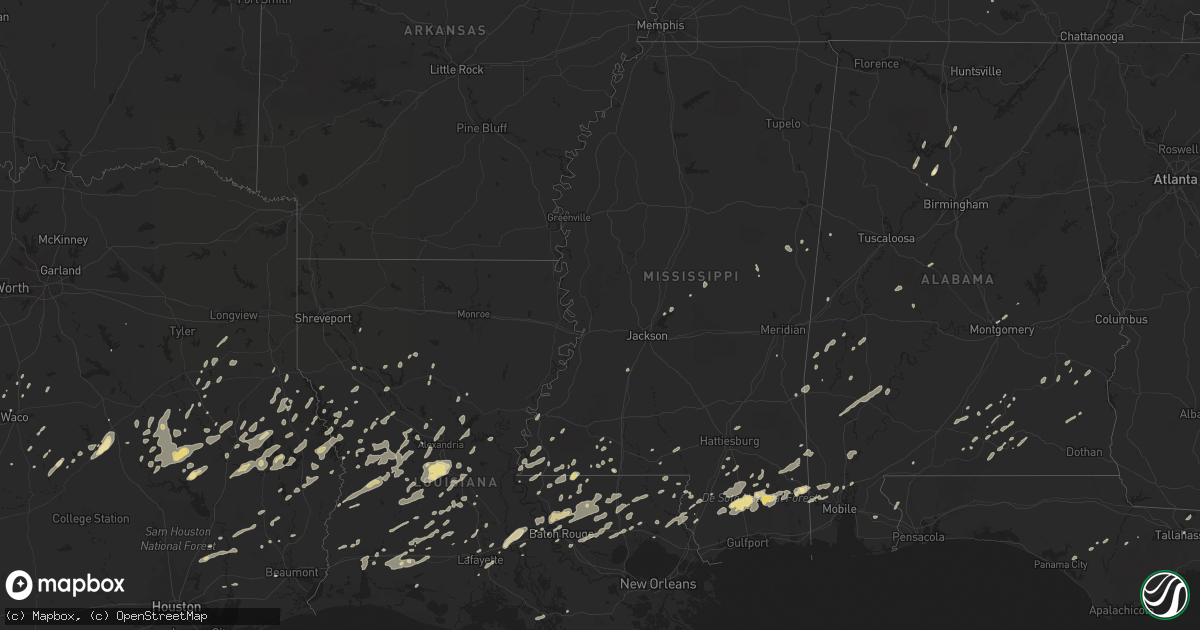
Hail Map in Alabama on December 25, 2012
Get this storm
December 25 map
$229
one time, instant access
Download today. No call, no setup
Keep the $229
Bought the map and want the full workflow? Apply the entire $229 to a subscription within 7 days. None of it is wasted.
Every map, not just this one
This buys you this map. Subscription and you get every map we run, in the markets you choose from a few cities to whole states to nationwide. Plus real-time alerts the moment a storm fires.
Contact data
Name, contact info, occupancy, even credit band for addresses in the footprint. You go from where it hit to who to call.
Become the source they trust
Unlimited branding weather history reports on demand. You already have the documented answer ready for the property owner, and you are the one who showed up with it.
Property data and RoofTrace estimates
Pull up any address you have got, its value and the exact code rules for that jurisdiction, straight from One Click Code. Then RoofTrace estimates the squares, pitch, and roof value, priced the way you price.
Storm reports in Alabama
Alabama
| Date | Description |
|---|---|
| 12/25/20125:59 PM CST | Tree damage near deer park. |
| 12/25/20125:57 PM CST | Trees down and property damage near gallion |
| 12/25/20125:57 PM CST | Trees down and property damage near gallion. |
| 12/25/20125:54 PM CST | The ef1 tornado had winds up to 100 mph...damaged several homes and mobile homes...snapped and uprooted hundreds of trees. The tornado began 2 sse demopolis and lifted |
| 12/25/20125:52 PM CST | Another tree down on highway 69 n. Dot responded and removed it. |
| 12/25/20125:51 PM CST | Another tree down on highway 69 n. Dot responded and removed it. |
| 12/25/20125:50 PM CST | The ef1 tornado had winds up to 100 mph...damaged several homes and mobile homes...snapped and uprooted hundreds of trees. The tornado began 2 sse demopolis and lifted |
| 12/25/20125:36 PM CST | Multiple trees down on cr 4425. One home damaged on cr 4427. Possible damage to other homes. |
| 12/25/20125:30 PM CST | Multiple trees down on cr 4425. Two homes damaged on cr 4438. Numerous trees snapped off or uprooted along a 3.66 mile path in pike county. The tornado first touched do |
| 12/25/20125:04 PM CST | Several trees were blown down along highway 39 in western greene county near clinton. The trees blocked half the highway. |
| 12/25/20125:00 PM CST | A few homes reported shingle damage near west greene. |
| 12/25/20125:00 PM CST | A few trees were blown down and a few light poles were knocked over in and around prattville.a vehicle hit a tree that was down in the road but the occupants were not i |
| 12/25/20124:59 PM CST | Apparent large tornado seen on local television tower cameras moving into downtown mobile. |
| 12/25/20124:54 PM CST | Choctaw ema relayed tornado sighting in riderwood |
| 12/25/20124:53 PM CST | Choctaw ema relayed report of a tornado by citizen from riderwood. |
| 12/25/20124:40 PM CST | Public reported tornado approaching exit 15 of interstate 10. |
| 12/25/20124:30 PM CST | Ema relayed public reports of tornado north of luverne |
| 12/25/20124:22 PM CST | Reports of homes damaged in luverne area. |
| 12/25/20123:55 PM CST | Trees were blown down along marengo road 8 between sweetwater and dixons mill. |
| 12/25/20123:54 PM CST | Structure damage reported by public. |
| 12/25/20123:48 PM CST | Reported at 865 magnolia road in texas community. |
| 12/25/20123:31 PM CST | Possible tornado reported to county emergency management. Brief touchdown no reports of damage at this time. |
| 12/25/20123:20 PM CST | Trees were blown down along marengo road 8 between sweetwater and dixons mill. Several additional trees were blown down in vangale community. |
| 12/25/20123:15 PM CST | An ef1 tornado snapped or uprooted numerous trees from hoboken road to southern pines drive...west of dixons mill. |
| 12/25/20121:49 PM CST | Several trees were blown down in a small area along highway 69 south of moundville. Winds were estimated 50 to 55 mph. |
| 12/25/20121:26 PM CST | A few trees and power lines were blown down in geiger along highway 17. A few mobile homes had their underpinned removed. Winds were estimated at 40 to 50 mph. |
| 12/25/201212:40 AM CST | 2 trees and a powerline knocked down. |
| 12/24/201211:06 PM CST | A few trees were blown down near the intersection of county road 54 and county road 37. |
| 12/24/201210:38 PM CST | A few large trees were blown down and blocked the roadway near the fitzpatrick community. This occurred near highway 110 and county road 7. |
| 12/24/201210:28 PM CST | Multiple mobile homes turned over. Possible tornado. |
| 12/24/201210:20 PM CST | Power lines down near intersection of long rd and mt. Lebanon rd |
| 12/24/20129:40 PM CST | Modular home porch blown off and roof peeled off. Trees and power lines down. |
| 12/24/20129:38 PM CST | Barn destroyed. |
| 12/24/20129:38 PM CST | Modular home porch blown off and roof peeled off. Several trees and power lines down in the area. |
| 12/24/20129:30 PM CST | Several trees and power lines blown down along county road 24 and county road 45. |
| 12/24/20129:10 PM CST | *** 1 fatal *** 1 person seriously injured when a tree fell on a house...later died at the hospital. |
| 12/24/20129:08 PM CST | *** 1 fatal *** 1 man seriously injured at 16 county lane when a large pine tree was blown over into a house. The man later died at the hospital the next day. |
| 12/24/20129:05 PM CST | One metal barn was destroyed and one barn had the metal roof removed. |
| 12/24/20128:46 PM CST | Trees and powerlines blown down on highway 80 west of dannelly field. Highway blocked. |
| 12/24/20128:46 PM CST | A few trees were blown down in and around prattville. A vehicle ran into a downed tree on highway 31. |
| 12/24/20128:45 PM CST | Trees down along lake berry road. Road impassable. Possible tornado. |
| 12/24/20128:42 PM CST | Farm damaged along frederick douglas rd near highway 80. Possible tornado. |
| 12/24/20128:37 PM CST | Multiple trees down on highway 97 between lowndesboro and hayneville. Possible tornado. |
| 12/24/20128:35 PM CST | Damage near fast lane gas station on jack springs road 1/2 mile south of exit 54 and i-65. 18 wheelers overturned. House behind gas station on fire. |
| 12/24/20128:35 PM CST | 18 wheeler overturned near atmore |
| 12/24/20128:09 PM CST | A few trees were blown down in northern coosa county around weogufka. |
| 12/24/20127:58 PM CST | Power lines were blown down in the alpine community. |
| 12/24/20127:58 PM CST | Power lines were blown down in the alpine community. |
| 12/24/20127:40 PM CST | Trees down |
| 12/24/20127:25 PM CST | Large trees blocking road. |
| 12/24/20127:24 PM CST | A few homes and trailers are damaged in the nachez hwy area of wilmer. |
| 12/24/20127:23 PM CST | A few trees were blown down in and around pinson. Winds were estimated at 40 to 50 mph. |
| 12/24/20127:15 PM CST | Quarter size hail reported. Winds estimated at 60-70 mph. |
| 12/24/20126:59 PM CST | Tree and some structural damage reported near deer park. |
| 12/24/20126:37 PM CST | Several trees were blown down along county road 48. |
| 12/24/20126:36 PM CST | Fire chief reports several trees down on county rd 12. |
| 12/24/20126:15 PM CST | Report of trees down around county rd 514 nw of new brockton |
| 12/24/20126:12 PM CST | Debris from a destroyed barn and trees blocking us hwy 43 south of grove hill. |
| 12/24/20126:00 PM CST | Extensive damage to two mobile homes off highway 80 between demopolis and highway 69 cross over. Roof blown off one mobile home. |
All States Impacted by Hail Map on December 25, 2012
Cities Impacted by Hail Map on December 25, 2012
- Centreville, AL
- Rutledge, AL
- Brantley, AL
- Tallahassee, FL
- San Augustine, TX
- Grosse Tete, LA
- Lucedale, MS
- Franklinton, LA
- Angie, LA
- Natchitoches, LA
- Wiggins, MS
- Perkinston, MS
- Merryville, LA
- Deridder, LA
- Pitkin, LA
- Leesville, LA
- Clayton, AL
- Noxapater, MS
- Saint Francisville, LA
- Empire, AL
- New Llano, LA
- Hornbeck, LA
- Florien, LA
- Wiergate, TX
- Hemphill, TX
- Many, LA
- Smithdale, MS
- Liberty, MS
- Groveton, TX
- McLain, MS
- Jonesboro, TX
- Provencal, LA
- Canton, MS
- Olla, LA
- Trout, LA
- Magnolia, MS
- Centreville, MS
- Clinton, LA
- Norwood, LA
- Coushatta, LA
- Youngsville, LA
- Joaquin, TX
- Center, TX
- Ellisville, MS
- Petal, MS
- Moselle, MS
- Baton Rouge, LA
- Wilson, LA
- Walker, LA
- Greensburg, LA
- Pride, LA
- Zachary, LA
- Baker, LA
- Holden, LA
- Amite, LA
- Pine Grove, LA
- Greenwell Springs, LA
- Denham Springs, LA
- Slaughter, LA
- Opp, AL
- Elba, AL
- Dozier, AL
- Roseland, LA
- Fluker, LA
- Hull, TX
- Liberty, TX
- Dayton, TX
- Cleveland, TX
- Poplarville, MS
- Reagan, TX
- Anacoco, LA
- Hattiesburg, MS
- Marion, AL
- Franklin, TX
- Walnut Springs, TX
- Glen Rose, TX
- Cushing, TX
- Glenmora, LA
- Forest Hill, LA
- Elmer, LA
- Woodworth, LA
- Lecompte, LA
- Cullman, AL
- Trinity, TX
- Bremond, TX
- Grapeland, TX
- Waco, TX
- Aquilla, TX
- Purvis, MS
- Leakesville, MS
- Vinegar Bend, AL
- McHenry, MS
- Bogalusa, LA
- Georgiana, AL
- Breaux Bridge, LA
- Arnaudville, LA
- Morgan, TX
- Brooklyn, MS
- Morgan City, LA
- Macon, MS
- Toxey, AL
- Butler, AL
- Milam, TX
- Hessmer, LA
- Mansura, LA
- Laneville, TX
- Newton, TX
- Jasper, TX
- Ball, LA
- Pollock, LA
- Pineville, LA
- Alexandria, LA
- Boyce, LA
- Crockett, TX
- Jewett, TX
- Marquez, TX
- McIntosh, AL
- Little River, AL
- Jackson, AL
- Lafayette, LA
- Zavalla, TX
- Broaddus, TX
- Winnfield, LA
- Carthage, MS
- Lake Charles, LA
- Hineston, LA
- Noble, LA
- Thomasville, AL
- Carriere, MS
- Covington, LA
- Abita Springs, LA
- Picayune, MS
- Pearl River, LA
- Bush, LA
- Elizabeth, LA
- Oakdale, LA
- West, TX
- Elkhart, TX
- Bronson, TX
- Pineland, TX
- Dequincy, LA
- Gatesville, TX
- Roxie, MS
- Washington, LA
- Marthaville, LA
- Calvert, TX
- Luverne, AL
- Fisher, LA
- Creola, AL
- Midway, AL
- Summit, MS
- Carrollton, AL
- Andalusia, AL
- Red Level, AL
- Dickinson, AL
- Saint Martinville, LA
- Saucier, MS
- Welsh, LA
- Etoile, TX
- Troup, TX
- Saint Stephens, AL
- Grove Hill, AL
- Sieper, LA
- Otis, LA
- Lena, LA
- Rusk, TX
- Alto, TX
- Apple Springs, TX
- Lovelady, TX
- Kennard, TX
- Pennington, TX
- Gary, TX
- Lufkin, TX
- Nacogdoches, TX
- Patterson, LA
- Franklin, LA
- Crane Hill, AL
- Arley, AL
- Woodville, MS
- Shelbyville, TX
- Temple, TX
- Wetumpka, AL
- Ville Platte, LA
- Bunkie, LA
- Saint Landry, LA
- Lumberton, MS
- Gilbertown, AL
- Kentwood, LA
- Rosebud, TX
- Dodson, LA
- Goldonna, LA
- Banks, AL
- Mamou, LA
- Riesel, TX
- Marlin, TX
- Kountze, TX
- Loranger, LA
- Independence, LA
- Satsuma, AL
- Livingston, AL
- Greenville, AL
- York, AL
- Buffalo, TX
- State Line, MS
- Hosford, FL
- Jachin, AL
- Ward, AL
- China Spring, TX
- Reklaw, TX
- Jacksonville, TX
- Colfax, LA
- Sulphur, LA
- Westlake, LA
- Valley Mills, TX
- Crawford, TX
- Maringouin, LA
- Hanceville, AL
- Monterey, LA
- Huntington, TX
- Corrigan, TX
- Shelbyville, TN
- Osyka, MS
- Panama City, FL
- Lott, TX
- Sweet Water, AL
- Linden, AL
- Broussard, LA
- Deville, LA
- Lower Peach Tree, AL
- Roanoke, LA
- Silsbee, TX
- Woodville, TX
- Warren, TX
- Iota, LA
- Beaumont, TX
- Centerville, TX
- Dry Prong, LA
- Jennings, LA
- Basile, LA
- Eunice, LA
- Elton, LA
- Ethel, LA
- Mittie, LA
- Dry Creek, LA
- Abbott, TX
- Penelope, TX
- Ringgold, LA
- Flatwoods, LA
- Blountstown, FL
- Church Point, LA
- Lottie, LA
- Goshen, AL
- Waynesboro, MS
- Silas, AL
- Jasper, AL
- Duson, LA
- Oberlin, LA
- Fred, TX
- Loxley, AL
- Robertsdale, AL
- Hammond, LA
- Robert, LA
- Effie, LA
- Marksville, LA
- Chireno, TX
- Valdosta, GA
- Quitman, GA
- Troy, AL
- Angola, LA
- Henderson, TX
- Florala, AL
- McKenzie, AL
- Evergreen, AL
- Mandeville, LA
- Branch, LA
- Tylertown, MS
- Molino, FL
- Natchez, MS
- Chunchula, AL
- Wilmer, AL
- Buna, TX
- Ozark, AL
- Skipperville, AL
- Fayetteville, TN
- Bristol, FL
- Port Allen, LA
- Saraland, AL
- Erwinville, LA
- Lakeland, LA
- Prairieville, LA
- Bremen, AL
- Sumiton, AL
- Clarksville, FL
- Eight Mile, AL
- Semmes, AL
- Quinton, AL
- Burkeville, TX
- Lisman, AL
- Cheneyville, LA
- Crosby, MS
- Jackson, LA
- Oakwood, TX
- Converse, LA
- Iowa, LA
- Lake Arthur, LA
- Bell City, LA
- Youngstown, FL
- Rayne, LA
- Gueydan, LA
- Montgomery, AL
- Columbia, MS
- Foxworth, MS
- Jonesville, LA
- Saratoga, TX
- Kilgore, TX
- Overton, TX
- Hubbard, TX
- Port Barre, LA
- Canton, TX
- Reeves, LA
- Kinder, LA
- Hillsboro, TX
- Sunset, LA
- Opelousas, LA
- Diboll, TX
- Millbrook, AL
- Zwolle, LA
- Colmesneil, TX
- Kinston, AL
- Philadelphia, MS
- Wells, TX
- Pollok, TX
- Gloster, MS
- Brewton, AL
- Newville, AL
- Clopton, AL
- Dixie, GA
- Saline, LA
- Crystal Springs, MS
- Jena, LA
- Springfield, LA
- Ponchatoula, LA
- Trinidad, TX
- Purmela, TX
- Robeline, LA
- Albany, LA
- Livingston, LA
- Tickfaw, LA
- Natchez, LA
- Quitman, MS
- Stonewall, MS


