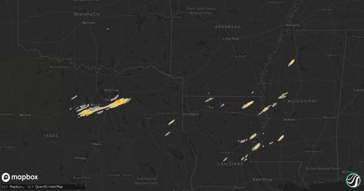
Hail Map in Louisiana on December 13, 2022
Get this storm
December 13 map
$229
one time, instant access
Download today. No call, no setup
Keep the $229
Bought the map and want the full workflow? Apply the entire $229 to a subscription within 7 days. None of it is wasted.
Every map, not just this one
This buys you this map. Subscription and you get every map we run, in the markets you choose from a few cities to whole states to nationwide. Plus real-time alerts the moment a storm fires.
Contact data
Name, contact info, occupancy, even credit band for addresses in the footprint. You go from where it hit to who to call.
Become the source they trust
Unlimited branding weather history reports on demand. You already have the documented answer ready for the property owner, and you are the one who showed up with it.
Property data and RoofTrace estimates
Pull up any address you have got, its value and the exact code rules for that jurisdiction, straight from One Click Code. Then RoofTrace estimates the squares, pitch, and roof value, priced the way you price.
Storm reports in Louisiana
Louisiana
| Date | Description |
|---|---|
| 12/13/20224:39 PM CST | *** 2 fatal *** corrects previous tornado report from 6 nw keachi. Manufactured / mobile homes completely destroyed on pecan road just nw of four forks near fullilove c |
| 12/13/20224:39 PM CST | Manufactured / mobile homes completely destroyed on pecan road just nw of four forks near fullilove cemetery. Forest mowed down in that area as well. |
| 12/13/20225:57 AM CST | At 1157 PM CST, a severe thunderstorm was located near Manifest, or 20 miles north of Larto, moving northeast at 35 mph. HAZARD...60 mph wind gusts and quarter size hail. SOURCE...Radar indicated. IMPACT...Hail damage to vehicles is expected. Expect wind damage to roofs, siding, and trees. This severe thunderstorm will be near... Jonesville and Manifest around 1205 AM CST. Wallace Ridge around 1215 AM CST.Other locations impacted by this severe thunderstorm includeHarrisonburg. |
| 12/13/20225:51 AM CST | At 1151 PM CST, a severe thunderstorm was located over Waverly, or 12 miles west of Tallulah, moving east at 35 mph. HAZARD...60 mph wind gusts. SOURCE...Radar indicated. IMPACT...Expect damage to roofs, siding, and trees. This severe thunderstorm will be near... Tallulah around 1210 AM CST. Mansford and Sondheimer around 1215 AM CST. Omega around 1220 AM CST. Eagle Bend around 1230 AM CST.Other locations impacted by this severe thunderstorm includeRichmond. |
| 12/13/20225:02 AM CST | At 1101 PM CST, a severe thunderstorm was located over Start, moving northeast at 50 mph. HAZARD...60 mph wind gusts. SOURCE...Radar indicated. IMPACT...Expect damage to roofs, siding, and trees. This severe thunderstorm will be near... Holly Ridge around 1110 PM CST. Warden around 1125 PM CST. Darnell around 1135 PM CST.Other locations impacted by this severe thunderstorm include Pioneerand Epps. |
| 12/13/20224:50 AM CST | At 1050 PM CST, a severe thunderstorm was located 8 miles west of Rolling Fork, moving northeast at 50 mph. HAZARD...60 mph wind gusts and quarter size hail. SOURCE...Radar indicated. IMPACT...Hail damage to vehicles is expected. Expect wind damage to roofs, siding, and trees. This severe thunderstorm will be near... Rolling Fork and Grace around 1100 PM CST. Anguilla and Nitta Yuma around 1105 PM CST. Panther Burn around 1110 PM CST. Hollandale and Delta City around 1115 PM CST. Murphy around 1120 PM CST.Other locations impacted by this severe thunderstorm includeMayersville. |
| 12/13/20224:21 AM CST | At 1020 PM CST, a severe thunderstorm was located 8 miles south of Natchitoches, moving northeast at 35 mph. HAZARD...60 mph wind gusts and quarter size hail. SOURCE...Radar indicated. IMPACT...Hail damage to vehicles is expected. Expect wind damage to roofs, siding, and trees. Locations impacted include... Natchitoches, Winnfield, Montgomery, Provencal, Natchez, Atlanta, Cloutierville, Melrose, Bellwood, St. Maurice, Flora, Lake Iatt, Cypress, Bermuda and Williana. |
| 12/13/20223:28 AM CST | At 928 PM CST, a severe thunderstorm was located over Rosefield, or 14 miles south of Columbia, moving northeast at 35 mph. HAZARD...60 mph wind gusts. SOURCE...Radar indicated. IMPACT...Expect damage to roofs, siding, and trees. This severe thunderstorm will be near... Enterprise around 935 PM CST. Jigger around 955 PM CST. Wisner around 1000 PM CST. Winnsboro around 1005 PM CST.Other locations impacted by this severe thunderstorm include Gilbert. |
| 12/13/20222:50 AM CST | At 849 PM CST, a severe thunderstorm was located near Huttig, moving northeast at 50 mph. HAZARD...60 mph wind gusts and quarter size hail. SOURCE...Radar indicated. IMPACT...Hail damage to vehicles is expected. Expect wind damage to roofs, siding, and trees. This severe thunderstorm will be near... West Crossett around 900 PM CST. Crossett and North Crossett around 905 PM CST. Berlin around 910 PM CST. Hamburg around 915 PM CST. Snyder around 930 PM CST. Portland and Montrose around 935 PM CST. |
| 12/12/202211:14 PM CST | Tornado observed at chotard lake. |
| 12/12/202210:56 PM CST | Tornado reported just north of i-20. |
| 12/12/202210:34 PM CST | Tornado continued ne for 11 minutes. Numerous trees were snapped or uprooted. Damage to a residence and several outbuildings. Damage to a large office supply building. |
| 12/12/202210:33 PM CST | Roof damage to camps near hunters bend. |
| 12/12/202210:25 PM CST | Structural damage to homes along la 610... Including a home with a tree that fell on it. |
| 12/12/202210:25 PM CST | Tornado continued ne for 4 minutes with numerous trees snapped or uprooted. Two houses and several outbuildings sustained damage. |
| 12/12/20228:35 PM CST | Quarter sized hail reported near ulm. |
| 12/12/20228:24 PM CST | Power lines down. |
| 12/12/20228:24 PM CST | Multiple mobile homes destroyed on camp rd in farmerville. Multiple injuries reported. |
| 12/12/20228:24 PM CST | Multiple mobile homes destroyed on camp rd in farmerville. |
All States Impacted by Hail Map on December 13, 2022
Cities Impacted by Hail Map on December 13, 2022
- Arlington, TX
- Fort Worth, TX
- Burleson, TX
- Mansfield, TX
- Kennedale, TX
- Granbury, TX
- Dubach, LA
- Bernice, LA
- Sicily Island, LA
- Konawa, OK
- Roxie, MS
- Enid, MS
- Oakland, MS
- Charleston, MS
- Parkdale, AR
- Homer, LA
- Athens, LA
- Clayton, LA
- Weatherford, TX
- Rockwall, TX
- Royse City, TX
- Terrell, TX
- Forney, TX
- Jonesville, LA
- Harrisonburg, LA
- Sondheimer, LA
- Mayersville, MS
- Natchez, MS
- Yazoo City, MS
- Marksville, LA
- Moreauville, LA
- Poolville, TX
- Winnsboro, LA
- Grand Prairie, TX
- Joshua, TX
- Cresson, TX
- Godley, TX
- Mesquite, TX
- Sunnyvale, TX
- Oak Ridge, LA
- Mer Rouge, LA
- Oak Grove, LA
- Dallas, TX
- Cedar Hill, TX
- Duncanville, TX
- Santo, TX
- Brookhaven, MS
- Quinlan, TX
- Seagoville, TX
- Balch Springs, TX
- Garrison, TX
- Rolling Fork, MS
- Wesson, MS
- Emerson, AR
- Tchula, MS
- Belzoni, MS
- Beckville, TX
- Carthage, TX
- Aledo, TX
- Lipan, TX
- Naval Air Station Jrb, TX
- Louise, MS
- Silver City, MS
- Lorman, MS
- Port Gibson, MS
- Lone Oak, TX
- Wills Point, TX
- Crowley, TX
- Lancaster, TX
- Point, TX
- Desoto, TX
- Hutchins, TX
- Lecompte, LA
- Forest Hill, LA
- Woodworth, LA
- Waterproof, LA
- Ferriday, LA
- Meadville, MS
- McCall Creek, MS
- Bastrop, LA
- Collinston, LA
- Haynesville, LA
- Vidalia, LA
- Jena, LA
- Hazlehurst, MS
- Valley Park, MS
- Midlothian, TX
- Venus, TX
- Tallulah, LA
- Vicksburg, MS
- Garland, TX
- Lavon, TX
- Rowlett, TX
- Nevada, TX
- Wylie, TX
- Mount Enterprise, TX
- Nacogdoches, TX
- Whitt, TX
- Perrin, TX
- Mineral Wells, TX
- Fort Necessity, LA
- Enterprise, LA
- Columbia, LA
- Shelbyville, TX
- Pickens, MS
- Lexington, MS
- Benton, MS
- Cruger, MS
- Georgetown, MS
- Harrisville, MS
- Decatur, TX
- Grapevine, TX
- Leonard, TX
- Wolfe City, TX
- Blue Ridge, TX
- Longview, TX
- Henderson, TX
- Marshall, TX
- Waskom, TX
- De Berry, TX
- Keatchie, LA
- Keithville, LA
- Farmerville, LA
- Marion, LA
- Terry, MS


