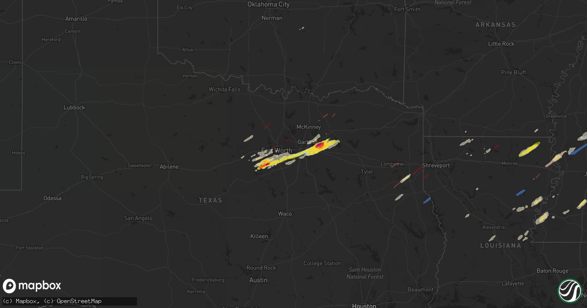
Hail Map on December 13, 2022
Get this storm
December 13 map
$229
one time, instant access
Download today. No call, no setup
Keep the $229
Bought the map and want the full workflow? Apply the entire $229 to a subscription within 7 days. None of it is wasted.
Every map, not just this one
This buys you this map. Subscription and you get every map we run, in the markets you choose from a few cities to whole states to nationwide. Plus real-time alerts the moment a storm fires.
Contact data
Name, contact info, occupancy, even credit band for addresses in the footprint. You go from where it hit to who to call.
Become the source they trust
Unlimited branding weather history reports on demand. You already have the documented answer ready for the property owner, and you are the one who showed up with it.
Property data and RoofTrace estimates
Pull up any address you have got, its value and the exact code rules for that jurisdiction, straight from One Click Code. Then RoofTrace estimates the squares, pitch, and roof value, priced the way you price.
States Impacted by Hail Map on December 13, 2022
Storm reports
Arkansas
| Date | Description |
|---|---|
| 12/13/20225:29 PM CST | Trees down near the intersection of highways 274 and 167. |
| 12/13/20224:04 AM CST | At 1004 PM CST, a severe thunderstorm was located near Portland, or 11 miles west of Eudora, moving northeast at 50 mph. HAZARD...60 mph wind gusts and quarter size hail. SOURCE...Radar indicated. IMPACT...Hail damage to vehicles is expected. Expect wind damage to roofs, siding, and trees. This severe thunderstorm will be near... Chicot Junction around 1015 PM CST. Lake Village around 1020 PM CST. Avon around 1030 PM CST. Wayside around 1035 PM CST. Greenville and Metcalfe around 1040 PM CST. Leland around 1045 PM CST. Tribbett around 1050 PM CST.Other locations impacted by this severe thunderstorm include Arcola. |
| 12/13/20222:21 AM CST | At 820 PM CST, a severe thunderstorm was located 8 miles southwest of Eudora, moving northeast at 55 mph. HAZARD...60 mph wind gusts and quarter size hail. SOURCE...Radar indicated. IMPACT...Hail damage to vehicles is expected. Expect wind damage to roofs, siding, and trees. This severe thunderstorm will be near... Eudora around 830 PM CST. Chicot Junction around 835 PM CST. Avon around 845 PM CST. Wayside around 850 PM CST. Greenville and Metcalfe around 900 PM CST. Leland and Tribbett around 905 PM CST.Other locations impacted by this severe thunderstorm includeKilbourne and Arcola. |
| 12/13/20221:37 AM CST | At 737 PM CST, a severe thunderstorm was located over Harrell, or near Hampton, moving northeast at 45 mph. HAZARD...60 mph wind gusts and quarter size hail. SOURCE...Radar indicated. IMPACT...Hail damage to vehicles is expected. Expect wind damage to roofs, siding, and trees. Locations impacted include... Monticello... Warren... Star City... Hampton... Hermitage... Wilmar... Harrell... Plantersville... Hampton Municipal Airport... Green Hill... Weeks... Brandon... Lanark... Herbine... Banks... Tinsman... Artesian... Carmel... Farmville... Cornerville... |
| 12/13/202212:02 AM CST | At 602 PM CST, a severe thunderstorm was located over Green Hill, or near Monticello, moving northeast at 60 mph. HAZARD...60 mph wind gusts and penny size hail. SOURCE...Radar indicated. IMPACT...Expect damage to roofs, siding, and trees. Locations impacted include... Monticello... Dumas... Star City... Gould... Gillett... Wilmar... Grady... Mitchellville... Tillar... Watson... Winchester... Whitefield... Plantersville... Little Bayou Meto Park... Woodville... Douglas... Trusten Holder WMA... Yancopin... Omega... Cane Creek State Park... |
| 12/12/202210:59 PM CST | At 459 PM CST, a severe thunderstorm was located over Cullendale, or near Camden, moving northeast at 45 mph. HAZARD...60 mph wind gusts and penny size hail. SOURCE...Radar indicated. IMPACT...Expect damage to roofs, siding, and trees. Locations impacted include... Camden... Fordyce... Hampton... Bearden... Thornton... Harrell... Cullendale... Ellisville... Harlow... Hampton Municipal Airport... Highland Industrial Park... Lanark... East Camden... Banks... Tinsman... Delhi... Harmony Grove... Frenchport... Elliot... Fairview in Ouachita County... |
| 12/12/202210:22 PM CST | At 421 PM CST, severe thunderstorms were located along a line extending from McNeil to Magnolia to near Macedonia, moving northeast at 45 mph. HAZARD...60 mph wind gusts. SOURCE...Radar indicated. IMPACT...Expect damage to roofs, siding, and trees. Locations impacted include... Camden... Hampton... Stephens... Louann... Cullendale... Highland Industrial Park... Hampton Municipal Airport... East Camden... Artesian... Delhi... Kirkland... Harmony Grove... Millers Bluff... Frenchport... Elliot... Cross Roads in Ouachita County... Fairview in Ouachita County... Troy... Locust Bayou... Warner... |
| 12/12/20229:47 PM CST | At 347 PM CST, severe thunderstorms were located along a line extending from Lewisville to near Canfield to 7 miles northwest of Plain Dealing, moving northeast at 55 mph. HAZARD...60 mph wind gusts and penny size hail. SOURCE...Radar indicated. IMPACT...Expect damage to roofs, siding, and trees. Locations impacted include... Magnolia, Stamps, Waldo, Lewisville, McNeil, Bradley, Taylor, Emerson, Buckner, Willisville, Bussey, Smithland, Atlanta, Canfield, Village, Macedonia, Welcome, Calhoun, Mount Vernon and Lerch. |
| 12/12/20228:53 PM CST | At 253 PM CST, severe thunderstorms were located along a line extending from near Fulton to near Garland to near Fouke to near Ida, moving northeast at 60 mph. HAZARD...60 mph wind gusts. SOURCE...Radar indicated. IMPACT...Expect damage to roofs, siding, and trees. Locations impacted include... Texarkana, Magnolia, Stamps, Waldo, Lewisville, McNeil, Fouke, Bradley, Buckner, Rosston, Garland, Willisville, Bodcaw, Bluff City, Bussey, Smithland, Genoa, Brightstar, Canfield and Macedonia. |
Louisiana
| Date | Description |
|---|---|
| 12/13/20224:39 PM CST | Manufactured / mobile homes completely destroyed on pecan road just nw of four forks near fullilove cemetery. Forest mowed down in that area as well. |
| 12/13/20224:39 PM CST | *** 2 fatal *** corrects previous tornado report from 6 nw keachi. Manufactured / mobile homes completely destroyed on pecan road just nw of four forks near fullilove c |
| 12/13/20225:57 AM CST | At 1157 PM CST, a severe thunderstorm was located near Manifest, or 20 miles north of Larto, moving northeast at 35 mph. HAZARD...60 mph wind gusts and quarter size hail. SOURCE...Radar indicated. IMPACT...Hail damage to vehicles is expected. Expect wind damage to roofs, siding, and trees. This severe thunderstorm will be near... Jonesville and Manifest around 1205 AM CST. Wallace Ridge around 1215 AM CST.Other locations impacted by this severe thunderstorm includeHarrisonburg. |
| 12/13/20225:51 AM CST | At 1151 PM CST, a severe thunderstorm was located over Waverly, or 12 miles west of Tallulah, moving east at 35 mph. HAZARD...60 mph wind gusts. SOURCE...Radar indicated. IMPACT...Expect damage to roofs, siding, and trees. This severe thunderstorm will be near... Tallulah around 1210 AM CST. Mansford and Sondheimer around 1215 AM CST. Omega around 1220 AM CST. Eagle Bend around 1230 AM CST.Other locations impacted by this severe thunderstorm includeRichmond. |
| 12/13/20225:02 AM CST | At 1101 PM CST, a severe thunderstorm was located over Start, moving northeast at 50 mph. HAZARD...60 mph wind gusts. SOURCE...Radar indicated. IMPACT...Expect damage to roofs, siding, and trees. This severe thunderstorm will be near... Holly Ridge around 1110 PM CST. Warden around 1125 PM CST. Darnell around 1135 PM CST.Other locations impacted by this severe thunderstorm include Pioneerand Epps. |
| 12/13/20224:50 AM CST | At 1050 PM CST, a severe thunderstorm was located 8 miles west of Rolling Fork, moving northeast at 50 mph. HAZARD...60 mph wind gusts and quarter size hail. SOURCE...Radar indicated. IMPACT...Hail damage to vehicles is expected. Expect wind damage to roofs, siding, and trees. This severe thunderstorm will be near... Rolling Fork and Grace around 1100 PM CST. Anguilla and Nitta Yuma around 1105 PM CST. Panther Burn around 1110 PM CST. Hollandale and Delta City around 1115 PM CST. Murphy around 1120 PM CST.Other locations impacted by this severe thunderstorm includeMayersville. |
| 12/13/20224:21 AM CST | At 1020 PM CST, a severe thunderstorm was located 8 miles south of Natchitoches, moving northeast at 35 mph. HAZARD...60 mph wind gusts and quarter size hail. SOURCE...Radar indicated. IMPACT...Hail damage to vehicles is expected. Expect wind damage to roofs, siding, and trees. Locations impacted include... Natchitoches, Winnfield, Montgomery, Provencal, Natchez, Atlanta, Cloutierville, Melrose, Bellwood, St. Maurice, Flora, Lake Iatt, Cypress, Bermuda and Williana. |
| 12/13/20223:28 AM CST | At 928 PM CST, a severe thunderstorm was located over Rosefield, or 14 miles south of Columbia, moving northeast at 35 mph. HAZARD...60 mph wind gusts. SOURCE...Radar indicated. IMPACT...Expect damage to roofs, siding, and trees. This severe thunderstorm will be near... Enterprise around 935 PM CST. Jigger around 955 PM CST. Wisner around 1000 PM CST. Winnsboro around 1005 PM CST.Other locations impacted by this severe thunderstorm include Gilbert. |
| 12/13/20222:50 AM CST | At 849 PM CST, a severe thunderstorm was located near Huttig, moving northeast at 50 mph. HAZARD...60 mph wind gusts and quarter size hail. SOURCE...Radar indicated. IMPACT...Hail damage to vehicles is expected. Expect wind damage to roofs, siding, and trees. This severe thunderstorm will be near... West Crossett around 900 PM CST. Crossett and North Crossett around 905 PM CST. Berlin around 910 PM CST. Hamburg around 915 PM CST. Snyder around 930 PM CST. Portland and Montrose around 935 PM CST. |
| 12/12/202211:14 PM CST | Tornado observed at chotard lake. |
| 12/12/202210:56 PM CST | Tornado reported just north of i-20. |
| 12/12/202210:34 PM CST | Tornado continued ne for 11 minutes. Numerous trees were snapped or uprooted. Damage to a residence and several outbuildings. Damage to a large office supply building. |
| 12/12/202210:33 PM CST | Roof damage to camps near hunters bend. |
| 12/12/202210:25 PM CST | Structural damage to homes along la 610... Including a home with a tree that fell on it. |
| 12/12/202210:25 PM CST | Tornado continued ne for 4 minutes with numerous trees snapped or uprooted. Two houses and several outbuildings sustained damage. |
| 12/12/20228:35 PM CST | Quarter sized hail reported near ulm. |
| 12/12/20228:24 PM CST | Power lines down. |
| 12/12/20228:24 PM CST | Multiple mobile homes destroyed on camp rd in farmerville. Multiple injuries reported. |
| 12/12/20228:24 PM CST | Multiple mobile homes destroyed on camp rd in farmerville. |
Oklahoma
| Date | Description |
|---|---|
| 12/13/20226:57 AM CST | At 1257 PM CST, a severe thunderstorm was located near Horatio, moving northeast at 60 mph. HAZARD...60 mph wind gusts and penny size hail. SOURCE...Radar indicated. IMPACT...Expect damage to roofs, siding, and trees. Locations impacted include... De Queen, Dierks, Horatio, Lockesburg, Winthrop, Corinth, Arkinda, Center Point, Oak Grove, Silver Ridge, Geneva, Central, Muddy Fork, Lebanon, Provo, West Line, Bellview, West Otis and Cerrogordo. |
| 12/13/202212:30 AM CST | At 629 AM CST, severe thunderstorms were located along a line extending from 5 miles northwest of Cromwell to near Wewoka to 5 miles northeast of Konawa, moving east at 35 mph. HAZARD...60 mph wind gusts. SOURCE...Radar indicated. IMPACT...Expect damage to roofs, siding, and trees. Locations impacted include... Seminole, Holdenville, Wewoka, Wetumka, Bowlegs, Cromwell, Horntown, Yeager, Little and Lima. |
| 12/12/202211:28 PM CST | At 527 AM CST, severe thunderstorms were located along a line extending from 3 miles southwest of Rosedale to 3 miles south of Foster, moving east at 30 mph. HAZARD...70 mph wind gusts. SOURCE...Radar indicated. IMPACT...Expect considerable tree damage. Damage is likely to mobile homes, roofs, and outbuildings. Locations impacted include... Pauls Valley, Wynnewood, Stratford, Konawa, Maysville, Elmore City, Paoli, Bowlegs, Asher, Wanette, Byars, Foster, St. Louis, Rosedale, Vanoss, Antioch, Pernell and Whitebead. |
| 12/12/202210:03 PM CST | At 403 AM CST, a severe thunderstorm was located near Temple, moving northeast at 40 mph. HAZARD...60 mph wind gusts. SOURCE...Radar indicated. IMPACT...Expect damage to roofs, siding, and trees. Locations impacted include... Duncan, Walters, Comanche, Temple, Velma, Corum, northwestern Waurika Lake and Empire City. |
| 12/12/20229:15 PM CST | At 315 AM CST, a severe thunderstorm was located near Iowa Park, moving northeast at 40 mph. HAZARD...60 mph wind gusts and quarter size hail. SOURCE...Radar indicated. IMPACT...Hail damage to vehicles is expected. Expect wind damage to roofs, siding, and trees. Locations impacted include... Northwestern Wichita Falls, Burkburnett, Iowa Park, Temple, Randlett, Sheppard AFB, Pleasant Valley, Taylor, Charlie and Cashion. |
| 12/12/20228:28 PM CST | At 228 AM CST, a severe thunderstorm was located near Hitchcock, moving northeast at 55 mph. HAZARD...60 mph wind gusts and penny size hail. SOURCE...Radar indicated. IMPACT...Expect damage to roofs, siding, and trees. Locations impacted include... Hennessey, Waukomis, Dover, Hitchcock, Loyal, Bison, Omega and Lacey. |
| 12/12/20228:01 PM CST | At 200 AM CST, severe thunderstorms were located along a line extending from 4 miles south of Tipton to near Oklaunion to 4 miles north of Lake Kemp, moving northeast at 45 mph. HAZARD...60 mph wind gusts and penny size hail. SOURCE...Radar indicated. IMPACT...Expect damage to roofs, siding, and trees. Locations impacted include... Frederick, Cache, Electra, Snyder, Grandfield, Chattanooga, Mountain Park, Indiahoma, Davidson, Manitou, Hollister, Loveland, Tom Steed Reservoir, Harrold, Lake Kemp, Oklaunion, Grayback, southwestern Fort Sill, Wichita Mountains Wildlife Refuge and Haynesville. |
| 12/12/20227:52 PM CST | At 152 AM CST, severe thunderstorms were located along a line extending from near Canton Lake to near Fay to 5 miles west of Weatherford, moving northeast at 55 mph. HAZARD...70 mph wind gusts and penny size hail. SOURCE...Radar indicated. IMPACT...Expect considerable tree damage. Damage is likely to mobile homes, roofs, and outbuildings. Locations impacted include... Weatherford, Watonga, Okeene, Thomas, Canton, Lahoma, Drummond, Longdale, Ames, Hitchcock, Greenfield, Loyal, Oakwood, Canton Lake, Eagle City, Isabella, Fay, Homestead, Southard and Omega. |
| 12/12/20227:18 PM CST | At 118 AM CST, severe thunderstorms were located along a line extending from 5 miles northeast of Cestos to 4 miles northwest of Putnam to 6 miles west of Clinton to 5 miles north of Sentinel, moving northeast at 65 mph. HAZARD...60 mph wind gusts. SOURCE...Radar indicated. IMPACT...Expect damage to roofs, siding, and trees. Locations impacted include... Clinton, Taloga, Burns Flat, Thomas, Seiling, Arapaho, Dill City, Canute, Custer City, Butler, Bessie, Foss, Oakwood, Mutual, Putnam, Foss Reservoir, Quinlan, Orion, Chester and Cestos. |
Mississippi
| Date | Description |
|---|---|
| 12/13/20225:44 AM CST | Storm chaser reported tree branches down off hwy 28 and trees down on the roadway due to confirmed tornado. |
| 12/13/20225:34 AM CST | Mobile homes destroyed in sharkey county. |
| 12/13/20225:34 AM CST | *** 3 inj *** corrects previous tornado report from anguilla. Mobile homes destroyed in sharkey county. |
| 12/13/20225:25 AM CST | Emergency manager reported trees and power lines down on hwy 15 south at ed crowder rd due to possible tornado. |
| 12/13/20225:18 AM CST | Emergency manager reported tree top down at tank rd and terry rd due to possible tornado. Was raining sideways at 5:29 am. |
| 12/13/20225:16 AM CST | At 1116 PM CST, a severe thunderstorm was located over Burgess, or 9 miles west of Holly Springs National Forest, moving northeast at 65 mph. HAZARD...60 mph wind gusts. SOURCE...Radar indicated. IMPACT...Expect damage to roofs, siding, and trees. Locations impacted include... Oxford, Water Valley, Holly Springs National Forest, Cambridge, Etta, Springdale, Burgess, Bethlehem, Denmark, Pinedale, Thaxton, Potts Camp, Abbeville, Taylor, Malone, Keel, Esperanza, Waterford, Lake Center and College Hill Station. |
| 12/13/20225:14 AM CST | At 1114 PM CST, a severe thunderstorm was located over Indianola, moving northeast at 50 mph. HAZARD...60 mph wind gusts and quarter size hail. SOURCE...Radar indicated. IMPACT...Hail damage to vehicles is expected. Expect wind damage to roofs, siding, and trees. This severe thunderstorm will be near... Moorhead around 1120 PM CST. Sunflower around 1125 PM CST. Blaine around 1130 PM CST. Itta Bena around 1135 PM CST. Sunnyside around 1145 PM CST. Minter City and Money around 1150 PM CST.Other locations impacted by this severe thunderstorm includeSchlater. |
| 12/13/20223:55 AM CST | Emergency manager reported small debris on liberty rd. 8 residents were reported trapped inside a home on 24 nations rd... Cranfield area in adams county. First respond |
| 12/13/20223:42 AM CST | At 942 PM CST, a severe thunderstorm was located over Shaw, moving northeast at 40 mph. HAZARD...60 mph wind gusts. SOURCE...Radar indicated. IMPACT...Expect damage to roofs, siding, and trees. This severe thunderstorm will be near... Shaw around 945 PM CST. Cleveland and Boyle around 955 PM CST. Ruleville around 1005 PM CST. Drew around 1015 PM CST.Other locations impacted by this severe thunderstorm includeDoddsville. |
| 12/13/202212:09 AM CST | Tornado sighted near lake albemarle. |
| 12/12/202211:31 PM CST | Large transmission lines downed across us 61 and a home damaged east of us 61. |
| 12/12/202211:11 PM CST | Large tree uprooted... Several structures destroyed... Large tree limbs down. |
Texas
| Date | Description |
|---|---|
| 12/13/20224:08 PM CST | Damage at old town road and 451 north of de berry. Large outbuilding damaged - several trees shredded. Fire clearing trees off of 451 just east of old town. |
| 12/13/20223:45 PM CST | Corrects previous tornado report from 9 sw waskom. Damage at old town road and 451 north of de berry. Large outbuilding damaged - several trees shredded. Fire clearing |
| 12/13/202212:20 PM CST | Trees were downed and mobile home covers were damaged along cr 317 just south of fm 16. Fences and telephone poles were snapped. |
| 12/13/202210:54 AM CST | Confirmed structure damage 5 w of paris. |
| 12/13/202210:22 AM CST | Trained spotter reports 1.5 inch hail 5 miles se of fate... Tx. |
| 12/13/202210:13 AM CST | Reports of tennis ball sized hail |
| 12/13/202210:07 AM CST | Trained spotter report of quarter sized hail in heath. |
| 12/13/202210:00 AM CST | *** 1 inj *** reports of structure damage near hwy 69 wsw of leonard. |
| 12/13/202210:00 AM CST | Reports of travel trailer overturned and damaged homes near fm 816 in wolfe city. |
| 12/13/202210:00 AM CST | Reports of tree damage near blue ridge. |
| 12/13/20229:58 AM CST | *** 1 inj *** reports of homes damaged sw of leonard |
| 12/13/20229:55 AM CST | Trained spotter reported structure damage 5 miles wsw of leonard... Tx. |
| 12/13/20229:50 AM CST | Reports of damage to mobile home |
| 12/13/20229:32 AM CST | 54.0 kt wind gust measured at dallas/redbird arpt...tx |
| 12/13/20229:20 AM CST | Trained spotter reported quarter sized hail 1 miles s of duncanville... Tx. |
| 12/13/20229:10 AM CST | Spotter report of quarter |
| 12/13/20229:10 AM CST | Photo of damage at shopping center in plano. Time estimated. |
| 12/13/20229:01 AM CST | Report of quarter |
| 12/13/20228:49 AM CST | Trained spotter reported damage to commercial building on the west side of grapevine. |
| 12/13/20228:46 AM CST | Video of large... Metal outbuilding blown onto road along hwy 174 s of cleburne. |
| 12/13/20228:46 AM CST | *** 5 inj *** photos of damage to buildings and commercial businesses near grapevine mills on social media. Damage starts back at sams club in grapevine. |
| 12/13/20228:43 AM CST | Corrects previous tornado report from 1 wnw grapevine. Video shows tornado crossing w state hwy 114 near the hospital wnw of grapevine. Time estimated from radar. |
| 12/13/20228:41 AM CST | Corrects previous tornado report from 1 wnw grapevine. Corrects previous tornado report from 1 wnw grapevine. Video shows tornado crossing w state hwy 114 near the hosp |
| 12/13/20228:24 AM CST | Roof damage at commercial business north of north richland hills. Time estimated from radar. |
| 12/13/20228:22 AM CST | Photos of damage to the walls of a hangar and planes at an airport in n ft worth shared on social media. |
| 12/13/20228:19 AM CST | Picture shared of 2 inch hail nw of godley. |
| 12/13/20228:14 AM CST | Nws survey confirms ef1 at marion sansom park in fort worth. Tornado travelled northeast... Causing damage mainly to trees. |
| 12/13/20228:11 AM CST | Nws survey confirms ef0 tornado began at one of the aircraft hangars and continued to the east/northeast dissipating near the food court at nas jrb. |
| 12/13/20228:10 AM CST | Nws survey confirms ef0 tornado near the air traffic control tower at nas jrb. |
| 12/13/20227:45 AM CST | Video of structure damage sw of tolar. |
| 12/13/20227:39 AM CST | Photos of damage to houses and tree damage wnw of callisburg. |
| 12/13/20227:37 AM CST | Reports of damage to several homes and trees near and northeast of fm 371/cr122. Time estimated from radar. |
| 12/13/20227:24 AM CST | Reports of damage to awnings of apartment complex in hudson oaks and tree damage in the area. |
| 12/13/20227:18 AM CST | Reports of multiple 18 wheelers flipped over near i-20 and dennis road. Video of tree damage on social media. |
| 12/13/20227:13 AM CST | Reports of damage to commercial buildings north of i-20 wsw of weatherford. |
| 12/13/20227:10 AM CST | Report of overturned semi on 287 in decatur. |
| 12/13/20227:08 AM CST | Report of 18 wheelers blown over at i-20 and brock hwy. |
| 12/13/20226:47 AM CST | Reports of structure damage and tree damage s of i-20 in santo... Tx. |
| 12/13/20225:31 AM CST | At 1131 AM CST, severe thunderstorms were located along a line extending from 6 miles east of Blossom to near Deport to 10 miles east of Cooper Lake Park South Sulphur to 6 miles west of Como to near Emory, moving east at 25 mph. HAZARD...60 mph wind gusts and quarter size hail. SOURCE...Radar indicated. IMPACT...Hail damage to vehicles is expected. Expect wind damage to roofs, siding, and trees. Locations impacted include... Mount Pleasant, Winnsboro, Clarksville, Hagansport, Boxelder, Mount Vernon, Quitman, Bogata, Scroggins, Pleasant Grove, Hainesville, Golden, Wilkerson, Bagwell, Newsome, Purley, Forest Hill, Detroit, Winfield and Talco. |
| 12/13/20225:24 AM CST | At 1124 AM CST, severe thunderstorms were located along a line extending from near Pattonville to near East Tawakoni, moving east at 40 mph. HAZARD...60 mph wind gusts and quarter size hail. SOURCE...Radar indicated. IMPACT...Hail damage to vehicles is expected. Expect wind damage to roofs, siding, and trees. Locations impacted include... Sulphur Springs, Blossom, Emory, Como, Pattonville, Lake Sulphur Springs, Cooper Lake State Park, Lake Fork Reservoir, Deport, Pine Forest, Tira, New Birthright, Pacio, Minter, Taylor Town, Nelta, Cunningham, Dike, Martin Springs and Weaver.This includes Interstate 30 between mile markers 118 and 142. |
| 12/13/20224:29 AM CST | At 1028 AM CST, severe thunderstorms were located along a line extending from near Honey Grove to Greenville Club Lake, moving east at 55 mph. HAZARD...60 mph wind gusts and half dollar size hail. SOURCE...Radar indicated. IMPACT...Hail damage to vehicles is expected. Expect wind damage to roofs, siding, and trees. Locations impacted include... Greenville, Paris, Sulphur Springs, Commerce, Cooper, West Tawakoni, Blossom, Wolfe City, Quinlan, Emory, East Tawakoni, Point, Cumby, Como, Roxton, Campbell, Hawk Cove, Lake Tawakoni, Cooper Lake and Greenville Club Lake.This includes Interstate 30 between mile markers 89 and 140. |
| 12/13/20223:54 AM CST | At 954 AM CST, a severe thunderstorm was located over Balch Springs, moving east at 35 mph. HAZARD...60 mph wind gusts and half dollar size hail. SOURCE...Radar indicated. IMPACT...Hail damage to vehicles is expected. Expect wind damage to roofs, siding, and trees. Locations impacted include... Dallas, Garland, Mesquite, Rowlett, Wylie, Rockwall, Balch Springs, Sachse, Terrell, Seagoville, Forney, Kaufman, Royse City, Heath, Fate, Sunnyvale, Wilmer, Crandall, Ferris and Combine.This includes the following highways... Interstate 20 between mile markers 478 and 512. Interstate 30 between mile markers 59 and 83. Interstate 45 between mile markers 267 and 269. |
| 12/13/20223:35 AM CST | At 934 AM CST, a severe thunderstorm was located over Lowry Crossing, or near McKinney, moving northeast at 40 mph. HAZARD...60 mph wind gusts and penny size hail. SOURCE...Radar indicated. IMPACT...Expect damage to roofs, siding, and trees. Locations impacted include... McKinney, Allen, Wylie, Greenville, Commerce, Royse City, Fairview, Princeton, Lucas, Melissa, Farmersville, Leonard, Lowry Crossing, Honey Grove, Wolfe City, Caddo Mills, Celeste, Campbell, Trenton and Dodd City.This includes Interstate 30 between mile markers 89 and 101. |
| 12/13/20223:09 AM CST | At 909 AM CST, a severe thunderstorm was located near Mansfield, moving east at 45 mph. HAZARD...60 mph wind gusts and quarter size hail. SOURCE...Radar indicated. IMPACT...Hail damage to vehicles is expected. Expect wind damage to roofs, siding, and trees. Locations impacted include... Grand Prairie, Mansfield, Cedar Hill, Lancaster, Waxahachie, Ennis, Midlothian, Glenn Heights, Red Oak, Ovilla, Venus, Ferris, Palmer, Oak Leaf, Bristol, Pecan Hill, Ike, Rockett, India and Trumbull.This includes the following highways... Interstate 35E between mile markers 399 and 411. Interstate 45 between mile markers 257 and 266. |
| 12/13/20222:50 AM CST | At 850 AM CST, a severe thunderstorm was located over Kennedale, moving east at 30 mph. HAZARD...60 mph wind gusts and quarter size hail. SOURCE...Radar indicated. IMPACT...Hail damage to vehicles is expected. Expect wind damage to roofs, siding, and trees. Locations impacted include... Dallas, Fort Worth, Arlington, Garland, Irving, Grand Prairie, Mesquite, Mansfield, Rowlett, Desoto, Cedar Hill, Duncanville, Lancaster, Balch Springs, University Park, Seagoville, Forest Hill, Glenn Heights, Highland Park and Kennedale.This includes the following highways... Interstate 35E between mile markers 412 and 433. Interstate 20 between mile markers 439 and 485. Interstate 30 between mile markers 25 and 64. Interstate 45 between mile markers 267 and 284. |
| 12/13/20222:45 AM CST | At 844 AM CST, a severe thunderstorm was located over DFW Intl Airport, or over Grapevine, moving northeast at 40 mph. HAZARD...60 mph wind gusts and nickel size hail. SOURCE...Radar indicated. IMPACT...Expect damage to roofs, siding, and trees. Locations impacted include... Dallas, Plano, Garland, Irving, Grand Prairie, McKinney, Carrollton, Frisco, Richardson, Lewisville, Allen, Flower Mound, Rowlett, Euless, Grapevine, Wylie, Coppell, The Colony, Farmers Branch and University Park.This includes Interstate 35E between mile markers 433 and 454. |
| 12/13/20222:13 AM CST | At 813 AM CST, a severe thunderstorm was located near Godley, or 9 miles east of Granbury, moving east at 30 mph. HAZARD...60 mph wind gusts and nickel size hail. SOURCE...Radar indicated. IMPACT...Expect damage to roofs, siding, and trees. Locations impacted include... Mansfield, Burleson, Cleburne, Crowley, Granbury, Keene, Joshua, Alvarado, Rendon, Pecan Plantation, Venus, Godley, Cross Timber, DeCordova, Cresson, Briaroaks, Coyote Flats, Egan, Lillian and Acton.This includes Interstate 35W between mile markers 23 and 37. |
| 12/13/20222:06 AM CST | At 806 AM CST, a severe thunderstorm was located over southwestern Lake Texoma, moving northeast at 40 mph. HAZARD...60 mph wind gusts. SOURCE...Radar indicated. IMPACT...Expect damage to roofs, siding, and trees. Locations impacted include... Durant, Kingston, Colbert, Silo, Kenefic, Mead, Armstrong, Cartwright, Blue, Woodville, Willis, Little City, Nida, Lake Texoma, Calera and Mcbride. |
| 12/13/20221:45 AM CST | At 745 AM CST, a severe thunderstorm was located over Annetta, or 7 miles southeast of Weatherford, moving east at 35 mph. HAZARD...60 mph wind gusts and nickel size hail. SOURCE...Radar indicated. IMPACT...Expect damage to roofs, siding, and trees. Locations impacted include... Fort Worth, Arlington, Irving, Grand Prairie, Mansfield, Euless, Bedford, Grapevine, Haltom City, Hurst, Burleson, Weatherford, Watauga, Colleyville, Benbrook, Saginaw, White Settlement, Crowley, Forest Hill and Richland Hills.This includes the following highways... Interstate 35W between mile markers 38 and 59. Interstate 20 between mile markers 413 and 453. Interstate 30 between mile markers 1 and 31. |
| 12/12/202211:07 PM CST | At 507 AM CST, severe thunderstorms were located along a line extending from 7 miles southwest of Loco to 6 miles southeast of Petrolia, moving east at 45 mph. HAZARD...60 mph wind gusts and quarter size hail. SOURCE...Radar indicated. IMPACT...Hail damage to vehicles is expected. Expect wind damage to roofs, siding, and trees. Locations impacted include... Davis, Waurika, Healdton, Wilson, Ringling, Ryan, Petrolia, Loco, Ratliff City, Addington, Sugden, Graham, Pooleville, Milo, southeastern Waurika Lake, Cornish and Fox. |
| 12/12/202211:00 PM CST | At 459 AM CST, a severe thunderstorm was located near Rising Star, or 14 miles south of Cisco, moving northeast at 35 mph. HAZARD...60 mph wind gusts and quarter size hail. SOURCE...Radar indicated. IMPACT...Hail damage to vehicles is expected. Expect wind damage to roofs, siding, and trees. Locations impacted include... Eastland, Ranger, Gorman, Rising Star, Lake Olden, Lake Leon, Pleasant Hill, Carbon, Staff, Nimrod, Kokomo, Sabanno, Okra, Pioneer, Olden and Desdemona.This includes Interstate 20 between mile markers 333 and 362. |
| 12/12/202210:50 PM CST | At 449 PM CST, a severe thunderstorm was located near Austonio, moving northeast at 30 mph. HAZARD...60 mph wind gusts and penny size hail. SOURCE...Radar indicated. IMPACT...Expect damage to roofs, siding, and trees. Locations impacted include... Crockett, Austonio, Grapeland and Latexo. |
| 12/12/20229:55 PM CST | At 354 PM CST, a severe thunderstorm was located over Mont Belvieu, or 10 miles east of Barrett, moving northeast at 30 mph. HAZARD...60 mph wind gusts and penny size hail. SOURCE...Radar indicated. IMPACT...Expect damage to roofs, siding, and trees. Locations impacted include... Liberty, Dayton, Mont Belvieu, Old River-Winfree, Ames, Daisetta, Hardin, Kenefick, Devers and Dayton Lakes. |
| 12/12/20229:41 PM CST | At 341 PM CST, a severe thunderstorm was located near West Livingston, or near Livingston, moving northeast at 35 mph. HAZARD...60 mph wind gusts and penny size hail. SOURCE...Radar indicated. IMPACT...Expect damage to roofs, siding, and trees. Locations impacted include... Livingston, Onalaska, Corrigan, Seven Oaks, northeastern West Livingston, Leggett and Moscow. |
| 12/12/20229:31 PM CST | At 331 AM CST, a severe thunderstorm was located 7 miles southeast of Lake Kickapoo, moving northeast at 35 mph. HAZARD...60 mph wind gusts and quarter size hail. SOURCE...Radar indicated. IMPACT...Hail damage to vehicles is expected. Expect wind damage to roofs, siding, and trees. Locations impacted include... Archer City, Scotland, Windthorst and southwestern Lake Arrowhead. |
| 12/12/20229:17 PM CST | At 317 PM CST, a severe thunderstorm was located over Diboll, moving northeast at 40 mph. HAZARD...60 mph wind gusts and quarter size hail. SOURCE...Radar indicated. IMPACT...Hail damage to vehicles is expected. Expect wind damage to roofs, siding, and trees. Locations impacted include... Lufkin, Nacogdoches, Diboll, Hudson, Huntington, Woden, Burke, Redland and Homer. |
| 12/12/20229:02 PM CST | At 302 PM CST, a severe thunderstorm was located over Smithland, or 18 miles south of Atlanta, moving east at 45 mph. HAZARD...60 mph wind gusts and quarter size hail. SOURCE...Radar indicated. IMPACT...Hail damage to vehicles is expected. Expect wind damage to roofs, siding, and trees. Locations impacted include... Vivian, Plain Dealing, Bradley, Hosston, Rodessa, Ida, Gilliam, Smithland, McLeod, Gray and Bolinger. |
| 12/12/20228:43 PM CST | At 243 PM CST, a severe thunderstorm was located over Forest, or 20 miles south of Rusk, moving northeast at 45 mph. HAZARD...60 mph wind gusts and quarter size hail. SOURCE...Radar indicated. IMPACT...Hail damage to vehicles is expected. Expect wind damage to roofs, siding, and trees. Locations impacted include... Alto, Wells, Morrill, Sacul, Forest, Douglass, Trawick, Cushing, Reklaw, Lilbert, Linwood and Looneyville. |
| 12/12/20228:39 PM CST | At 238 AM CST, a severe thunderstorm was located 4 miles east of Mabelle, moving northeast at 35 mph. HAZARD...60 mph wind gusts and quarter size hail. SOURCE...Radar indicated. IMPACT...Hail damage to vehicles is expected. Expect wind damage to roofs, siding, and trees. Locations impacted include... Wichita Falls, Iowa Park, Holliday, Mabelle, Sheppard AFB, Lake Diversion, Dundee, Mankins, Lakeside City, Pleasant Valley and Cashion. |
| 12/12/20228:32 PM CST | At 231 AM CST, severe thunderstorms were located along a line extending from 3 miles northwest of Meers to 4 miles northwest of Faxon to 4 miles southeast of Electra, moving east at 45 mph. HAZARD...70 mph wind gusts. SOURCE...Radar indicated. IMPACT...Expect considerable tree damage. Damage is likely to mobile homes, roofs, and outbuildings. Locations impacted include... Northwestern Wichita Falls, Lawton, Duncan, Burkburnett, Marlow, Walters, Iowa Park, Cache, Electra, Elgin, Comanche, Geronimo, Rush Springs, Fletcher, Grandfield, Temple, Sterling, Byers, Chattanooga and Randlett. |
| 12/12/20228:23 PM CST | At 222 PM CST, a severe thunderstorm was located near Kennard, or 16 miles northeast of Crockett, moving northeast at 40 mph. HAZARD...Quarter size hail. SOURCE...Radar indicated. IMPACT...Damage to vehicles is expected. Locations impacted include... Grapeland, Kennard, Latexo and Weches. |
Cities Impacted by Hail Map on December 13, 2022
- Arlington, TX
- Fort Worth, TX
- Burleson, TX
- Mansfield, TX
- Kennedale, TX
- Granbury, TX
- Dubach, LA
- Bernice, LA
- Sicily Island, LA
- Konawa, OK
- Roxie, MS
- Enid, MS
- Oakland, MS
- Charleston, MS
- Parkdale, AR
- Homer, LA
- Athens, LA
- Clayton, LA
- Weatherford, TX
- Rockwall, TX
- Royse City, TX
- Terrell, TX
- Forney, TX
- Jonesville, LA
- Harrisonburg, LA
- Sondheimer, LA
- Mayersville, MS
- Natchez, MS
- Yazoo City, MS
- Marksville, LA
- Moreauville, LA
- Poolville, TX
- Winnsboro, LA
- Grand Prairie, TX
- Joshua, TX
- Cresson, TX
- Godley, TX
- Mesquite, TX
- Sunnyvale, TX
- Oak Ridge, LA
- Mer Rouge, LA
- Oak Grove, LA
- Dallas, TX
- Cedar Hill, TX
- Duncanville, TX
- Santo, TX
- Brookhaven, MS
- Quinlan, TX
- Seagoville, TX
- Balch Springs, TX
- Garrison, TX
- Rolling Fork, MS
- Wesson, MS
- Emerson, AR
- Tchula, MS
- Belzoni, MS
- Beckville, TX
- Carthage, TX
- Aledo, TX
- Lipan, TX
- Naval Air Station Jrb, TX
- Louise, MS
- Silver City, MS
- Lorman, MS
- Port Gibson, MS
- Lone Oak, TX
- Wills Point, TX
- Crowley, TX
- Lancaster, TX
- Point, TX
- Desoto, TX
- Hutchins, TX
- Lecompte, LA
- Forest Hill, LA
- Woodworth, LA
- Waterproof, LA
- Ferriday, LA
- Meadville, MS
- McCall Creek, MS
- Bastrop, LA
- Collinston, LA
- Haynesville, LA
- Vidalia, LA
- Jena, LA
- Hazlehurst, MS
- Valley Park, MS
- Midlothian, TX
- Venus, TX
- Tallulah, LA
- Vicksburg, MS
- Garland, TX
- Lavon, TX
- Rowlett, TX
- Nevada, TX
- Wylie, TX
- Mount Enterprise, TX
- Nacogdoches, TX
- Whitt, TX
- Perrin, TX
- Mineral Wells, TX
- Fort Necessity, LA
- Enterprise, LA
- Columbia, LA
- Shelbyville, TX
- Pickens, MS
- Lexington, MS
- Benton, MS
- Cruger, MS
- Georgetown, MS
- Harrisville, MS
- Decatur, TX
- Grapevine, TX
- Leonard, TX
- Wolfe City, TX
- Blue Ridge, TX
- Longview, TX
- Henderson, TX
- Marshall, TX
- Waskom, TX
- De Berry, TX
- Keatchie, LA
- Keithville, LA
- Farmerville, LA
- Marion, LA
- Terry, MS