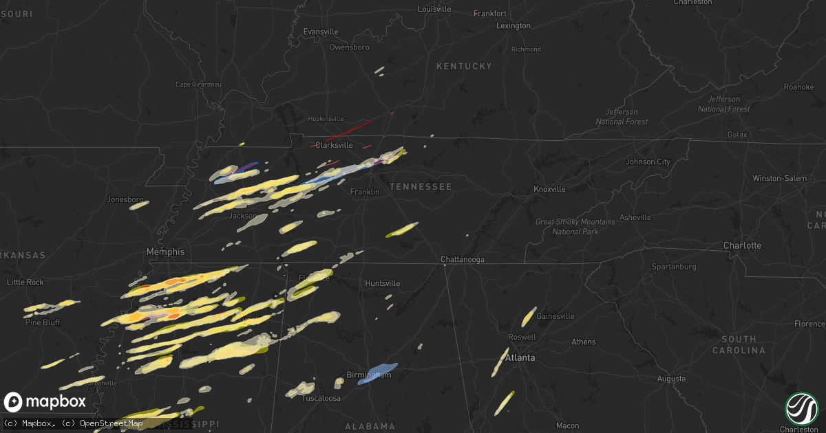
Hail Map in Tennessee on December 9, 2023
Get this storm
December 9 map
$229
one time, instant access
Download today. No call, no setup
Keep the $229
Bought the map and want the full workflow? Apply the entire $229 to a subscription within 7 days. None of it is wasted.
Every map, not just this one
This buys you this map. Subscription and you get every map we run, in the markets you choose from a few cities to whole states to nationwide. Plus real-time alerts the moment a storm fires.
Contact data
Name, contact info, occupancy, even credit band for addresses in the footprint. You go from where it hit to who to call.
Become the source they trust
Unlimited branding weather history reports on demand. You already have the documented answer ready for the property owner, and you are the one who showed up with it.
Property data and RoofTrace estimates
Pull up any address you have got, its value and the exact code rules for that jurisdiction, straight from One Click Code. Then RoofTrace estimates the squares, pitch, and roof value, priced the way you price.
Storm reports in Tennessee
Tennessee
| Date | Description |
|---|---|
| 12/09/20235:50 PM CST | Estimated quarter size hail 1 mile north of tn-25 and us-231. |
| 12/09/20235:18 PM CST | Damage reported in castilian springs. Time estimated by radar. |
| 12/09/20235:15 PM CST | Awos station kxnx gallatin airport. |
| 12/09/20235:09 PM CST | Reports of damage on southern side of gallatin. Time estimated by radar and tornado debris signature. |
| 12/09/20234:51 PM CST | Cars flipped on i65. |
| 12/09/20234:50 PM CST | Damage reported... Tornado debris signature on radar as well. |
| 12/09/20234:46 PM CST | Tornado damage reported. Time estimated on radar. Debris signature on radar. |
| 12/09/20234:22 PM CST | Tornado ongoing in springfield. |
| 12/09/20234:21 PM CST | Damage to industrial area. |
| 12/09/20234:03 PM CST | Tornado with debris signature began near this area and tracked across cheatham county into western davidson county. |
| 12/09/20233:57 PM CST | Estimated hail size from social media picture. Time estimated on radar. |
| 12/09/20233:32 PM CST | Damage reported in northern part of dickson county. Time and location estimated from tornado debris signature on radar. |
| 12/09/20233:21 PM CST | A local report indicates 1.00 inch wind near 8 S Camden |
| 12/09/20232:25 PM CST | Half-dollar sized hail off of flatwoods rd. |
| 12/09/20232:20 PM CST | A local report indicates 1.00 inch wind near Camden |
| 12/09/20232:06 PM CST | A local report indicates 1.00 inch wind near Hollow Rock |
| 12/09/20232:00 PM CST | Tornado crossed into kentucky around this location. |
| 12/09/20231:55 PM CST | A local report indicates 1.50 inch wind near Huntingdon |
| 12/09/20231:52 PM CST | Half-dollar size hail in the three way area. |
| 12/09/20231:51 PM CST | Tornado continues across northern portions of clarksville... Tn. |
| 12/09/20231:45 PM CST | Quarter to ping-pong ball sized hail along highway 79. |
| 12/09/20231:43 PM CST | Webcam shows tornado and many reports. First observed debris on radar here. |
| 12/09/20231:36 PM CST | A local report indicates 1.00 inch wind near Atwood |
| 12/09/20231:30 PM CST | A local report indicates 1.75 inch wind near Milan |
| 12/09/20231:24 PM CST | Powerlines down and debris in the road on red top road north of indian mound. Debris signature was noted on radar. Time estimated by radar. |
| 12/09/20231:12 PM CST | Corrects previous hail report from 2 se nutbush. |
| 12/09/202312:05 PM CST | Large trees along chicken road. |
| 12/09/202312:04 PM CST | Structural damage to the national guard armory. |
| 12/09/202312:02 PM CST | Trees and powerlines down south of dresden. |
| 12/09/202311:38 AM CST | Significant damage to the fire station north of rutherford. |
| 12/08/202311:13 PM CST | Tree down blocking a lane of traffic near mine rd and old rutledge pike. |
| 12/08/202310:45 PM CST | Multiple trees down at the intersection of live oak ln and stone rd. |
| 12/08/202310:40 PM CST | Powerlines down at 1200 block of east elmwood drive. |
| 12/08/20238:12 PM CST | Photo received of quarter-sized hail along riley creek road between normandy lake and tullahoma. Time is radar estimated. |
| 12/08/20238:12 PM CST | A few trees down along normandy road. Time is radar estimated. |
| 12/08/20238:05 PM CST | A tree was knocked down at 642 pierce hollow road. Time estimated by radar. |
| 12/08/20237:59 PM CST | A tree was knocked down into the road at the intersection of winchester road and cobb hollow road. Time estimated by radar. |
| 12/08/20237:59 PM CST | A tree was knocked down into the road at the intersection of winchester highway and norman wiseman road. Time estimated by radar. |
| 12/08/20237:55 PM CST | Power lines were knocked down into the road at 110 five points road. Time estimated by radar. |
| 12/08/20236:43 PM CST | Tree down on car on 1100 block of lexington highway southeast of loretto. |
| 12/08/20236:01 PM CST | Tree down in yard of home reported by tennessee valley weather. Location and time estimated. |
All States Impacted by Hail Map on December 9, 2023
Cities Impacted by Hail Map on December 9, 2023
- Fulton, KY
- Kenton, TN
- Trimble, TN
- Newbern, TN
- Dyersburg, TN
- Dyer, TN
- Rutherford, TN
- Greenfield, TN
- Sharon, TN
- Dresden, TN
- Gleason, TN
- Humphrey, AR
- Stuttgart, AR
- Humboldt, TN
- Trenton, TN
- Milan, TN
- Indian Mound, TN
- Woodlawn, TN
- Lavinia, TN
- Atwood, TN
- Brownsville, TN
- Bells, TN
- Gadsden, TN
- Clarksville, TN
- Trezevant, TN
- Huntingdon, TN
- McKenzie, TN
- Trenton, KY
- Guthrie, KY
- Tunica, MS
- Coldwater, MS
- Sarah, MS
- Camden, TN
- Hollow Rock, TN
- Bruceton, TN
- Buena Vista, TN
- Senatobia, MS
- Warren, AR
- Wilmar, AR
- Monticello, AR
- Mellwood, AR
- Crumrod, AR
- Clarksdale, MS
- Allensville, KY
- Olmstead, KY
- Russellville, KY
- Medina, TN
- Hernando, MS
- Dundee, MS
- Lyon, MS
- Coahoma, MS
- Holladay, TN
- Byhalia, MS
- Holly Springs, MS
- Red Banks, MS
- Marks, MS
- Sledge, MS
- Waverly, TN
- Hurricane Mills, TN
- New Johnsonville, TN
- Cumberland Furnace, TN
- Vanleer, TN
- Cunningham, TN
- Lamar, MS
- Michigan City, MS
- Ashland, MS
- Westport, TN
- Yuma, TN
- McEwen, TN
- Dickson, TN
- Charlotte, TN
- Sardis, MS
- Crenshaw, MS
- Batesville, MS
- Courtland, MS
- Oxford, MS
- Walnut, MS
- Falkner, MS
- Tiplersville, MS
- White Bluff, TN
- Ashland City, TN
- Burns, TN
- Kingston Springs, TN
- Zwolle, LA
- Belmont, LA
- Pleasant Hill, LA
- Broaddus, TX
- Marthaville, LA
- Robeline, LA
- Pegram, TN
- Nashville, TN
- Springfield, TN
- Bronson, TX
- Taylor, MS
- University, MS
- Shelbyville, KY
- Waddy, KY
- Thaxton, MS
- Cleveland, MS
- Doddsville, MS
- Drew, MS
- Ruleville, MS
- Como, MS
- Pineland, TX
- Abbeville, MS
- Tutwiler, MS
- Sumner, MS
- Lambert, MS
- Charleston, MS
- Enid, MS
- Oakland, MS
- Pope, MS
- Water Valley, MS
- Potts Camp, MS
- Etta, MS
- Myrtle, MS
- Madison, TN
- Natchitoches, LA
- Campti, LA
- Goldonna, LA
- Hemphill, TX
- Cascilla, MS
- Scobey, MS
- Tillatoba, MS
- Minter City, MS
- Mendenhall, MS
- Magee, MS
- Hendersonville, TN
- Ruston, LA
- Choudrant, LA
- Downsville, LA
- Calhoun, LA
- Eros, LA
- Chatham, LA
- Gallatin, TN
- New Albany, MS
- Blue Springs, MS
- Winnfield, LA
- Monroe, LA
- West Monroe, LA
- Sterlington, LA
- Guntown, MS
- Baldwyn, MS
- Paris, MS
- Pontotoc, MS
- Coffeeville, MS
- Raleigh, MS
- Mize, MS
- Liberty, MS
- Goodlettsville, TN
- Woodville, TX
- Ecru, MS
- Banner, MS
- Bruce, MS
- Collinston, LA
- Philipp, MS
- Holcomb, MS
- Grenada, MS
- Dodson, LA
- Olla, LA
- Sikes, LA
- Chester, TX
- Colmesneil, TX
- Taylorsville, MS
- Bay Springs, MS
- Old Hickory, TN
- Oak Ridge, LA
- Mer Rouge, LA
- Whites Creek, TN
- Castalian Springs, TN
- Bethpage, TN
- Livingston, TX
- Kingwood, TX
- Porter, TX
- Huffman, TX
- Humble, TX
- Warren, TX
- Savannah, TN
- Olivehill, TN
- Lutts, TN
- Waynesboro, TN
- Collinwood, TN
- Belden, MS
- Louin, MS
- Tupelo, MS
- Saltillo, MS
- Houlka, MS
- Randolph, MS
- Hillister, TX
- Jasper, TX
- Duck Hill, MS
- Gore Springs, MS
- McCarley, MS
- Lena, LA
- Rolling Fork, MS
- Yazoo City, MS
- Louise, MS
- Mount Juliet, TN
- Lebanon, TN
- Tchula, MS
- Lexington, MS
- Boyce, LA
- Fred, TX
- Dayton, TX
- Shannon, MS
- Eupora, MS
- Calhoun City, MS
- Liberty, TX
- Devers, TX
- Spurger, TX
- Newton, TX
- Kirbyville, TX
- Pineville, LA
- Marietta, MS
- Dennis, MS
- New Site, MS
- Mantachie, MS
- Belmont, MS
- Golden, MS
- Fulton, MS
- Schlater, MS
- Greenwood, MS
- Carrollton, MS
- Alexandria, LA
- Verona, MS
- Mooreville, MS
- Plantersville, MS
- Vardaman, MS
- Mantee, MS
- Houston, MS
- Woodland, MS
- Cedarbluff, MS
- West Point, MS
- Okolona, MS
- Prairie, MS
- Aberdeen, MS
- Vaughan, MS
- Benton, MS
- Pickens, MS
- Amory, MS
- Cherokee, AL
- Tuscumbia, AL
- Florence, AL
- Sheffield, AL
- Muscle Shoals, AL
- Killen, AL
- Lexington, AL
- Rogersville, AL
- Red Bay, AL
- Russellville, AL
- Hamilton, MS
- Durant, MS
- Goodman, MS
- Sallis, MS
- Kosciusko, MS
- Ethel, MS
- Braxton, MS
- Greenville, GA
- Gay, GA
- Senoia, GA
- Brooks, GA
- Birmingham, AL
- Brewton, AL
- Castleberry, AL
- Evergreen, AL
- Andalusia, AL
- Red Level, AL
- Marianna, AR
- West Helena, AR
- Opelika, AL
- Salem, AL
- Fayetteville, TN
- Petersburg, TN
- Shelbyville, TN
- Wartrace, TN
- Tullahoma, TN
- Normandy, TN
- Manchester, TN
- Beaumont, TX
- China, TX
- Clopton, AL
- Abbeville, AL
- Newville, AL
- Headland, AL
- Columbia, AL
- Bonifay, FL
- Auburn, KY
- Woodburn, KY
- Bowling Green, KY
- Lexington, TN
- Iuka, MS
- Wisner, LA
- Sicily Island, LA
- Mayersville, MS
- Caneyville, KY
- Horse Branch, KY
- Hampshire, TN
- Hohenwald, TN
- Centerville, TN
- Duck River, TN
- Dermott, AR
- McGehee, AR
- Arkansas City, AR
- Rohwer, AR
- Hickory Valley, TN
- Ragley, LA
- Pelican, LA
- Saline, LA
- Coushatta, LA
- Henry, TN
- Paris, TN
- Pickens, AR
- Tillar, AR
- Winchester, AR
- Bentonia, MS
- Erin, TN
- Nettleton, MS
- Merigold, MS
- Mound Bayou, MS
- Trenton, GA
- Arab, AL
- Union Grove, AL
- Sondheimer, LA
- Fairview, TN
- Lafayette, TN
- Newellton, LA
- Beech Bluff, TN
- Grayson, LA
- Columbia, LA
- Kelly, LA
- Northport, AL
- Berry, AL
- Tallulah, LA
- Pulaski, TN
- Magnolia, MS
- Clio, AL
- Clayton, AL
- Skipperville, AL
- Ariton, AL
- Hickory Flat, MS
- Harrisonburg, LA
- Gamaliel, KY
- Lumpkin, GA
- Anacoco, LA
- Florien, LA
- Pattison, MS
- Seale, AL
- Hatchechubbee, AL
- Williamstown, KY
- Corinth, KY
- Falmouth, KY
- Burkeville, TX
- Gadsden, AL
- Ohatchee, AL
- Farmerville, LA
- Bastrop, LA
- Rayville, LA
- Pioneer, LA
- Hazlehurst, MS
- Hermanville, MS
- Pittsboro, MS
- Clayton, LA
- Bath Springs, TN
- Scotts Hill, TN
- Saltillo, TN
- Clifton, TN
- Linden, TN
- Decaturville, TN
- Tullos, LA
- Bay, AR
- Black Oak, AR
- Trumann, AR
- Lake City, AR
- Caraway, AR
- Woodstock, GA
- Dawsonville, GA
- Ball Ground, GA
- Cumming, GA
- Alpharetta, GA
- Canton, GA
- West, MS
- Woodbury, GA
- Vicksburg, MS
- Noble, LA
- Bogue Chitto, MS
- Brookhaven, MS
- Smithdale, MS
- McCall Creek, MS
- Dequincy, LA
- Longville, LA
- Singer, LA
- Mansfield, LA
- Converse, LA
- Palmetto, GA
- Huron, TN
- Bradford, TN
- Carthage, MS
- Goodrich, TX
- Shepherd, TX
- Lake Village, AR
- Zavalla, TX
- Redfield, AR
- Jefferson, AR
- Sheridan, AR
- Halls, TN
- Gates, TN
- Ripley, TN
- Delhi, LA
- Mangham, LA
- Baskin, LA
- Itta Bena, MS
- Sunflower, MS
- Houston, TX
- Spring, TX
- Whitesburg, GA
- Smyrna, GA
- Douglasville, GA
- Lithia Springs, GA
- Mableton, GA
- Austell, GA
- Fairburn, GA
- Marietta, GA
- Newnan, GA
- Detroit, AL
- Sulligent, AL
- Soddy Daisy, TN
- Pinson, TN
- Jackson, TN
- Medon, TN
- Luray, TN
- Henderson, TN
- Wabbaseka, AR
- Cullman, AL
- Baileyton, AL
- Leesville, LA
- Gilbert, LA
- Atlanta, LA
- Sherrill, AR
- Altheimer, AR
- Almyra, AR
- Tucker, AR
- England, AR
- White Hall, AR
- Waterloo, AL
- Jonesville, LA
- Smithville, MS
- Hamburg, AR
- Greenville, MS
- Montrose, AR
- Blue Mountain, MS
- Summit, MS
- Sweeny, TX
- Tishomingo, MS
- Georgetown, MS
- Starkville, MS
- Jena, LA
- Rosepine, LA
- Deridder, LA
- Buna, TX
- Deweyville, TX
- Call, TX
- Carrollton, AL
- Starks, LA
- Haleyville, AL
- Lake Providence, LA
- Cary, MS
- Holly Bluff, MS
- Colfax, LA
- Double Springs, AL
- Bear Creek, AL
- Moulton, AL
- Hamilton, AL
- Houston, AL
- Guin, AL
- Hackleburg, AL
- Santa Rosa Beach, FL
- Miramar Beach, FL
- Boyle, MS
- Shaw, MS
- Pitkin, LA
- Beaverton, AL
- Macon, MS
- Brooksville, MS
- Paulding, MS
- Pinola, MS
- Dozier, AL
- Brantley, AL
- Galveston, TX
- Freeport, TX
- Centreville, MS
- Weir, MS
- Kilmichael, MS
- McCool, MS
- French Camp, MS
- Pachuta, MS
- Vossburg, MS
- Rose Hill, MS
- Tremont, MS
- El Campo, TX
- Lexa, AR
- Helena, AR
- Saint Joseph, LA
- Elaine, AR
- Vance, MS
- Alligator, MS
- Crosby, TX
- Bolivar, TN
- Wiergate, TX
- Hartsville, TN
- Williamsport, TN
- Gordo, AL
- Monterey, LA
- Harrisville, MS
- Nome, TX
- Elba, AL
- Winona, MS
- Eva, TN
- Owens Cross Roads, AL
- Huntsville, AL
- New Hope, AL
- Cedar Grove, TN
- Wesson, MS
- Lobelville, TN
- Sugar Tree, TN
- Dauphin Island, AL
- Brent, AL
- Echola, AL
- Elrod, AL
- Buhl, AL
- Coker, AL
- Friendship, TN
- Alamo, TN
- Brookwood, AL
- Adger, AL
- West Columbia, TX
- Lorman, MS
- Port Gibson, MS
- Transylvania, LA
- Mora, LA
- Destin, FL
- Waterproof, LA
- Leoma, TN
- Prospect, TN
- Anderson, AL
- Five Points, TN
- Goodspring, TN
- Minor Hill, TN
- Silsbee, TX
- Vidor, TX
- Indianola, MS
- Parsons, TN
- Joelton, TN
- Counce, TN
- Addison, AL
- Danville, AL
- Greenwood Springs, MS
- Newhebron, MS
- Reform, AL
- Mccomb, MS
- Auburn, AL
- Saratoga, TX
- Only, TN
- Covington, TN
- Henning, TN
- Oakfield, TN
- Wildersville, TN
- Darden, TN
- Kountze, TX
- Bellefontaine, MS
- Opp, AL
- Bessemer, AL
- Leeds, AL
- Pell City, AL
- Odenville, AL
- Trussville, AL
- Moody, AL


