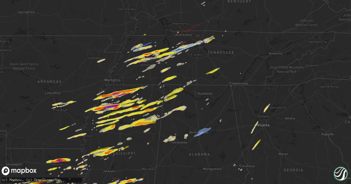
Hail Map on December 9, 2023
Get this storm
December 9 map
$229
one time, instant access
Download today. No call, no setup
Keep the $229
Bought the map and want the full workflow? Apply the entire $229 to a subscription within 7 days. None of it is wasted.
Every map, not just this one
This buys you this map. Subscription and you get every map we run, in the markets you choose from a few cities to whole states to nationwide. Plus real-time alerts the moment a storm fires.
Contact data
Name, contact info, occupancy, even credit band for addresses in the footprint. You go from where it hit to who to call.
Become the source they trust
Unlimited branding weather history reports on demand. You already have the documented answer ready for the property owner, and you are the one who showed up with it.
Property data and RoofTrace estimates
Pull up any address you have got, its value and the exact code rules for that jurisdiction, straight from One Click Code. Then RoofTrace estimates the squares, pitch, and roof value, priced the way you price.
States Impacted by Hail Map on December 9, 2023
Storm reports
Louisiana
| Date | Description |
|---|---|
| 12/09/20235:55 PM CST | Tree downed in the kelly community. |
| 12/09/20235:49 PM CST | Local law enforcement reported golf-ball size hail near richmond. |
| 12/09/20235:28 PM CST | A picture of quarter size hail was posted to social media that fell along highway 557 just south of ed rutledge road. |
| 12/09/20235:25 PM CST | Corrects previous hail report from 3 ne swartz. A picture was posted to social media of ping pong ball size hail that fell in the wham brake community near highway 139 |
| 12/09/20235:20 PM CST | Trees downed along highway 84 just west of winnfield. |
| 12/09/20235:20 PM CST | Quarter size hail reported near the luna community. |
| 12/09/20235:16 PM CST | Report from mping: quarter |
| 12/09/20235:14 PM CST | Hen egg to tennis ball size hail in frenchmans bend subdivision south of sterlington. |
| 12/09/20235:14 PM CST | Golf ball size hail reported on barnes road near schwartz. |
| 12/09/20235:12 PM CST | Hen egg to tennis ball size hail reported in the thatcher point subdivision south of sterlington. |
| 12/09/20235:12 PM CST | Hen egg size hail reported at black bayou national wildlife refuge north of monroe. |
| 12/09/20235:10 PM CST | Hen egg size hail reported in sterlington. |
| 12/09/20235:10 PM CST | Ping pong ball size hail reported on horseshoe lake road. |
| 12/09/20235:03 PM CST | Quarter size hail reported along highway 143 near union parish and ouachita parish line. |
| 12/09/20234:48 PM CST | A picture was posted to social media of ping pong ball size hail that fell along black lake east of campti. |
| 12/09/20234:45 PM CST | A picture of quarter to half dollar size hail was posted to social media that fell along lenard road near the union/ouachita parish line several miles southeast of down |
| 12/09/20234:37 PM CST | A picture was posted to social media of golfball size hail that fell in campti. |
| 12/09/20234:34 PM CST | Report from mping: ping pong ball |
| 12/09/20234:18 PM CST | Ping pong ball size hail reported along interstate 49 at the powhaten exit. |
| 12/09/20234:08 PM CST | Half dollar to ping pong ball size hail reported near marthaville. |
| 12/08/202310:50 PM CST | Roof damage to two homes on frenchtown rd. In central... La. Small portion of a metal roof was peeled back on one home. |
| 12/08/20237:05 PM CST | Corrects previous hail report from richmond. Local law enforcement reported golf-ball size hail near richmond. |
| 12/08/20236:07 PM CST | Local law enforcement reported a fallen tree on smalling rd near rayville in richland parish. |
| 12/08/20236:00 PM CST | Trees downed along highway 165 between tullos and urania. |
Florida
| Date | Description |
|---|---|
| 12/09/20235:49 AM CST | Trees down at yates settlement and douglas ferry rd. |
| 12/09/20235:32 AM CST | Radar confirmed tornado multiple reports of trees down in gritney and a structure on fire. |
Alabama
| Date | Description |
|---|---|
| 12/09/20235:39 PM CST | Colbert county 911 reported a tree down at the intersection of highway 72 and natchez trace access road. Tree is not blocking the roadway. Time estimated by radar. |
| 12/09/20234:42 AM CST | Reports of possible structures damaged along lee road 11. |
| 12/09/20234:42 AM CST | Resident reports no damage to home but outdoor patio items were blown 20 to 100 feet away from their original location... Knocked over some motorcycles wrapped shade sa |
| 12/09/20234:38 AM CST | Corrects previous tstm wnd dmg reports from 3 nw marvyn. Trees down along lee county road 39 between lee road 11 and alabama highway 51. Possible tornado. |
| 12/09/20234:38 AM CST | Trees down along lee county road 39 between lee road 11 and u.s. Highway 51. Possible tonrado. |
| 12/09/20234:38 AM CST | Corrects previous tstm wnd dmg report from 3 nw marvyn. Trees down along lee county road 39 between lee road 11 and u.s. Highway 51. Possible tornado. |
| 12/09/20234:37 AM CST | Tree reported down along lee road 11. Possible tornado. |
| 12/09/20234:36 AM CST | Trees down blocking lee road 29. |
| 12/09/20234:35 AM CST | Reports of trees down near lee road 11 and u.s. Highway 80. |
| 12/09/20234:25 AM CST | Crenshaw county ema relayed a report of hail up to 1 inch in diameter falling in the southern most portions of the county. Time estimated from radar. |
| 12/09/20231:48 AM CST | Front roof peeled off of the front along with minor siding damage to the cherokee county farmers coop building along cherokee cr 25. Time estimated by radar. |
| 12/09/20231:48 AM CST | Corrects previous tstm wnd dmg report from 1 w centre. Front roof peeled off along with minor front siding damage to the cherokee county farmers coop building along che |
| 12/09/20231:47 AM CST | Tds off eox radar. |
| 12/09/20231:33 AM CST | Henry county emergency management reports several trees down on cr 117... Cr 210... Cr 29... Along with damage to a shed on cr 29. Radar confirmed tornadic debris signa |
| 12/09/20231:20 AM CST | Tds off eox radar. |
| 12/09/202312:50 AM CST | Trees down across the road blocking traffic from both directions. Time estimated by radar. |
| 12/09/202312:23 AM CST | Corrects previous tstm wnd gst report from birmingham international airport for max wind gust speed. |
| 12/09/202312:12 AM CST | Reports of trees down on house at the following locations in mountain brook: locksley drive... Knollwood drive... Eaton road... Cherokee drive... Spring rock road... St |
| 12/09/202312:11 AM CST | Structural damage to a tire service station along green springs highway north of lakeshore parkway via photo. Also snapped trees and additional roof damage visible to a |
| 12/09/202312:11 AM CST | Some roof damage to apartments just east of interstate 65 and north of lakeshore parkway evident in viewer photos submitted to broadcast meteorologist. Time estimated b |
| 12/09/202312:10 AM CST | Reports of trees down on houses at the following locations in vestavia hills: farringtonwoods drive... Valley park drive... Fleetwood drive and holly oak drive. Time es |
| 12/09/202312:10 AM CST | Numerous trees down on wellington road. |
| 12/09/202312:09 AM CST | Damage to a part of the roof of a brick home likely due to a large fallen tree. Time estimated by radar. Report by broadcast meteorologist thorough social media. |
| 12/09/202312:08 AM CST | Corrects previous tstm wnd dmg report from 1 sw homewood. Photos of a vehicle flipped in a hotel parking lot shared via broadcast media on social media. |
| 12/09/202312:08 AM CST | Tree down on a residence. |
| 12/09/202312:07 AM CST | Trees down at several locations in the vestavia hills... Bluff park area. |
| 12/09/202312:07 AM CST | Tree down onto a house. Possible entrapment. |
| 12/09/202312:06 AM CST | Shady brook circle impassible due to downed trees. |
| 12/08/202310:12 PM CST | Tree down on cr 67 in langston. Time estimated from radar. |
| 12/08/20239:30 PM CST | Tree down at cr 109 and cr 30 in scottsboro. Time estimated from radar. |
| 12/08/20239:25 PM CST | Power line down in front of merchants bank in fairview. Time estimated from radar. |
| 12/08/20238:50 PM CST | Adds detail to previous tstm wnd dmg report from 8 wsw owens crossroads. Tree down with reported road blockage on river loop rd... Just east of 231 in laceys spring. Ti |
| 12/08/20238:50 PM CST | Tree down with reported road blockage in laceys spring. Time estimated from radar. |
| 12/08/20237:18 PM CST | Emergency manager reported quarter-size hail at county road 92 in elgin. |
| 12/08/20236:42 PM CST | A tree was knocked down and partially blocking the roadway at the intersection of keller quarry road and bluff ct. Time estimated by radar. |
Mississippi
| Date | Description |
|---|---|
| 12/09/20235:50 PM CST | Near highway 341 and cossey rd. |
| 12/09/20235:45 PM CST | Ping-pong ball size hail reported in holcomb. |
| 12/09/20235:42 PM CST | A tree was blown down along county road 9 south of bay springs. |
| 12/09/20235:40 PM CST | Emergency management reported a tree down near bay springs. |
| 12/09/20235:30 PM CST | A local report indicates 1.00 inch wind near Ecru |
| 12/09/20235:17 PM CST | Hail up to the size of ping pong balls. Report via mping. |
| 12/09/20235:12 PM CST | Hail was at least half-dollar sized. |
| 12/09/20235:08 PM CST | Half dollar size hail fell east of new albany on highway 30. |
| 12/09/20234:42 PM CST | A local report indicates 1.00 inch wind near Water Valley |
| 12/09/20234:20 PM CST | Highway 6 and cr 409. |
| 12/09/20234:19 PM CST | Quarter size hail reported in ruleville. |
| 12/09/20234:16 PM CST | Quarter size hail reported in dockery... On hwy 8... East of cleveland. |
| 12/09/20234:11 PM CST | A local report indicates 1.00 inch wind near Walnut |
| 12/09/20233:55 PM CST | A local report indicates 1.00 inch wind near Ashland |
| 12/09/20233:40 PM CST | A local report indicates 2.75 inch wind near 1 ENE Batesville |
| 12/09/20233:39 PM CST | Power flashes observed. |
| 12/09/20233:20 PM CST | Hail up to the size of ping pong balls. |
| 12/09/20233:10 PM CST | A local report indicates 1.50 inch wind near 4 ESE Red Banks |
| 12/09/20233:05 PM CST | A local report indicates 2.00 inch wind near 1 NW Independence |
| 12/09/20233:00 PM CST | A local report indicates 1.00 inch wind near Red Banks |
| 12/09/20232:48 PM CST | A local report indicates 1.75 inch wind near Lyon |
| 12/09/20232:48 PM CST | Quarter-sized hail at moores plantation on highway 309. |
| 12/09/20232:45 PM CST | A local report indicates 1.00 inch wind near Clarksdale |
| 12/09/20232:30 PM CST | Tennis ball-sized hail in coldwater. |
| 12/09/20232:23 PM CST | Quarter-sized hail in the love community. |
| 12/09/20232:20 PM CST | Golf ball-sized hail at highway 51 and thunderbird dr. |
| 12/09/20231:50 PM CST | Quarter to ping-pong ball-sized hail on academy dr. |
| 12/08/202310:41 PM CST | Emergency management reported several trees and power lines down on main street in enterprise. |
| 12/08/202310:31 PM CST | Large tree down on central road 24 near hwy 573 in rosehill area. |
| 12/08/202310:17 PM CST | Emergency management reported a tree blocking both lanes in the 4300 block of hwy 503 in jasper county due to possible tornado. |
| 12/08/202310:17 PM CST | Corrects previous report from 1 e garlandville. Emergency management reported a tree blocking both lanes in the 4300 block of hwy 503 in jasper county. |
| 12/08/202310:13 PM CST | Corrects location of previous tstm wnd dmg report from 3 nw montrose. A tree was blown down onto and blocked both lanes of ms highway 15 just south of the newton county |
| 12/08/202310:13 PM CST | Tree down on hwy 15. |
| 12/08/20239:50 PM CST | Corrects previous report from 3 s raleigh. Social media post show a snapped tree near a home due to strong storms earlier this evening. |
| 12/08/20239:50 PM CST | Social media post show a snapped tree due to a possible tornado. |
| 12/08/20239:45 PM CST | A brief tornado touched down near highway 540 in western smith county. A couple of trees were downed along the highway as the tornado moved east... Dissipating prior to |
| 12/08/20239:31 PM CST | Numerous trees down along hwy 13 due to possible tornado. |
| 12/08/20239:29 PM CST | Emergency management reported several trees down in rankin county across st. John due to possible tornado. |
| 12/08/20239:18 PM CST | A weak tornado produced intermittent damage to trees and vegetation along a path extending from just north of braxton to south of puckett. The tornado tracked along the |
| 12/08/20239:17 PM CST | Multipe trees down across hwy 49 due to possible tornado. |
| 12/08/20237:33 PM CST | Quarter size hail fell in aberdeen. |
| 12/08/20237:25 PM CST | Trees down in the lackey community on old columbus rd. |
| 12/08/20237:23 PM CST | Hail the size of quarters to ping pong balls fell in the fordyke area. |
| 12/08/20237:10 PM CST | Corrects previous hail report from benton. Social media posts from the public reported quarter size hail in benton mississippi... 3 miles south of yazoo city. |
| 12/08/20237:05 PM CST | A photo of the hail was shared by the broadcast media. |
| 12/08/20237:02 PM CST | Quarter size hail reported in yazoo... South of yazoo city. |
| 12/08/20236:45 PM CST | A local report indicates 1.00 inch wind near 5 S Mantachie |
| 12/08/20236:40 PM CST | On highway 15 between houston and woodland. |
| 12/08/20236:20 PM CST | Quarter-sized hail in the palmetto area. |
| 12/08/20236:20 PM CST | Lee acres neighborhood of tupelo. |
| 12/08/20236:18 PM CST | Utility pole snapped at natchez trace parkway and cliff gookin blvd. |
| 12/08/20236:10 PM CST | Social media posts from the public reported quarter size hail in benton mississippi... 3 miles south of yazoo city. |
| 12/08/20236:00 PM CST | Quarter size hail fell at 911 call center in saltilllo. |
Tennessee
| Date | Description |
|---|---|
| 12/09/20235:50 PM CST | Estimated quarter size hail 1 mile north of tn-25 and us-231. |
| 12/09/20235:18 PM CST | Damage reported in castilian springs. Time estimated by radar. |
| 12/09/20235:15 PM CST | Awos station kxnx gallatin airport. |
| 12/09/20235:09 PM CST | Reports of damage on southern side of gallatin. Time estimated by radar and tornado debris signature. |
| 12/09/20234:51 PM CST | Cars flipped on i65. |
| 12/09/20234:50 PM CST | Damage reported... Tornado debris signature on radar as well. |
| 12/09/20234:46 PM CST | Tornado damage reported. Time estimated on radar. Debris signature on radar. |
| 12/09/20234:22 PM CST | Tornado ongoing in springfield. |
| 12/09/20234:21 PM CST | Damage to industrial area. |
| 12/09/20234:03 PM CST | Tornado with debris signature began near this area and tracked across cheatham county into western davidson county. |
| 12/09/20233:57 PM CST | Estimated hail size from social media picture. Time estimated on radar. |
| 12/09/20233:32 PM CST | Damage reported in northern part of dickson county. Time and location estimated from tornado debris signature on radar. |
| 12/09/20233:21 PM CST | A local report indicates 1.00 inch wind near 8 S Camden |
| 12/09/20232:25 PM CST | Half-dollar sized hail off of flatwoods rd. |
| 12/09/20232:20 PM CST | A local report indicates 1.00 inch wind near Camden |
| 12/09/20232:06 PM CST | A local report indicates 1.00 inch wind near Hollow Rock |
| 12/09/20232:00 PM CST | Tornado crossed into kentucky around this location. |
| 12/09/20231:55 PM CST | A local report indicates 1.50 inch wind near Huntingdon |
| 12/09/20231:52 PM CST | Half-dollar size hail in the three way area. |
| 12/09/20231:51 PM CST | Tornado continues across northern portions of clarksville... Tn. |
| 12/09/20231:45 PM CST | Quarter to ping-pong ball sized hail along highway 79. |
| 12/09/20231:43 PM CST | Webcam shows tornado and many reports. First observed debris on radar here. |
| 12/09/20231:36 PM CST | A local report indicates 1.00 inch wind near Atwood |
| 12/09/20231:30 PM CST | A local report indicates 1.75 inch wind near Milan |
| 12/09/20231:24 PM CST | Powerlines down and debris in the road on red top road north of indian mound. Debris signature was noted on radar. Time estimated by radar. |
| 12/09/20231:12 PM CST | Corrects previous hail report from 2 se nutbush. |
| 12/09/202312:05 PM CST | Large trees along chicken road. |
| 12/09/202312:04 PM CST | Structural damage to the national guard armory. |
| 12/09/202312:02 PM CST | Trees and powerlines down south of dresden. |
| 12/09/202311:38 AM CST | Significant damage to the fire station north of rutherford. |
| 12/08/202311:13 PM CST | Tree down blocking a lane of traffic near mine rd and old rutledge pike. |
| 12/08/202310:45 PM CST | Multiple trees down at the intersection of live oak ln and stone rd. |
| 12/08/202310:40 PM CST | Powerlines down at 1200 block of east elmwood drive. |
| 12/08/20238:12 PM CST | Photo received of quarter-sized hail along riley creek road between normandy lake and tullahoma. Time is radar estimated. |
| 12/08/20238:12 PM CST | A few trees down along normandy road. Time is radar estimated. |
| 12/08/20238:05 PM CST | A tree was knocked down at 642 pierce hollow road. Time estimated by radar. |
| 12/08/20237:59 PM CST | A tree was knocked down into the road at the intersection of winchester highway and norman wiseman road. Time estimated by radar. |
| 12/08/20237:59 PM CST | A tree was knocked down into the road at the intersection of winchester road and cobb hollow road. Time estimated by radar. |
| 12/08/20237:55 PM CST | Power lines were knocked down into the road at 110 five points road. Time estimated by radar. |
| 12/08/20236:43 PM CST | Tree down on car on 1100 block of lexington highway southeast of loretto. |
| 12/08/20236:01 PM CST | Tree down in yard of home reported by tennessee valley weather. Location and time estimated. |
Arkansas
| Date | Description |
|---|---|
| 12/09/20232:24 PM CST | A local report indicates 1.00 inch wind near 3 SSE Lake Monticello |
Georgia
| Date | Description |
|---|---|
| 12/09/202312:46 AM CST | Public report and photo of 1 inch hail near dear lick park and mcak rd. |
| 12/08/202311:39 PM CST | Report from mping: quarter |
| 12/08/202311:30 PM CST | Tree on home near renae ln. |
| 12/08/202311:15 PM CST | Tree down at lee rd and e county line rd. |
| 12/08/202311:15 PM CST | Tree fell across road at skyview dr and aspen dr. One car hit the tree after it fell across the road. |
| 12/08/202311:15 PM CST | Tree down on house near intersection of chapel hill rd and bomar rd. |
| 12/08/202311:10 PM CST | Corrects previous hail report from 1 ne haralson. Report from mping: quarter |
Kentucky
| Date | Description |
|---|---|
| 12/09/20235:48 PM CST | Tree down on a power line. |
| 12/09/20233:13 PM CST | Roof damage to hotel. |
| 12/09/20232:18 PM CST | Dispatch reports several houses and barns damaged... Mainly near olmstead... Kentucky. |
| 12/09/20232:14 PM CST | Social media and public reports quite a bit of damage in and near allensville. |
| 12/09/20232:11 PM CST | Trained spotter reports many trees and powerlines down and barnes destroyed in addition to minor damage to houses along us 79 southwest of allensville. Time estimated f |
| 12/09/20232:03 PM CST | Trees down along us 41 southeast of trenton... Ky. Relayed by whop radio. Time estimated from radar. |
| 12/09/20231:57 PM CST | Continuous 13.2 mile track from west of guthrie at the state line to south of allensville at the logan county line. Worst damage consistent with 125 mph... Ef-2 intensi |
Texas
| Date | Description |
|---|---|
| 12/08/20237:04 PM CST | Photo posted to social media. Mostly dimes... But a few to around quarter size. |
| 12/08/20236:13 PM CST | Public report of quarter hail in kingwood from social media. |
Cities Impacted by Hail Map on December 9, 2023
- Fulton, KY
- Kenton, TN
- Trimble, TN
- Newbern, TN
- Dyersburg, TN
- Dyer, TN
- Rutherford, TN
- Greenfield, TN
- Sharon, TN
- Dresden, TN
- Gleason, TN
- Humphrey, AR
- Stuttgart, AR
- Humboldt, TN
- Trenton, TN
- Milan, TN
- Indian Mound, TN
- Woodlawn, TN
- Lavinia, TN
- Atwood, TN
- Brownsville, TN
- Bells, TN
- Gadsden, TN
- Clarksville, TN
- Trezevant, TN
- Huntingdon, TN
- McKenzie, TN
- Trenton, KY
- Guthrie, KY
- Tunica, MS
- Coldwater, MS
- Sarah, MS
- Camden, TN
- Hollow Rock, TN
- Bruceton, TN
- Buena Vista, TN
- Senatobia, MS
- Warren, AR
- Wilmar, AR
- Monticello, AR
- Mellwood, AR
- Crumrod, AR
- Clarksdale, MS
- Allensville, KY
- Olmstead, KY
- Russellville, KY
- Medina, TN
- Hernando, MS
- Dundee, MS
- Lyon, MS
- Coahoma, MS
- Holladay, TN
- Byhalia, MS
- Holly Springs, MS
- Red Banks, MS
- Marks, MS
- Sledge, MS
- Waverly, TN
- Hurricane Mills, TN
- New Johnsonville, TN
- Cumberland Furnace, TN
- Vanleer, TN
- Cunningham, TN
- Lamar, MS
- Michigan City, MS
- Ashland, MS
- Westport, TN
- Yuma, TN
- McEwen, TN
- Dickson, TN
- Charlotte, TN
- Sardis, MS
- Crenshaw, MS
- Batesville, MS
- Courtland, MS
- Oxford, MS
- Walnut, MS
- Falkner, MS
- Tiplersville, MS
- White Bluff, TN
- Ashland City, TN
- Burns, TN
- Kingston Springs, TN
- Zwolle, LA
- Belmont, LA
- Pleasant Hill, LA
- Broaddus, TX
- Marthaville, LA
- Robeline, LA
- Pegram, TN
- Nashville, TN
- Springfield, TN
- Bronson, TX
- Taylor, MS
- University, MS
- Shelbyville, KY
- Waddy, KY
- Thaxton, MS
- Cleveland, MS
- Doddsville, MS
- Drew, MS
- Ruleville, MS
- Como, MS
- Pineland, TX
- Abbeville, MS
- Tutwiler, MS
- Sumner, MS
- Lambert, MS
- Charleston, MS
- Enid, MS
- Oakland, MS
- Pope, MS
- Water Valley, MS
- Potts Camp, MS
- Etta, MS
- Myrtle, MS
- Madison, TN
- Natchitoches, LA
- Campti, LA
- Goldonna, LA
- Hemphill, TX
- Cascilla, MS
- Scobey, MS
- Tillatoba, MS
- Minter City, MS
- Mendenhall, MS
- Magee, MS
- Hendersonville, TN
- Ruston, LA
- Choudrant, LA
- Downsville, LA
- Calhoun, LA
- Eros, LA
- Chatham, LA
- Gallatin, TN
- New Albany, MS
- Blue Springs, MS
- Winnfield, LA
- Monroe, LA
- West Monroe, LA
- Sterlington, LA
- Guntown, MS
- Baldwyn, MS
- Paris, MS
- Pontotoc, MS
- Coffeeville, MS
- Raleigh, MS
- Mize, MS
- Liberty, MS
- Goodlettsville, TN
- Woodville, TX
- Ecru, MS
- Banner, MS
- Bruce, MS
- Collinston, LA
- Philipp, MS
- Holcomb, MS
- Grenada, MS
- Dodson, LA
- Olla, LA
- Sikes, LA
- Chester, TX
- Colmesneil, TX
- Taylorsville, MS
- Bay Springs, MS
- Old Hickory, TN
- Oak Ridge, LA
- Mer Rouge, LA
- Whites Creek, TN
- Castalian Springs, TN
- Bethpage, TN
- Livingston, TX
- Kingwood, TX
- Porter, TX
- Huffman, TX
- Humble, TX
- Warren, TX
- Savannah, TN
- Olivehill, TN
- Lutts, TN
- Waynesboro, TN
- Collinwood, TN
- Belden, MS
- Louin, MS
- Tupelo, MS
- Saltillo, MS
- Houlka, MS
- Randolph, MS
- Hillister, TX
- Jasper, TX
- Duck Hill, MS
- Gore Springs, MS
- McCarley, MS
- Lena, LA
- Rolling Fork, MS
- Yazoo City, MS
- Louise, MS
- Mount Juliet, TN
- Lebanon, TN
- Tchula, MS
- Lexington, MS
- Boyce, LA
- Fred, TX
- Dayton, TX
- Shannon, MS
- Eupora, MS
- Calhoun City, MS
- Liberty, TX
- Devers, TX
- Spurger, TX
- Newton, TX
- Kirbyville, TX
- Pineville, LA
- Marietta, MS
- Dennis, MS
- New Site, MS
- Mantachie, MS
- Belmont, MS
- Golden, MS
- Fulton, MS
- Schlater, MS
- Greenwood, MS
- Carrollton, MS
- Alexandria, LA
- Verona, MS
- Mooreville, MS
- Plantersville, MS
- Vardaman, MS
- Mantee, MS
- Houston, MS
- Woodland, MS
- Cedarbluff, MS
- West Point, MS
- Okolona, MS
- Prairie, MS
- Aberdeen, MS
- Vaughan, MS
- Benton, MS
- Pickens, MS
- Amory, MS
- Cherokee, AL
- Tuscumbia, AL
- Florence, AL
- Sheffield, AL
- Muscle Shoals, AL
- Killen, AL
- Lexington, AL
- Rogersville, AL
- Red Bay, AL
- Russellville, AL
- Hamilton, MS
- Durant, MS
- Goodman, MS
- Sallis, MS
- Kosciusko, MS
- Ethel, MS
- Braxton, MS
- Greenville, GA
- Gay, GA
- Senoia, GA
- Brooks, GA
- Birmingham, AL
- Brewton, AL
- Castleberry, AL
- Evergreen, AL
- Andalusia, AL
- Red Level, AL
- Marianna, AR
- West Helena, AR
- Opelika, AL
- Salem, AL
- Fayetteville, TN
- Petersburg, TN
- Shelbyville, TN
- Wartrace, TN
- Tullahoma, TN
- Normandy, TN
- Manchester, TN
- Beaumont, TX
- China, TX
- Clopton, AL
- Abbeville, AL
- Newville, AL
- Headland, AL
- Columbia, AL
- Bonifay, FL
- Auburn, KY
- Woodburn, KY
- Bowling Green, KY
- Lexington, TN
- Iuka, MS
- Wisner, LA
- Sicily Island, LA
- Mayersville, MS
- Caneyville, KY
- Horse Branch, KY
- Hampshire, TN
- Hohenwald, TN
- Centerville, TN
- Duck River, TN
- Dermott, AR
- McGehee, AR
- Arkansas City, AR
- Rohwer, AR
- Hickory Valley, TN
- Ragley, LA
- Pelican, LA
- Saline, LA
- Coushatta, LA
- Henry, TN
- Paris, TN
- Pickens, AR
- Tillar, AR
- Winchester, AR
- Bentonia, MS
- Erin, TN
- Nettleton, MS
- Merigold, MS
- Mound Bayou, MS
- Trenton, GA
- Arab, AL
- Union Grove, AL
- Sondheimer, LA
- Fairview, TN
- Lafayette, TN
- Newellton, LA
- Beech Bluff, TN
- Grayson, LA
- Columbia, LA
- Kelly, LA
- Northport, AL
- Berry, AL
- Tallulah, LA
- Pulaski, TN
- Magnolia, MS
- Clio, AL
- Clayton, AL
- Skipperville, AL
- Ariton, AL
- Hickory Flat, MS
- Harrisonburg, LA
- Gamaliel, KY
- Lumpkin, GA
- Anacoco, LA
- Florien, LA
- Pattison, MS
- Seale, AL
- Hatchechubbee, AL
- Williamstown, KY
- Corinth, KY
- Falmouth, KY
- Burkeville, TX
- Gadsden, AL
- Ohatchee, AL
- Farmerville, LA
- Bastrop, LA
- Rayville, LA
- Pioneer, LA
- Hazlehurst, MS
- Hermanville, MS
- Pittsboro, MS
- Clayton, LA
- Bath Springs, TN
- Scotts Hill, TN
- Saltillo, TN
- Clifton, TN
- Linden, TN
- Decaturville, TN
- Tullos, LA
- Bay, AR
- Black Oak, AR
- Trumann, AR
- Lake City, AR
- Caraway, AR
- Woodstock, GA
- Dawsonville, GA
- Ball Ground, GA
- Cumming, GA
- Alpharetta, GA
- Canton, GA
- West, MS
- Woodbury, GA
- Vicksburg, MS
- Noble, LA
- Bogue Chitto, MS
- Brookhaven, MS
- Smithdale, MS
- McCall Creek, MS
- Dequincy, LA
- Longville, LA
- Singer, LA
- Mansfield, LA
- Converse, LA
- Palmetto, GA
- Huron, TN
- Bradford, TN
- Carthage, MS
- Goodrich, TX
- Shepherd, TX
- Lake Village, AR
- Zavalla, TX
- Redfield, AR
- Jefferson, AR
- Sheridan, AR
- Halls, TN
- Gates, TN
- Ripley, TN
- Delhi, LA
- Mangham, LA
- Baskin, LA
- Itta Bena, MS
- Sunflower, MS
- Houston, TX
- Spring, TX
- Whitesburg, GA
- Smyrna, GA
- Douglasville, GA
- Lithia Springs, GA
- Mableton, GA
- Austell, GA
- Fairburn, GA
- Marietta, GA
- Newnan, GA
- Detroit, AL
- Sulligent, AL
- Soddy Daisy, TN
- Pinson, TN
- Jackson, TN
- Medon, TN
- Luray, TN
- Henderson, TN
- Wabbaseka, AR
- Cullman, AL
- Baileyton, AL
- Leesville, LA
- Gilbert, LA
- Atlanta, LA
- Sherrill, AR
- Altheimer, AR
- Almyra, AR
- Tucker, AR
- England, AR
- White Hall, AR
- Waterloo, AL
- Jonesville, LA
- Smithville, MS
- Hamburg, AR
- Greenville, MS
- Montrose, AR
- Blue Mountain, MS
- Summit, MS
- Sweeny, TX
- Tishomingo, MS
- Georgetown, MS
- Starkville, MS
- Jena, LA
- Rosepine, LA
- Deridder, LA
- Buna, TX
- Deweyville, TX
- Call, TX
- Carrollton, AL
- Starks, LA
- Haleyville, AL
- Lake Providence, LA
- Cary, MS
- Holly Bluff, MS
- Colfax, LA
- Double Springs, AL
- Bear Creek, AL
- Moulton, AL
- Hamilton, AL
- Houston, AL
- Guin, AL
- Hackleburg, AL
- Santa Rosa Beach, FL
- Miramar Beach, FL
- Boyle, MS
- Shaw, MS
- Pitkin, LA
- Beaverton, AL
- Macon, MS
- Brooksville, MS
- Paulding, MS
- Pinola, MS
- Dozier, AL
- Brantley, AL
- Galveston, TX
- Freeport, TX
- Centreville, MS
- Weir, MS
- Kilmichael, MS
- McCool, MS
- French Camp, MS
- Pachuta, MS
- Vossburg, MS
- Rose Hill, MS
- Tremont, MS
- El Campo, TX
- Lexa, AR
- Helena, AR
- Saint Joseph, LA
- Elaine, AR
- Vance, MS
- Alligator, MS
- Crosby, TX
- Bolivar, TN
- Wiergate, TX
- Hartsville, TN
- Williamsport, TN
- Gordo, AL
- Monterey, LA
- Harrisville, MS
- Nome, TX
- Elba, AL
- Winona, MS
- Eva, TN
- Owens Cross Roads, AL
- Huntsville, AL
- New Hope, AL
- Cedar Grove, TN
- Wesson, MS
- Lobelville, TN
- Sugar Tree, TN
- Dauphin Island, AL
- Brent, AL
- Echola, AL
- Elrod, AL
- Buhl, AL
- Coker, AL
- Friendship, TN
- Alamo, TN
- Brookwood, AL
- Adger, AL
- West Columbia, TX
- Lorman, MS
- Port Gibson, MS
- Transylvania, LA
- Mora, LA
- Destin, FL
- Waterproof, LA
- Leoma, TN
- Prospect, TN
- Anderson, AL
- Five Points, TN
- Goodspring, TN
- Minor Hill, TN
- Silsbee, TX
- Vidor, TX
- Indianola, MS
- Parsons, TN
- Joelton, TN
- Counce, TN
- Addison, AL
- Danville, AL
- Greenwood Springs, MS
- Newhebron, MS
- Reform, AL
- Mccomb, MS
- Auburn, AL
- Saratoga, TX
- Only, TN
- Covington, TN
- Henning, TN
- Oakfield, TN
- Wildersville, TN
- Darden, TN
- Kountze, TX
- Bellefontaine, MS
- Opp, AL
- Bessemer, AL
- Leeds, AL
- Pell City, AL
- Odenville, AL
- Trussville, AL
- Moody, AL