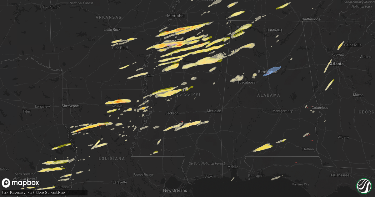
Hail Map in Mississippi on December 9, 2023
Get this storm
December 9 map
$229
one time, instant access
Download today. No call, no setup
Keep the $229
Bought the map and want the full workflow? Apply the entire $229 to a subscription within 7 days. None of it is wasted.
Every map, not just this one
This buys you this map. Subscription and you get every map we run, in the markets you choose from a few cities to whole states to nationwide. Plus real-time alerts the moment a storm fires.
Contact data
Name, contact info, occupancy, even credit band for addresses in the footprint. You go from where it hit to who to call.
Become the source they trust
Unlimited branding weather history reports on demand. You already have the documented answer ready for the property owner, and you are the one who showed up with it.
Property data and RoofTrace estimates
Pull up any address you have got, its value and the exact code rules for that jurisdiction, straight from One Click Code. Then RoofTrace estimates the squares, pitch, and roof value, priced the way you price.
Storm reports in Mississippi
Mississippi
| Date | Description |
|---|---|
| 12/09/20235:50 PM CST | Near highway 341 and cossey rd. |
| 12/09/20235:45 PM CST | Ping-pong ball size hail reported in holcomb. |
| 12/09/20235:42 PM CST | A tree was blown down along county road 9 south of bay springs. |
| 12/09/20235:40 PM CST | Emergency management reported a tree down near bay springs. |
| 12/09/20235:30 PM CST | A local report indicates 1.00 inch wind near Ecru |
| 12/09/20235:17 PM CST | Hail up to the size of ping pong balls. Report via mping. |
| 12/09/20235:12 PM CST | Hail was at least half-dollar sized. |
| 12/09/20235:08 PM CST | Half dollar size hail fell east of new albany on highway 30. |
| 12/09/20234:42 PM CST | A local report indicates 1.00 inch wind near Water Valley |
| 12/09/20234:20 PM CST | Highway 6 and cr 409. |
| 12/09/20234:19 PM CST | Quarter size hail reported in ruleville. |
| 12/09/20234:16 PM CST | Quarter size hail reported in dockery... On hwy 8... East of cleveland. |
| 12/09/20234:11 PM CST | A local report indicates 1.00 inch wind near Walnut |
| 12/09/20233:55 PM CST | A local report indicates 1.00 inch wind near Ashland |
| 12/09/20233:40 PM CST | A local report indicates 2.75 inch wind near 1 ENE Batesville |
| 12/09/20233:39 PM CST | Power flashes observed. |
| 12/09/20233:20 PM CST | Hail up to the size of ping pong balls. |
| 12/09/20233:10 PM CST | A local report indicates 1.50 inch wind near 4 ESE Red Banks |
| 12/09/20233:05 PM CST | A local report indicates 2.00 inch wind near 1 NW Independence |
| 12/09/20233:00 PM CST | A local report indicates 1.00 inch wind near Red Banks |
| 12/09/20232:48 PM CST | A local report indicates 1.75 inch wind near Lyon |
| 12/09/20232:48 PM CST | Quarter-sized hail at moores plantation on highway 309. |
| 12/09/20232:45 PM CST | A local report indicates 1.00 inch wind near Clarksdale |
| 12/09/20232:30 PM CST | Tennis ball-sized hail in coldwater. |
| 12/09/20232:23 PM CST | Quarter-sized hail in the love community. |
| 12/09/20232:20 PM CST | Golf ball-sized hail at highway 51 and thunderbird dr. |
| 12/09/20231:50 PM CST | Quarter to ping-pong ball-sized hail on academy dr. |
| 12/08/202310:41 PM CST | Emergency management reported several trees and power lines down on main street in enterprise. |
| 12/08/202310:31 PM CST | Large tree down on central road 24 near hwy 573 in rosehill area. |
| 12/08/202310:17 PM CST | Corrects previous report from 1 e garlandville. Emergency management reported a tree blocking both lanes in the 4300 block of hwy 503 in jasper county. |
| 12/08/202310:17 PM CST | Emergency management reported a tree blocking both lanes in the 4300 block of hwy 503 in jasper county due to possible tornado. |
| 12/08/202310:13 PM CST | Corrects location of previous tstm wnd dmg report from 3 nw montrose. A tree was blown down onto and blocked both lanes of ms highway 15 just south of the newton county |
| 12/08/202310:13 PM CST | Tree down on hwy 15. |
| 12/08/20239:50 PM CST | Social media post show a snapped tree due to a possible tornado. |
| 12/08/20239:50 PM CST | Corrects previous report from 3 s raleigh. Social media post show a snapped tree near a home due to strong storms earlier this evening. |
| 12/08/20239:45 PM CST | A brief tornado touched down near highway 540 in western smith county. A couple of trees were downed along the highway as the tornado moved east... Dissipating prior to |
| 12/08/20239:31 PM CST | Numerous trees down along hwy 13 due to possible tornado. |
| 12/08/20239:29 PM CST | Emergency management reported several trees down in rankin county across st. John due to possible tornado. |
| 12/08/20239:18 PM CST | A weak tornado produced intermittent damage to trees and vegetation along a path extending from just north of braxton to south of puckett. The tornado tracked along the |
| 12/08/20239:17 PM CST | Multipe trees down across hwy 49 due to possible tornado. |
| 12/08/20237:33 PM CST | Quarter size hail fell in aberdeen. |
| 12/08/20237:25 PM CST | Trees down in the lackey community on old columbus rd. |
| 12/08/20237:23 PM CST | Hail the size of quarters to ping pong balls fell in the fordyke area. |
| 12/08/20237:10 PM CST | Corrects previous hail report from benton. Social media posts from the public reported quarter size hail in benton mississippi... 3 miles south of yazoo city. |
| 12/08/20237:05 PM CST | A photo of the hail was shared by the broadcast media. |
| 12/08/20237:02 PM CST | Quarter size hail reported in yazoo... South of yazoo city. |
| 12/08/20236:45 PM CST | A local report indicates 1.00 inch wind near 5 S Mantachie |
| 12/08/20236:40 PM CST | On highway 15 between houston and woodland. |
| 12/08/20236:20 PM CST | Lee acres neighborhood of tupelo. |
| 12/08/20236:20 PM CST | Quarter-sized hail in the palmetto area. |
| 12/08/20236:18 PM CST | Utility pole snapped at natchez trace parkway and cliff gookin blvd. |
| 12/08/20236:10 PM CST | Social media posts from the public reported quarter size hail in benton mississippi... 3 miles south of yazoo city. |
| 12/08/20236:00 PM CST | Quarter size hail fell at 911 call center in saltilllo. |
All States Impacted by Hail Map on December 9, 2023
Cities Impacted by Hail Map on December 9, 2023
- Fulton, KY
- Kenton, TN
- Trimble, TN
- Newbern, TN
- Dyersburg, TN
- Dyer, TN
- Rutherford, TN
- Greenfield, TN
- Sharon, TN
- Dresden, TN
- Gleason, TN
- Humphrey, AR
- Stuttgart, AR
- Humboldt, TN
- Trenton, TN
- Milan, TN
- Indian Mound, TN
- Woodlawn, TN
- Lavinia, TN
- Atwood, TN
- Brownsville, TN
- Bells, TN
- Gadsden, TN
- Clarksville, TN
- Trezevant, TN
- Huntingdon, TN
- McKenzie, TN
- Trenton, KY
- Guthrie, KY
- Tunica, MS
- Coldwater, MS
- Sarah, MS
- Camden, TN
- Hollow Rock, TN
- Bruceton, TN
- Buena Vista, TN
- Senatobia, MS
- Warren, AR
- Wilmar, AR
- Monticello, AR
- Mellwood, AR
- Crumrod, AR
- Clarksdale, MS
- Allensville, KY
- Olmstead, KY
- Russellville, KY
- Medina, TN
- Hernando, MS
- Dundee, MS
- Lyon, MS
- Coahoma, MS
- Holladay, TN
- Byhalia, MS
- Holly Springs, MS
- Red Banks, MS
- Marks, MS
- Sledge, MS
- Waverly, TN
- Hurricane Mills, TN
- New Johnsonville, TN
- Cumberland Furnace, TN
- Vanleer, TN
- Cunningham, TN
- Lamar, MS
- Michigan City, MS
- Ashland, MS
- Westport, TN
- Yuma, TN
- McEwen, TN
- Dickson, TN
- Charlotte, TN
- Sardis, MS
- Crenshaw, MS
- Batesville, MS
- Courtland, MS
- Oxford, MS
- Walnut, MS
- Falkner, MS
- Tiplersville, MS
- White Bluff, TN
- Ashland City, TN
- Burns, TN
- Kingston Springs, TN
- Zwolle, LA
- Belmont, LA
- Pleasant Hill, LA
- Broaddus, TX
- Marthaville, LA
- Robeline, LA
- Pegram, TN
- Nashville, TN
- Springfield, TN
- Bronson, TX
- Taylor, MS
- University, MS
- Shelbyville, KY
- Waddy, KY
- Thaxton, MS
- Cleveland, MS
- Doddsville, MS
- Drew, MS
- Ruleville, MS
- Como, MS
- Pineland, TX
- Abbeville, MS
- Tutwiler, MS
- Sumner, MS
- Lambert, MS
- Charleston, MS
- Enid, MS
- Oakland, MS
- Pope, MS
- Water Valley, MS
- Potts Camp, MS
- Etta, MS
- Myrtle, MS
- Madison, TN
- Natchitoches, LA
- Campti, LA
- Goldonna, LA
- Hemphill, TX
- Cascilla, MS
- Scobey, MS
- Tillatoba, MS
- Minter City, MS
- Mendenhall, MS
- Magee, MS
- Hendersonville, TN
- Ruston, LA
- Choudrant, LA
- Downsville, LA
- Calhoun, LA
- Eros, LA
- Chatham, LA
- Gallatin, TN
- New Albany, MS
- Blue Springs, MS
- Winnfield, LA
- Monroe, LA
- West Monroe, LA
- Sterlington, LA
- Guntown, MS
- Baldwyn, MS
- Paris, MS
- Pontotoc, MS
- Coffeeville, MS
- Raleigh, MS
- Mize, MS
- Liberty, MS
- Goodlettsville, TN
- Woodville, TX
- Ecru, MS
- Banner, MS
- Bruce, MS
- Collinston, LA
- Philipp, MS
- Holcomb, MS
- Grenada, MS
- Dodson, LA
- Olla, LA
- Sikes, LA
- Chester, TX
- Colmesneil, TX
- Taylorsville, MS
- Bay Springs, MS
- Old Hickory, TN
- Oak Ridge, LA
- Mer Rouge, LA
- Whites Creek, TN
- Castalian Springs, TN
- Bethpage, TN
- Livingston, TX
- Kingwood, TX
- Porter, TX
- Huffman, TX
- Humble, TX
- Warren, TX
- Savannah, TN
- Olivehill, TN
- Lutts, TN
- Waynesboro, TN
- Collinwood, TN
- Belden, MS
- Louin, MS
- Tupelo, MS
- Saltillo, MS
- Houlka, MS
- Randolph, MS
- Hillister, TX
- Jasper, TX
- Duck Hill, MS
- Gore Springs, MS
- McCarley, MS
- Lena, LA
- Rolling Fork, MS
- Yazoo City, MS
- Louise, MS
- Mount Juliet, TN
- Lebanon, TN
- Tchula, MS
- Lexington, MS
- Boyce, LA
- Fred, TX
- Dayton, TX
- Shannon, MS
- Eupora, MS
- Calhoun City, MS
- Liberty, TX
- Devers, TX
- Spurger, TX
- Newton, TX
- Kirbyville, TX
- Pineville, LA
- Marietta, MS
- Dennis, MS
- New Site, MS
- Mantachie, MS
- Belmont, MS
- Golden, MS
- Fulton, MS
- Schlater, MS
- Greenwood, MS
- Carrollton, MS
- Alexandria, LA
- Verona, MS
- Mooreville, MS
- Plantersville, MS
- Vardaman, MS
- Mantee, MS
- Houston, MS
- Woodland, MS
- Cedarbluff, MS
- West Point, MS
- Okolona, MS
- Prairie, MS
- Aberdeen, MS
- Vaughan, MS
- Benton, MS
- Pickens, MS
- Amory, MS
- Cherokee, AL
- Tuscumbia, AL
- Florence, AL
- Sheffield, AL
- Muscle Shoals, AL
- Killen, AL
- Lexington, AL
- Rogersville, AL
- Red Bay, AL
- Russellville, AL
- Hamilton, MS
- Durant, MS
- Goodman, MS
- Sallis, MS
- Kosciusko, MS
- Ethel, MS
- Braxton, MS
- Greenville, GA
- Gay, GA
- Senoia, GA
- Brooks, GA
- Birmingham, AL
- Brewton, AL
- Castleberry, AL
- Evergreen, AL
- Andalusia, AL
- Red Level, AL
- Marianna, AR
- West Helena, AR
- Opelika, AL
- Salem, AL
- Fayetteville, TN
- Petersburg, TN
- Shelbyville, TN
- Wartrace, TN
- Tullahoma, TN
- Normandy, TN
- Manchester, TN
- Beaumont, TX
- China, TX
- Clopton, AL
- Abbeville, AL
- Newville, AL
- Headland, AL
- Columbia, AL
- Bonifay, FL
- Auburn, KY
- Woodburn, KY
- Bowling Green, KY
- Lexington, TN
- Iuka, MS
- Wisner, LA
- Sicily Island, LA
- Mayersville, MS
- Caneyville, KY
- Horse Branch, KY
- Hampshire, TN
- Hohenwald, TN
- Centerville, TN
- Duck River, TN
- Dermott, AR
- McGehee, AR
- Arkansas City, AR
- Rohwer, AR
- Hickory Valley, TN
- Ragley, LA
- Pelican, LA
- Saline, LA
- Coushatta, LA
- Henry, TN
- Paris, TN
- Pickens, AR
- Tillar, AR
- Winchester, AR
- Bentonia, MS
- Erin, TN
- Nettleton, MS
- Merigold, MS
- Mound Bayou, MS
- Trenton, GA
- Arab, AL
- Union Grove, AL
- Sondheimer, LA
- Fairview, TN
- Lafayette, TN
- Newellton, LA
- Beech Bluff, TN
- Grayson, LA
- Columbia, LA
- Kelly, LA
- Northport, AL
- Berry, AL
- Tallulah, LA
- Pulaski, TN
- Magnolia, MS
- Clio, AL
- Clayton, AL
- Skipperville, AL
- Ariton, AL
- Hickory Flat, MS
- Harrisonburg, LA
- Gamaliel, KY
- Lumpkin, GA
- Anacoco, LA
- Florien, LA
- Pattison, MS
- Seale, AL
- Hatchechubbee, AL
- Williamstown, KY
- Corinth, KY
- Falmouth, KY
- Burkeville, TX
- Gadsden, AL
- Ohatchee, AL
- Farmerville, LA
- Bastrop, LA
- Rayville, LA
- Pioneer, LA
- Hazlehurst, MS
- Hermanville, MS
- Pittsboro, MS
- Clayton, LA
- Bath Springs, TN
- Scotts Hill, TN
- Saltillo, TN
- Clifton, TN
- Linden, TN
- Decaturville, TN
- Tullos, LA
- Bay, AR
- Black Oak, AR
- Trumann, AR
- Lake City, AR
- Caraway, AR
- Woodstock, GA
- Dawsonville, GA
- Ball Ground, GA
- Cumming, GA
- Alpharetta, GA
- Canton, GA
- West, MS
- Woodbury, GA
- Vicksburg, MS
- Noble, LA
- Bogue Chitto, MS
- Brookhaven, MS
- Smithdale, MS
- McCall Creek, MS
- Dequincy, LA
- Longville, LA
- Singer, LA
- Mansfield, LA
- Converse, LA
- Palmetto, GA
- Huron, TN
- Bradford, TN
- Carthage, MS
- Goodrich, TX
- Shepherd, TX
- Lake Village, AR
- Zavalla, TX
- Redfield, AR
- Jefferson, AR
- Sheridan, AR
- Halls, TN
- Gates, TN
- Ripley, TN
- Delhi, LA
- Mangham, LA
- Baskin, LA
- Itta Bena, MS
- Sunflower, MS
- Houston, TX
- Spring, TX
- Whitesburg, GA
- Smyrna, GA
- Douglasville, GA
- Lithia Springs, GA
- Mableton, GA
- Austell, GA
- Fairburn, GA
- Marietta, GA
- Newnan, GA
- Detroit, AL
- Sulligent, AL
- Soddy Daisy, TN
- Pinson, TN
- Jackson, TN
- Medon, TN
- Luray, TN
- Henderson, TN
- Wabbaseka, AR
- Cullman, AL
- Baileyton, AL
- Leesville, LA
- Gilbert, LA
- Atlanta, LA
- Sherrill, AR
- Altheimer, AR
- Almyra, AR
- Tucker, AR
- England, AR
- White Hall, AR
- Waterloo, AL
- Jonesville, LA
- Smithville, MS
- Hamburg, AR
- Greenville, MS
- Montrose, AR
- Blue Mountain, MS
- Summit, MS
- Sweeny, TX
- Tishomingo, MS
- Georgetown, MS
- Starkville, MS
- Jena, LA
- Rosepine, LA
- Deridder, LA
- Buna, TX
- Deweyville, TX
- Call, TX
- Carrollton, AL
- Starks, LA
- Haleyville, AL
- Lake Providence, LA
- Cary, MS
- Holly Bluff, MS
- Colfax, LA
- Double Springs, AL
- Bear Creek, AL
- Moulton, AL
- Hamilton, AL
- Houston, AL
- Guin, AL
- Hackleburg, AL
- Santa Rosa Beach, FL
- Miramar Beach, FL
- Boyle, MS
- Shaw, MS
- Pitkin, LA
- Beaverton, AL
- Macon, MS
- Brooksville, MS
- Paulding, MS
- Pinola, MS
- Dozier, AL
- Brantley, AL
- Galveston, TX
- Freeport, TX
- Centreville, MS
- Weir, MS
- Kilmichael, MS
- McCool, MS
- French Camp, MS
- Pachuta, MS
- Vossburg, MS
- Rose Hill, MS
- Tremont, MS
- El Campo, TX
- Lexa, AR
- Helena, AR
- Saint Joseph, LA
- Elaine, AR
- Vance, MS
- Alligator, MS
- Crosby, TX
- Bolivar, TN
- Wiergate, TX
- Hartsville, TN
- Williamsport, TN
- Gordo, AL
- Monterey, LA
- Harrisville, MS
- Nome, TX
- Elba, AL
- Winona, MS
- Eva, TN
- Owens Cross Roads, AL
- Huntsville, AL
- New Hope, AL
- Cedar Grove, TN
- Wesson, MS
- Lobelville, TN
- Sugar Tree, TN
- Dauphin Island, AL
- Brent, AL
- Echola, AL
- Elrod, AL
- Buhl, AL
- Coker, AL
- Friendship, TN
- Alamo, TN
- Brookwood, AL
- Adger, AL
- West Columbia, TX
- Lorman, MS
- Port Gibson, MS
- Transylvania, LA
- Mora, LA
- Destin, FL
- Waterproof, LA
- Leoma, TN
- Prospect, TN
- Anderson, AL
- Five Points, TN
- Goodspring, TN
- Minor Hill, TN
- Silsbee, TX
- Vidor, TX
- Indianola, MS
- Parsons, TN
- Joelton, TN
- Counce, TN
- Addison, AL
- Danville, AL
- Greenwood Springs, MS
- Newhebron, MS
- Reform, AL
- Mccomb, MS
- Auburn, AL
- Saratoga, TX
- Only, TN
- Covington, TN
- Henning, TN
- Oakfield, TN
- Wildersville, TN
- Darden, TN
- Kountze, TX
- Bellefontaine, MS
- Opp, AL
- Bessemer, AL
- Leeds, AL
- Pell City, AL
- Odenville, AL
- Trussville, AL
- Moody, AL


