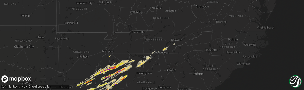
Hail Map in Tennessee on November 29, 2016
The weather event in Tennessee on November 29, 2016 includes Hail map. 6 states and 355 cities were impacted and suffered possible damage. The total estimated number of properties impacted is 0.
Want more than just the map?
Turn this storm into a full workflow.
- Owner + property data so you know who to knock
- OnDemand branded weather history reports to win the "did we even have hail?" argument
- RoofTrace estimate so reps stop guessing numbers at the door
Bought this map? Upgrade within 7 days and we'll credit the $230. (10-15 min setup call)
Hail
0
Estimated number of impacted properties by a 1.00" hail or larger0
Estimated number of impacted properties by a 1.75" hail or larger0
Estimated number of impacted properties by a 2.50" hail or largerStorm reports in Tennessee
Tennessee
| Date | Description |
|---|---|
| 11/29/20165:30 AM CST | Few trees down on the west side of chattanooga. |
| 11/29/20165:25 AM CST | Few trees down. |
| 11/29/20165:20 AM CST | Trees down across the county. |
| 11/29/20164:45 AM CST | Numerous trees down countywide. |
| 11/29/20164:35 AM CST | 1 roof removed completely from home. Roof damage to another home as well as a barn. |
| 11/29/20164:30 AM CST | Several trees down in knoxville. |
| 11/29/20164:25 AM CST | Trees down. |
| 11/29/20164:20 AM CST | Trees down |
| 11/29/20164:15 AM CST | Several trees down and a out building blown over. |
| 11/29/20164:00 AM CST | Trees and power lines down in the athens area. Widespread power outages. |
| 11/29/20163:30 AM CST | Trees down. |
| 11/29/20163:30 AM CST | Trees down in the decatur area. |
| 11/29/20162:50 AM CST | Trees and power lines down. |
| 11/29/20162:30 AM CST | Trees and power lines down. |
| 11/29/20162:20 AM CST | Building damage reported at knox glass company. |
| 11/29/20162:18 AM CST | Power lines down on lakes road east of tracy city |
| 11/29/20162:13 AM CST | A carport was blown off of mountain auto services on the grundy county side into power lowers. In addition... There server several trees down along highway 41 in the sa |
| 11/29/20162:11 AM CST | A carport was blown off into power lines at mountain auto services on highway 41 just east of monteagle. In addition...several trees and power lines were blown down alo |
| 11/29/20162:00 AM CST | Several trees down. |
| 11/29/20161:30 AM CST | Structural damage to several buildings along hwy 411 and stump street. |
| 11/29/20161:28 AM CST | The tornado formed south of ocoee with several large trees snapped. It strengthened rapidly to an ef-2 and moved north northeast and collapsed a cell phone tower. It th |
| 11/29/20161:25 AM CST | A local report indicates 60 MPH wind near 3 SSW CLEVELAND |
| 11/29/20161:08 AM CST | Power lines down. |
| 11/29/201612:42 AM CST | Trees uprooted and hole in roof of residence. |
| 11/29/201612:30 AM CST | Several homes destroyed in deerfield estates. Injuries reported...but no further details at this point. |
| 11/29/201612:30 AM CST | Report relayed from amateur radio and dispatch. There is damage extending along a line from county road 700... Across athens... And continuing up hwy 307. Multiple repo |
| 11/29/201612:21 AM CST | At state road 30 and 39 intersection in athens roof blown off building. Trees down... Structures damaged and roads blocked south of athens. |
| 11/29/201612:20 AM CST | *** 20 inj *** the tornado developed near the intersection of county road 700 and 705 where there was some minor tree damage observed. The tornado continued to the nort |
| 11/29/201612:00 AM CST | Doors blown off church building and power lines down. |
| 11/28/201611:48 PM CST | Trees and power lines down. |
| 11/28/201611:45 PM CST | Trees and power lines down. |
| 11/28/201611:40 PM CST | Trees and power lines down. |
| 11/28/201611:33 PM CST | Power lines down on 20th ave north near bouldin road |
| 11/28/201611:30 PM CST | 2 semi truck trailers overturned. Damage to several structures... And trees down across the county |
| 11/28/201611:15 PM CST | Trees and power lines down. |
| 11/28/201611:10 PM CST | Trees down in the new hope community. |
| 11/28/201611:10 PM CST | Roof blown off house and windows blown out at 5071 alvin york hwy. Powell crossroads area. Minor damage to another house. Power lines down. 2 chicken houses destroyed. |
| 11/28/201611:03 PM CST | Tornado formed in far northern marion county...about 1/2 mile from sequatchie county. Quickly intensified to strong ef-2 tornado...with winds of 130 mph. Double wide mo |
| 11/28/201610:45 PM CST | A few trees and large tree limbs down. |
| 11/28/201610:35 PM CST | Tree down on an abandoned home. The home is pretty much destroyed. Powerlines also reported down. |
| 11/28/20169:24 PM CST | Ef-1 tornado...estimated peak wind speed of 105 mph...with a path length of 3.5 miles...and a maximum path width of 200 yards...started 1.6 miles se of manchester at 92 |
| 11/28/20169:14 PM CST | Spotter reported a tornado northeast of tullahoma near hwy 55 with debri and pea sized hail |
| 11/28/20169:12 PM CST | Tullahoma asos recorded 51 knot gust |
| 11/28/20169:09 PM CST | Multiple trees and power lines were downed across the north end of tullahoma. |
| 11/28/20169:08 PM CST | Portions of tullahoma mcdonalds roof blown away |
| 11/28/20169:07 PM CST | Tree fell on house near lakewood country club in tullahoma |
| 11/28/20169:07 PM CST | Large tree down and blocking road on golf club lane in tullahoma |
| 11/28/20169:07 PM CST | Tree down across cedar street in tullahoma. Road impassable |
| 11/28/20169:07 PM CST | Roof damage to strip mall along n jackson street in tullahoma |
| 11/28/20169:07 PM CST | Tspotter report of trees and power lines down in the sharondale area of tullahoma. |
| 11/28/20169:06 PM CST | Ef1 tornado. Winds around 105mph. Numerous trees down. Several houses damaged by falling trees. |
| 11/28/20169:06 PM CST | House destroyed and trees down in the sharondale area in tullahoma possible tornado |
| 11/28/20169:05 PM CST | *** 1 inj *** an ef-1 tornado...estimated peak wind speed of 105 mph....with a path length of 8 miles...and a maximum path width of 300 yards...started 2.4 miles w of t |
All States Impacted by Hail Map on November 29, 2016
Cities Impacted by Hail Map on November 29, 2016
- Columbia, LA
- Olla, LA
- Delhi, LA
- Winnfield, LA
- Baskin, LA
- Kelly, LA
- Tullos, LA
- Mangham, LA
- Winnsboro, LA
- Grayson, LA
- Dubach, LA
- Eupora, MS
- Mathiston, MS
- Georgetown, TN
- Birchwood, TN
- Cleveland, TN
- Harrison, TN
- Ooltewah, TN
- Decatur, TN
- Soddy Daisy, TN
- Laceys Spring, AL
- Union Grove, AL
- Edwards, MS
- Double Springs, AL
- Houston, AL
- Oakland, MS
- Mer Rouge, LA
- Bastrop, LA
- Falkville, AL
- Pheba, MS
- Mantee, MS
- Choudrant, LA
- Farmerville, LA
- Ruston, LA
- Downsville, LA
- Bolton, MS
- Clinton, MS
- Deville, LA
- Jonesville, LA
- Jena, LA
- Oxford, MS
- Paris, MS
- Water Valley, MS
- Thaxton, MS
- Etta, MS
- Somerville, AL
- Coffeeville, MS
- Hermanville, MS
- Utica, MS
- Dry Creek, LA
- Ragley, LA
- Deridder, LA
- Brandon, MS
- Pelahatchie, MS
- Cleveland, MS
- Mooreville, MS
- Bruce, MS
- Indianola, MS
- Sunflower, MS
- Tupelo, MS
- Greenwood, MS
- Holcomb, MS
- Belden, MS
- Calhoun City, MS
- Pontotoc, MS
- Tillatoba, MS
- Vardaman, MS
- Shannon, MS
- Verona, MS
- Leland, MS
- Golden, MS
- Philipp, MS
- Doddsville, MS
- Fulton, MS
- Scobey, MS
- Houlka, MS
- Schlater, MS
- Mantachie, MS
- Marietta, MS
- Cascilla, MS
- Shaw, MS
- Randolph, MS
- Ruleville, MS
- Plantersville, MS
- Saltillo, MS
- Pittsboro, MS
- Grenada, MS
- Minter City, MS
- Big Creek, MS
- Ferriday, LA
- Lake Charles, LA
- Sulphur, LA
- Hackberry, LA
- Richland, MS
- Pearl, MS
- Florence, MS
- Macon, MS
- Louisville, MS
- Brooksville, MS
- Shuqualak, MS
- Columbus, MS
- Preston, MS
- Philadelphia, MS
- Carthage, MS
- Walnut Grove, MS
- Eudora, AR
- Oak Grove, LA
- Jones, LA
- Bonita, LA
- Maben, MS
- Cedarbluff, MS
- Enid, MS
- Charleston, MS
- Cullman, AL
- Vinemont, AL
- Center, TX
- Canton, MS
- Madison, MS
- Lorman, MS
- Waterproof, LA
- Port Gibson, MS
- Kosciusko, MS
- Ethel, MS
- Sallis, MS
- Russellville, AL
- Phil Campbell, AL
- Vina, AL
- Hodges, AL
- Spruce Pine, AL
- Florien, LA
- Many, LA
- Forest Hill, LA
- Glenmora, LA
- Oakdale, LA
- Hartselle, AL
- Eva, AL
- Trout, LA
- Sherwood, TN
- Belvidere, TN
- Cruger, MS
- Lexington, MS
- Tchula, MS
- Yazoo City, MS
- Princeton, AL
- Hollytree, AL
- Union, MS
- Lena, MS
- Flowood, MS
- Morton, MS
- Mittie, LA
- Addison, AL
- Danville, AL
- Calhoun, LA
- Eros, LA
- Vicksburg, MS
- Redwood, MS
- Benton, MS
- Vaughan, MS
- Satartia, MS
- Bentonia, MS
- Brownsboro, AL
- Gurley, AL
- Hamilton, AL
- Coila, MS
- Winona, MS
- Vaiden, MS
- Shelbyville, TX
- Noble, LA
- San Augustine, TX
- Converse, LA
- Lecompte, LA
- Bunkie, LA
- Cheneyville, LA
- Saint Landry, LA
- Ville Platte, LA
- Pelican, LA
- Moulton, AL
- Hamilton, MS
- West, MS
- French Camp, MS
- Weir, MS
- Parkdale, AR
- Portland, AR
- Groveton, TX
- Apple Springs, TX
- Diboll, TX
- Huntsville, TX
- Simsboro, LA
- Marion, LA
- Robeline, LA
- Greenville, MS
- Aberdeen, MS
- Prairie, MS
- Woodville, AL
- Boyle, MS
- Mound Bayou, MS
- Merigold, MS
- Silver City, MS
- Belzoni, MS
- Pioneer, LA
- Arcadia, LA
- Dry Prong, LA
- Colfax, LA
- Durant, MS
- Kilmichael, MS
- Gilbert, LA
- Georgetown, LA
- Atlanta, LA
- Tallulah, LA
- Sikes, LA
- Newellton, LA
- Cameron, LA
- Owens Cross Roads, AL
- Huntsville, AL
- Starkville, MS
- West Point, MS
- Okolona, MS
- Itta Bena, MS
- Lake Village, AR
- Houston, MS
- Gore Springs, MS
- Dennis, MS
- Belmont, MS
- Guntown, MS
- Blue Springs, MS
- Valley Park, MS
- Rolling Fork, MS
- Gattman, MS
- McDonald, TN
- Calhoun, TN
- Hixson, TN
- Longville, LA
- Saint Francisville, LA
- Wilmot, AR
- Logan, AL
- Noxapater, MS
- Nettleton, MS
- Ackerman, MS
- Arley, AL
- Camden, MS
- Amory, MS
- Stewart, MS
- Tremont, MS
- Detroit, AL
- Guin, AL
- Greenwood Springs, MS
- Caledonia, MS
- Beaverton, AL
- Sulligent, AL
- Moreauville, LA
- Clayton, LA
- Saint Joseph, LA
- Natchez, MS
- Fayette, MS
- Woodland, MS
- Louise, MS
- Walthall, MS
- Benoit, MS
- Banner, MS
- Drew, MS
- Montrose, AR
- Red Bay, AL
- Baldwyn, MS
- New Site, MS
- Sterlington, LA
- New Hope, AL
- Paint Rock, AL
- Hackleburg, AL
- Crawford, MS
- Braxton, MS
- Lake Providence, LA
- Hernando, MS
- Coldwater, MS
- Chireno, TX
- Lufkin, TX
- Sewanee, TN
- Riceville, TN
- Athens, TN
- Sale Creek, TN
- Charleston, TN
- Inverness, MS
- Whitwell, TN
- Woodville, MS
- Vidalia, LA
- Monterey, LA
- Crosby, MS
- Nauvoo, AL
- Crane Hill, AL
- Jasper, AL
- Sicily Island, LA
- McCool, MS
- Pineville, LA
- Alexandria, LA
- Oak Ridge, LA
- Pollock, LA
- Tutwiler, MS
- West Monroe, LA
- Bogue Chitto, MS
- Summit, MS
- Ridgeland, MS
- Derma, MS
- Pope, MS
- Hamburg, AR
- Taylor, MS
- Courtland, MS
- Scottsboro, AL
- Simmesport, LA
- Center Point, LA
- Pattison, MS
- Hazlehurst, MS
- Harrisonburg, LA
- Aimwell, LA
- Bentley, LA
- Lena, LA
- Cloutierville, LA
- Montgomery, LA
- Monroe, LA
- Batesville, MS
- Forest, MS
- Quitman, LA
- Coushatta, LA
- Fisher, LA
- Provencal, LA
- Crossett, AR
- Hanceville, AL
- Sidon, MS
- Baileyton, AL
- Jackson, MS
- Byram, MS
- Collinston, LA
- Dequincy, LA
- Kinder, LA
- Reeves, LA
- Trenton, AL
- Fayetteville, TN
- Pickens, MS
- Flora, MS
- Greenback, TN
- Maryville, TN
- Vonore, TN
- Melville, LA
- Batchelor, LA
- Roxie, MS
- Acme, LA
- Marksville, LA
- Sturgis, MS
- Smithville, MS
- Vernon, AL
- Moorhead, MS
- Glendora, MS
- Liberty, MS
- Smithdale, MS
- Raymond, MS
- Bernice, LA
- Effie, LA


