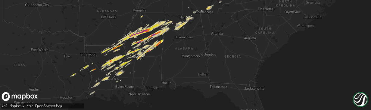
Hail Map in Alabama on November 29, 2016
The weather event in Alabama on November 29, 2016 includes Hail map. 6 states and 355 cities were impacted and suffered possible damage. The total estimated number of properties impacted is 0.
Want more than just the map?
Turn this storm into a full workflow.
- Owner + property data so you know who to knock
- OnDemand branded weather history reports to win the "did we even have hail?" argument
- RoofTrace estimate so reps stop guessing numbers at the door
Bought this map? Upgrade within 7 days and we'll credit the $230. (10-15 min setup call)
Hail
0
Estimated number of impacted properties by a 1.00" hail or larger0
Estimated number of impacted properties by a 1.75" hail or larger0
Estimated number of impacted properties by a 2.50" hail or largerStorm reports in Alabama
Alabama
| Date | Description |
|---|---|
| 11/29/201611:28 AM CST | Trees reported down along union grove road in morgan city. Possible tornado. |
| 11/29/201611:22 AM CST | Trees reported snapped near the top along pine ridge road in morgan city. |
| 11/29/201611:20 AM CST | Two people reported trapped in their storm shelter by fallen trees. Possible tornado. |
| 11/29/20165:18 AM CST | Trees down blocking cr 12 between faunsdale and newbern. . |
| 11/29/20165:10 AM CST | An ef1 tor with peak winds of 90mph touched down wsw of faunsdale and moved across far se hale co. Path length of 13 mi. Path width of 250 yds. The duration of the torn |
| 11/29/20163:00 AM CST | A local report indicates 1.75 inch wind near NNE JONES CHAPEL |
| 11/29/20162:48 AM CST | Public reported hail at home during storm that passed around 2:48 am the morning after tornado damaged home. |
| 11/29/20161:48 AM CST | Two large oak trees at a residence were snapped at about 25 feet above their base on tannahill drive in south huntsville. |
| 11/29/20161:10 AM CST | *** 7 inj *** an ef-3 tornado with peak wind speed of 145 mph... Path length of 7.5 miles and path width of 156 yards. This track will be adjusted after additional surv |
| 11/29/20161:04 AM CST | Roofs off sheds... Collapsed car ports... And damaged fences with cows out in nesmith. From previous evening storms. |
| 11/29/201612:40 AM CST | Speed measured by an aprs weather station at east lawrence high school. Relayed via ham radio operators. |
| 11/29/201612:26 AM CST | Roof torn off of a home along county road 159 north of ider. |
| 11/29/201612:25 AM CST | Numerous trees and powerlines down on alabama hwy 253. |
| 11/29/201612:20 AM CST | Roofs taken from houses on cagle road northeast of brilliant. Significant damage to a mobile home as well. Time based on radar... Via social media. |
| 11/29/201612:20 AM CST | Marion county sheriff's deputy confirms tornado crossed i-22 at mile marker 29. |
| 11/29/201612:10 AM CST | *** 7 inj *** an ef-3 tornado with peak wind speed of 145 mph... Path length of 7.5 miles and path width of 156 yards. This track will be adjusted after additional surv |
| 11/29/201612:10 AM CST | Multiple trees and powerlines reported down. Multiple injuries also reported. |
| 11/29/201612:04 AM CST | Roof blown off motel in guin. Time based on radar. |
| 11/29/201612:03 AM CST | Numerous chicken houses leveled to the ground. Gas station heavily damaged. |
| 11/29/201612:02 AM CST | Power lines and multiple trees down on co. Rd 88 in guin. |
| 11/29/201612:02 AM CST | *** 3 fatal *** an ef-2 tornado with peak wind speed of 127 mph... Path length of 1.7 miles... And path width of 204 yards. |
| 11/29/201612:02 AM CST | *** 3 fatal *** three comfirmed fatalities along county road 659 and highway 71 in rosalie. Macklin baptist church and rosalie plaza have also been completely destroyed |
| 11/29/201612:01 AM CST | An ef1 tor with peak winds of 90 mph touched down se of guin. Path length of 16.85 mi. Path width of 900yds. . The duration of the tornado event was 39 minutes. |
| 11/29/201612:00 AM CST | *** 2 fatal *** two comfirmed fatalities along county road 659 and highway 71 in rosalie. Macklin baptist church and rosalie plaza have also been completely destroyed. |
| 11/28/201611:57 PM CST | Powerlines reported down along pleasant valley road in union grove. Possible tornado. |
| 11/28/201611:47 PM CST | Trained spotter observed tornado go across the roadway in front of him on buck jackson road and morris road. Numerous trees down on the roadway. |
| 11/28/201611:45 PM CST | Structures damaged and numerous trees down on alabama highway 17 just south of sulligent... Near the lamar county airport. |
| 11/28/201611:40 PM CST | An ef1 tornado with peak winds of 105mph touched down wsw of the lamar county airport. Path length of 9.69 mi. . The duration of the tornado event was 13 minutes. |
| 11/28/201611:28 PM CST | Trees reported down along union grove road in morgan city. Possible tornado. |
| 11/28/201611:22 PM CST | Trees reported snapped near the top along pine ridge road in morgan city. Possible tornado. |
| 11/28/201611:22 PM CST | Trees reported snapped near the top along pine ridge road in morgan city. |
| 11/28/201611:20 PM CST | Two people reported trapped in their storm shelter by fallen trees. Possible tornado. |
| 11/28/201611:15 PM CST | Several homes with structural damage - one possibly destroyed. Other structures damaged. Possible tornado. |
| 11/28/201611:00 PM CST | A local report indicates 1.00 inch wind near E BRIDGEPORT |
| 11/28/201610:35 PM CST | Tree and road signs reported down along highway 278 just east of addison. |
| 11/28/201610:32 PM CST | Windows and roof damaged on a home. Damage also to a mobile home and barn. |
| 11/28/201610:20 PM CST | Windows and roof damaged on a home. Damage also to a mobile home and barn. |
| 11/28/201610:20 PM CST | An ef1 tor with peak winds of 110mph touched down nne of arley. Path length of 3.0 mi. Path width of 100yds. The duration of the tornado event was 5 minutes. |
| 11/28/20169:40 PM CST | Tornado spotted on the ground from buckhorn high school looking northeast. Relayed by ham radio operators. |
| 11/28/20169:30 PM CST | Structural damage reported around central school in ryland. Possible tornado. |
| 11/28/20169:30 PM CST | Significant structural damage at the flint ridge farm. Possible tornado. |
| 11/28/20169:30 PM CST | Significant structural damage at the flint ridge farm. |
| 11/28/20169:30 PM CST | Structural damage reported around central school in ryland. |
| 11/28/20169:29 PM CST | Ef-2 tornado with peak winds of 125 mph touched down along the west face of monte sano and continued for 11.5 miles...lifting along sharps cove road near the jackson co |
| 11/28/20169:28 PM CST | Numerous trees down along old chimney road. Ppssible tornado. |
| 11/28/20169:20 PM CST | Powerpole reported down along oakwood avenue in huntsville. Relayed via ham operator. |
| 11/28/20169:00 PM CST | Trees down along county road 946 in crane hill. |
| 11/28/20168:57 PM CST | Mobile home seriously damaged on county rd 77 in the helicon community. Multiple trees down. Possible tornado. Reported by helican fire. Via social media. Time based on |
| 11/28/20168:54 PM CST | An ef1 tornado with peak winds of 105mph touched down ese of arley. Path width of 300 yds and path length of 4.5 miles . The duration of the tornado event was 6 minutes |
| 11/28/20168:51 PM CST | Multiple trees down on county road 12 near arley... Via social media. Possible tornado. |
| 11/28/20168:45 PM CST | Fire station damaged in neel. Multiple trees and powerlines also down along the 5400 block of danville road near hartselle. Relayed by 911 center via ham operator. |
| 11/28/20168:45 PM CST | Structural damage reported in the neel community. Homes damaged. |
| 11/28/20168:45 PM CST | On herring road in hartselle. Tree tops twisted off. Home heavily damaged with roof torn apart. Possible tornado. |
| 11/28/20168:25 PM CST | Damage on hwy 44 about 2 mi out of guin... Shed gone... House damage & vehicle damage from down trees. Possible tornado. Time based on radar. |
| 11/28/20168:08 PM CST | Structure damage reported in the ashridge community. Garage completely destroyed... Collapsing on vehicles. Relayed via social media. Possible tornado. Time based on ra |
| 11/28/20168:08 PM CST | Roof blown off of home on county rd 2 off of al 195. Possible tornado. Reported by ash ridge fd. Via social media. |
| 11/28/20168:06 PM CST | An ef2 tor with peak winds of 125mph touched down s of ashridge. Path length of 3.2 mi. Path width of 300yds. The duration of the tornado event was 6 minutes. |
| 11/28/20168:04 PM CST | Several trees and powerlines down in brilliant. Possible tornado. |
| 11/28/20168:04 PM CST | An ef0 tor with peak winds of 65 mph touched down briefly sw of fowlers crossroads. Path length of 0.3 mi. Path width of 50 yds. The duration of the tornado event was 1 |
| 11/28/20168:04 PM CST | An ef1 tornado touched down e of haleyville with peak winds of 100-105mph. Path width of 100 yds... Path length of 0.4 miles. The duration of the tornado event was 2 mi |
| 11/28/20167:38 PM CST | Barn damage |
| 11/28/20167:36 PM CST | Trees blocking the roadway on county road 34 north of u.s. Highway 82. Possible tornado. |
| 11/28/20167:30 PM CST | Numerous trees and powerlines down along underwood mountain road in tuscumbia. Home damaged as well with two injuries. Possible tornado. Relayed by colbert eoc. |
| 11/28/20167:30 PM CST | Numerous trees and powerlines down along underwood mountain road in tuscumbia. Home damaged as well with two injuries. Possible tornado. Relayed by colbert eoc. |
| 11/28/20167:29 PM CST | An ef0 tor with peak winds of 75mph touched down ne of gu-win. Path length of 10.6 mi. Path width of 150 yds. The duration of the tornado event was 14 minutes. |
| 11/28/20167:20 PM CST | Trees blocking the roadway on county road 34 north of u.s. Highway 82. Possible tornado. Corrected time. |
| 11/28/20167:15 PM CST | Trees down along frankfort and wagnon mountain roads. Relayed by colbert eoc. |
| 11/28/20167:15 PM CST | An ef1 with peak winds of 95 mph touched down ne of ethelsville. Path width of 600 yds and path length of 5.3 miles. The duration of the tornado event was 10 minutes. |
| 11/28/20167:15 PM CST | Trees down along frankfort and wagnon mountain roads. Relayed by colbert eoc. |
| 11/28/20167:05 PM CST | *** 3 inj *** an ef-2 tornado with peak winds of 115 mph...maximum path width of 100 yards...and a path length of 11 miles. |
All States Impacted by Hail Map on November 29, 2016
Cities Impacted by Hail Map on November 29, 2016
- Columbia, LA
- Olla, LA
- Delhi, LA
- Winnfield, LA
- Baskin, LA
- Kelly, LA
- Tullos, LA
- Mangham, LA
- Winnsboro, LA
- Grayson, LA
- Dubach, LA
- Eupora, MS
- Mathiston, MS
- Georgetown, TN
- Birchwood, TN
- Cleveland, TN
- Harrison, TN
- Ooltewah, TN
- Decatur, TN
- Soddy Daisy, TN
- Laceys Spring, AL
- Union Grove, AL
- Edwards, MS
- Double Springs, AL
- Houston, AL
- Oakland, MS
- Mer Rouge, LA
- Bastrop, LA
- Falkville, AL
- Pheba, MS
- Mantee, MS
- Choudrant, LA
- Farmerville, LA
- Ruston, LA
- Downsville, LA
- Bolton, MS
- Clinton, MS
- Deville, LA
- Jonesville, LA
- Jena, LA
- Oxford, MS
- Paris, MS
- Water Valley, MS
- Thaxton, MS
- Etta, MS
- Somerville, AL
- Coffeeville, MS
- Hermanville, MS
- Utica, MS
- Dry Creek, LA
- Ragley, LA
- Deridder, LA
- Brandon, MS
- Pelahatchie, MS
- Cleveland, MS
- Mooreville, MS
- Bruce, MS
- Indianola, MS
- Sunflower, MS
- Tupelo, MS
- Greenwood, MS
- Holcomb, MS
- Belden, MS
- Calhoun City, MS
- Pontotoc, MS
- Tillatoba, MS
- Vardaman, MS
- Shannon, MS
- Verona, MS
- Leland, MS
- Golden, MS
- Philipp, MS
- Doddsville, MS
- Fulton, MS
- Scobey, MS
- Houlka, MS
- Schlater, MS
- Mantachie, MS
- Marietta, MS
- Cascilla, MS
- Shaw, MS
- Randolph, MS
- Ruleville, MS
- Plantersville, MS
- Saltillo, MS
- Pittsboro, MS
- Grenada, MS
- Minter City, MS
- Big Creek, MS
- Ferriday, LA
- Lake Charles, LA
- Sulphur, LA
- Hackberry, LA
- Richland, MS
- Pearl, MS
- Florence, MS
- Macon, MS
- Louisville, MS
- Brooksville, MS
- Shuqualak, MS
- Columbus, MS
- Preston, MS
- Philadelphia, MS
- Carthage, MS
- Walnut Grove, MS
- Eudora, AR
- Oak Grove, LA
- Jones, LA
- Bonita, LA
- Maben, MS
- Cedarbluff, MS
- Enid, MS
- Charleston, MS
- Cullman, AL
- Vinemont, AL
- Center, TX
- Canton, MS
- Madison, MS
- Lorman, MS
- Waterproof, LA
- Port Gibson, MS
- Kosciusko, MS
- Ethel, MS
- Sallis, MS
- Russellville, AL
- Phil Campbell, AL
- Vina, AL
- Hodges, AL
- Spruce Pine, AL
- Florien, LA
- Many, LA
- Forest Hill, LA
- Glenmora, LA
- Oakdale, LA
- Hartselle, AL
- Eva, AL
- Trout, LA
- Sherwood, TN
- Belvidere, TN
- Cruger, MS
- Lexington, MS
- Tchula, MS
- Yazoo City, MS
- Princeton, AL
- Hollytree, AL
- Union, MS
- Lena, MS
- Flowood, MS
- Morton, MS
- Mittie, LA
- Addison, AL
- Danville, AL
- Calhoun, LA
- Eros, LA
- Vicksburg, MS
- Redwood, MS
- Benton, MS
- Vaughan, MS
- Satartia, MS
- Bentonia, MS
- Brownsboro, AL
- Gurley, AL
- Hamilton, AL
- Coila, MS
- Winona, MS
- Vaiden, MS
- Shelbyville, TX
- Noble, LA
- San Augustine, TX
- Converse, LA
- Lecompte, LA
- Bunkie, LA
- Cheneyville, LA
- Saint Landry, LA
- Ville Platte, LA
- Pelican, LA
- Moulton, AL
- Hamilton, MS
- West, MS
- French Camp, MS
- Weir, MS
- Parkdale, AR
- Portland, AR
- Groveton, TX
- Apple Springs, TX
- Diboll, TX
- Huntsville, TX
- Simsboro, LA
- Marion, LA
- Robeline, LA
- Greenville, MS
- Aberdeen, MS
- Prairie, MS
- Woodville, AL
- Boyle, MS
- Mound Bayou, MS
- Merigold, MS
- Silver City, MS
- Belzoni, MS
- Pioneer, LA
- Arcadia, LA
- Dry Prong, LA
- Colfax, LA
- Durant, MS
- Kilmichael, MS
- Gilbert, LA
- Georgetown, LA
- Atlanta, LA
- Tallulah, LA
- Sikes, LA
- Newellton, LA
- Cameron, LA
- Owens Cross Roads, AL
- Huntsville, AL
- Starkville, MS
- West Point, MS
- Okolona, MS
- Itta Bena, MS
- Lake Village, AR
- Houston, MS
- Gore Springs, MS
- Dennis, MS
- Belmont, MS
- Guntown, MS
- Blue Springs, MS
- Valley Park, MS
- Rolling Fork, MS
- Gattman, MS
- McDonald, TN
- Calhoun, TN
- Hixson, TN
- Longville, LA
- Saint Francisville, LA
- Wilmot, AR
- Logan, AL
- Noxapater, MS
- Nettleton, MS
- Ackerman, MS
- Arley, AL
- Camden, MS
- Amory, MS
- Stewart, MS
- Tremont, MS
- Detroit, AL
- Guin, AL
- Greenwood Springs, MS
- Caledonia, MS
- Beaverton, AL
- Sulligent, AL
- Moreauville, LA
- Clayton, LA
- Saint Joseph, LA
- Natchez, MS
- Fayette, MS
- Woodland, MS
- Louise, MS
- Walthall, MS
- Benoit, MS
- Banner, MS
- Drew, MS
- Montrose, AR
- Red Bay, AL
- Baldwyn, MS
- New Site, MS
- Sterlington, LA
- New Hope, AL
- Paint Rock, AL
- Hackleburg, AL
- Crawford, MS
- Braxton, MS
- Lake Providence, LA
- Hernando, MS
- Coldwater, MS
- Chireno, TX
- Lufkin, TX
- Sewanee, TN
- Riceville, TN
- Athens, TN
- Sale Creek, TN
- Charleston, TN
- Inverness, MS
- Whitwell, TN
- Woodville, MS
- Vidalia, LA
- Monterey, LA
- Crosby, MS
- Nauvoo, AL
- Crane Hill, AL
- Jasper, AL
- Sicily Island, LA
- McCool, MS
- Pineville, LA
- Alexandria, LA
- Oak Ridge, LA
- Pollock, LA
- Tutwiler, MS
- West Monroe, LA
- Bogue Chitto, MS
- Summit, MS
- Ridgeland, MS
- Derma, MS
- Pope, MS
- Hamburg, AR
- Taylor, MS
- Courtland, MS
- Scottsboro, AL
- Simmesport, LA
- Center Point, LA
- Pattison, MS
- Hazlehurst, MS
- Harrisonburg, LA
- Aimwell, LA
- Bentley, LA
- Lena, LA
- Cloutierville, LA
- Montgomery, LA
- Monroe, LA
- Batesville, MS
- Forest, MS
- Quitman, LA
- Coushatta, LA
- Fisher, LA
- Provencal, LA
- Crossett, AR
- Hanceville, AL
- Sidon, MS
- Baileyton, AL
- Jackson, MS
- Byram, MS
- Collinston, LA
- Dequincy, LA
- Kinder, LA
- Reeves, LA
- Trenton, AL
- Fayetteville, TN
- Pickens, MS
- Flora, MS
- Greenback, TN
- Maryville, TN
- Vonore, TN
- Melville, LA
- Batchelor, LA
- Roxie, MS
- Acme, LA
- Marksville, LA
- Sturgis, MS
- Smithville, MS
- Vernon, AL
- Moorhead, MS
- Glendora, MS
- Liberty, MS
- Smithdale, MS
- Raymond, MS
- Bernice, LA
- Effie, LA


