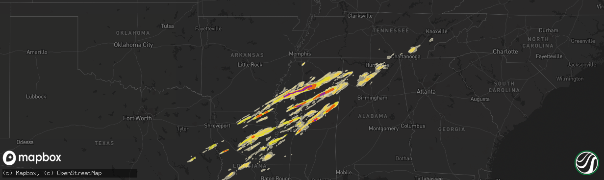
Hail Map on November 29, 2016
The weather event on November 29, 2016 includes Hail map. 6 states and 355 cities were impacted and suffered possible damage. The total estimated number of properties impacted is 76,406.
Want more than just the map?
Turn this storm into a full workflow.
- Owner + property data so you know who to knock
- OnDemand branded weather history reports to win the "did we even have hail?" argument
- RoofTrace estimate so reps stop guessing numbers at the door
Bought this map? Upgrade within 7 days and we'll credit the $230. (10-15 min setup call)
Hail
76,406
Estimated number of impacted properties by a 1.00" hail or larger21,263
Estimated number of impacted properties by a 1.75" hail or larger2,081
Estimated number of impacted properties by a 2.50" hail or largerStorm reports
Alabama
| Date | Description |
|---|---|
| 11/29/201611:28 AM CST | Trees reported down along union grove road in morgan city. Possible tornado. |
| 11/29/201611:22 AM CST | Trees reported snapped near the top along pine ridge road in morgan city. |
| 11/29/201611:20 AM CST | Two people reported trapped in their storm shelter by fallen trees. Possible tornado. |
| 11/29/20165:18 AM CST | Trees down blocking cr 12 between faunsdale and newbern. . |
| 11/29/20165:10 AM CST | An ef1 tor with peak winds of 90mph touched down wsw of faunsdale and moved across far se hale co. Path length of 13 mi. Path width of 250 yds. The duration of the torn |
| 11/29/20163:00 AM CST | A local report indicates 1.75 inch wind near NNE JONES CHAPEL |
| 11/29/20162:48 AM CST | Public reported hail at home during storm that passed around 2:48 am the morning after tornado damaged home. |
| 11/29/20161:48 AM CST | Two large oak trees at a residence were snapped at about 25 feet above their base on tannahill drive in south huntsville. |
| 11/29/20161:10 AM CST | *** 7 inj *** an ef-3 tornado with peak wind speed of 145 mph... Path length of 7.5 miles and path width of 156 yards. This track will be adjusted after additional surv |
| 11/29/20161:04 AM CST | Roofs off sheds... Collapsed car ports... And damaged fences with cows out in nesmith. From previous evening storms. |
| 11/29/201612:40 AM CST | Speed measured by an aprs weather station at east lawrence high school. Relayed via ham radio operators. |
| 11/29/201612:26 AM CST | Roof torn off of a home along county road 159 north of ider. |
| 11/29/201612:25 AM CST | Numerous trees and powerlines down on alabama hwy 253. |
| 11/29/201612:20 AM CST | Marion county sheriff's deputy confirms tornado crossed i-22 at mile marker 29. |
| 11/29/201612:20 AM CST | Roofs taken from houses on cagle road northeast of brilliant. Significant damage to a mobile home as well. Time based on radar... Via social media. |
| 11/29/201612:10 AM CST | Multiple trees and powerlines reported down. Multiple injuries also reported. |
| 11/29/201612:10 AM CST | *** 7 inj *** an ef-3 tornado with peak wind speed of 145 mph... Path length of 7.5 miles and path width of 156 yards. This track will be adjusted after additional surv |
| 11/29/201612:04 AM CST | Roof blown off motel in guin. Time based on radar. |
| 11/29/201612:03 AM CST | Numerous chicken houses leveled to the ground. Gas station heavily damaged. |
| 11/29/201612:02 AM CST | *** 3 fatal *** three comfirmed fatalities along county road 659 and highway 71 in rosalie. Macklin baptist church and rosalie plaza have also been completely destroyed |
| 11/29/201612:02 AM CST | *** 3 fatal *** an ef-2 tornado with peak wind speed of 127 mph... Path length of 1.7 miles... And path width of 204 yards. |
| 11/29/201612:02 AM CST | Power lines and multiple trees down on co. Rd 88 in guin. |
| 11/29/201612:01 AM CST | An ef1 tor with peak winds of 90 mph touched down se of guin. Path length of 16.85 mi. Path width of 900yds. . The duration of the tornado event was 39 minutes. |
| 11/29/201612:00 AM CST | *** 2 fatal *** two comfirmed fatalities along county road 659 and highway 71 in rosalie. Macklin baptist church and rosalie plaza have also been completely destroyed. |
| 11/28/201611:57 PM CST | Powerlines reported down along pleasant valley road in union grove. Possible tornado. |
| 11/28/201611:47 PM CST | Trained spotter observed tornado go across the roadway in front of him on buck jackson road and morris road. Numerous trees down on the roadway. |
| 11/28/201611:45 PM CST | Structures damaged and numerous trees down on alabama highway 17 just south of sulligent... Near the lamar county airport. |
| 11/28/201611:40 PM CST | An ef1 tornado with peak winds of 105mph touched down wsw of the lamar county airport. Path length of 9.69 mi. . The duration of the tornado event was 13 minutes. |
| 11/28/201611:28 PM CST | Trees reported down along union grove road in morgan city. Possible tornado. |
| 11/28/201611:22 PM CST | Trees reported snapped near the top along pine ridge road in morgan city. |
| 11/28/201611:22 PM CST | Trees reported snapped near the top along pine ridge road in morgan city. Possible tornado. |
| 11/28/201611:20 PM CST | Two people reported trapped in their storm shelter by fallen trees. Possible tornado. |
| 11/28/201611:15 PM CST | Several homes with structural damage - one possibly destroyed. Other structures damaged. Possible tornado. |
| 11/28/201611:00 PM CST | A local report indicates 1.00 inch wind near E BRIDGEPORT |
| 11/28/201610:35 PM CST | Tree and road signs reported down along highway 278 just east of addison. |
| 11/28/201610:32 PM CST | Windows and roof damaged on a home. Damage also to a mobile home and barn. |
| 11/28/201610:20 PM CST | An ef1 tor with peak winds of 110mph touched down nne of arley. Path length of 3.0 mi. Path width of 100yds. The duration of the tornado event was 5 minutes. |
| 11/28/201610:20 PM CST | Windows and roof damaged on a home. Damage also to a mobile home and barn. |
| 11/28/20169:40 PM CST | Tornado spotted on the ground from buckhorn high school looking northeast. Relayed by ham radio operators. |
| 11/28/20169:30 PM CST | Structural damage reported around central school in ryland. |
| 11/28/20169:30 PM CST | Significant structural damage at the flint ridge farm. |
| 11/28/20169:30 PM CST | Structural damage reported around central school in ryland. Possible tornado. |
| 11/28/20169:30 PM CST | Significant structural damage at the flint ridge farm. Possible tornado. |
| 11/28/20169:29 PM CST | Ef-2 tornado with peak winds of 125 mph touched down along the west face of monte sano and continued for 11.5 miles...lifting along sharps cove road near the jackson co |
| 11/28/20169:28 PM CST | Numerous trees down along old chimney road. Ppssible tornado. |
| 11/28/20169:20 PM CST | Powerpole reported down along oakwood avenue in huntsville. Relayed via ham operator. |
| 11/28/20169:00 PM CST | Trees down along county road 946 in crane hill. |
| 11/28/20168:57 PM CST | Mobile home seriously damaged on county rd 77 in the helicon community. Multiple trees down. Possible tornado. Reported by helican fire. Via social media. Time based on |
| 11/28/20168:54 PM CST | An ef1 tornado with peak winds of 105mph touched down ese of arley. Path width of 300 yds and path length of 4.5 miles . The duration of the tornado event was 6 minutes |
| 11/28/20168:51 PM CST | Multiple trees down on county road 12 near arley... Via social media. Possible tornado. |
| 11/28/20168:45 PM CST | On herring road in hartselle. Tree tops twisted off. Home heavily damaged with roof torn apart. Possible tornado. |
| 11/28/20168:45 PM CST | Structural damage reported in the neel community. Homes damaged. |
| 11/28/20168:45 PM CST | Fire station damaged in neel. Multiple trees and powerlines also down along the 5400 block of danville road near hartselle. Relayed by 911 center via ham operator. |
| 11/28/20168:25 PM CST | Damage on hwy 44 about 2 mi out of guin... Shed gone... House damage & vehicle damage from down trees. Possible tornado. Time based on radar. |
| 11/28/20168:08 PM CST | Roof blown off of home on county rd 2 off of al 195. Possible tornado. Reported by ash ridge fd. Via social media. |
| 11/28/20168:08 PM CST | Structure damage reported in the ashridge community. Garage completely destroyed... Collapsing on vehicles. Relayed via social media. Possible tornado. Time based on ra |
| 11/28/20168:06 PM CST | An ef2 tor with peak winds of 125mph touched down s of ashridge. Path length of 3.2 mi. Path width of 300yds. The duration of the tornado event was 6 minutes. |
| 11/28/20168:04 PM CST | An ef0 tor with peak winds of 65 mph touched down briefly sw of fowlers crossroads. Path length of 0.3 mi. Path width of 50 yds. The duration of the tornado event was 1 |
| 11/28/20168:04 PM CST | An ef1 tornado touched down e of haleyville with peak winds of 100-105mph. Path width of 100 yds... Path length of 0.4 miles. The duration of the tornado event was 2 mi |
| 11/28/20168:04 PM CST | Several trees and powerlines down in brilliant. Possible tornado. |
| 11/28/20167:38 PM CST | Barn damage |
| 11/28/20167:36 PM CST | Trees blocking the roadway on county road 34 north of u.s. Highway 82. Possible tornado. |
| 11/28/20167:30 PM CST | Numerous trees and powerlines down along underwood mountain road in tuscumbia. Home damaged as well with two injuries. Possible tornado. Relayed by colbert eoc. |
| 11/28/20167:30 PM CST | Numerous trees and powerlines down along underwood mountain road in tuscumbia. Home damaged as well with two injuries. Possible tornado. Relayed by colbert eoc. |
| 11/28/20167:29 PM CST | An ef0 tor with peak winds of 75mph touched down ne of gu-win. Path length of 10.6 mi. Path width of 150 yds. The duration of the tornado event was 14 minutes. |
| 11/28/20167:20 PM CST | Trees blocking the roadway on county road 34 north of u.s. Highway 82. Possible tornado. Corrected time. |
| 11/28/20167:15 PM CST | An ef1 with peak winds of 95 mph touched down ne of ethelsville. Path width of 600 yds and path length of 5.3 miles. The duration of the tornado event was 10 minutes. |
| 11/28/20167:15 PM CST | Trees down along frankfort and wagnon mountain roads. Relayed by colbert eoc. |
| 11/28/20167:15 PM CST | Trees down along frankfort and wagnon mountain roads. Relayed by colbert eoc. |
| 11/28/20167:05 PM CST | *** 3 inj *** an ef-2 tornado with peak winds of 115 mph...maximum path width of 100 yards...and a path length of 11 miles. |
Tennessee
| Date | Description |
|---|---|
| 11/29/20165:30 AM CST | Few trees down on the west side of chattanooga. |
| 11/29/20165:25 AM CST | Few trees down. |
| 11/29/20165:20 AM CST | Trees down across the county. |
| 11/29/20164:45 AM CST | Numerous trees down countywide. |
| 11/29/20164:35 AM CST | 1 roof removed completely from home. Roof damage to another home as well as a barn. |
| 11/29/20164:30 AM CST | Several trees down in knoxville. |
| 11/29/20164:25 AM CST | Trees down. |
| 11/29/20164:20 AM CST | Trees down |
| 11/29/20164:15 AM CST | Several trees down and a out building blown over. |
| 11/29/20164:00 AM CST | Trees and power lines down in the athens area. Widespread power outages. |
| 11/29/20163:30 AM CST | Trees down in the decatur area. |
| 11/29/20163:30 AM CST | Trees down. |
| 11/29/20162:50 AM CST | Trees and power lines down. |
| 11/29/20162:30 AM CST | Trees and power lines down. |
| 11/29/20162:20 AM CST | Building damage reported at knox glass company. |
| 11/29/20162:18 AM CST | Power lines down on lakes road east of tracy city |
| 11/29/20162:13 AM CST | A carport was blown off of mountain auto services on the grundy county side into power lowers. In addition... There server several trees down along highway 41 in the sa |
| 11/29/20162:11 AM CST | A carport was blown off into power lines at mountain auto services on highway 41 just east of monteagle. In addition...several trees and power lines were blown down alo |
| 11/29/20162:00 AM CST | Several trees down. |
| 11/29/20161:30 AM CST | Structural damage to several buildings along hwy 411 and stump street. |
| 11/29/20161:28 AM CST | The tornado formed south of ocoee with several large trees snapped. It strengthened rapidly to an ef-2 and moved north northeast and collapsed a cell phone tower. It th |
| 11/29/20161:25 AM CST | A local report indicates 60 MPH wind near 3 SSW CLEVELAND |
| 11/29/20161:08 AM CST | Power lines down. |
| 11/29/201612:42 AM CST | Trees uprooted and hole in roof of residence. |
| 11/29/201612:30 AM CST | Report relayed from amateur radio and dispatch. There is damage extending along a line from county road 700... Across athens... And continuing up hwy 307. Multiple repo |
| 11/29/201612:30 AM CST | Several homes destroyed in deerfield estates. Injuries reported...but no further details at this point. |
| 11/29/201612:21 AM CST | At state road 30 and 39 intersection in athens roof blown off building. Trees down... Structures damaged and roads blocked south of athens. |
| 11/29/201612:20 AM CST | *** 20 inj *** the tornado developed near the intersection of county road 700 and 705 where there was some minor tree damage observed. The tornado continued to the nort |
| 11/29/201612:00 AM CST | Doors blown off church building and power lines down. |
| 11/28/201611:48 PM CST | Trees and power lines down. |
| 11/28/201611:45 PM CST | Trees and power lines down. |
| 11/28/201611:40 PM CST | Trees and power lines down. |
| 11/28/201611:33 PM CST | Power lines down on 20th ave north near bouldin road |
| 11/28/201611:30 PM CST | 2 semi truck trailers overturned. Damage to several structures... And trees down across the county |
| 11/28/201611:15 PM CST | Trees and power lines down. |
| 11/28/201611:10 PM CST | Roof blown off house and windows blown out at 5071 alvin york hwy. Powell crossroads area. Minor damage to another house. Power lines down. 2 chicken houses destroyed. |
| 11/28/201611:10 PM CST | Trees down in the new hope community. |
| 11/28/201611:03 PM CST | Tornado formed in far northern marion county...about 1/2 mile from sequatchie county. Quickly intensified to strong ef-2 tornado...with winds of 130 mph. Double wide mo |
| 11/28/201610:45 PM CST | A few trees and large tree limbs down. |
| 11/28/201610:35 PM CST | Tree down on an abandoned home. The home is pretty much destroyed. Powerlines also reported down. |
| 11/28/20169:24 PM CST | Ef-1 tornado...estimated peak wind speed of 105 mph...with a path length of 3.5 miles...and a maximum path width of 200 yards...started 1.6 miles se of manchester at 92 |
| 11/28/20169:14 PM CST | Spotter reported a tornado northeast of tullahoma near hwy 55 with debri and pea sized hail |
| 11/28/20169:12 PM CST | Tullahoma asos recorded 51 knot gust |
| 11/28/20169:09 PM CST | Multiple trees and power lines were downed across the north end of tullahoma. |
| 11/28/20169:08 PM CST | Portions of tullahoma mcdonalds roof blown away |
| 11/28/20169:07 PM CST | Large tree down and blocking road on golf club lane in tullahoma |
| 11/28/20169:07 PM CST | Tspotter report of trees and power lines down in the sharondale area of tullahoma. |
| 11/28/20169:07 PM CST | Tree down across cedar street in tullahoma. Road impassable |
| 11/28/20169:07 PM CST | Roof damage to strip mall along n jackson street in tullahoma |
| 11/28/20169:07 PM CST | Tree fell on house near lakewood country club in tullahoma |
| 11/28/20169:06 PM CST | Ef1 tornado. Winds around 105mph. Numerous trees down. Several houses damaged by falling trees. |
| 11/28/20169:06 PM CST | House destroyed and trees down in the sharondale area in tullahoma possible tornado |
| 11/28/20169:05 PM CST | *** 1 inj *** an ef-1 tornado...estimated peak wind speed of 105 mph....with a path length of 8 miles...and a maximum path width of 300 yards...started 2.4 miles w of t |
Georgia
| Date | Description |
|---|---|
| 11/29/201612:57 AM CST | A tornado associated with a discrete supercell produced a small area of damage northeast of ringgold... Specifically along cherokee valley road and swallow lane... Seve |
| 11/29/201612:21 AM CST | 911 center reported multiple trees down along gass road and hwy 136. Road crews were called out to clear roadway. Time estimated from radar. |
Mississippi
| Date | Description |
|---|---|
| 11/29/20165:56 PM CST | Trees down on butler road |
| 11/29/20165:55 PM CST | A local report indicates 1.00 inch wind near GRENADA |
| 11/29/20165:55 PM CST | Multiple trees down along the entrance road to hugh white state park. |
| 11/29/20165:53 PM CST | A local report indicates 1.00 inch wind near 5 SW TUPELO |
| 11/29/20165:52 PM CST | Tornado started near skinner road and traveled 3.5 miles nne before lifting after crossing robinson road. Minor to moderate tree damage was mixed with a few instances o |
| 11/29/20165:50 PM CST | 4 homes destroyed on ebenezer church road and 2 structures on county line road |
| 11/29/20165:50 PM CST | A local report indicates 1.75 inch wind near 1 WSW MONTPELIER |
| 11/29/20165:49 PM CST | Tornado touched down on c mcdonald rd in winston county and tracked into noxubee county. It caused damage to trees and homes near jr boy goodin rd. It peaked as it cros |
| 11/29/20165:40 PM CST | Two mobile homes damaged on county line rd. |
| 11/29/20165:35 PM CST | A local report indicates 1.75 inch wind near 5 E WALTHALL |
| 11/29/20165:33 PM CST | Trees down. |
| 11/29/20165:25 PM CST | A couple power lines down near money |
| 11/29/20165:10 PM CST | Power lines reported down across calhoun county. Time estimated from radar. |
| 11/29/20165:00 PM CST | Swath of wind damage from hwy 51 to mcswine road and then into tallahatchie county. There was some structural damage to homes along mcswine road. |
| 11/29/20165:00 PM CST | A local report indicates 1.00 inch wind near BENTONIA |
| 11/29/20164:50 PM CST | Marble to up to baseball sized hail was observed between hope and laurel hill |
| 11/29/20164:41 PM CST | A local report indicates 2.00 inch wind near 2 W MADDEN |
| 11/29/20164:40 PM CST | Home completely destroyed by fallen tree. |
| 11/29/20164:35 PM CST | Multiple trees were snapped near the walnut grove correctional facility. Possible tornado damage. |
| 11/29/20164:31 PM CST | A local report indicates 1.00 inch wind near 5 NE REDWOOD |
| 11/29/20164:30 PM CST | A local report indicates 1.00 inch wind near VAIDEN |
| 11/29/20164:30 PM CST | A local report indicates 1.50 inch wind near WALNUT GROVE |
| 11/29/20164:24 PM CST | A local report indicates 1.00 inch wind near GRENADA |
| 11/29/20164:23 PM CST | A local report indicates 1.00 inch wind near 5 N GRENADA |
| 11/29/20164:22 PM CST | Numerous trees were downed across the northwest portions of the county near mcswine and pea ridge road. The strong winds also caused roof and window damage to some home |
| 11/29/20164:22 PM CST | Scattered trees were blown down across the north west and east portions of the county. City of grenada had some trees blown down. A house received some major damage on |
| 11/29/20164:15 PM CST | Also some minor street flooding occurred with winds speed estimated at around 50 mph. Small tree limbs were on the ground. |
| 11/29/20164:11 PM CST | On highway 13 trees and power poles were blown down. |
| 11/29/20164:02 PM CST | Trees and power lines are down in its path. |
| 11/29/20164:00 PM CST | A 250 to 300 yard swath of damage from highway 481 to debates road... Roof damage on mejelk road. On renfore road a tree had fallen on a mobile home. Trees were blown d |
| 11/29/20164:00 PM CST | A local report indicates 1.00 inch wind near TCHULA |
| 11/29/20163:59 PM CST | Trees were blown down in the area. |
| 11/29/20163:57 PM CST | A local report indicates 1.75 inch wind near 1 N TCHULA |
| 11/29/20163:57 PM CST | Tornado started near the intersection of leesburg rd and harrell rd in rankin county producing ef-0 damage before traveling into northern scott county where ef-1 damage |
| 11/29/20163:57 PM CST | Multiple trees down around the tchula area. |
| 11/29/20163:51 PM CST | Penny to quarter sized hail occurred south of canton. |
| 11/29/20163:24 PM CST | A local report indicates 2.75 inch wind near 5 SW DODDSVILLE |
| 11/29/20163:24 PM CST | A local report indicates 1.25 inch wind near 2 W BRANDON |
| 11/29/20163:20 PM CST | A local report indicates 1.75 inch wind near 4 W BRANDON |
| 11/29/20162:50 PM CST | A local report indicates 1.25 inch wind near METCALFE |
| 11/29/20162:10 PM CST | A local report indicates 1.00 inch wind near 1 N PORT GIBSON |
| 11/29/20161:50 PM CST | Quarter sized hail occurred on the alcorn state university campus. |
| 11/29/201612:54 AM CST | Social media picture of siding blown off a home on the west side of starkville. |
| 11/29/201612:34 AM CST | Large highway sign broken off just north of the shell station on us 45. |
| 11/28/201611:49 PM CST | Multiple trees down along hwy 15 between noxapater and the neshoba/winston county line. Possible tornado. |
| 11/28/201611:00 PM CST | Near palo alto...the porch of a home was damaged...and a trampoline and large play set in the yard were destroyed. |
| 11/28/201610:15 PM CST | Trees were down just east of tchula |
| 11/28/20169:45 PM CST | Power lines down along highway 3. Possible tornado |
| 11/28/20168:28 PM CST | Spotter reports visual confirmation of tornado in lowndes county |
| 11/28/20168:20 PM CST | This tornado traveled nne just southwest of columbus for a distance of 2.9 miles mostly doing minor to moderate tree damage. One farm pivot was heavily damaged near the |
| 11/28/20166:55 PM CST | A tree fell on a home causing roof damage and some structural damage. |
| 11/28/20166:25 PM CST | Roof damage. Multiple vehicles damaged along highway 25 near homestead road and binford road. |
| 11/28/20166:23 PM CST | A local report indicates 1.25 inch wind near PITTSBORO |
| 11/28/20166:23 PM CST | Roof blown off at discount grocery near the dock. |
| 11/28/20166:23 PM CST | Mostly nickel hail with a few quarters mixed in. |
| 11/28/20166:21 PM CST | A local report indicates 1.00 inch wind near PITTSBORO |
| 11/28/20166:20 PM CST | Chimney off house. Two outbuildings picked up and moved off foundation. Power poles snapped and tree tops and limbs snapped off and twisted. |
| 11/28/20166:15 PM CST | Tornado traveled roughly 3 miles northeast through the northern portion of clay county before exiting into monroe county covered by nws meg. Mostly minor to moderate tr |
Louisiana
| Date | Description |
|---|---|
| 11/29/20165:35 PM CST | Public reports quarter size hail in the vowells mill community...via ksla-tv facebook page. |
| 11/29/20165:30 PM CST | Near highway 127 in olla at the olla grocery. |
| 11/29/20165:08 PM CST | A local report indicates 1.00 inch wind near LIDDIEVILLE |
| 11/29/20165:02 PM CST | Trees down along 123 northeast of dry prong. |
| 11/29/20164:29 PM CST | A local report indicates 1.00 inch wind near LIDDIEVILLE |
| 11/29/20164:20 PM CST | A local report indicates 1.00 inch wind near LIDDIEVILLE |
| 11/29/20164:15 PM CST | Small limbs were blown down which had caused some scattered power outages. |
| 11/29/20163:57 PM CST | Trees down along 165 between grayson and columbia. |
| 11/29/20163:55 PM CST | Golfball size hail in the town of grayson. |
| 11/29/20163:43 PM CST | Tornado reported on 165 and 506 near the town of kelly |
| 11/29/20163:43 PM CST | Tornado reported on 165 and 506 near the town of kelly. |
| 11/29/20163:17 PM CST | In the town of vienna. |
| 11/29/20162:55 PM CST | Reported on erskin road |
| 11/28/201611:45 PM CST | Relayed by local media...entergy reports 3 power pole structures fell down from wind near burton shipyard road and highway 27 south of carlyss. |
| 11/28/20169:40 PM CST | Large limbs and power lines were down resulting in power outages. |
| 11/28/20169:20 PM CST | Trees down off hwy 8 on sparrow road. |
| 11/28/20169:20 PM CST | Trees down along hwy 84 in the town of jena. |
| 11/28/20167:57 PM CST | At chase |
| 11/28/20166:20 PM CST | A local report indicates 1.75 inch wind near GALION |
Texas
| Date | Description |
|---|---|
| 11/29/201610:15 AM CST | Quarter to half dollar size hail reported at jordans store... Tx. |
| 11/29/20168:57 AM CST | Public post photo of hail on ktre-tv facebook page. |
Arkansas
| Date | Description |
|---|---|
| 11/29/20163:17 PM CST | In the town of diana |
Cities Impacted by Hail Map on November 29, 2016
- Columbia, LA
- Olla, LA
- Delhi, LA
- Winnfield, LA
- Baskin, LA
- Kelly, LA
- Tullos, LA
- Mangham, LA
- Winnsboro, LA
- Grayson, LA
- Dubach, LA
- Eupora, MS
- Mathiston, MS
- Georgetown, TN
- Birchwood, TN
- Cleveland, TN
- Harrison, TN
- Ooltewah, TN
- Decatur, TN
- Soddy Daisy, TN
- Laceys Spring, AL
- Union Grove, AL
- Edwards, MS
- Double Springs, AL
- Houston, AL
- Oakland, MS
- Mer Rouge, LA
- Bastrop, LA
- Falkville, AL
- Pheba, MS
- Mantee, MS
- Choudrant, LA
- Farmerville, LA
- Ruston, LA
- Downsville, LA
- Bolton, MS
- Clinton, MS
- Deville, LA
- Jonesville, LA
- Jena, LA
- Oxford, MS
- Paris, MS
- Water Valley, MS
- Thaxton, MS
- Etta, MS
- Somerville, AL
- Coffeeville, MS
- Hermanville, MS
- Utica, MS
- Dry Creek, LA
- Ragley, LA
- Deridder, LA
- Brandon, MS
- Pelahatchie, MS
- Cleveland, MS
- Mooreville, MS
- Bruce, MS
- Indianola, MS
- Sunflower, MS
- Tupelo, MS
- Greenwood, MS
- Holcomb, MS
- Belden, MS
- Calhoun City, MS
- Pontotoc, MS
- Tillatoba, MS
- Vardaman, MS
- Shannon, MS
- Verona, MS
- Leland, MS
- Golden, MS
- Philipp, MS
- Doddsville, MS
- Fulton, MS
- Scobey, MS
- Houlka, MS
- Schlater, MS
- Mantachie, MS
- Marietta, MS
- Cascilla, MS
- Shaw, MS
- Randolph, MS
- Ruleville, MS
- Plantersville, MS
- Saltillo, MS
- Pittsboro, MS
- Grenada, MS
- Minter City, MS
- Big Creek, MS
- Ferriday, LA
- Lake Charles, LA
- Sulphur, LA
- Hackberry, LA
- Richland, MS
- Pearl, MS
- Florence, MS
- Macon, MS
- Louisville, MS
- Brooksville, MS
- Shuqualak, MS
- Columbus, MS
- Preston, MS
- Philadelphia, MS
- Carthage, MS
- Walnut Grove, MS
- Eudora, AR
- Oak Grove, LA
- Jones, LA
- Bonita, LA
- Maben, MS
- Cedarbluff, MS
- Enid, MS
- Charleston, MS
- Cullman, AL
- Vinemont, AL
- Center, TX
- Canton, MS
- Madison, MS
- Lorman, MS
- Waterproof, LA
- Port Gibson, MS
- Kosciusko, MS
- Ethel, MS
- Sallis, MS
- Russellville, AL
- Phil Campbell, AL
- Vina, AL
- Hodges, AL
- Spruce Pine, AL
- Florien, LA
- Many, LA
- Forest Hill, LA
- Glenmora, LA
- Oakdale, LA
- Hartselle, AL
- Eva, AL
- Trout, LA
- Sherwood, TN
- Belvidere, TN
- Cruger, MS
- Lexington, MS
- Tchula, MS
- Yazoo City, MS
- Princeton, AL
- Hollytree, AL
- Union, MS
- Lena, MS
- Flowood, MS
- Morton, MS
- Mittie, LA
- Addison, AL
- Danville, AL
- Calhoun, LA
- Eros, LA
- Vicksburg, MS
- Redwood, MS
- Benton, MS
- Vaughan, MS
- Satartia, MS
- Bentonia, MS
- Brownsboro, AL
- Gurley, AL
- Hamilton, AL
- Coila, MS
- Winona, MS
- Vaiden, MS
- Shelbyville, TX
- Noble, LA
- San Augustine, TX
- Converse, LA
- Lecompte, LA
- Bunkie, LA
- Cheneyville, LA
- Saint Landry, LA
- Ville Platte, LA
- Pelican, LA
- Moulton, AL
- Hamilton, MS
- West, MS
- French Camp, MS
- Weir, MS
- Parkdale, AR
- Portland, AR
- Groveton, TX
- Apple Springs, TX
- Diboll, TX
- Huntsville, TX
- Simsboro, LA
- Marion, LA
- Robeline, LA
- Greenville, MS
- Aberdeen, MS
- Prairie, MS
- Woodville, AL
- Boyle, MS
- Mound Bayou, MS
- Merigold, MS
- Silver City, MS
- Belzoni, MS
- Pioneer, LA
- Arcadia, LA
- Dry Prong, LA
- Colfax, LA
- Durant, MS
- Kilmichael, MS
- Gilbert, LA
- Georgetown, LA
- Atlanta, LA
- Tallulah, LA
- Sikes, LA
- Newellton, LA
- Cameron, LA
- Owens Cross Roads, AL
- Huntsville, AL
- Starkville, MS
- West Point, MS
- Okolona, MS
- Itta Bena, MS
- Lake Village, AR
- Houston, MS
- Gore Springs, MS
- Dennis, MS
- Belmont, MS
- Guntown, MS
- Blue Springs, MS
- Valley Park, MS
- Rolling Fork, MS
- Gattman, MS
- McDonald, TN
- Calhoun, TN
- Hixson, TN
- Longville, LA
- Saint Francisville, LA
- Wilmot, AR
- Logan, AL
- Noxapater, MS
- Nettleton, MS
- Ackerman, MS
- Arley, AL
- Camden, MS
- Amory, MS
- Stewart, MS
- Tremont, MS
- Detroit, AL
- Guin, AL
- Greenwood Springs, MS
- Caledonia, MS
- Beaverton, AL
- Sulligent, AL
- Moreauville, LA
- Clayton, LA
- Saint Joseph, LA
- Natchez, MS
- Fayette, MS
- Woodland, MS
- Louise, MS
- Walthall, MS
- Benoit, MS
- Banner, MS
- Drew, MS
- Montrose, AR
- Red Bay, AL
- Baldwyn, MS
- New Site, MS
- Sterlington, LA
- New Hope, AL
- Paint Rock, AL
- Hackleburg, AL
- Crawford, MS
- Braxton, MS
- Lake Providence, LA
- Hernando, MS
- Coldwater, MS
- Chireno, TX
- Lufkin, TX
- Sewanee, TN
- Riceville, TN
- Athens, TN
- Sale Creek, TN
- Charleston, TN
- Inverness, MS
- Whitwell, TN
- Woodville, MS
- Vidalia, LA
- Monterey, LA
- Crosby, MS
- Nauvoo, AL
- Crane Hill, AL
- Jasper, AL
- Sicily Island, LA
- McCool, MS
- Pineville, LA
- Alexandria, LA
- Oak Ridge, LA
- Pollock, LA
- Tutwiler, MS
- West Monroe, LA
- Bogue Chitto, MS
- Summit, MS
- Ridgeland, MS
- Derma, MS
- Pope, MS
- Hamburg, AR
- Taylor, MS
- Courtland, MS
- Scottsboro, AL
- Simmesport, LA
- Center Point, LA
- Pattison, MS
- Hazlehurst, MS
- Harrisonburg, LA
- Aimwell, LA
- Bentley, LA
- Lena, LA
- Cloutierville, LA
- Montgomery, LA
- Monroe, LA
- Batesville, MS
- Forest, MS
- Quitman, LA
- Coushatta, LA
- Fisher, LA
- Provencal, LA
- Crossett, AR
- Hanceville, AL
- Sidon, MS
- Baileyton, AL
- Jackson, MS
- Byram, MS
- Collinston, LA
- Dequincy, LA
- Kinder, LA
- Reeves, LA
- Trenton, AL
- Fayetteville, TN
- Pickens, MS
- Flora, MS
- Greenback, TN
- Maryville, TN
- Vonore, TN
- Melville, LA
- Batchelor, LA
- Roxie, MS
- Acme, LA
- Marksville, LA
- Sturgis, MS
- Smithville, MS
- Vernon, AL
- Moorhead, MS
- Glendora, MS
- Liberty, MS
- Smithdale, MS
- Raymond, MS
- Bernice, LA
- Effie, LA