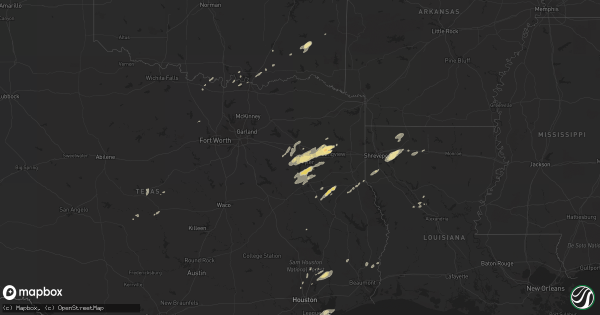
Hail Map in Texas on November 8, 2011
Get this storm
November 8 map
$229
one time, instant access
Download today. No call, no setup
Keep the $229
Bought the map and want the full workflow? Apply the entire $229 to a subscription within 7 days. None of it is wasted.
Every map, not just this one
This buys you this map. Subscription and you get every map we run, in the markets you choose from a few cities to whole states to nationwide. Plus real-time alerts the moment a storm fires.
Contact data
Name, contact info, occupancy, even credit band for addresses in the footprint. You go from where it hit to who to call.
Become the source they trust
Unlimited branding weather history reports on demand. You already have the documented answer ready for the property owner, and you are the one who showed up with it.
Property data and RoofTrace estimates
Pull up any address you have got, its value and the exact code rules for that jurisdiction, straight from One Click Code. Then RoofTrace estimates the squares, pitch, and roof value, priced the way you price.
Storm reports in Texas
Texas
| Date | Description |
|---|---|
| 11/08/20114:50 PM CST | Possible tornado on highway 105 east of moss hill. 600 power outages reported. |
| 11/08/20114:45 PM CST | Joaquin fd spotted a tornado on the ground...headed northeast toward longstreet. |
| 11/08/20113:34 PM CST | A tornado touched down 3 miles west of mount enterprise and continued on to the northeast...knocking down trees...ripping off large limbs of trees...and tearing the top |
| 11/08/20113:02 PM CST | Trees...power lines...and fencing down in crosby. Possible tornado. |
| 11/08/20112:23 PM CST | Trees down on hwy 84. |
| 11/08/20112:02 PM CST | A tornado touched down 5 miles southwest of mount enterprise in nacogdoches county...just east of happy valley. It continued on an east-northeast path crossing into rus |
| 11/08/20111:47 PM CST | Tornado on ground 7 miles north of douglass off of fm 225. Moving ne at 40 mph. |
| 11/08/20111:37 PM CST | Trees down in kingwood including at two schools. Power outages. Kingwood village one area of damage. |
| 11/08/20111:37 PM CST | Trees down in kingwood including at two schools. Power outages. Possible tornado. |
| 11/07/20117:58 PM CST | A tornado touched down near call...damaging some tin on a barn behind the convenience store...before snapping dozens of pine trees on highway 82 near the highway 1004 i |
| 11/07/20116:05 PM CST | Nine empty trailers were blown over in an industrial lot off of highway 146. |
Cities Impacted by Hail Map on November 8, 2011
- Dickinson, TX
- Minden, LA
- Sibley, LA
- Elm Grove, LA
- Haughton, LA
- Doyline, LA
- Gilmer, TX
- Gladewater, TX
- Longview, TX
- White Oak, TX
- Tyler, TX
- Ben Wheeler, TX
- Chandler, TX
- Lindale, TX
- Winona, TX
- Big Sandy, TX
- Jacksonville, TX
- Shongaloo, LA
- Haynesville, LA
- Bullard, TX
- Whitehouse, TX
- Flint, TX
- Frankston, TX
- Cushing, TX
- Sadler, TX
- Pottsboro, TX
- Dayton, TX
- Cleveland, TX
- Diana, TX
- Gloster, LA
- Grand Cane, LA
- Frierson, LA
- Keatchie, LA
- Goldthwaite, TX
- Buna, TX
- Durant, OK
- Bokchito, OK
- Richland Springs, TX
- Burneyville, OK
- Leon, OK
- Grand Saline, TX
- Mineola, TX
- Van, TX
- Gibsland, LA
- Nacogdoches, TX
- Douglass, TX
- Mount Enterprise, TX
- Conroe, TX
- Alto, TX
- Madill, OK
- Kingston, OK
- Brownsboro, TX
- Call, TX
- Atoka, OK
- Bennington, OK
- Gustine, TX
- Kingwood, TX
- Canton, TX
- New Caney, TX
- Huffman, TX
- Liberty, TX
- Colfax, LA
- Lovelady, TX
- Santa Fe, TX
- Alvin, TX
- Kountze, TX
- Warren, TX
- Hawkins, TX
- Snow, OK
- Nashoba, OK
- Troup, TX
- Cloutierville, LA
- Gordonville, TX
- Whitesboro, TX
- Saint Jo, TX
- Wilburn, AR
- Rattan, OK
- Denison, TX
- Joaquin, TX
- Arcadia, LA
- Simsboro, LA
- Tenaha, TX
- Timpson, TX
- Center, TX
- Nocona, TX
- Overton, TX
- Kilgore, TX
- Rusk, TX
- Laneville, TX
- Reklaw, TX
- Rochelle, TX
- Pangburn, AR
- Murchison, TX
- Calera, OK
- Talihina, OK
- Moyers, OK
- Antlers, OK
- Ruston, LA
- Heber Springs, AR
- Splendora, TX
- Paradise, TX
- Dubberly, LA
- Heflin, LA
- Bossier City, LA
- Spring, TX
- Houston, TX
- Palestine, TX
- Arp, TX
- Larue, TX
- League City, TX
- Anahuac, TX
- Bacliff, TX
- Atlanta, LA
- Zephyr, TX
- Early, TX
- Blanket, TX
- Comanche, TX
- Lena, LA
- Homer, LA
- Cotton Valley, LA


