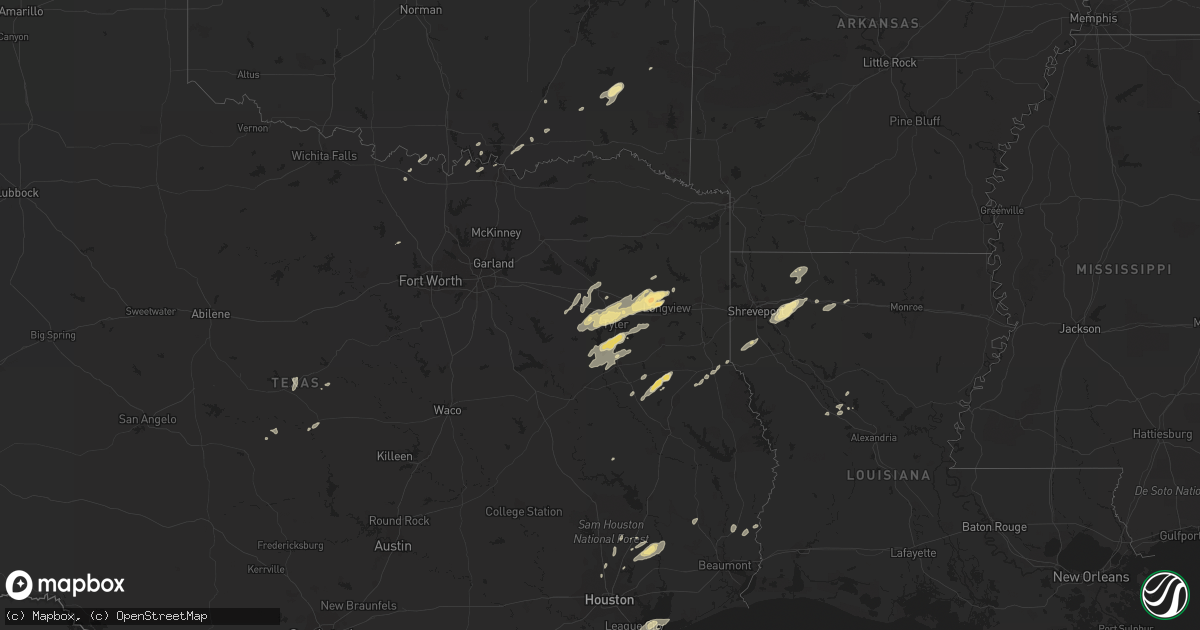
Hail Map in Oklahoma on November 8, 2011
Get this storm
November 8 map
$229
one time, instant access
Download today. No call, no setup
Keep the $229
Bought the map and want the full workflow? Apply the entire $229 to a subscription within 7 days. None of it is wasted.
Every map, not just this one
This buys you this map. Subscription and you get every map we run, in the markets you choose from a few cities to whole states to nationwide. Plus real-time alerts the moment a storm fires.
Contact data
Name, contact info, occupancy, even credit band for addresses in the footprint. You go from where it hit to who to call.
Become the source they trust
Unlimited branding weather history reports on demand. You already have the documented answer ready for the property owner, and you are the one who showed up with it.
Property data and RoofTrace estimates
Pull up any address you have got, its value and the exact code rules for that jurisdiction, straight from One Click Code. Then RoofTrace estimates the squares, pitch, and roof value, priced the way you price.
Storm reports in Oklahoma
Oklahoma
| Date | Description |
|---|---|
| 11/08/20112:27 PM CST | Railroad cars overturned on east side of town. |
| 11/08/20111:45 PM CST | An ef1 tornado touched down along n4440 where it snapped several trees. It continued ne across rural areas lifting a small outbuilding off of its base on d4447 and snap |
| 11/08/201110:15 AM CST | Roof off one downtown business...numerous trees down...one barn destroyed. |
| 11/08/20119:45 AM CST | House heavily damaged |
| 11/08/20117:40 AM CST | A local report indicates 77 MPH wind near 6 N TISHOMINGO |
| 11/08/20117:25 AM CST | Numerous trees down with some structural damage reported. Time estimated from radar. |
| 11/08/20117:15 AM CST | A local report indicates 61 MPH wind near 5 NNW LEBANON |
Cities Impacted by Hail Map on November 8, 2011
- Dickinson, TX
- Minden, LA
- Sibley, LA
- Elm Grove, LA
- Haughton, LA
- Doyline, LA
- Gilmer, TX
- Gladewater, TX
- Longview, TX
- White Oak, TX
- Tyler, TX
- Ben Wheeler, TX
- Chandler, TX
- Lindale, TX
- Winona, TX
- Big Sandy, TX
- Jacksonville, TX
- Shongaloo, LA
- Haynesville, LA
- Bullard, TX
- Whitehouse, TX
- Flint, TX
- Frankston, TX
- Cushing, TX
- Sadler, TX
- Pottsboro, TX
- Dayton, TX
- Cleveland, TX
- Diana, TX
- Gloster, LA
- Grand Cane, LA
- Frierson, LA
- Keatchie, LA
- Goldthwaite, TX
- Buna, TX
- Durant, OK
- Bokchito, OK
- Richland Springs, TX
- Burneyville, OK
- Leon, OK
- Grand Saline, TX
- Mineola, TX
- Van, TX
- Gibsland, LA
- Nacogdoches, TX
- Douglass, TX
- Mount Enterprise, TX
- Conroe, TX
- Alto, TX
- Madill, OK
- Kingston, OK
- Brownsboro, TX
- Call, TX
- Atoka, OK
- Bennington, OK
- Gustine, TX
- Kingwood, TX
- Canton, TX
- New Caney, TX
- Huffman, TX
- Liberty, TX
- Colfax, LA
- Lovelady, TX
- Santa Fe, TX
- Alvin, TX
- Kountze, TX
- Warren, TX
- Hawkins, TX
- Snow, OK
- Nashoba, OK
- Troup, TX
- Cloutierville, LA
- Gordonville, TX
- Whitesboro, TX
- Saint Jo, TX
- Wilburn, AR
- Rattan, OK
- Denison, TX
- Joaquin, TX
- Arcadia, LA
- Simsboro, LA
- Tenaha, TX
- Timpson, TX
- Center, TX
- Nocona, TX
- Overton, TX
- Kilgore, TX
- Rusk, TX
- Laneville, TX
- Reklaw, TX
- Rochelle, TX
- Pangburn, AR
- Murchison, TX
- Calera, OK
- Talihina, OK
- Moyers, OK
- Antlers, OK
- Ruston, LA
- Heber Springs, AR
- Splendora, TX
- Paradise, TX
- Dubberly, LA
- Heflin, LA
- Bossier City, LA
- Spring, TX
- Houston, TX
- Palestine, TX
- Arp, TX
- Larue, TX
- League City, TX
- Anahuac, TX
- Bacliff, TX
- Atlanta, LA
- Zephyr, TX
- Early, TX
- Blanket, TX
- Comanche, TX
- Lena, LA
- Homer, LA
- Cotton Valley, LA


