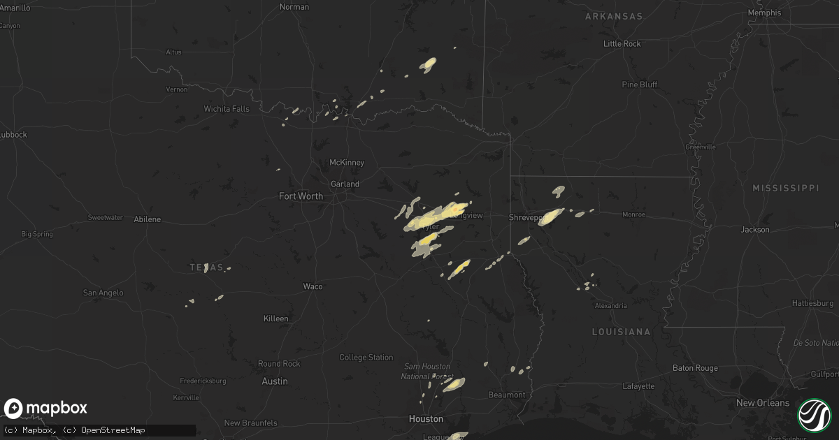
Hail Map in Louisiana on November 8, 2011
Get this storm
November 8 map
$229
one time, instant access
Download today. No call, no setup
Keep the $229
Bought the map and want the full workflow? Apply the entire $229 to a subscription within 7 days. None of it is wasted.
Every map, not just this one
This buys you this map. Subscription and you get every map we run, in the markets you choose from a few cities to whole states to nationwide. Plus real-time alerts the moment a storm fires.
Contact data
Name, contact info, occupancy, even credit band for addresses in the footprint. You go from where it hit to who to call.
Become the source they trust
Unlimited branding weather history reports on demand. You already have the documented answer ready for the property owner, and you are the one who showed up with it.
Property data and RoofTrace estimates
Pull up any address you have got, its value and the exact code rules for that jurisdiction, straight from One Click Code. Then RoofTrace estimates the squares, pitch, and roof value, priced the way you price.
Storm reports in Louisiana
Louisiana
| Date | Description |
|---|---|
| 11/08/20115:50 PM CST | An ef0 tornado touched down along hwy 1 n of ellerby rd...where a few trees were snapped. A spotter also filmed the tornado as it crossed the red river and approached t |
| 11/08/20115:37 PM CST | An ef1 tornado touched down in sabine parish east of florien on hwy 118 and moved northeast through the kisatchie national forest. Numerous trees were snapped and uproo |
| 11/08/20115:32 PM CST | Power lines down |
| 11/08/20115:28 PM CST | Tornado reported on the ground by amateur radio...near kickapoo or between kingston and frierson. |
| 11/08/20115:20 PM CST | Desoto fd reports trees down near four forks. |
| 11/08/20115:00 PM CST | Wide swath of downed trees near smyrna road and highway 5. |
| 11/08/20114:53 PM CST | An ef2 tornado touched down snapping numerous trees and heavily damaging a home along funston rd. Several trees were also uprooted and a mobile home was damaged. The to |
| 11/07/20118:40 PM CST | Tornado damage reported to home and garage reported missing in rural area...on bridges road...very close to natchitoches parish line. Sheriff enroute. |
| 11/07/20117:40 PM CST | Trees down on hwy 507 just south of simsboro. |
| 11/07/20117:40 PM CST | Trees down on la 2 se of bernice |
| 11/07/20116:49 PM CST | Tree debris noted along interstate 20...between mile markers 56 and 57. |
| 11/07/20116:29 PM CST | An ef0 tornado touched down just w of the intersection of coussons rd and hwy 531 and moved ne...snapping and uprooting several trees. The tornado crossed magnolia rd a |
| 11/07/20116:20 PM CST | An ef0 tornado touched down along hwy 7 and snapped a few trees as it headed ne. The tornado crossed mason fells road and hwy 531 where several trees were snapped. The |
Cities Impacted by Hail Map on November 8, 2011
- Dickinson, TX
- Minden, LA
- Sibley, LA
- Elm Grove, LA
- Haughton, LA
- Doyline, LA
- Gilmer, TX
- Gladewater, TX
- Longview, TX
- White Oak, TX
- Tyler, TX
- Ben Wheeler, TX
- Chandler, TX
- Lindale, TX
- Winona, TX
- Big Sandy, TX
- Jacksonville, TX
- Shongaloo, LA
- Haynesville, LA
- Bullard, TX
- Whitehouse, TX
- Flint, TX
- Frankston, TX
- Cushing, TX
- Sadler, TX
- Pottsboro, TX
- Dayton, TX
- Cleveland, TX
- Diana, TX
- Gloster, LA
- Grand Cane, LA
- Frierson, LA
- Keatchie, LA
- Goldthwaite, TX
- Buna, TX
- Durant, OK
- Bokchito, OK
- Richland Springs, TX
- Burneyville, OK
- Leon, OK
- Grand Saline, TX
- Mineola, TX
- Van, TX
- Gibsland, LA
- Nacogdoches, TX
- Douglass, TX
- Mount Enterprise, TX
- Conroe, TX
- Alto, TX
- Madill, OK
- Kingston, OK
- Brownsboro, TX
- Call, TX
- Atoka, OK
- Bennington, OK
- Gustine, TX
- Kingwood, TX
- Canton, TX
- New Caney, TX
- Huffman, TX
- Liberty, TX
- Colfax, LA
- Lovelady, TX
- Santa Fe, TX
- Alvin, TX
- Kountze, TX
- Warren, TX
- Hawkins, TX
- Snow, OK
- Nashoba, OK
- Troup, TX
- Cloutierville, LA
- Gordonville, TX
- Whitesboro, TX
- Saint Jo, TX
- Wilburn, AR
- Rattan, OK
- Denison, TX
- Joaquin, TX
- Arcadia, LA
- Simsboro, LA
- Tenaha, TX
- Timpson, TX
- Center, TX
- Nocona, TX
- Overton, TX
- Kilgore, TX
- Rusk, TX
- Laneville, TX
- Reklaw, TX
- Rochelle, TX
- Pangburn, AR
- Murchison, TX
- Calera, OK
- Talihina, OK
- Moyers, OK
- Antlers, OK
- Ruston, LA
- Heber Springs, AR
- Splendora, TX
- Paradise, TX
- Dubberly, LA
- Heflin, LA
- Bossier City, LA
- Spring, TX
- Houston, TX
- Palestine, TX
- Arp, TX
- Larue, TX
- League City, TX
- Anahuac, TX
- Bacliff, TX
- Atlanta, LA
- Zephyr, TX
- Early, TX
- Blanket, TX
- Comanche, TX
- Lena, LA
- Homer, LA
- Cotton Valley, LA


