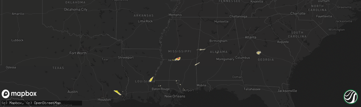
Hail Map in Mississippi on November 7, 2018
The weather event in Mississippi on November 7, 2018 includes Hail map. 5 states and 43 cities were impacted and suffered possible damage. The total estimated number of properties impacted is 5,908.
Want more than just the map?
Turn this storm into a full workflow.
- Owner + property data so you know who to knock
- OnDemand branded weather history reports to win the "did we even have hail?" argument
- RoofTrace estimate so reps stop guessing numbers at the door
Bought this map? Upgrade within 7 days and we'll credit the $230. (10-15 min setup call)
Hail
5,908
Estimated number of impacted properties by a 1.00" hail or larger801
Estimated number of impacted properties by a 1.75" hail or larger0
Estimated number of impacted properties by a 2.50" hail or largerStorm reports in Mississippi
Mississippi
| Date | Description |
|---|---|
| 11/07/20188:36 AM CST | Golfball size hail along jc prestage rd. Reported by leesburg water association. |
| 11/07/20188:33 AM CST | Hail slightly larger than golfball size near the intersection of harrell rd and rehobeth rd. |
| 11/07/20184:32 AM CST | Mostly dime to nickel size hail with a few stones around quarter size mixed in. Fell near the intersection of monument and gallatin streets. |
| 11/07/20182:23 AM CST | At 823 AM CST, a severe thunderstorm was located near Pelahatchie, or 10 miles west of Morton, moving northeast at 35 mph. HAZARD...Half dollar size hail. SOURCE...Radar indicated. IMPACT...Damage to vehicles is expected. This severe thunderstorm will be near... Leesburg around 835 AM CST. Branch around 840 AM CST. Forkville around 845 AM CST. Harperville and Hillsboro around 900 AM CST. Steele around 910 AM CST.Other locations impacted by this severe thunderstorm includeSebastopol. |
| 11/06/20189:22 PM CST | At 322 PM CST, a severe thunderstorm was located over Diamondhead, moving east at 20 mph. HAZARD...60 mph wind gusts and half dollar size hail. SOURCE...Radar indicated. IMPACT...Hail damage to vehicles is expected. Expect wind damage to roofs, siding, and trees. Locations impacted include... Gulfport, Long Beach, Bay St. Louis, Waveland, Diamondhead, Kiln, Lyman, Shoreline Park, Saucier and Gulfport Airport. |
All States Impacted by Hail Map on November 7, 2018
Cities Impacted by Hail Map on November 7, 2018
- Angie, LA
- Franklinton, LA
- Beaumont, TX
- Kountze, TX
- Saratoga, TX
- Sour Lake, TX
- Marksville, LA
- Simmesport, LA
- Plaucheville, LA
- Moreauville, LA
- Lumberton, TX
- Port Neches, TX
- Nederland, TX
- Zachary, LA
- Pelahatchie, MS
- Flowood, MS
- Brandon, MS
- Morton, MS
- Pearl, MS
- Maplesville, AL
- Stanton, AL
- Macon, GA
- Lizella, GA
- Quitman, MS
- Carriere, MS
- Poplarville, MS
- Knoxville, GA
- Fort Valley, GA
- Byron, GA
- Musella, GA
- Opelousas, LA
- Buna, TX
- Houston, TX
- Diamondhead, MS
- Macon, MS
- Eutaw, AL
- Knoxville, AL
- Aliceville, AL
- Bogalusa, LA
- Butler, AL
- Needham, AL
- Kiln, MS
- Jackson, MS


