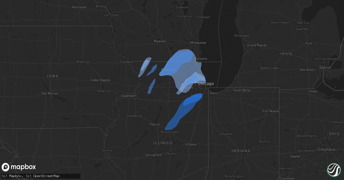
Hail Map in Wisconsin on November 5, 2022
Get this storm
November 5 map
$229
one time, instant access
Download today. No call, no setup
Keep the $229
Bought the map and want the full workflow? Apply the entire $229 to a subscription within 7 days. None of it is wasted.
Every map, not just this one
This buys you this map. Subscription and you get every map we run, in the markets you choose from a few cities to whole states to nationwide. Plus real-time alerts the moment a storm fires.
Contact data
Name, contact info, occupancy, even credit band for addresses in the footprint. You go from where it hit to who to call.
Become the source they trust
Unlimited branding weather history reports on demand. You already have the documented answer ready for the property owner, and you are the one who showed up with it.
Property data and RoofTrace estimates
Pull up any address you have got, its value and the exact code rules for that jurisdiction, straight from One Click Code. Then RoofTrace estimates the squares, pitch, and roof value, priced the way you price.
Storm reports in Wisconsin
Wisconsin
| Date | Description |
|---|---|
| 11/05/202212:42 PM CDT | Corrects previous tstm wnd dmg report from 2 s saukville for time. Scattered damage reports of downed trees and power lines throughout the county. Time est. From radar. |
| 11/05/202212:38 PM CDT | Corrects previous tstm wnd dmg report from 2 e west bend for time. Scattered damage reports of trees and power lines down throughout the county. |
| 11/05/202212:37 PM CDT | Corrects previous tstm wnd dmg report from 1 ssw whitefish bay for time. Trees down in estabrook park. Time est from radar. |
| 11/05/202212:37 PM CDT | Pic from social media showing several power poles snapped near cedarburg. Time est from radar. |
| 11/05/202212:32 PM CDT | Associated with fropa. |
| 11/05/202212:23 PM CDT | Corrects previous tstm wnd dmg report from west allis for time. Power outages reported in west allis. |
| 11/05/202212:23 PM CDT | Social media report from home weather station. |
| 11/05/202212:22 PM CDT | Pic from social media showing a flag pole bent at a 45 degree angle. Time est from radar. |
| 11/05/202212:17 PM CDT | Corrects previous tstm wnd dmg report from 3 n new berlin for time. Scattered damage reports of trees and wires down throughout the county. Power outages reported in br |
| 11/05/202212:07 PM CDT | Corrects previous tstm wnd dmg report from 1 ssw paddock lake for time. Scattered damage reports of trees and power lines down across the county from salem lakes east t |
| 11/05/202212:00 PM CDT | Corrects previous tstm wnd dmg report from burlington for time. Scattered damage reports of trees and power lines down throughout the county from burlington east to lak |
| 11/05/202211:42 AM CDT | Scattered damage reports of downed trees and power lines throughout the county. Time est. From radar. |
| 11/05/202211:38 AM CDT | Scattered damage reports of trees and power lines down throughout the county. |
| 11/05/202211:38 AM CDT | Tree down and fell on top of a vehicle. |
| 11/05/202211:37 AM CDT | Trees down in estabrook park. Time est from radar. |
| 11/05/202211:31 AM CDT | At least one tree down in town. |
| 11/05/202211:23 AM CDT | Power outages reported in west allis. |
| 11/05/202211:17 AM CDT | Scattered damage reports of trees and wires down throughout the county. Power outages reported in brookfield... New berlin and vernon. Time est from radar. |
| 11/05/202211:07 AM CDT | Scattered damage reports of trees and power lines down across the county from salem lakes east to lake michigan. Time est from radar. |
| 11/05/202211:00 AM CDT | Scattered damage reports of trees and power lines down throughout the county from burlington east to lake michigan. Time est from radar. |
| 11/05/202210:37 AM CDT | Power pole down in town with 2 trees down outside of town in new glarus township. Time est from radar. |
| 11/05/20227:37 AM CDT | At 1236 PM CDT, severe thunderstorms were located along a line extending from Kewaskum to near Germantown, moving northeast at 45 mph. HAZARD...60 mph wind gusts. SOURCE...Radar indicated. IMPACT...Expect damage to roofs, siding, and trees. Locations impacted include... West Bend, Mequon, Brown Deer, Grafton, Cedarburg, Port Washington, Jackson, Saukville, Bayside, Kewaskum, Thiensville, Germantown, Oostburg, Belgium, Fredonia, Cedar Grove, Random Lake, Newburg, Adell and Beechwood. |
| 11/05/20225:39 AM CDT | At 1039 AM CDT, severe thunderstorms were located along a line extending from near Lake Summerset to near Winnebago to Rockford Airport, moving northeast at 40 mph. HAZARD...60 mph wind gusts. SOURCE...Radar indicated. IMPACT...Expect damage to roofs, siding, and trees. Locations impacted include... Rockford, Belvidere, Loves Park, Machesney Park, Roscoe, South Beloit, Rockton, Poplar Grove, Rockford Airport, Candlewick Lake, Cherry Valley, Winnebago, Davis Junction, Durand, Capron, Timberlane, New Milford, Garden Prairie, Caledonia and Shirland.Including the following interstates... I-39 between mile markers 115 and 123. I-90 between mile markers 1 and 31.This includes... Boone County Fairgrounds, Rock Cut State Park, RockValley College, Rockford Aviators Baseball, and Rockford Speedway. |
| 11/05/20224:53 AM CDT | At 953 AM CDT, severe thunderstorms were located along a line extending from near Apple River to near Hitt, moving northeast at 45 mph. HAZARD...60 mph wind gusts. SOURCE...Radar indicated. IMPACT...Expect damage to roofs, siding, and trees. Locations impacted include... German Valley. |
| 11/05/20224:30 AM CDT | At 929 AM CDT, severe thunderstorms were located along a line extending from Council Hill to near Elizabeth to near Hanover, moving northeast at 55 mph. HAZARD...60 mph wind gusts. SOURCE...Radar indicated. IMPACT...Expect damage to roofs, siding, and trees. Locations impacted include... Darlington, Shullsburg, Belmont, Benton, Argyle, Blanchardville, Wiota, New Diggings, South Wayne, Elk Grove, Fayette, Lamont, Gratiot, Platte Mounds, Calamine, Lead Mine, Yellowstone Lake St Park and Woodford. |
| 11/05/20224:27 AM CDT | At 927 AM CDT, severe thunderstorms were located along a line extending from Guilford to near Mississippi Palisades State Park to near Fenton, moving northeast at 50 mph. HAZARD...60 mph wind gusts. SOURCE...Radar indicated. IMPACT...Expect damage to roofs, siding, and trees. Severe thunderstorms will be near... Schapville, Guilford, Mississippi Palisades State Park, Galena Territory and Rodden around 930 AM CDT. Scales Mound, Apple Canyon Lake, Camp Far Horizons and Agnew around 935 AM CDT. Elizabeth, Apple River, Massbach, White Pigeon, Franklin Corners and Elizabeth Fairgrounds around 940 AM CDT. Fairhaven, Woodbine, Coleta, Elmoville, Willow and Ideal around 945 AM CDT.Other locations in the path of these severe thunderstorms includeStockton, Milledgeville, Chadwick, Kent, Stockton Airport, CarrollCounty Fairgrounds, Canyon Camp, Hitt, Apple River Canyon State Park,Lanark, Warren, Nora, Jo Daviess County Fairgrounds, Waddams Grove,Lake Le-Aqua-na State Park and Shannon. |
Cities Impacted by Hail Map on November 5, 2022
- South Wayne, WI
- Mount Carroll, IL
- Stockton, IL
- Lena, IL
- Gratiot, WI
- Savanna, IL
- Winslow, IL
- Pearl City, IL
- Browntown, WI
- Kent, IL
- Elizabeth, IL
- Sabula, IA
- Monroe, WI
- Nora, IL
- Warren, IL
- Bloomingdale, IL
- Elgin, IL
- Elburn, IL
- Rolling Meadows, IL
- Itasca, IL
- Saint Charles, IL
- Schaumburg, IL
- Hoffman Estates, IL
- Palatine, IL
- Geneva, IL
- Bartlett, IL
- Streamwood, IL
- Arlington Heights, IL
- Carol Stream, IL
- Elk Grove Village, IL
- West Chicago, IL
- Wayne, IL
- Hanover Park, IL
- Batavia, IL
- Roselle, IL
- Medinah, IL
- South Wilmington, IL
- Braidwood, IL
- Wilmington, IL
- Homer Glen, IL
- New Lenox, IL
- Morris, IL
- Lockport, IL
- Towanda, IL
- Mazon, IL
- Lexington, IL
- Odell, IL
- Seneca, IL
- Danvers, IL
- Normal, IL
- Manhattan, IL
- Carlock, IL
- Frankfort, IL
- Channahon, IL
- Monee, IL
- Minooka, IL
- Verona, IL
- Matteson, IL
- Streator, IL
- Secor, IL
- Shorewood, IL
- Tinley Park, IL
- Mokena, IL
- Joliet, IL
- Bloomington, IL
- Chenoa, IL
- El Paso, IL
- Cornell, IL
- Cabery, IL
- Gardner, IL
- Ransom, IL
- Dwight, IL
- Elwood, IL
- Reddick, IL
- Pontiac, IL
- Gridley, IL
- Flanagan, IL
- Coal City, IL
- Kinsman, IL
- Emington, IL
- Essex, IL
- Crest Hill, IL
- Braceville, IL
- Orland Park, IL
- Blackstone, IL
- Graymont, IL
- Hudson, IL
- Bonfield, IL
- Prophetstown, IL
- Rock Falls, IL
- Tampico, IL
- Dixon, IL
- Polo, IL
- Sterling, IL
- Deer Grove, IL
- Lanark, IL
- Freeport, IL
- Dakota, IL
- Baileyville, IL
- Rock City, IL
- Shannon, IL
- Ridott, IL
- Leland, IL
- Glendale Heights, IL
- Glenview, IL
- Skokie, IL
- Schiller Park, IL
- Des Plaines, IL
- Addison, IL
- Sugar Grove, IL
- Plano, IL
- Harwood Heights, IL
- Somonauk, IL
- Newark, IL
- Wasco, IL
- Sandwich, IL
- Lombard, IL
- Mooseheart, IL
- Mount Prospect, IL
- Winnetka, IL
- Niles, IL
- Wilmette, IL
- North Aurora, IL
- Wheeling, IL
- Aurora, IL
- Villa Park, IL
- Franklin Park, IL
- South Elgin, IL
- Evanston, IL
- Lincolnwood, IL
- Wood Dale, IL
- Lake Zurich, IL
- Morton Grove, IL
- Sheridan, IL
- Chicago, IL
- Prospect Heights, IL
- Bristol, IL
- Lincolnshire, IL
- Bensenville, IL
- Northbrook, IL
- Golf, IL
- Elmhurst, IL
- Maple Park, IL
- Warrenville, IL
- Glen Ellyn, IL
- Park Ridge, IL
- Barrington, IL
- Buffalo Grove, IL
- Big Rock, IL
- Hinckley, IL
- Wheaton, IL
- Winfield, IL
- Whitewater, WI
- Walworth, WI
- Stillman Valley, IL
- Hebron, IL
- Richmond, IL
- Twin Lakes, WI
- Williams Bay, WI
- Monroe Center, IL
- Genoa City, WI
- Byron, IL
- Belvidere, IL
- Cherry Valley, IL
- Delavan, WI
- Springfield, WI
- Kansasville, WI
- Marengo, IL
- Harvard, IL
- Loves Park, IL
- Roscoe, IL
- Machesney Park, IL
- Oregon, IL
- Elkhorn, WI
- Lake Geneva, WI
- Capron, IL
- Sharon, WI
- Rochester, WI
- Rockford, IL
- Waterford, WI
- Darien, WI
- Garden Prairie, IL
- Caledonia, IL
- Fontana, WI
- East Troy, WI
- Rockton, IL
- Silver Lake, WI
- Leaf River, IL
- Janesville, WI
- Beloit, WI
- Poplar Grove, IL
- Kirkland, IL
- South Beloit, IL
- Avalon, WI
- Burlington, WI
- Kingston, IL
- Davis Junction, IL
- Union Grove, WI
- Clinton, WI
- Salem, WI
- Winnebago, IL
- Pecatonica, IL


