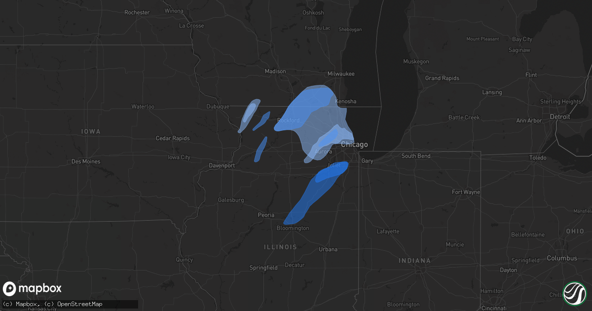
Hail Map in Iowa on November 5, 2022
Get this storm
November 5 map
$229
one time, instant access
Download today. No call, no setup
Keep the $229
Bought the map and want the full workflow? Apply the entire $229 to a subscription within 7 days. None of it is wasted.
Every map, not just this one
This buys you this map. Subscription and you get every map we run, in the markets you choose from a few cities to whole states to nationwide. Plus real-time alerts the moment a storm fires.
Contact data
Name, contact info, occupancy, even credit band for addresses in the footprint. You go from where it hit to who to call.
Become the source they trust
Unlimited branding weather history reports on demand. You already have the documented answer ready for the property owner, and you are the one who showed up with it.
Property data and RoofTrace estimates
Pull up any address you have got, its value and the exact code rules for that jurisdiction, straight from One Click Code. Then RoofTrace estimates the squares, pitch, and roof value, priced the way you price.
Storm reports in Iowa
Iowa
| Date | Description |
|---|---|
| 11/05/20228:19 AM CDT | Tree down on street near residence... Time estimated from radar. |
| 11/05/20227:55 AM CDT | Awos station kmut muscatine arpt. |
| 11/05/20223:01 AM CDT | At 800 AM CDT, severe thunderstorms were located along a line extending from Rochester to Wilton to Millersburg, moving northeast at 50 mph. HAZARD...60 mph wind gusts. SOURCE...Radar indicated. At 755 AM a 59 MPH gust was measured at the Muscatine Airport. IMPACT...Expect damage to roofs, siding, and trees. Severe thunderstorms will be near... Durant, Wilton, Rochester, Stockton, Cedar Valley Park and Cedar Valley around 805 AM CDT. Tipton, Sunbury, Tipton Matthews Airport and Cedar County Fairgrounds around 810 AM CDT. Bennett, Taylor Ridge, New Liberty, Bennett Park, Camp Liberty, Plainview and Loud Thunder Scout Camp around 815 AM CDT. Stanwood, Milan, Andalusia, Oak Grove, Clarence, Dixon, Big Rock, Sherman Park, Coyne Center and Buffalo Shores around 820 AM CDT.Other locations in the path of these severe thunderstorms includeBuffalo, Lowden, Wheatland, Calamus, Credit Island, Blackhawk StatePark, West Lake Park, Fruitland, Indian Bluff Golf Course, MolineQuad-City Airport, Davenport, Moline, Rock Island, Mississippi ValleyFairgrounds, Rock Island Arsenal and Davenport Municipal Airport. |
Cities Impacted by Hail Map on November 5, 2022
- South Wayne, WI
- Mount Carroll, IL
- Stockton, IL
- Lena, IL
- Gratiot, WI
- Savanna, IL
- Winslow, IL
- Pearl City, IL
- Browntown, WI
- Kent, IL
- Elizabeth, IL
- Sabula, IA
- Monroe, WI
- Nora, IL
- Warren, IL
- Bloomingdale, IL
- Elgin, IL
- Elburn, IL
- Rolling Meadows, IL
- Itasca, IL
- Saint Charles, IL
- Schaumburg, IL
- Hoffman Estates, IL
- Palatine, IL
- Geneva, IL
- Bartlett, IL
- Streamwood, IL
- Arlington Heights, IL
- Carol Stream, IL
- Elk Grove Village, IL
- West Chicago, IL
- Wayne, IL
- Hanover Park, IL
- Batavia, IL
- Roselle, IL
- Medinah, IL
- South Wilmington, IL
- Braidwood, IL
- Wilmington, IL
- Homer Glen, IL
- New Lenox, IL
- Morris, IL
- Lockport, IL
- Towanda, IL
- Mazon, IL
- Lexington, IL
- Odell, IL
- Seneca, IL
- Danvers, IL
- Normal, IL
- Manhattan, IL
- Carlock, IL
- Frankfort, IL
- Channahon, IL
- Monee, IL
- Minooka, IL
- Verona, IL
- Matteson, IL
- Streator, IL
- Secor, IL
- Shorewood, IL
- Tinley Park, IL
- Mokena, IL
- Joliet, IL
- Bloomington, IL
- Chenoa, IL
- El Paso, IL
- Cornell, IL
- Cabery, IL
- Gardner, IL
- Ransom, IL
- Dwight, IL
- Elwood, IL
- Reddick, IL
- Pontiac, IL
- Gridley, IL
- Flanagan, IL
- Coal City, IL
- Kinsman, IL
- Emington, IL
- Essex, IL
- Crest Hill, IL
- Braceville, IL
- Orland Park, IL
- Blackstone, IL
- Graymont, IL
- Hudson, IL
- Bonfield, IL
- Prophetstown, IL
- Rock Falls, IL
- Tampico, IL
- Dixon, IL
- Polo, IL
- Sterling, IL
- Deer Grove, IL
- Lanark, IL
- Freeport, IL
- Dakota, IL
- Baileyville, IL
- Rock City, IL
- Shannon, IL
- Ridott, IL
- Leland, IL
- Glendale Heights, IL
- Glenview, IL
- Skokie, IL
- Schiller Park, IL
- Des Plaines, IL
- Addison, IL
- Sugar Grove, IL
- Plano, IL
- Harwood Heights, IL
- Somonauk, IL
- Newark, IL
- Wasco, IL
- Sandwich, IL
- Lombard, IL
- Mooseheart, IL
- Mount Prospect, IL
- Winnetka, IL
- Niles, IL
- Wilmette, IL
- North Aurora, IL
- Wheeling, IL
- Aurora, IL
- Villa Park, IL
- Franklin Park, IL
- South Elgin, IL
- Evanston, IL
- Lincolnwood, IL
- Wood Dale, IL
- Lake Zurich, IL
- Morton Grove, IL
- Sheridan, IL
- Chicago, IL
- Prospect Heights, IL
- Bristol, IL
- Lincolnshire, IL
- Bensenville, IL
- Northbrook, IL
- Golf, IL
- Elmhurst, IL
- Maple Park, IL
- Warrenville, IL
- Glen Ellyn, IL
- Park Ridge, IL
- Barrington, IL
- Buffalo Grove, IL
- Big Rock, IL
- Hinckley, IL
- Wheaton, IL
- Winfield, IL
- Whitewater, WI
- Walworth, WI
- Stillman Valley, IL
- Hebron, IL
- Richmond, IL
- Twin Lakes, WI
- Williams Bay, WI
- Monroe Center, IL
- Genoa City, WI
- Byron, IL
- Belvidere, IL
- Cherry Valley, IL
- Delavan, WI
- Springfield, WI
- Kansasville, WI
- Marengo, IL
- Harvard, IL
- Loves Park, IL
- Roscoe, IL
- Machesney Park, IL
- Oregon, IL
- Elkhorn, WI
- Lake Geneva, WI
- Capron, IL
- Sharon, WI
- Rochester, WI
- Rockford, IL
- Waterford, WI
- Darien, WI
- Garden Prairie, IL
- Caledonia, IL
- Fontana, WI
- East Troy, WI
- Rockton, IL
- Silver Lake, WI
- Leaf River, IL
- Janesville, WI
- Beloit, WI
- Poplar Grove, IL
- Kirkland, IL
- South Beloit, IL
- Avalon, WI
- Burlington, WI
- Kingston, IL
- Davis Junction, IL
- Union Grove, WI
- Clinton, WI
- Salem, WI
- Winnebago, IL
- Pecatonica, IL


