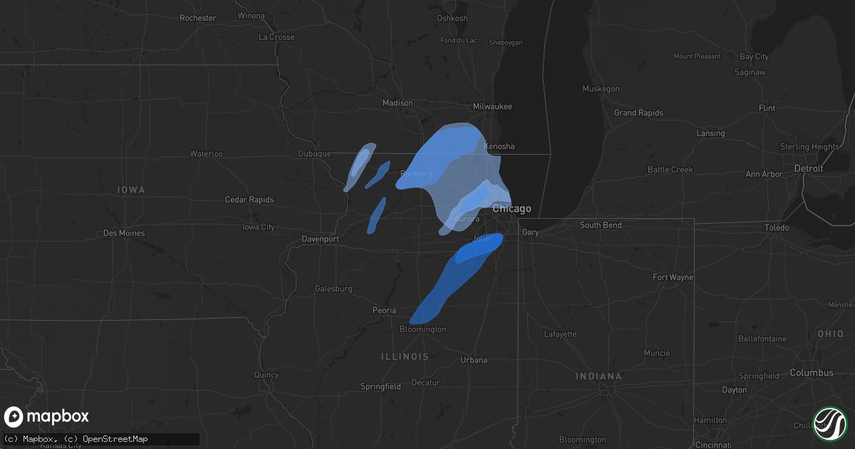
Hail Map in Illinois on November 5, 2022
Get this storm
November 5 map
$229
one time, instant access
Download today. No call, no setup
Keep the $229
Bought the map and want the full workflow? Apply the entire $229 to a subscription within 7 days. None of it is wasted.
Every map, not just this one
This buys you this map. Subscription and you get every map we run, in the markets you choose from a few cities to whole states to nationwide. Plus real-time alerts the moment a storm fires.
Contact data
Name, contact info, occupancy, even credit band for addresses in the footprint. You go from where it hit to who to call.
Become the source they trust
Unlimited branding weather history reports on demand. You already have the documented answer ready for the property owner, and you are the one who showed up with it.
Property data and RoofTrace estimates
Pull up any address you have got, its value and the exact code rules for that jurisdiction, straight from One Click Code. Then RoofTrace estimates the squares, pitch, and roof value, priced the way you price.
Storm reports in Illinois
Illinois
| Date | Description |
|---|---|
| 11/05/202212:46 PM CDT | Corrects previous tstm wnd dmg report from 1 ene manhattan. Photos of at least three telephone poles leaning towards the nne. Time of damage and location based on spott |
| 11/05/202212:46 PM CDT | Photos of at least telephone poles leaning towards the nne. Time of damage and location based on spotter information. |
| 11/05/202212:17 PM CDT | Measured wind gust of 56 kts |
| 11/05/202212:15 PM CDT | Trained spotter reports approximately 3-foot diameter tree down on the 1500 block of west wilson ave. Time estimated by radar. |
| 11/05/202212:15 PM CDT | Trained spotter reports tree down on top of two cars on the 3700 block of n clifton ave. Estimates diameter of tree to be 2 to 3 feet. Time estimated by radar. |
| 11/05/202212:15 PM CDT | Trained spotter reports several 4 to 6 inch tree branches down on the 2600 block of west wilson ave. Time estimated by radar. |
| 11/05/202212:11 PM CDT | Photo shared on social media of siding torn off a house. Location estimated but time stated in post. |
| 11/05/202211:50 AM CDT | Relayed via nws chat. |
| 11/05/202211:47 AM CDT | Report relayed via nws chat. |
| 11/05/202211:46 AM CDT | Corrects previous tstm wnd dmg report for time from 1 ene manhattan. Photos of at least three telephone poles leaning towards the nne. Time of damage and location based |
| 11/05/202211:43 AM CDT | Spotter report of a 1 foot diameter evergreen snapped and blown onto a house from the earlier squall line. Time based on radar. |
| 11/05/202211:40 AM CDT | Corrects previous non-tstm wnd dmg report from 1 n crystal lake. Mchenry county sheriff reports several felled trees and downed power lines across the county. Exact loc |
| 11/05/202211:32 AM CDT | Corrects previous tstm wnd gst report from dupage airport. Measured gust of 67 kts |
| 11/05/202211:32 AM CDT | Measured gust of 67 kts |
| 11/05/202211:17 AM CDT | Corrects previous tstm wnd dmg report to add additional information from 1 ene oglesby. La salle so reports several large trees down across ed hand highway south of sta |
| 11/05/202211:11 AM CDT | Corrects previous tstm wnd dmg report from 2 n yorkville for time. Photo shared on social media of siding torn off a house. Location estimated but time stated in post. |
| 11/05/202211:09 AM CDT | Report relayed via social media of numerous trees and powerlines downed near big rock. Time and location estimates. |
| 11/05/202210:44 AM CDT | Reports of power lines down on grand blvd in loves park. Time estimated from radar. |
| 11/05/202210:42 AM CDT | Rockford airport reported a wind gust of 51 kts |
| 11/05/202210:25 AM CDT | Gas station canopy destroyed as a line of showers moved through. Time estimated via radar. Relayed via wcia-tv. |
| 11/05/202210:20 AM CDT | A local report indicates 66 MPH wind near 2 SSE URBANA |
| 11/05/202210:20 AM CDT | A local report indicates 59 MPH wind near DECATUR AIRPORT |
| 11/05/202210:17 AM CDT | La salle so reports several large trees down across ed hand highway south of state route 71. Time estimated. |
| 11/05/202210:15 AM CDT | A local report indicates 65 MPH wind near 3 WNW TOWANDA |
| 11/05/202210:12 AM CDT | Several reports of trees and power lines down in the freeport metro area. |
| 11/05/20229:58 AM CDT | Tree reported down in town. |
| 11/05/20229:54 AM CDT | Sheriff office reports tree branch damaged power line at the 500 block of east bradshaw st in dixon. Time estimated from radar. |
| 11/05/20229:54 AM CDT | Very strong wind gust on wind sensor 24 foot off ground...many small branches down. |
| 11/05/20229:51 AM CDT | Power lines and poles down in galva... Relayed from law enforcement. Time estimated from radar. |
| 11/05/20229:50 AM CDT | Wires pulled down from a house in lanark. Time estimated from radar. |
| 11/05/20229:38 AM CDT | Apple trees reported down in town. |
| 11/05/20229:30 AM CDT | A local report indicates 58 MPH wind near 5 N TAMPICO |
| 11/05/20229:30 AM CDT | Tree down near hoover rd and yates rd in deer grove. Time estimated from radat. |
| 11/05/20229:25 AM CDT | Report of tree taking down power lines in tampico. Time estimated from radar. |
| 11/05/20229:00 AM CDT | Photos from social media show a damaged and overturned large structure. Time was estimated from radar. |
| 11/05/20228:51 AM CDT | Corrects previous tstm wnd dmg report from galva. Power lines and poles down in galva... Relayed from law enforcement. Time estimated from radar. |
| 11/05/20228:49 AM CDT | Report of tree down in rapids city per law enforcement. |
| 11/05/20228:43 AM CDT | Power lines down in colona... Time estimated from radar. |
| 11/05/20228:35 AM CDT | Tree down on rte 6 northeast of coal valley. Time estimated from radar. |
| 11/05/20226:49 AM CDT | At 1147 AM CDT, severe thunderstorms were located along a line extending from 7 miles west of Dousman to Bull Valley, moving northeast at 45 mph. HAZARD...60 mph wind gusts. SOURCE...Law enforcement reported trees down across western portions of Walworth County. IMPACT...Expect damage to roofs, siding, and trees. Locations impacted include... Milwaukee, Kenosha, Racine, Waukesha, West Allis, Wauwatosa, New Berlin, Brookfield, Greenfield, Menomonee Falls, Oak Creek, Mount Pleasant, Muskego, South Milwaukee, Pleasant Prairie, Cudahy, Whitefish Bay, Greendale, Pewaukee and Brown Deer.This includes the following Locations Boerner Botanical Gardens,General Mitchell International Airport, Timmerman Airport, Froedert &the Medical College, Fiserv Forum, Pewaukee Lake, Ottawa LakeRecreation Area, and Pinewoods Campground. |
| 11/05/20226:20 AM CDT | At 1119 AM CDT, severe thunderstorms were located along a line extending from Lake Koshkonong to 6 miles southeast of Milton to Sharon, moving northeast at 50 mph. HAZARD...60 mph wind gusts. SOURCE...Radar indicated. IMPACT...Expect damage to roofs, siding, and trees. Locations impacted include... Janesville, Whitewater, Fort Atkinson, Elkhorn, Delavan, Lake Geneva, Milton, Edgerton, East Troy, Williams Bay, Genoa City, Walworth, Clinton, Palmyra, Fontana-On-Geneva Lake, Sharon, Darien, Como, Pell Lake and Potter Lake. |
| 11/05/20226:11 AM CDT | At 1110 AM CDT, severe thunderstorms were located along a line extending from Clinton to near Belvidere to near Kingston, moving northeast at 30 mph. These storms have a history of producing wind damage across Winnebago county. HAZARD...60 mph wind gusts. SOURCE...Winnebago county sherriff. IMPACT...Expect damage to roofs, siding, and trees. Locations impacted include... Crystal Lake, Algonquin, Lake in the Hills, McHenry, Woodstock, Huntley, Fox Lake, Harvard, Island Lake, Marengo, Cary, Hampshire, Johnsburg, Lakemoor, Spring Grove, Fox River Grove, Barrington Hills, Wonder Lake, Lakewood and Pistakee Highlands.Including the following interstate... I-90 between mile markers 32 and 41. This includes... Mchenry County College, Mchenry County Fairgrounds,and Moraine Hills State Park. |
| 11/05/20225:52 AM CDT | At 1052 AM CDT, severe thunderstorms were located along a line extending from near Cherry Valley to near Waterman to near Marseilles to near Odell, moving east at 40 mph. HAZARD...60 mph wind gusts. SOURCE...Radar indicated. IMPACT...Expect damage to roofs, siding, and trees. Locations impacted include... Aurora, Joliet, Elgin, DeKalb, Bartlett, Plainfield, Carpentersville, St. Charles, Oswego, Algonquin, West Chicago, Batavia, Huntley, Geneva, Sycamore, Yorkville, Morris, Channahon, Campton Hills and Minooka.Including the following interstates... I-55 between mile markers 219 and 234. I-80 between mile markers 98 and 123. I-88 between mile markers 86 and 120. I-90 between mile markers 42 and 56.This includes... Northern Illinois University, Sandwich Fairgrounds,Aurora University, Elgin Community College, Fermilab, Gebhard WoodsState Park, Grundy County Speedway and Fairgrounds, IL Math andScience Academy, Kane County Cougars Ballpark, Waubonsee CommunityCollege, and William G Stratton State Park. |
| 11/05/20225:07 AM CDT | At 1006 AM CDT, severe thunderstorms were located along a line extending from 7 miles north of Darlington to near Warren to near Lena, moving northeast at 50 mph. HAZARD...70 mph wind gusts. SOURCE...Radar indicated. IMPACT...Expect considerable tree damage. Damage is likely to mobile homes, roofs, and outbuildings. Locations impacted include... Monroe, Brodhead, Belleville, New Glarus, Brooklyn, Monticello, Albany, Argyle, Blanchardville, Wiota, Dayton, South Wayne, Lamont, Hollandale, Browntown, Attica, Juda, Jordan Center, Yellowstone Lake St Park and Woodford.This includes the following Location York Memorial Church. |
| 11/05/20224:31 AM CDT | At 931 AM CDT, severe thunderstorms were located along a line extending from Normandy to near Sparland, moving northeast at 50 mph. HAZARD...60 mph wind gusts. SOURCE...Radar indicated. IMPACT...Expect damage to roofs, siding, and trees. Severe thunderstorms will be near... Walnut around 935 AM CDT. Lake Thunderbird around 940 AM CDT. McNabb and Magnolia around 945 AM CDT. Hennepin, Granville, Bureau Junction, Mark and Florid around 950 AM CDT.Other locations in the path of these severe thunderstorms includeDePue, Seatonville, Standard, Hollowayville, Spring Valley Airport,Ottville, Spring Valley, Ladd, Dalzell and Cherry. |
| 11/05/20224:28 AM CDT | At 925 AM CDT, severe squalls producing little to no lightning were located along a line extending from near Andover to Prophetstown to 8 miles southwest of Walnut to near Buda, moving northeast at 45 mph. HAZARD...70 mph wind gusts. SOURCE...Radar indicated. IMPACT...Expect considerable tree damage. Damage is likely to mobile homes, roofs, and outbuildings. Locations impacted include... Dixon, Peru, La Salle, Rochelle, Mendota, Byron, Oregon, Mount Morris, Amboy, Polo, Oglesby, Davis Junction, Earlville, Forreston, North Utica, Hillcrest, Stillman Valley, Franklin Grove, Ashton and Paw Paw.Including the following interstates... I-39 between mile markers 42 and 114. I-80 between mile markers 73 and 87. I-88 between mile markers 45 and 82.This includes... Buffalo Rock State Park, Castle Rock State Park,Illinois Valley Community College, Lee County Fairgrounds, LowdenState Park, Matthiessen State Park, Ogle County Fairgrounds, SaukValley College, Starved Rock State Park, Tri-County Fairgrounds, andWhite Pines State Park. |
| 11/05/20224:07 AM CDT | At 906 AM CDT, severe thunderstorms were located along a line extending from near Hillsdale to near Annawan to Osceola, moving northeast at 35 mph. HAZARD...60 mph wind gusts. SOURCE...Radar indicated. IMPACT...Expect damage to roofs, siding, and trees. Locations impacted include... Kewanee, Princeton, Morrison, Henry, Prophetstown, Erie, Walnut, Wyanet, Atkinson, Sheffield, Annawan, Tiskilwa, Tampico, Lyndon, Buda, Bureau Junction, Hooppole, Deer Grove, Putnam and Fenton. |
| 11/05/20224:04 AM CDT | At 904 AM CDT, a severe thunderstorm was located over West Peoria, or near Peoria, moving northeast at 40 mph. HAZARD...60 mph wind gusts. SOURCE...Radar indicated. IMPACT...Expect damage to roofs, siding, and trees. This severe thunderstorm will be near... Morton around 910 AM CDT. Washington, Germantown Hills, Spring Bay and Bay View Gardens around 920 AM CDT.Other locations in the path of this severe thunderstorm include Romeand Metamora.This includes the following highways... Interstate 474 between mile markers 0 and 14. Interstate 74 between mile markers 85 and 98. |
Cities Impacted by Hail Map on November 5, 2022
- South Wayne, WI
- Mount Carroll, IL
- Stockton, IL
- Lena, IL
- Gratiot, WI
- Savanna, IL
- Winslow, IL
- Pearl City, IL
- Browntown, WI
- Kent, IL
- Elizabeth, IL
- Sabula, IA
- Monroe, WI
- Nora, IL
- Warren, IL
- Bloomingdale, IL
- Elgin, IL
- Elburn, IL
- Rolling Meadows, IL
- Itasca, IL
- Saint Charles, IL
- Schaumburg, IL
- Hoffman Estates, IL
- Palatine, IL
- Geneva, IL
- Bartlett, IL
- Streamwood, IL
- Arlington Heights, IL
- Carol Stream, IL
- Elk Grove Village, IL
- West Chicago, IL
- Wayne, IL
- Hanover Park, IL
- Batavia, IL
- Roselle, IL
- Medinah, IL
- South Wilmington, IL
- Braidwood, IL
- Wilmington, IL
- Homer Glen, IL
- New Lenox, IL
- Morris, IL
- Lockport, IL
- Towanda, IL
- Mazon, IL
- Lexington, IL
- Odell, IL
- Seneca, IL
- Danvers, IL
- Normal, IL
- Manhattan, IL
- Carlock, IL
- Frankfort, IL
- Channahon, IL
- Monee, IL
- Minooka, IL
- Verona, IL
- Matteson, IL
- Streator, IL
- Secor, IL
- Shorewood, IL
- Tinley Park, IL
- Mokena, IL
- Joliet, IL
- Bloomington, IL
- Chenoa, IL
- El Paso, IL
- Cornell, IL
- Cabery, IL
- Gardner, IL
- Ransom, IL
- Dwight, IL
- Elwood, IL
- Reddick, IL
- Pontiac, IL
- Gridley, IL
- Flanagan, IL
- Coal City, IL
- Kinsman, IL
- Emington, IL
- Essex, IL
- Crest Hill, IL
- Braceville, IL
- Orland Park, IL
- Blackstone, IL
- Graymont, IL
- Hudson, IL
- Bonfield, IL
- Prophetstown, IL
- Rock Falls, IL
- Tampico, IL
- Dixon, IL
- Polo, IL
- Sterling, IL
- Deer Grove, IL
- Lanark, IL
- Freeport, IL
- Dakota, IL
- Baileyville, IL
- Rock City, IL
- Shannon, IL
- Ridott, IL
- Leland, IL
- Glendale Heights, IL
- Glenview, IL
- Skokie, IL
- Schiller Park, IL
- Des Plaines, IL
- Addison, IL
- Sugar Grove, IL
- Plano, IL
- Harwood Heights, IL
- Somonauk, IL
- Newark, IL
- Wasco, IL
- Sandwich, IL
- Lombard, IL
- Mooseheart, IL
- Mount Prospect, IL
- Winnetka, IL
- Niles, IL
- Wilmette, IL
- North Aurora, IL
- Wheeling, IL
- Aurora, IL
- Villa Park, IL
- Franklin Park, IL
- South Elgin, IL
- Evanston, IL
- Lincolnwood, IL
- Wood Dale, IL
- Lake Zurich, IL
- Morton Grove, IL
- Sheridan, IL
- Chicago, IL
- Prospect Heights, IL
- Bristol, IL
- Lincolnshire, IL
- Bensenville, IL
- Northbrook, IL
- Golf, IL
- Elmhurst, IL
- Maple Park, IL
- Warrenville, IL
- Glen Ellyn, IL
- Park Ridge, IL
- Barrington, IL
- Buffalo Grove, IL
- Big Rock, IL
- Hinckley, IL
- Wheaton, IL
- Winfield, IL
- Whitewater, WI
- Walworth, WI
- Stillman Valley, IL
- Hebron, IL
- Richmond, IL
- Twin Lakes, WI
- Williams Bay, WI
- Monroe Center, IL
- Genoa City, WI
- Byron, IL
- Belvidere, IL
- Cherry Valley, IL
- Delavan, WI
- Springfield, WI
- Kansasville, WI
- Marengo, IL
- Harvard, IL
- Loves Park, IL
- Roscoe, IL
- Machesney Park, IL
- Oregon, IL
- Elkhorn, WI
- Lake Geneva, WI
- Capron, IL
- Sharon, WI
- Rochester, WI
- Rockford, IL
- Waterford, WI
- Darien, WI
- Garden Prairie, IL
- Caledonia, IL
- Fontana, WI
- East Troy, WI
- Rockton, IL
- Silver Lake, WI
- Leaf River, IL
- Janesville, WI
- Beloit, WI
- Poplar Grove, IL
- Kirkland, IL
- South Beloit, IL
- Avalon, WI
- Burlington, WI
- Kingston, IL
- Davis Junction, IL
- Union Grove, WI
- Clinton, WI
- Salem, WI
- Winnebago, IL
- Pecatonica, IL


