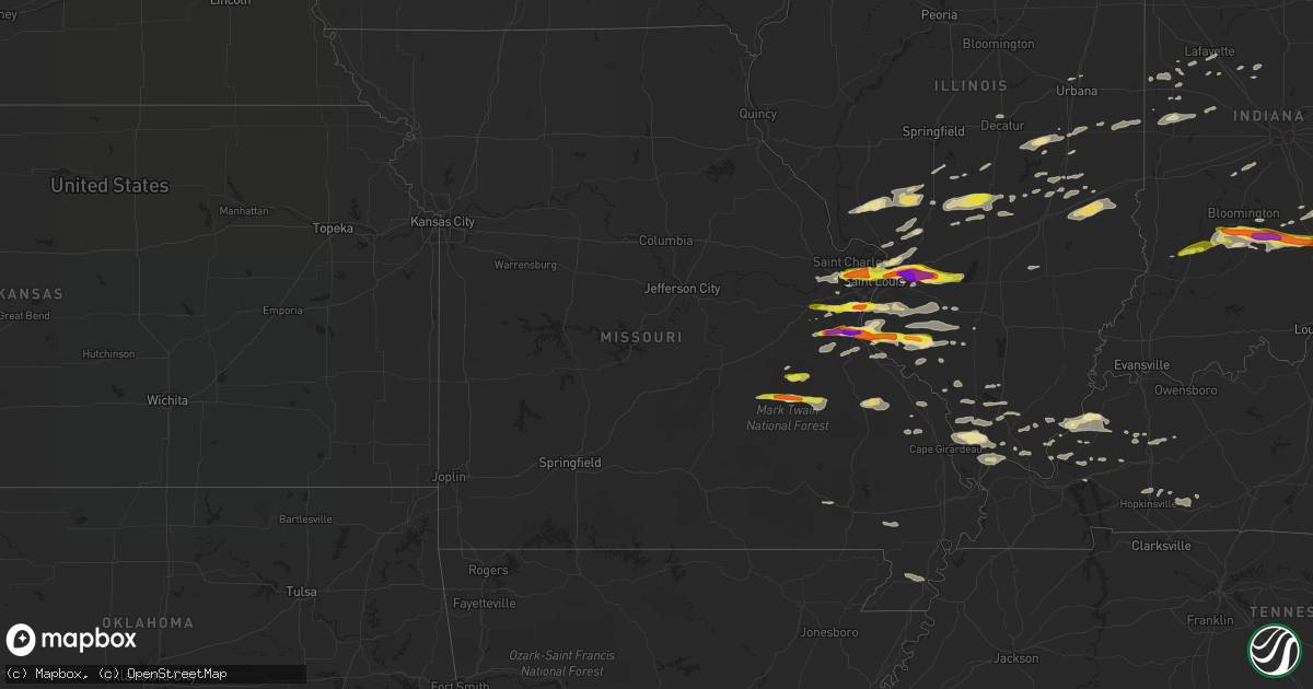
Hail Map in Missouri on November 5, 2017
Get this storm
November 5 map
$229
one time, instant access
Download today. No call, no setup
Keep the $229
Bought the map and want the full workflow? Apply the entire $229 to a subscription within 7 days. None of it is wasted.
Every map, not just this one
This buys you this map. Subscription and you get every map we run, in the markets you choose from a few cities to whole states to nationwide. Plus real-time alerts the moment a storm fires.
Contact data
Name, contact info, occupancy, even credit band for addresses in the footprint. You go from where it hit to who to call.
Become the source they trust
Unlimited branding weather history reports on demand. You already have the documented answer ready for the property owner, and you are the one who showed up with it.
Property data and RoofTrace estimates
Pull up any address you have got, its value and the exact code rules for that jurisdiction, straight from One Click Code. Then RoofTrace estimates the squares, pitch, and roof value, priced the way you price.
Storm reports in Missouri
Missouri
| Date | Description |
|---|---|
| 11/05/20173:42 PM CST | A local report indicates 1.00 inch wind near 1 E VIBURNUM |
| 11/05/20173:42 PM CST | Twitter report. |
| 11/05/20173:42 PM CST | A local report indicates 1.75 inch wind near FESTUS |
| 11/05/20173:41 PM CST | A local report indicates 2.00 inch wind near 2 NE HEMATITE |
| 11/05/20173:40 PM CST | A local report indicates 1.25 inch wind near 1 W HERCULANEUM |
| 11/05/20173:40 PM CST | Twitter report. |
| 11/05/20173:38 PM CST | A local report indicates 1.00 inch wind near VIBURNUM |
| 11/05/20173:36 PM CST | A local report indicates 1.00 inch wind near 2 NE HEMATITE |
| 11/05/20173:30 PM CST | A local report indicates 1.75 inch wind near HILLSBORO |
| 11/05/20173:29 PM CST | Still hailing. |
| 11/05/20173:05 PM CST | Twitter report. |
| 11/05/20173:03 PM CST | A local report indicates 1.75 inch wind near ARNOLD |
| 11/05/20172:51 PM CST | Damage to automobiles in area. |
| 11/05/20172:31 PM CST | A local report indicates 1.50 inch wind near 1 SE MARYLAND HEIGHTS |
| 11/05/20172:28 PM CST | Via broadcast media/social media post |
| 11/05/20172:28 PM CST | A local report indicates 1.25 inch wind near UNIVERSITY CITY |
| 11/05/20172:28 PM CST | Pershing avenue area. |
| 11/05/20172:27 PM CST | Pasadena hills |
| 11/05/20172:25 PM CST | A local report indicates 1.00 inch wind near CLAYTON |
| 11/05/20172:25 PM CST | Fell for almost 5 minutes. |
| 11/05/20172:25 PM CST | A local report indicates 1.00 inch wind near ST. JOHN |
| 11/05/20172:24 PM CST | A local report indicates 1.00 inch wind near ST. ANN |
| 11/05/20172:20 PM CST | A local report indicates 1.00 inch wind near OLIVETTE |
| 11/05/20172:20 PM CST | Just south of i270 and i70 interchange. |
| 11/05/20172:18 PM CST | At desmet high school. |
| 11/05/20172:17 PM CST | A local report indicates 1.75 inch wind near 2 NW OLIVETTE |
| 11/05/20172:17 PM CST | A local report indicates 1.50 inch wind near 1 SE MARYLAND HEIGHTS |
| 11/05/20172:15 PM CST | Power lines down at intersection of olive blvd and hwy 141. |
| 11/05/20171:54 PM CST | A local report indicates 58 MPH wind near 3 W CHESTERFIELD |
Cities Impacted by Hail Map on November 5, 2017
- Windsor, IL
- Gays, IL
- Marble Hill, MO
- Saint Jacob, IL
- Troy, IL
- Lovington, IL
- Arthur, IL
- Crystal City, MO
- Pevely, MO
- Valmeyer, IL
- Festus, MO
- Fults, IL
- Herculaneum, MO
- Hillsboro, MO
- De Soto, MO
- Goreville, IL
- Maryland Heights, MO
- Saint Louis, MO
- Chesterfield, MO
- Saint Ann, MO
- Arnold, MO
- Fenton, MO
- High Ridge, MO
- Imperial, MO
- Rosiclare, IL
- Bloomington, IN
- Springville, IN
- Norman, IN
- Heltonville, IN
- Bedford, IN
- Freetown, IN
- Seymour, IN
- Bloomfield, IN
- Brownstown, IN
- East Saint Louis, IL
- Aviston, IL
- Granite City, IL
- Trenton, IL
- Highland, IL
- Collinsville, IL
- Maryville, IL
- Columbus, IN
- Hartsville, IN
- Viburnum, MO
- Davisville, MO
- Bixby, MO
- Murphysboro, IL
- Ava, IL
- Evansville, IL
- Red Bud, IL
- Dittmer, MO
- Waterloo, IL
- Prairie Du Rocher, IL
- Sparta, IL
- Cutler, IL
- Grubville, MO
- Baldwin, IL
- Coulterville, IL
- Rockbridge, IL
- Medora, IL
- Kane, IL
- Tuscola, IL
- Wolcottville, IN
- Kendallville, IN
- Hudson, IN
- Pleasant Lake, IN
- Staunton, IL
- Belleview, MO
- Casey, IL
- Hidalgo, IL
- Greenup, IL
- Yale, IL
- Metropolis, IL
- Irving, IL
- Ramsey, IL
- Rosamond, IL
- Oconee, IL
- Hillsboro, IL
- Butler, IL
- Nokomis, IL
- Witt, IL
- Pana, IL
- Fillmore, IL
- Grandin, MO
- Poplar Bluff, MO
- Madisonville, KY
- Glen Carbon, IL
- Lebanon, IL
- Madison, IL
- Marine, IL
- Cedar Hill, MO
- Edwardsville, IL
- Breese, IL
- Venice, IL
- Pinckneyville, IL
- Tamaroa, IL
- Nashville, IL
- Worden, IL
- Bunker Hill, IL
- Dorsey, IL
- Moro, IL
- Jonesboro, IL
- Anna, IL
- Dongola, IL
- Middle Brook, MO
- Boss, MO
- Salem, MO
- Ironton, MO
- Cherryville, MO
- Fredericktown, MO
- Herod, IL
- Eddyville, IL
- Golconda, IL
- Cave In Rock, IL
- Sturgis, KY
- Rome City, IN
- Ligonier, IN
- Wawaka, IN
- Elkton, KY
- Coffeen, IL
- Columbia, IL
- Millstadt, IL
- Catawissa, MO
- Belleville, IL
- Eureka, MO
- Freeburg, IL
- Smithton, IL
- House Springs, MO
- Pacific, MO
- Elizabethtown, IN
- Westport, IN
- Avoca, IN
- Ashley, IN
- South Milford, IN
- Belknap, IL
- Greensburg, IN
- Odon, IN
- Steelville, MO
- Potosi, MO
- Herrin, IL
- Carterville, IL
- Fredonia, KY
- Marion, KY
- Salem, KY
- Nashville, IN
- Perryville, MO
- Friedheim, MO
- Sedgewickville, MO
- Litchfield, IL
- O'Fallon, IL
- Caseyville, IL
- Saint Charles, MO
- Carlyle, IL
- Lovejoy, IL
- East Alton, IL
- Hamel, IL
- Okawville, IL
- Addieville, IL
- Martinsville, IN
- Mooresville, IN
- Monrovia, IN
- Mattoon, IL
- Palmer, IL
- Kingman, IN
- Marshall, IN
- Bloomingdale, IN
- Elizabethtown, IL
- Sullivan, IL
- Thomasboro, IL
- Lafayette, IN
- Carlinville, IL
- Chesterfield, IL
- Jerseyville, IL
- Kuttawa, KY
- Veedersburg, IN
- Nilwood, IL
- Girard, IL
- Sacramento, KY
- Owensburg, IN
- Medora, IN
- Nebo, KY
- Manitou, KY
- Hayti, MO
- Bragg City, MO
- Decatur, IL
- Forsyth, IL
- Carbondale, IL
- Marion, IL
- Bingham, IL
- Johnston City, IL
- Corunna, IN
- Cromwell, IN
- Montrose, IL
- Jewett, IL
- Martinsville, IL
- Elnora, IN
- Cottage Hills, IL
- Bethalto, IL
- Alton, IL
- Robertsville, MO
- Frankfort, IN
- Michigantown, IN
- Solsberry, IN
- Attica, IN
- Wingate, IN
- Farmington, MO
- Celina, OH
- Camargo, IL
- Villa Grove, IL
- Bernie, MO
- Dexter, MO
- Providence, KY
- Dixon, KY
- Xenia, IL
- Louisville, IL
- Assumption, IL
- Taylorville, IL
- Owaneco, IL
- Simpson, IL
- Vienna, IL
- Percy, IL
- Millersville, MO
- Oak Ridge, MO
- Jackson, MO
- Williamsport, IN
- Covington, IN
- New Baden, IL
- Marissa, IL
- Mascoutah, IL
- Du Bois, IL
- Champaign, IL
- Hanson, KY
- Pawnee, IL
- Virden, IL
- Farmersville, IL
- Lewisburg, KY
- Sharon Grove, KY
- Clarks Hill, IN
- Grand Chain, IL
- Villa Ridge, IL
- Kevil, KY
- Pulaski, IL
- Olmsted, IL
- Ullin, IL
- La Center, KY
- Morrisonville, IL
- Lakewood, IL
- Cowden, IL
- Syracuse, IN
- Oolitic, IN
- Chrisman, IL
- Ridge Farm, IL
- Metcalf, IL
- Wildwood, MO
- Defiance, MO
- Ballwin, MO
- Crawfordsville, IN
- New Ross, IN
- Westpoint, IN
- Eaton, IN
- Beecher City, IL
- Raymond, IL
- Tower Hill, IL
- New Burnside, IL
- Creal Springs, IL
- Ozark, IL
- Albion, IN
- Smithland, KY
- Hampton, KY
- Alto Pass, IL
- Wolf Lake, IL
- Cobden, IL
- Buncombe, IL
- Makanda, IL
- Edwardsport, IN
- Bethany, IL
- Dalton City, IL
- Arcola, IL
- Atwood, IL
- Montezuma, IN
- Waveland, IN
- New Athens, IL
- Gillespie, IL
- Wilsonville, IL
- Russellville, KY
- Plainville, IN
- Bloomsdale, MO
- Sainte Genevieve, MO
- Clayton, OH
- Englewood, OH
- Hillsboro, IN
- Cadet, MO
- Blackwell, MO
- Cypress, IL
- McClure, IL
- Cape Girardeau, MO
- Pomona, IL
- Princeton, KY
- Saint Clair, MO
- Dawson Springs, KY
- Gaston, IN
- Muncie, IN
- Mellott, IN
- Elwood, IN
- Summitville, IN
- Palmyra, IL
- Hettick, IL
- Waggoner, IL
- Gosport, IN
- Quincy, IN
- Paragon, IN
- Trilla, IL
- Neoga, IL
- Kirklin, IN
- Newman, IL
- Toledo, IL
- Perrysburg, OH
- Oakdale, IL
- Lenzburg, IL
- Hopkinsville, KY
- Frohna, MO
- Walsh, IL
- Lonedell, MO
- Richwoods, MO
- Clay, KY
- Burna, KY
- Crofton, KY
- Shelbyville, IL
- Belgrade, MO
- Charleston, IL
- Lerna, IL
- Stewardson, IL
- Jacob, IL
- Romney, IN
- Steeleville, IL
- Chester, IL
- Bridgeton, MO
- Villa Ridge, MO
- Tilden, IL
- Newberry, IN
- Crane, IN
- Sandborn, IN
- Scotland, IN
- North Vernon, IN


