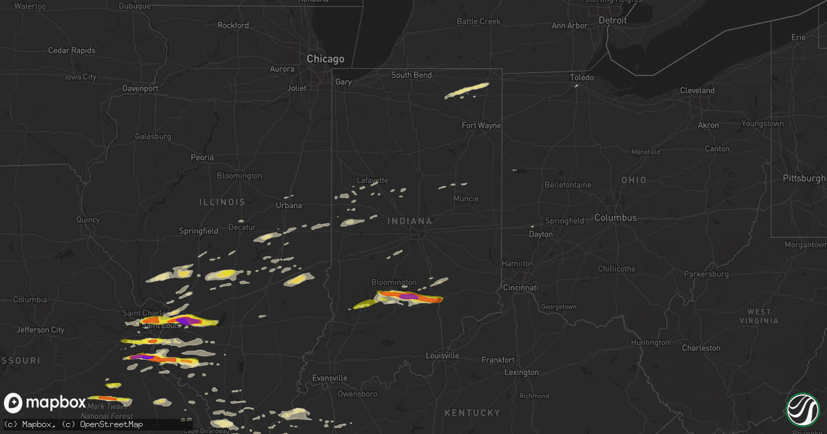
Hail Map in Indiana on November 5, 2017
Get this storm
November 5 map
$229
one time, instant access
Download today. No call, no setup
Keep the $229
Bought the map and want the full workflow? Apply the entire $229 to a subscription within 7 days. None of it is wasted.
Every map, not just this one
This buys you this map. Subscription and you get every map we run, in the markets you choose from a few cities to whole states to nationwide. Plus real-time alerts the moment a storm fires.
Contact data
Name, contact info, occupancy, even credit band for addresses in the footprint. You go from where it hit to who to call.
Become the source they trust
Unlimited branding weather history reports on demand. You already have the documented answer ready for the property owner, and you are the one who showed up with it.
Property data and RoofTrace estimates
Pull up any address you have got, its value and the exact code rules for that jurisdiction, straight from One Click Code. Then RoofTrace estimates the squares, pitch, and roof value, priced the way you price.
Storm reports in Indiana
Indiana
| Date | Description |
|---|---|
| 11/05/20175:40 PM CST | Tree limbs snapped along county road 1200 south. Relayed via social media. |
| 11/05/20175:32 PM CST | Several large tree limbs down near state road 3. Relayed via law enforcement. Time estimated via radar. |
| 11/05/20174:49 PM CST | Several 6-8 inch tree limbs snapped. Relayed via twitter. Time estimated via radar. |
| 11/05/20172:44 PM CST | Tree and utility lines down at 4401 north 300 east. Time roughly estimated based on radar. |
| 11/05/20172:28 PM CST | Utility pole with live wires fallen into a vehicle with entrapment at north county road 600 west and state road 28. Time is roughly estimated based on radar. |
| 11/05/20172:12 PM CST | Estimated wind of 65 mph...pea size hail..and small tree limbs down. Power was off and on. Reported at 805 west dunn avenue... Muncie... Indiana. |
| 11/05/20172:11 PM CST | Six-inch diameter tree limbs down from a live tree on west main street. |
| 11/05/20172:11 PM CST | Reported in the 600 block of ashland avenue... Muncie... Indiana. Time is approximate and based on radar. |
| 11/05/20172:11 PM CST | Six-inch diameter tree limb torn off tree at jackson street and university avenue in muncie... Indiana. Time is estimated based on radar. |
| 11/05/20172:11 PM CST | Tree into a house in the 500 block of greenbriar road. Time is roughly estimated based on radar. |
| 11/05/20172:11 PM CST | Report of two trees down in the 300 block of schroeder avenue. Time is estimated based on radar.. |
| 11/05/20171:38 PM CST | Secondhand report of damage to silos near county roads 1550 north and 500 west in madison county. |
| 11/05/20171:30 PM CST | Destroyed shed on the south side of tipton. |
| 11/05/20171:30 PM CST | Measured wind gust to 64 mph destroyed a shed on the south side of tipton. |
| 11/05/20171:21 PM CST | Roof damage and pea size hail at state road 421 and county road 400 south. |
| 11/05/20171:05 PM CST | Utility pole blown almost all the way over onto south county road 400 east near east state road 38. Time is roughly based on radar. |
| 11/05/201712:57 PM CST | Residents reported a small tornado touchdown. Lots of damage reported. Pictures are being taken. |
| 11/05/201712:57 PM CST | Location correction. Residents reported a small tornado touchdown; barn gone... Missing roof on house. |
| 11/05/201712:50 PM CST | Damage to ohio valley pipeline substation. Gas reported leaking. Probable tornado impact. Time estimated by radar. |
| 11/05/201712:50 PM CST | Small barn destroyed. |
| 11/05/201712:48 PM CST | Three electric poles have been blown down at or near the intersection of east county line road south and south county road 1000 east...necessitating road closure. Time |
| 11/05/201712:45 PM CST | Estimated winds of 50 to 55 mph. |
| 11/05/201712:40 PM CST | Building damage. Scattered debris in all directions across fields. Roof gone from a barn. |
| 11/05/201712:40 PM CST | Significant tree damage. Some trees sheared off. |
| 11/05/201712:20 PM CST | Widespread damage across portions of springville near popcorn road. Mobile home damaged... Trailer knocked over and numerous trees damaged. |
| 11/05/201712:17 PM CST | Ten-inch diameter tree blown down and a six-inch diameter tree limb torn down next to it between walnut street and state road 3 on eaton-wheeling pike. Time is very rou |
| 11/05/201711:56 AM CST | A couple of out buildings destroyed and there were numerous 2 to 3-foot diameter live trees broken off above the ground...all appear to be from straight line wind per m |
| 11/05/201711:53 AM CST | Utility poles and lines down on state road 13 between 1300 n and 1400 n... Presumably damaged by thunderstorm winds. Time is approximate. |
| 11/05/201711:53 AM CST | Multiple utility lines down on 1550 north between 300 west and 600 west... Closing the road. Time very roughly approximated from radar. |
| 11/05/201711:27 AM CST | A local report indicates 1.25 inch wind near ELNORA |
| 11/05/201711:20 AM CST | Spotter estimates 60 mph wind gust. |
| 11/05/201710:10 AM CST | Tree down on roadway. |
| 11/05/201710:10 AM CST | Corrected location. Tree down on roadway. |
| 11/05/20179:45 AM CST | Two large trees downed onto power lines on spring beach road. |
| 11/04/201711:21 PM CDT | Metal roof damage to cinder block garage. Winds estimated at 65 mph. |
| 11/04/201711:20 PM CDT | Estimated peak winds: 90-95 mph. Path length: 0.5 miles. Path width: 50-70 yards. Severe damage done to several barns... Street signs... And metal poles were bent and s |
| 11/04/201711:18 PM CDT | Large branches broken. Estimated wind speeds of 62 mph. |
| 11/04/201711:18 PM CDT | Tree blown over rubber hill road. |
| 11/04/201711:16 PM CDT | Estimated peak winds: 90-95 mph. Path length: 0.25 miles. Path width: 30-40 yards. Significant damage done the the upper portion of feed mill... Power poles severely be |
| 11/04/201711:04 PM CDT | Estimated peak winds: 80 mph. Path length: 0.6 miles. Path width: 300-350 yards. Tree and minor property damaged occurred near the 1600 block of sw washington school ro |
| 11/04/20178:10 PM CDT | Few trees down in paoli. Time estimated by radar. |
Cities Impacted by Hail Map on November 5, 2017
- Windsor, IL
- Gays, IL
- Marble Hill, MO
- Saint Jacob, IL
- Troy, IL
- Lovington, IL
- Arthur, IL
- Crystal City, MO
- Pevely, MO
- Valmeyer, IL
- Festus, MO
- Fults, IL
- Herculaneum, MO
- Hillsboro, MO
- De Soto, MO
- Goreville, IL
- Maryland Heights, MO
- Saint Louis, MO
- Chesterfield, MO
- Saint Ann, MO
- Arnold, MO
- Fenton, MO
- High Ridge, MO
- Imperial, MO
- Rosiclare, IL
- Bloomington, IN
- Springville, IN
- Norman, IN
- Heltonville, IN
- Bedford, IN
- Freetown, IN
- Seymour, IN
- Bloomfield, IN
- Brownstown, IN
- East Saint Louis, IL
- Aviston, IL
- Granite City, IL
- Trenton, IL
- Highland, IL
- Collinsville, IL
- Maryville, IL
- Columbus, IN
- Hartsville, IN
- Viburnum, MO
- Davisville, MO
- Bixby, MO
- Murphysboro, IL
- Ava, IL
- Evansville, IL
- Red Bud, IL
- Dittmer, MO
- Waterloo, IL
- Prairie Du Rocher, IL
- Sparta, IL
- Cutler, IL
- Grubville, MO
- Baldwin, IL
- Coulterville, IL
- Rockbridge, IL
- Medora, IL
- Kane, IL
- Tuscola, IL
- Wolcottville, IN
- Kendallville, IN
- Hudson, IN
- Pleasant Lake, IN
- Staunton, IL
- Belleview, MO
- Casey, IL
- Hidalgo, IL
- Greenup, IL
- Yale, IL
- Metropolis, IL
- Irving, IL
- Ramsey, IL
- Rosamond, IL
- Oconee, IL
- Hillsboro, IL
- Butler, IL
- Nokomis, IL
- Witt, IL
- Pana, IL
- Fillmore, IL
- Grandin, MO
- Poplar Bluff, MO
- Madisonville, KY
- Glen Carbon, IL
- Lebanon, IL
- Madison, IL
- Marine, IL
- Cedar Hill, MO
- Edwardsville, IL
- Breese, IL
- Venice, IL
- Pinckneyville, IL
- Tamaroa, IL
- Nashville, IL
- Worden, IL
- Bunker Hill, IL
- Dorsey, IL
- Moro, IL
- Jonesboro, IL
- Anna, IL
- Dongola, IL
- Middle Brook, MO
- Boss, MO
- Salem, MO
- Ironton, MO
- Cherryville, MO
- Fredericktown, MO
- Herod, IL
- Eddyville, IL
- Golconda, IL
- Cave In Rock, IL
- Sturgis, KY
- Rome City, IN
- Ligonier, IN
- Wawaka, IN
- Elkton, KY
- Coffeen, IL
- Columbia, IL
- Millstadt, IL
- Catawissa, MO
- Belleville, IL
- Eureka, MO
- Freeburg, IL
- Smithton, IL
- House Springs, MO
- Pacific, MO
- Elizabethtown, IN
- Westport, IN
- Avoca, IN
- Ashley, IN
- South Milford, IN
- Belknap, IL
- Greensburg, IN
- Odon, IN
- Steelville, MO
- Potosi, MO
- Herrin, IL
- Carterville, IL
- Fredonia, KY
- Marion, KY
- Salem, KY
- Nashville, IN
- Perryville, MO
- Friedheim, MO
- Sedgewickville, MO
- Litchfield, IL
- O'Fallon, IL
- Caseyville, IL
- Saint Charles, MO
- Carlyle, IL
- Lovejoy, IL
- East Alton, IL
- Hamel, IL
- Okawville, IL
- Addieville, IL
- Martinsville, IN
- Mooresville, IN
- Monrovia, IN
- Mattoon, IL
- Palmer, IL
- Kingman, IN
- Marshall, IN
- Bloomingdale, IN
- Elizabethtown, IL
- Sullivan, IL
- Thomasboro, IL
- Lafayette, IN
- Carlinville, IL
- Chesterfield, IL
- Jerseyville, IL
- Kuttawa, KY
- Veedersburg, IN
- Nilwood, IL
- Girard, IL
- Sacramento, KY
- Owensburg, IN
- Medora, IN
- Nebo, KY
- Manitou, KY
- Hayti, MO
- Bragg City, MO
- Decatur, IL
- Forsyth, IL
- Carbondale, IL
- Marion, IL
- Bingham, IL
- Johnston City, IL
- Corunna, IN
- Cromwell, IN
- Montrose, IL
- Jewett, IL
- Martinsville, IL
- Elnora, IN
- Cottage Hills, IL
- Bethalto, IL
- Alton, IL
- Robertsville, MO
- Frankfort, IN
- Michigantown, IN
- Solsberry, IN
- Attica, IN
- Wingate, IN
- Farmington, MO
- Celina, OH
- Camargo, IL
- Villa Grove, IL
- Bernie, MO
- Dexter, MO
- Providence, KY
- Dixon, KY
- Xenia, IL
- Louisville, IL
- Assumption, IL
- Taylorville, IL
- Owaneco, IL
- Simpson, IL
- Vienna, IL
- Percy, IL
- Millersville, MO
- Oak Ridge, MO
- Jackson, MO
- Williamsport, IN
- Covington, IN
- New Baden, IL
- Marissa, IL
- Mascoutah, IL
- Du Bois, IL
- Champaign, IL
- Hanson, KY
- Pawnee, IL
- Virden, IL
- Farmersville, IL
- Lewisburg, KY
- Sharon Grove, KY
- Clarks Hill, IN
- Grand Chain, IL
- Villa Ridge, IL
- Kevil, KY
- Pulaski, IL
- Olmsted, IL
- Ullin, IL
- La Center, KY
- Morrisonville, IL
- Lakewood, IL
- Cowden, IL
- Syracuse, IN
- Oolitic, IN
- Chrisman, IL
- Ridge Farm, IL
- Metcalf, IL
- Wildwood, MO
- Defiance, MO
- Ballwin, MO
- Crawfordsville, IN
- New Ross, IN
- Westpoint, IN
- Eaton, IN
- Beecher City, IL
- Raymond, IL
- Tower Hill, IL
- New Burnside, IL
- Creal Springs, IL
- Ozark, IL
- Albion, IN
- Smithland, KY
- Hampton, KY
- Alto Pass, IL
- Wolf Lake, IL
- Cobden, IL
- Buncombe, IL
- Makanda, IL
- Edwardsport, IN
- Bethany, IL
- Dalton City, IL
- Arcola, IL
- Atwood, IL
- Montezuma, IN
- Waveland, IN
- New Athens, IL
- Gillespie, IL
- Wilsonville, IL
- Russellville, KY
- Plainville, IN
- Bloomsdale, MO
- Sainte Genevieve, MO
- Clayton, OH
- Englewood, OH
- Hillsboro, IN
- Cadet, MO
- Blackwell, MO
- Cypress, IL
- McClure, IL
- Cape Girardeau, MO
- Pomona, IL
- Princeton, KY
- Saint Clair, MO
- Dawson Springs, KY
- Gaston, IN
- Muncie, IN
- Mellott, IN
- Elwood, IN
- Summitville, IN
- Palmyra, IL
- Hettick, IL
- Waggoner, IL
- Gosport, IN
- Quincy, IN
- Paragon, IN
- Trilla, IL
- Neoga, IL
- Kirklin, IN
- Newman, IL
- Toledo, IL
- Perrysburg, OH
- Oakdale, IL
- Lenzburg, IL
- Hopkinsville, KY
- Frohna, MO
- Walsh, IL
- Lonedell, MO
- Richwoods, MO
- Clay, KY
- Burna, KY
- Crofton, KY
- Shelbyville, IL
- Belgrade, MO
- Charleston, IL
- Lerna, IL
- Stewardson, IL
- Jacob, IL
- Romney, IN
- Steeleville, IL
- Chester, IL
- Bridgeton, MO
- Villa Ridge, MO
- Tilden, IL
- Newberry, IN
- Crane, IN
- Sandborn, IN
- Scotland, IN
- North Vernon, IN


