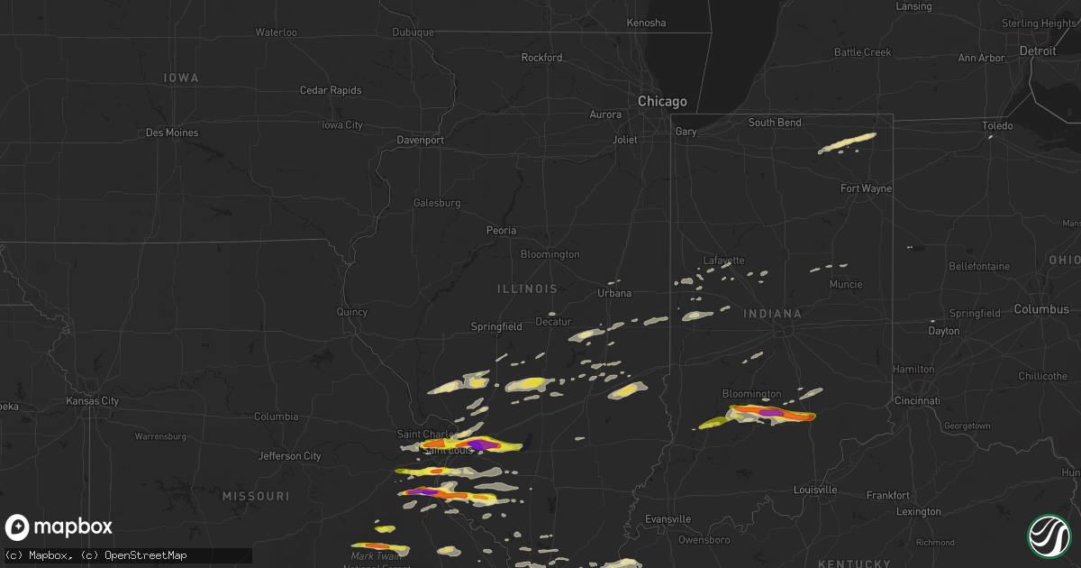
Hail Map in Illinois on November 5, 2017
Get this storm
November 5 map
$229
one time, instant access
Download today. No call, no setup
Keep the $229
Bought the map and want the full workflow? Apply the entire $229 to a subscription within 7 days. None of it is wasted.
Every map, not just this one
This buys you this map. Subscription and you get every map we run, in the markets you choose from a few cities to whole states to nationwide. Plus real-time alerts the moment a storm fires.
Contact data
Name, contact info, occupancy, even credit band for addresses in the footprint. You go from where it hit to who to call.
Become the source they trust
Unlimited branding weather history reports on demand. You already have the documented answer ready for the property owner, and you are the one who showed up with it.
Property data and RoofTrace estimates
Pull up any address you have got, its value and the exact code rules for that jurisdiction, straight from One Click Code. Then RoofTrace estimates the squares, pitch, and roof value, priced the way you price.
Storm reports in Illinois
Illinois
| Date | Description |
|---|---|
| 11/05/20175:37 PM CST | 3 power poles leaning |
| 11/05/20175:32 PM CST | Vehicle window broken |
| 11/05/20175:24 PM CST | South of tornado touchdown area... Metal siding peeled off home and rotted tree uprooted. |
| 11/05/20175:22 PM CST | Path length 6.9 miles... Max width 50 yards. Estimated max wind 105 mph. Main damage to a residence near the start of the track... Damaging the roof of a house... Destr |
| 11/05/20174:45 PM CST | A local report indicates 1.25 inch wind near 1 N SPARTA |
| 11/05/20174:44 PM CST | A local report indicates 1.50 inch wind near 2 NW SPARTA |
| 11/05/20174:33 PM CST | A local report indicates 1.00 inch wind near BALDWIN |
| 11/05/20174:19 PM CST | Delayed report. A few small trees and numerous large tree branches blown down. Time estimated. |
| 11/05/20174:12 PM CST | A local report indicates 1.00 inch wind near RED BUD |
| 11/05/20173:58 PM CST | A local report indicates 1.25 inch wind near 2 E ST. JACOB |
| 11/05/20173:56 PM CST | Small tree limbs blown down. |
| 11/05/20173:50 PM CST | A local report indicates 1.00 inch wind near 3 WSW MAEYSTOWN |
| 11/05/20173:43 PM CST | Spotter reported that sheet metal from an unknown source was lifted into the air near his location. |
| 11/05/20173:40 PM CST | Delayed report. Power pole and power lines blown down. Several tree limbs blown down. Time estimated. |
| 11/05/20173:36 PM CST | Spotter reported that sheet metal from an unknown source was lifted into the air near his location. |
| 11/05/20173:15 PM CST | Metal storage building damaged. |
| 11/05/20173:00 PM CST | A local report indicates 1.75 inch wind near 2 N TRENTON |
| 11/05/20172:58 PM CST | A local report indicates 1.00 inch wind near ST. JACOB |
| 11/05/20172:55 PM CST | Quarter to half dollar size lasted over 10 minutes. |
| 11/05/20172:52 PM CST | A local report indicates 2.50 inch wind near 1 S TROY |
| 11/05/20172:51 PM CST | A local report indicates 1.75 inch wind near TROY |
| 11/05/20172:50 PM CST | A local report indicates 2.50 inch wind near 1 NE COLLINSVILLE |
| 11/05/20172:49 PM CST | A local report indicates 1.50 inch wind near CASEYVILLE |
| 11/05/20172:47 PM CST | Twitter report. |
| 11/05/20172:47 PM CST | A local report indicates 1.00 inch wind near CASEYVILLE |
| 11/05/20172:36 PM CST | A local report indicates 1.25 inch wind near VENICE |
| 11/05/20172:10 PM CST | Delayed report. Power line blown down on the northwest side of town. Time estimated. |
| 11/04/201711:27 PM CDT | A local report indicates 1.25 inch wind near 2 E ST. JACOB |
| 11/04/20179:12 PM CDT | Tree down at the housing authority... And numerous trees down across the county. |
Cities Impacted by Hail Map on November 5, 2017
- Windsor, IL
- Gays, IL
- Marble Hill, MO
- Saint Jacob, IL
- Troy, IL
- Lovington, IL
- Arthur, IL
- Crystal City, MO
- Pevely, MO
- Valmeyer, IL
- Festus, MO
- Fults, IL
- Herculaneum, MO
- Hillsboro, MO
- De Soto, MO
- Goreville, IL
- Maryland Heights, MO
- Saint Louis, MO
- Chesterfield, MO
- Saint Ann, MO
- Arnold, MO
- Fenton, MO
- High Ridge, MO
- Imperial, MO
- Rosiclare, IL
- Bloomington, IN
- Springville, IN
- Norman, IN
- Heltonville, IN
- Bedford, IN
- Freetown, IN
- Seymour, IN
- Bloomfield, IN
- Brownstown, IN
- East Saint Louis, IL
- Aviston, IL
- Granite City, IL
- Trenton, IL
- Highland, IL
- Collinsville, IL
- Maryville, IL
- Columbus, IN
- Hartsville, IN
- Viburnum, MO
- Davisville, MO
- Bixby, MO
- Murphysboro, IL
- Ava, IL
- Evansville, IL
- Red Bud, IL
- Dittmer, MO
- Waterloo, IL
- Prairie Du Rocher, IL
- Sparta, IL
- Cutler, IL
- Grubville, MO
- Baldwin, IL
- Coulterville, IL
- Rockbridge, IL
- Medora, IL
- Kane, IL
- Tuscola, IL
- Wolcottville, IN
- Kendallville, IN
- Hudson, IN
- Pleasant Lake, IN
- Staunton, IL
- Belleview, MO
- Casey, IL
- Hidalgo, IL
- Greenup, IL
- Yale, IL
- Metropolis, IL
- Irving, IL
- Ramsey, IL
- Rosamond, IL
- Oconee, IL
- Hillsboro, IL
- Butler, IL
- Nokomis, IL
- Witt, IL
- Pana, IL
- Fillmore, IL
- Grandin, MO
- Poplar Bluff, MO
- Madisonville, KY
- Glen Carbon, IL
- Lebanon, IL
- Madison, IL
- Marine, IL
- Cedar Hill, MO
- Edwardsville, IL
- Breese, IL
- Venice, IL
- Pinckneyville, IL
- Tamaroa, IL
- Nashville, IL
- Worden, IL
- Bunker Hill, IL
- Dorsey, IL
- Moro, IL
- Jonesboro, IL
- Anna, IL
- Dongola, IL
- Middle Brook, MO
- Boss, MO
- Salem, MO
- Ironton, MO
- Cherryville, MO
- Fredericktown, MO
- Herod, IL
- Eddyville, IL
- Golconda, IL
- Cave In Rock, IL
- Sturgis, KY
- Rome City, IN
- Ligonier, IN
- Wawaka, IN
- Elkton, KY
- Coffeen, IL
- Columbia, IL
- Millstadt, IL
- Catawissa, MO
- Belleville, IL
- Eureka, MO
- Freeburg, IL
- Smithton, IL
- House Springs, MO
- Pacific, MO
- Elizabethtown, IN
- Westport, IN
- Avoca, IN
- Ashley, IN
- South Milford, IN
- Belknap, IL
- Greensburg, IN
- Odon, IN
- Steelville, MO
- Potosi, MO
- Herrin, IL
- Carterville, IL
- Fredonia, KY
- Marion, KY
- Salem, KY
- Nashville, IN
- Perryville, MO
- Friedheim, MO
- Sedgewickville, MO
- Litchfield, IL
- O'Fallon, IL
- Caseyville, IL
- Saint Charles, MO
- Carlyle, IL
- Lovejoy, IL
- East Alton, IL
- Hamel, IL
- Okawville, IL
- Addieville, IL
- Martinsville, IN
- Mooresville, IN
- Monrovia, IN
- Mattoon, IL
- Palmer, IL
- Kingman, IN
- Marshall, IN
- Bloomingdale, IN
- Elizabethtown, IL
- Sullivan, IL
- Thomasboro, IL
- Lafayette, IN
- Carlinville, IL
- Chesterfield, IL
- Jerseyville, IL
- Kuttawa, KY
- Veedersburg, IN
- Nilwood, IL
- Girard, IL
- Sacramento, KY
- Owensburg, IN
- Medora, IN
- Nebo, KY
- Manitou, KY
- Hayti, MO
- Bragg City, MO
- Decatur, IL
- Forsyth, IL
- Carbondale, IL
- Marion, IL
- Bingham, IL
- Johnston City, IL
- Corunna, IN
- Cromwell, IN
- Montrose, IL
- Jewett, IL
- Martinsville, IL
- Elnora, IN
- Cottage Hills, IL
- Bethalto, IL
- Alton, IL
- Robertsville, MO
- Frankfort, IN
- Michigantown, IN
- Solsberry, IN
- Attica, IN
- Wingate, IN
- Farmington, MO
- Celina, OH
- Camargo, IL
- Villa Grove, IL
- Bernie, MO
- Dexter, MO
- Providence, KY
- Dixon, KY
- Xenia, IL
- Louisville, IL
- Assumption, IL
- Taylorville, IL
- Owaneco, IL
- Simpson, IL
- Vienna, IL
- Percy, IL
- Millersville, MO
- Oak Ridge, MO
- Jackson, MO
- Williamsport, IN
- Covington, IN
- New Baden, IL
- Marissa, IL
- Mascoutah, IL
- Du Bois, IL
- Champaign, IL
- Hanson, KY
- Pawnee, IL
- Virden, IL
- Farmersville, IL
- Lewisburg, KY
- Sharon Grove, KY
- Clarks Hill, IN
- Grand Chain, IL
- Villa Ridge, IL
- Kevil, KY
- Pulaski, IL
- Olmsted, IL
- Ullin, IL
- La Center, KY
- Morrisonville, IL
- Lakewood, IL
- Cowden, IL
- Syracuse, IN
- Oolitic, IN
- Chrisman, IL
- Ridge Farm, IL
- Metcalf, IL
- Wildwood, MO
- Defiance, MO
- Ballwin, MO
- Crawfordsville, IN
- New Ross, IN
- Westpoint, IN
- Eaton, IN
- Beecher City, IL
- Raymond, IL
- Tower Hill, IL
- New Burnside, IL
- Creal Springs, IL
- Ozark, IL
- Albion, IN
- Smithland, KY
- Hampton, KY
- Alto Pass, IL
- Wolf Lake, IL
- Cobden, IL
- Buncombe, IL
- Makanda, IL
- Edwardsport, IN
- Bethany, IL
- Dalton City, IL
- Arcola, IL
- Atwood, IL
- Montezuma, IN
- Waveland, IN
- New Athens, IL
- Gillespie, IL
- Wilsonville, IL
- Russellville, KY
- Plainville, IN
- Bloomsdale, MO
- Sainte Genevieve, MO
- Clayton, OH
- Englewood, OH
- Hillsboro, IN
- Cadet, MO
- Blackwell, MO
- Cypress, IL
- McClure, IL
- Cape Girardeau, MO
- Pomona, IL
- Princeton, KY
- Saint Clair, MO
- Dawson Springs, KY
- Gaston, IN
- Muncie, IN
- Mellott, IN
- Elwood, IN
- Summitville, IN
- Palmyra, IL
- Hettick, IL
- Waggoner, IL
- Gosport, IN
- Quincy, IN
- Paragon, IN
- Trilla, IL
- Neoga, IL
- Kirklin, IN
- Newman, IL
- Toledo, IL
- Perrysburg, OH
- Oakdale, IL
- Lenzburg, IL
- Hopkinsville, KY
- Frohna, MO
- Walsh, IL
- Lonedell, MO
- Richwoods, MO
- Clay, KY
- Burna, KY
- Crofton, KY
- Shelbyville, IL
- Belgrade, MO
- Charleston, IL
- Lerna, IL
- Stewardson, IL
- Jacob, IL
- Romney, IN
- Steeleville, IL
- Chester, IL
- Bridgeton, MO
- Villa Ridge, MO
- Tilden, IL
- Newberry, IN
- Crane, IN
- Sandborn, IN
- Scotland, IN
- North Vernon, IN


