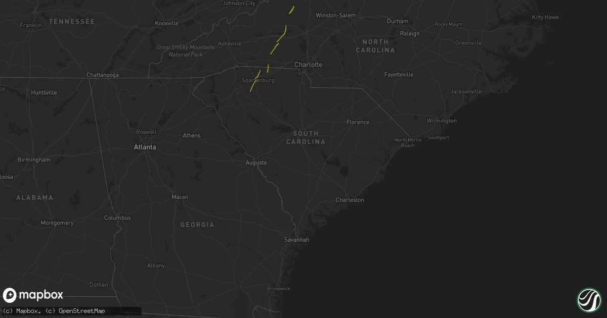
Hail Map in South Carolina on October 23, 2017
Get this storm
October 23 map
$229
one time, instant access
Download today. No call, no setup
Keep the $229
Bought the map and want the full workflow? Apply the entire $229 to a subscription within 7 days. None of it is wasted.
Every map, not just this one
This buys you this map. Subscription and you get every map we run, in the markets you choose from a few cities to whole states to nationwide. Plus real-time alerts the moment a storm fires.
Contact data
Name, contact info, occupancy, even credit band for addresses in the footprint. You go from where it hit to who to call.
Become the source they trust
Unlimited branding weather history reports on demand. You already have the documented answer ready for the property owner, and you are the one who showed up with it.
Property data and RoofTrace estimates
Pull up any address you have got, its value and the exact code rules for that jurisdiction, straight from One Click Code. Then RoofTrace estimates the squares, pitch, and roof value, priced the way you price.
Storm reports in South Carolina
South Carolina
| Date | Description |
|---|---|
| 10/23/20176:52 PM CDT | Warning point reported tree down at walterboro road near clubhouse road. |
| 10/23/20176:45 PM CDT | Sc highway patrol reports tree down on peirce road and red oak road. |
| 10/23/20176:44 PM CDT | Warning point reported tree down on car and power lines down near the intersection of wichman street and paul street |
| 10/23/20176:44 PM CDT | Warning point reported trees down on wesley grove road and rehoboth road. |
| 10/23/20176:39 PM CDT | Warning point reported trees down on coolers dairy road and merrick road. |
| 10/23/20176:37 PM CDT | Warning point reported trees down on sniders highway near cypress pond road. |
| 10/23/20175:28 PM CDT | Orangeburg county dispatch reported trees down on cannon bridge road. |
| 10/23/20172:36 PM CDT | Roof of a home on fariview rd. |
| 10/23/20172:30 PM CDT | 2 trees down on battleground rd. |
| 10/23/20172:12 PM CDT | Numerous large trees and powerlines down on w.o. Ezell rd. |
| 10/23/20172:12 PM CDT | Trees snapped at camelot dr and hwy 21. |
| 10/23/20172:10 PM CDT | Trees and branches down at 585 frontage rd near the milliken plant |
| 10/23/20172:01 PM CDT | Several large trees down near anderson mill rd and the tyger river. |
| 10/23/20171:56 PM CDT | Tree through mobile home on greenpond rd. Tree on roof of another mobile home... Horse barn destroyed... And numerous trees and powerlines down on greenpond rd. |
| 10/23/20171:54 PM CDT | Two houses damaged on greenpond rd |
| 10/23/20171:17 PM CDT | Trees down on will hanks rd in honea path |
| 10/22/20179:27 PM CDT | Nws storm survey confirms a tornado touchdown between inman circle and the waccamaw river. Details are available in a public information statement. |
| 10/22/20178:57 PM CDT | Large tree down in roadway |
| 10/22/20178:50 PM CDT | A tree was reported down on highway 41 near t-mart. |
| 10/22/20178:45 PM CDT | Large tree down across roadway at 3507 creek road and w. Shortcut road |
| 10/22/20178:45 PM CDT | A large tree was reported down at the intersection of laughlin rd. And u.s. 301. |
| 10/22/20178:43 PM CDT | A large tree was reportedly blocking the intersection of highway 76 and grice ferry ct. |
| 10/22/20178:32 PM CDT | Commerical sign blown down and a few tree limbs blown down. Sign blown northeastward a signficant distance. |
| 10/22/20178:29 PM CDT | Damage to outbuildings... Large tree limbs down... Metal roofing material wrapped around trees. |
| 10/22/20177:14 PM CDT | Tree down on hwy 78 near myers mayo rd. Time estimated from radar |
| 10/22/20177:07 PM CDT | Warning point reported tree down on house at the 200 block of washie road. |
| 10/22/20177:06 PM CDT | Warning point reported tree down on highway 178 near highway 78. |
| 10/22/20177:06 PM CDT | Tree down on cummings chapel rd |


