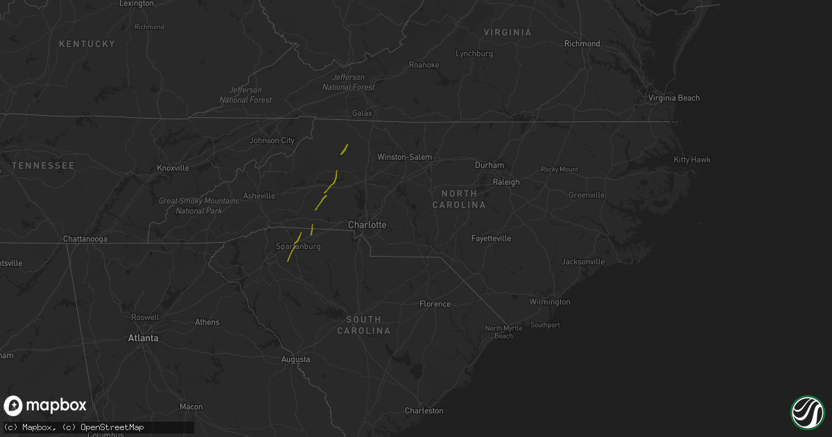
Hail Map in North Carolina on October 23, 2017
Get this storm
October 23 map
$229
one time, instant access
Download today. No call, no setup
Keep the $229
Bought the map and want the full workflow? Apply the entire $229 to a subscription within 7 days. None of it is wasted.
Every map, not just this one
This buys you this map. Subscription and you get every map we run, in the markets you choose from a few cities to whole states to nationwide. Plus real-time alerts the moment a storm fires.
Contact data
Name, contact info, occupancy, even credit band for addresses in the footprint. You go from where it hit to who to call.
Become the source they trust
Unlimited branding weather history reports on demand. You already have the documented answer ready for the property owner, and you are the one who showed up with it.
Property data and RoofTrace estimates
Pull up any address you have got, its value and the exact code rules for that jurisdiction, straight from One Click Code. Then RoofTrace estimates the squares, pitch, and roof value, priced the way you price.
Storm reports in North Carolina
North Carolina
| Date | Description |
|---|---|
| 10/23/20175:00 PM CDT | Tree down at highway 65 and goode road. |
| 10/23/20174:56 PM CDT | Tree down across woodfield dr. |
| 10/23/20174:55 PM CDT | Multiple trees blown down on backwoods ln and ed weaver rd. |
| 10/23/20174:50 PM CDT | A few trees blown down at tadpole trail and us hwy 64. |
| 10/23/20174:50 PM CDT | Multiple trees and power lines down across the town. |
| 10/23/20174:45 PM CDT | Many trees and powerlines down across the county particularly in pine ridge... Dobson... And mountain park. Possible microburst reported in pine ridge. |
| 10/23/20174:45 PM CDT | Thunderstorm winds downed two trees along jarvis road. |
| 10/23/20174:45 PM CDT | Large tree limbs down. |
| 10/23/20174:43 PM CDT | Strong thunderstorm winds downed several large trees and destroyed two barns and damaged another along glade valley road. |
| 10/23/20174:41 PM CDT | Thunderstorm winds damaged a mobile home along little prne road. |
| 10/23/20174:41 PM CDT | Thunderstorm winds uprooted and snapped several trees and damaged a barn along rector road. |
| 10/23/20174:35 PM CDT | Thunderstorm winds downed a tree at the intersection of wilson street and west main street. |
| 10/23/20174:35 PM CDT | Thunderstorm winds blew down a tree along shawtown road. |
| 10/23/20174:33 PM CDT | Thunderstorm winds damaged a barn located along barrett road. |
| 10/23/20174:29 PM CDT | Thunderstorm winds downed a tree along fall creek church road near jonesville. |
| 10/23/20174:24 PM CDT | A couple trees down near county line rd and hwy 901. |
| 10/23/20174:24 PM CDT | Significant tree damage and some structural damage to a home. |
| 10/23/20174:24 PM CDT | Multiple trees down on harmony hwy. |
| 10/23/20174:17 PM CDT | Several large limbs down. |
| 10/23/20174:17 PM CDT | Thunderstorm winds downed two large trees and a powerpole along little mountain church road. |
| 10/23/20174:15 PM CDT | A tree was blown down along old highway 60. |
| 10/23/20174:15 PM CDT | Possible tornado. Tree down on a house on glenn dancy road. Other trees and powerlines down nearby. |
| 10/23/20174:15 PM CDT | A tree was blown down onto a powerline near the community of wilkesboro. |
| 10/23/20174:11 PM CDT | A nws storm survey team has confirmed an ef1 tornado touched down in wilkesboro near the intersection of east main street and salem street at around 511 pm edt...remain |
| 10/23/20174:00 PM CDT | Thunderstorm winds downed a tree on a car within the community of moravian falls. |
| 10/23/20173:45 PM CDT | Trees down on icard ridge rd. |
| 10/23/20173:45 PM CDT | Numerous trees down on hwy 127 and heritage farm rd. |
| 10/23/20173:43 PM CDT | Roof off home at cathedral dr and addison ln. Numerous trees down and homes damaged in the neighborhood. |
| 10/23/20173:40 PM CDT | Public reported multiple trees snapped or uprooted. |
| 10/23/20173:40 PM CDT | Media reported many aircraft flipped and significant structural damage at the hickory airport. Possible tornado. |
| 10/23/20173:39 PM CDT | Trees down on george hildebran rd. |
| 10/23/20173:37 PM CDT | Mulitple structures damaged in hildebran. |
| 10/23/20173:35 PM CDT | Trees down on teague town rd. |
| 10/23/20173:35 PM CDT | Trees down on 127 and deerfield rd. |
| 10/23/20173:32 PM CDT | Trees down... One on a house south of hickory |
| 10/23/20173:31 PM CDT | Numerous trees down on hwy 221 by cliffside elementary school |
| 10/23/20173:31 PM CDT | Wall at hickory crawdads stadium sustained damage. |
| 10/23/20173:25 PM CDT | Trained spotter reported multiple houses with roof famage and numerous trees and power poles down along highway 10 in lincoln county. Possible tornado. |
| 10/23/20173:25 PM CDT | Tree down on home on summerow rd and mauney rd |
| 10/23/20173:20 PM CDT | Trees down and power outages on bridle path dr. |
| 10/23/20173:11 PM CDT | Trees and powerlines down on curt ledford rd and carpernters church rd. |
| 10/23/20173:05 PM CDT | Powerlines and trees down at hwy 10n and 7 pines rd |
| 10/23/20173:05 PM CDT | Tree down on a house on vic randall rd |
| 10/23/20173:04 PM CDT | Damage to a building on hwy 182 in lawndale. |
| 10/23/20173:03 PM CDT | Tree on a mobile home on deer track ln |
| 10/23/20173:03 PM CDT | Powerlines and large tree limbs down on west stage coach trail |
| 10/23/20172:56 PM CDT | Power lines down on metcalf rd near barbee rd. |
| 10/23/20172:45 PM CDT | Trees down... Some on homes. |
| 10/23/20172:42 PM CDT | Tree down on mccraw rd. |
| 10/23/20172:27 PM CDT | Tree blocking road by chesnee community fire department |
| 10/23/20172:15 PM CDT | Westerman st. At mill creek underwater |
| 10/23/20171:30 AM CDT | Spotter reported thunderstorm straight line wind damage on his property on jimmy smith road. 5 large trees were uprooted... The largest around 2 feet in diameter. One o |
| 10/23/201712:15 AM CDT | A local report indicates 58 MPH wind near FEDERAL POINT |
| 10/22/201710:45 PM CDT | Snapped trees along a path three-tenths of a mile long and 50 yards wide |
| 10/22/20179:16 PM CDT | Tree down in cerro gordo on main street. |
| 10/22/20179:15 PM CDT | Storage shed destroyed... Large tree limbs down... Trampoline thrown by the wind. |
| 10/22/20179:14 PM CDT | Large tree across talbot street and tree down on home on west columbus st. Other scattered limbs and tree damage across the city. |
| 10/22/20179:06 PM CDT | 2 trees blown down just north of old dothan road |


