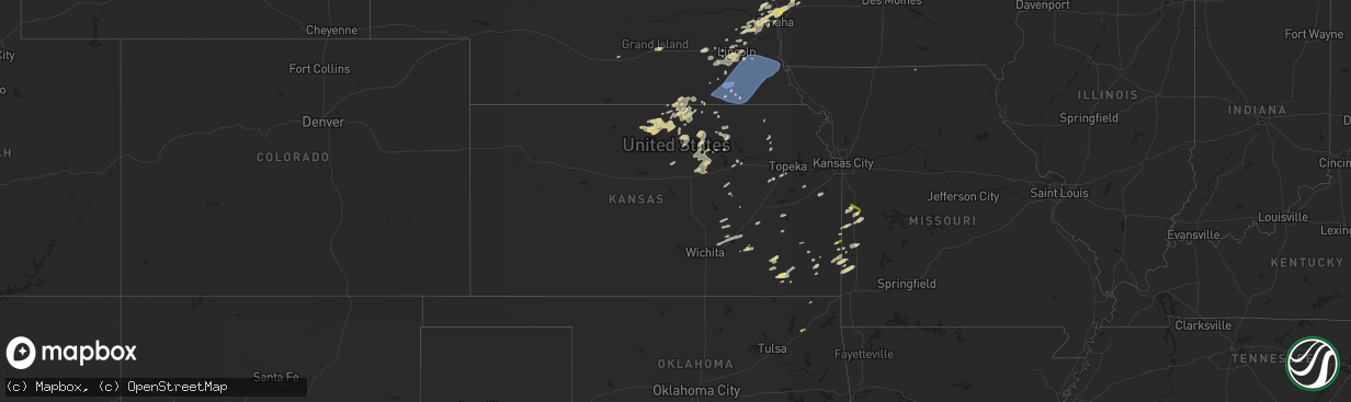
Hail Map in Kansas on October 11, 2022
The weather event in Kansas on October 11, 2022 includes Hail and Wind maps. 8 states and 281 cities were impacted and suffered possible damage. The total estimated number of properties impacted is 2,815.
Want more than just the map?
Turn this storm into a full workflow.
- Owner + property data so you know who to knock
- OnDemand branded weather history reports to win the "did we even have hail?" argument
- RoofTrace estimate so reps stop guessing numbers at the door
Bought this map? Upgrade within 7 days and we'll credit the $230. (10-15 min setup call)
Hail
Wind
2,815
Estimated number of impacted properties by a 1.00" hail or larger0
Estimated number of impacted properties by a 1.75" hail or larger0
Estimated number of impacted properties by a 2.50" hail or largerStorm reports in Kansas
Kansas
| Date | Description |
|---|---|
| 10/11/20226:43 AM CDT | At 1143 PM CDT, severe thunderstorms were located along a line extending from 3 miles north of Dunbar to 3 miles northwest of Liberty, moving east at 35 mph. HAZARD...70 mph wind gusts. SOURCE...Radar indicated. IMPACT...Expect considerable tree damage. Damage is likely to mobile homes, roofs, and outbuildings. Severe thunderstorms will be near... Nebraska City around 1200 AM CDT.Other locations in the path of these severe thunderstorms includeHamburg and Sidney.This includes Interstate 29 between mile markers 1 and 15. |
| 10/11/20226:30 AM CDT | At 1129 PM CDT, a severe thunderstorm was located near Glen Elder, or 12 miles northwest of Beloit, moving east at 35 mph. HAZARD...60 mph wind gusts and quarter size hail. SOURCE...Radar indicated. IMPACT...Hail damage to vehicles is expected. Expect wind damage to roofs, siding, and trees. Locations impacted include... Beloit, Glen Elder, Randall and Scottsville. |
| 10/11/20226:09 AM CDT | At 1109 PM CDT, severe thunderstorms were located along a line extending from 2 miles northwest of Palmyra to 3 miles northwest of Beatrice, moving east at 35 mph. HAZARD...70 mph wind gusts and penny size hail. SOURCE...Radar indicated. IMPACT...Expect considerable tree damage. Damage is likely to mobile homes, roofs, and outbuildings. Severe thunderstorms will be near... Palmyra around 1115 PM CDT. Unadilla around 1125 PM CDT.Other locations in the path of these severe thunderstorms includeSyracuse, Crab Orchard, Dunbar, Lewiston, Lorton, Burchard, PawneeCity, Table Rock and Elk Creek. |
| 10/11/20225:41 AM CDT | Quarter size hail in fort scott. |
All States Impacted by Hail Map on October 11, 2022
Cities Impacted by Hail Map on October 11, 2022
- Aitkin, MN
- Wymore, NE
- Havensville, KS
- Malcolm, NE
- Lincoln, NE
- Kimball, MN
- Watkins, MN
- Munden, KS
- Manhattan, KS
- Ogden, KS
- Beaver Crossing, NE
- Waco, NE
- Utica, NE
- Walnut, KS
- Chester, NE
- Hebron, NE
- Hubbell, NE
- Iola, KS
- Humboldt, KS
- Fredonia, KS
- Fall River, KS
- Barnard, KS
- Lincoln, KS
- Manilla, IA
- Kimballton, IA
- Irwin, IA
- Audubon, IA
- Manning, IA
- Harlan, IA
- Kirkman, IA
- Mindenmines, MO
- Hallam, NE
- Pleasant Dale, NE
- Crete, NE
- Denton, NE
- Dorchester, NE
- Martell, NE
- Roca, NE
- Eden Valley, MN
- Cold Spring, MN
- Grove City, MN
- Richmond, MN
- Shelby, IA
- Miltonvale, KS
- Concordia, KS
- Clyde, KS
- Clifton, KS
- Morganville, KS
- Clay Center, KS
- Burlington, KS
- Waverly, KS
- Fort Calhoun, NE
- Blair, NE
- Bennington, NE
- Beatrice, NE
- Annandale, MN
- South Haven, MN
- Tamarack, MN
- Kettle River, MN
- Coon Rapids, IA
- Kennard, NE
- Cherryvale, KS
- Independence, KS
- Harveyville, KS
- Benton, KS
- Towanda, KS
- El Dorado, KS
- Earling, IA
- Arlington, NE
- Janesville, MN
- Pemberton, MN
- Kearney, NE
- Palmer, KS
- Cokato, MN
- Waverly, NE
- Gretna, NE
- Jamestown, KS
- Fort Scott, KS
- Garland, KS
- Defiance, IA
- Madison, KS
- Garland, NE
- Raymond, NE
- Republic, KS
- Neodesha, KS
- Elk City, KS
- Bennet, NE
- Spooner, WI
- Sarona, WI
- Richland Center, WI
- Hillsboro, WI
- Palmyra, NE
- Floodwood, MN
- Bronaugh, MO
- Franklin, KS
- Liberal, MO
- Pittsburg, KS
- Mulberry, KS
- Good Thunder, MN
- Orr, MN
- Burns, KS
- Riley, KS
- Paynesville, MN
- New London, MN
- Spicer, MN
- Atwater, MN
- Phillips, NE
- Doniphan, NE
- Aurora, NE
- Giltner, NE
- Grand Island, NE
- Elkhorn, NE
- Persia, IA
- Panama, IA
- Missouri Valley, IA
- Underwood, IA
- Omaha, NE
- Yutan, NE
- Memphis, NE
- Ashland, NE
- Wahoo, NE
- Portsmouth, IA
- Mead, NE
- Ceresco, NE
- Crescent, IA
- Ithaca, NE
- Neola, IA
- Honey Creek, IA
- Minden, IA
- Logan, IA
- Boys Town, NE
- Waterloo, NE
- Parsons, KS
- McCune, KS
- Amana, IA
- Homestead, IA
- Swanton, NE
- Davey, NE
- Ogden, IA
- Mankato, KS
- Epworth, IA
- Mahaska, KS
- Greenleaf, KS
- Barnes, KS
- Herington, KS
- Leon, KS
- Saint Paul, KS
- Erie, KS
- Glen Elder, KS
- Cawker City, KS
- Jewell, KS
- Esbon, KS
- Portis, KS
- Downs, KS
- Randall, KS
- Thayer, KS
- Nevada, MO
- Diller, NE
- Morrowville, KS
- Washington, KS
- Fort Riley, KS
- Junction City, KS
- Paola, KS
- Rantoul, KS
- Wellsville, KS
- Eureka, KS
- Maple Lake, MN
- Buffalo, MN
- Monticello, MN
- Milford, NE
- Wilber, NE
- La Vista, NE
- Papillion, NE
- Iron Belt, WI
- Cumberland, WI
- Rice Lake, WI
- Wright, MN
- Unionville, MO
- Willmar, MN
- Arma, KS
- Girard, KS
- Arcadia, KS
- Solomon, KS
- Salina, KS
- New Cambria, KS
- Minneapolis, KS
- Abilene, KS
- Longford, KS
- Piedmont, KS
- Emmett, KS
- Saint Marys, KS
- Ottawa, KS
- Florence, KS
- Peabody, KS
- Eskridge, KS
- Longton, KS
- Burdick, KS
- Daykin, NE
- Randolph, KS
- Green, KS
- Courtland, KS
- Adrian, MO
- Butler, MO
- Cook, MN
- Scandia, KS
- Rich Hill, MO
- Prescott, KS
- Hume, MO
- Yates Center, KS
- Glasco, KS
- Seward, NE
- York, AL
- Pennington, AL
- Elmdale, KS
- Amsterdam, MO
- Amoret, MO
- Belleville, KS
- Weston, NE
- Webber, KS
- Deshler, NE
- Formoso, KS
- Hardy, NE
- Byron, NE
- Ruskin, NE
- Centralia, KS
- Narka, KS
- Oronogo, MO
- Lamar, MO
- Asbury, MO
- Council Bluffs, IA
- Wakarusa, KS
- Auburn, KS
- Welch, OK
- Lake Nebagamon, WI
- Gaylord, KS
- Blue Springs, NE
- Moundville, MO
- Leonardville, KS
- Lake Lillian, MN
- Friend, NE
- Chelsea, OK
- Deweese, NE
- Adair, OK
- Cook, NE
- Sterling, NE
- Unadilla, NE
- Johnson, NE
- Clatonia, NE
- Syracuse, NE
- Lewiston, NE
- Douglas, NE
- Crab Orchard, NE
- Virginia, NE
- Steele City, NE
- Hickman, NE
- Eagle, NE
- Otoe, NE
- Jansen, NE
- Panama, NE
- Brock, NE
- Firth, NE
- Plymouth, NE
- Walton, NE
- Liberty, NE
- Nebraska City, NE
- Barneston, NE
- Lorton, NE
- De Witt, NE
- Burr, NE
- Julian, NE
- Talmage, NE
- Filley, NE
- Burchard, NE
- Adams, NE
- Odell, NE
- Dunbar, NE
- Tecumseh, NE
- Pickrell, NE
- Fairbury, NE
- Steinauer, NE
- Cortland, NE


