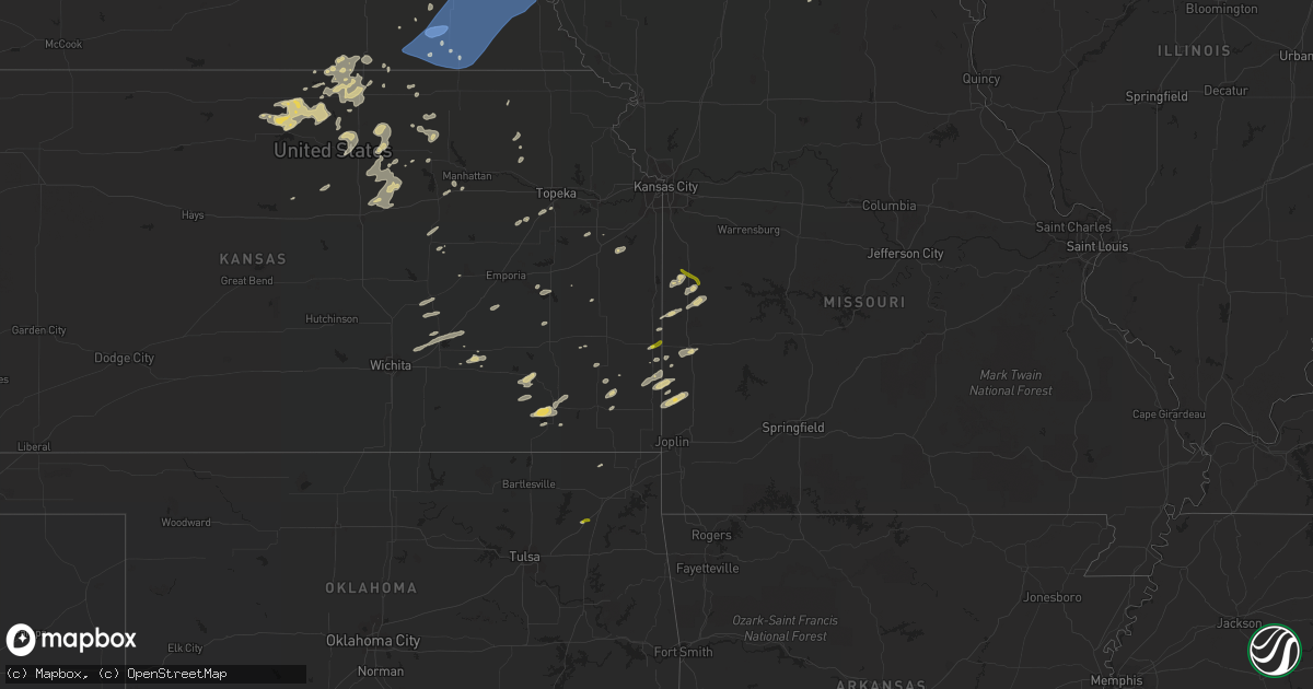
Hail Map on October 11, 2022
Get this storm
October 11 map
$229
one time, instant access
Download today. No call, no setup
Keep the $229
Bought the map and want the full workflow? Apply the entire $229 to a subscription within 7 days. None of it is wasted.
Every map, not just this one
This buys you this map. Subscription and you get every map we run, in the markets you choose from a few cities to whole states to nationwide. Plus real-time alerts the moment a storm fires.
Contact data
Name, contact info, occupancy, even credit band for addresses in the footprint. You go from where it hit to who to call.
Become the source they trust
Unlimited branding weather history reports on demand. You already have the documented answer ready for the property owner, and you are the one who showed up with it.
Property data and RoofTrace estimates
Pull up any address you have got, its value and the exact code rules for that jurisdiction, straight from One Click Code. Then RoofTrace estimates the squares, pitch, and roof value, priced the way you price.
States Impacted by Hail Map on October 11, 2022
Storm reports
Kansas
| Date | Description |
|---|---|
| 10/11/20226:43 AM CDT | At 1143 PM CDT, severe thunderstorms were located along a line extending from 3 miles north of Dunbar to 3 miles northwest of Liberty, moving east at 35 mph. HAZARD...70 mph wind gusts. SOURCE...Radar indicated. IMPACT...Expect considerable tree damage. Damage is likely to mobile homes, roofs, and outbuildings. Severe thunderstorms will be near... Nebraska City around 1200 AM CDT.Other locations in the path of these severe thunderstorms includeHamburg and Sidney.This includes Interstate 29 between mile markers 1 and 15. |
| 10/11/20226:30 AM CDT | At 1129 PM CDT, a severe thunderstorm was located near Glen Elder, or 12 miles northwest of Beloit, moving east at 35 mph. HAZARD...60 mph wind gusts and quarter size hail. SOURCE...Radar indicated. IMPACT...Hail damage to vehicles is expected. Expect wind damage to roofs, siding, and trees. Locations impacted include... Beloit, Glen Elder, Randall and Scottsville. |
| 10/11/20226:09 AM CDT | At 1109 PM CDT, severe thunderstorms were located along a line extending from 2 miles northwest of Palmyra to 3 miles northwest of Beatrice, moving east at 35 mph. HAZARD...70 mph wind gusts and penny size hail. SOURCE...Radar indicated. IMPACT...Expect considerable tree damage. Damage is likely to mobile homes, roofs, and outbuildings. Severe thunderstorms will be near... Palmyra around 1115 PM CDT. Unadilla around 1125 PM CDT.Other locations in the path of these severe thunderstorms includeSyracuse, Crab Orchard, Dunbar, Lewiston, Lorton, Burchard, PawneeCity, Table Rock and Elk Creek. |
| 10/11/20225:41 AM CDT | Quarter size hail in fort scott. |
Nebraska
| Date | Description |
|---|---|
| 10/11/20226:24 AM CDT | At 1124 PM CDT, severe thunderstorms were located along a line extending from 3 miles east of Bennet to 3 miles south of Diller, moving east at 30 mph. HAZARD...60 mph wind gusts. SOURCE...Radar indicated. IMPACT...Expect damage to roofs, siding, and trees. Severe thunderstorms will be near... Bennet and Panama around 1130 PM CDT.Other locations in the path of these severe thunderstorms includeBarneston. |
| 10/11/20225:48 AM CDT | At 1048 PM CDT, severe thunderstorms were located along a line extending from 3 miles north of Wilber to 3 miles southeast of Reynolds, moving east at 40 mph. HAZARD...70 mph wind gusts. SOURCE...Radar indicated. IMPACT...Expect considerable tree damage. Damage is likely to mobile homes, roofs, and outbuildings. Severe thunderstorms will be near... Crete and Wilber around 1055 PM CDT. Clatonia around 1100 PM CDT. Hallam around 1105 PM CDT.Other locations in the path of these severe thunderstorms includeCortland, Sprague, Steele City, Hickman, Firth, Diller, Panama, Adamsand Odell. |
| 10/11/20224:55 AM CDT | At 955 PM CDT, a severe thunderstorm was located 3 miles northwest of Goehner, or 9 miles west of Seward, moving northeast at 40 mph. HAZARD...60 mph wind gusts and quarter size hail. SOURCE...Radar indicated. IMPACT...Hail damage to vehicles is expected. Expect wind damage to roofs, siding, and trees. This severe thunderstorm will be near... Seward and Staplehurst around 1010 PM CDT. Bee around 1015 PM CDT.Other locations in the path of this severe thunderstorm includeGarland and Malcolm.This includes Interstate 80 in Nebraska between mile markers 366 and388. |
| 10/10/202211:40 PM CDT | Time estimated based on radar. Walls blown out on a machine shed. |
| 10/10/202211:32 PM CDT | A local report indicates 68 MPH wind near LEWISTON |
| 10/10/202211:16 PM CDT | A local report indicates 66 MPH wind near 4 S ELMWOOD |
| 10/10/202211:15 PM CDT | A local report indicates 65 MPH wind near 2 NW FIRTH |
| 10/10/202211:11 PM CDT | A local report indicates 59 MPH wind near 2 N BEATRICE |
| 10/10/202211:00 PM CDT | A local report indicates 87 MPH wind near 2 E PLYMOUTH |
| 10/10/202210:58 PM CDT | A local report indicates 58 MPH wind near ROCA |
| 10/10/202210:57 PM CDT | A local report indicates 70 MPH wind near CRETE |
Iowa
| Date | Description |
|---|---|
| 10/11/20226:22 AM CDT | At 1121 PM CDT, a severe thunderstorm was located 5 miles northeast of Crescent, or 13 miles north of Council Bluffs, moving east at 20 mph. HAZARD...60 mph wind gusts and quarter size hail. SOURCE...Radar indicated. IMPACT...Hail damage to vehicles is expected. Expect wind damage to roofs, siding, and trees. This severe thunderstorm will be near... Underwood around 1140 PM CDT.Other locations in the path of this severe thunderstorm include Neolaand Minden.This includes Interstate 80 in Iowa between mile markers 14 and 31. |
Missouri
| Date | Description |
|---|---|
| 10/11/20225:15 AM CDT | Hail from the size of peas to the size of quarters. |
Minnesota
| Date | Description |
|---|---|
| 10/11/20223:38 AM CDT | At 837 PM CDT, a severe thunderstorm was located near Orr, or 18 miles northwest of Lake Vermilion, moving northeast at 40 mph. HAZARD...Golf ball size hail. SOURCE...A trained weather spotter reported golfball size hail near Gheen at 8:35 PM. IMPACT...People and animals outdoors will be injured. Expect damage to roofs, siding, windows, and vehicles. This severe thunderstorm will be near... Buyck around 850 PM CDT.Other locations in the path of this severe thunderstorm include CraneLake. |
| 10/10/20228:38 PM CDT | A local report indicates 1.75 inch wind near 1 N GHEEN |
Oklahoma
| Date | Description |
|---|---|
| 10/11/20226:57 AM CDT | Social media report with accompanying of 1 inch hail near highway 28 and i-44. |
Cities Impacted by Hail Map on October 11, 2022
- Aitkin, MN
- Wymore, NE
- Havensville, KS
- Malcolm, NE
- Lincoln, NE
- Kimball, MN
- Watkins, MN
- Munden, KS
- Manhattan, KS
- Ogden, KS
- Beaver Crossing, NE
- Waco, NE
- Utica, NE
- Walnut, KS
- Chester, NE
- Hebron, NE
- Hubbell, NE
- Iola, KS
- Humboldt, KS
- Fredonia, KS
- Fall River, KS
- Barnard, KS
- Lincoln, KS
- Manilla, IA
- Kimballton, IA
- Irwin, IA
- Audubon, IA
- Manning, IA
- Harlan, IA
- Kirkman, IA
- Mindenmines, MO
- Hallam, NE
- Pleasant Dale, NE
- Crete, NE
- Denton, NE
- Dorchester, NE
- Martell, NE
- Roca, NE
- Eden Valley, MN
- Cold Spring, MN
- Grove City, MN
- Richmond, MN
- Shelby, IA
- Miltonvale, KS
- Concordia, KS
- Clyde, KS
- Clifton, KS
- Morganville, KS
- Clay Center, KS
- Burlington, KS
- Waverly, KS
- Fort Calhoun, NE
- Blair, NE
- Bennington, NE
- Beatrice, NE
- Annandale, MN
- South Haven, MN
- Tamarack, MN
- Kettle River, MN
- Coon Rapids, IA
- Kennard, NE
- Cherryvale, KS
- Independence, KS
- Harveyville, KS
- Benton, KS
- Towanda, KS
- El Dorado, KS
- Earling, IA
- Arlington, NE
- Janesville, MN
- Pemberton, MN
- Kearney, NE
- Palmer, KS
- Cokato, MN
- Waverly, NE
- Gretna, NE
- Jamestown, KS
- Fort Scott, KS
- Garland, KS
- Defiance, IA
- Madison, KS
- Garland, NE
- Raymond, NE
- Republic, KS
- Neodesha, KS
- Elk City, KS
- Bennet, NE
- Spooner, WI
- Sarona, WI
- Richland Center, WI
- Hillsboro, WI
- Palmyra, NE
- Floodwood, MN
- Bronaugh, MO
- Franklin, KS
- Liberal, MO
- Pittsburg, KS
- Mulberry, KS
- Good Thunder, MN
- Orr, MN
- Burns, KS
- Riley, KS
- Paynesville, MN
- New London, MN
- Spicer, MN
- Atwater, MN
- Phillips, NE
- Doniphan, NE
- Aurora, NE
- Giltner, NE
- Grand Island, NE
- Elkhorn, NE
- Persia, IA
- Panama, IA
- Missouri Valley, IA
- Underwood, IA
- Omaha, NE
- Yutan, NE
- Memphis, NE
- Ashland, NE
- Wahoo, NE
- Portsmouth, IA
- Mead, NE
- Ceresco, NE
- Crescent, IA
- Ithaca, NE
- Neola, IA
- Honey Creek, IA
- Minden, IA
- Logan, IA
- Boys Town, NE
- Waterloo, NE
- Parsons, KS
- McCune, KS
- Amana, IA
- Homestead, IA
- Swanton, NE
- Davey, NE
- Ogden, IA
- Mankato, KS
- Epworth, IA
- Mahaska, KS
- Greenleaf, KS
- Barnes, KS
- Herington, KS
- Leon, KS
- Saint Paul, KS
- Erie, KS
- Glen Elder, KS
- Cawker City, KS
- Jewell, KS
- Esbon, KS
- Portis, KS
- Downs, KS
- Randall, KS
- Thayer, KS
- Nevada, MO
- Diller, NE
- Morrowville, KS
- Washington, KS
- Fort Riley, KS
- Junction City, KS
- Paola, KS
- Rantoul, KS
- Wellsville, KS
- Eureka, KS
- Maple Lake, MN
- Buffalo, MN
- Monticello, MN
- Milford, NE
- Wilber, NE
- La Vista, NE
- Papillion, NE
- Iron Belt, WI
- Cumberland, WI
- Rice Lake, WI
- Wright, MN
- Unionville, MO
- Willmar, MN
- Arma, KS
- Girard, KS
- Arcadia, KS
- Solomon, KS
- Salina, KS
- New Cambria, KS
- Minneapolis, KS
- Abilene, KS
- Longford, KS
- Piedmont, KS
- Emmett, KS
- Saint Marys, KS
- Ottawa, KS
- Florence, KS
- Peabody, KS
- Eskridge, KS
- Longton, KS
- Burdick, KS
- Daykin, NE
- Randolph, KS
- Green, KS
- Courtland, KS
- Adrian, MO
- Butler, MO
- Cook, MN
- Scandia, KS
- Rich Hill, MO
- Prescott, KS
- Hume, MO
- Yates Center, KS
- Glasco, KS
- Seward, NE
- York, AL
- Pennington, AL
- Elmdale, KS
- Amsterdam, MO
- Amoret, MO
- Belleville, KS
- Weston, NE
- Webber, KS
- Deshler, NE
- Formoso, KS
- Hardy, NE
- Byron, NE
- Ruskin, NE
- Centralia, KS
- Narka, KS
- Oronogo, MO
- Lamar, MO
- Asbury, MO
- Council Bluffs, IA
- Wakarusa, KS
- Auburn, KS
- Welch, OK
- Lake Nebagamon, WI
- Gaylord, KS
- Blue Springs, NE
- Moundville, MO
- Leonardville, KS
- Lake Lillian, MN
- Friend, NE
- Chelsea, OK
- Deweese, NE
- Adair, OK
- Cook, NE
- Sterling, NE
- Unadilla, NE
- Johnson, NE
- Clatonia, NE
- Syracuse, NE
- Lewiston, NE
- Douglas, NE
- Crab Orchard, NE
- Virginia, NE
- Steele City, NE
- Hickman, NE
- Eagle, NE
- Otoe, NE
- Jansen, NE
- Panama, NE
- Brock, NE
- Firth, NE
- Plymouth, NE
- Walton, NE
- Liberty, NE
- Nebraska City, NE
- Barneston, NE
- Lorton, NE
- De Witt, NE
- Burr, NE
- Julian, NE
- Talmage, NE
- Filley, NE
- Burchard, NE
- Adams, NE
- Odell, NE
- Dunbar, NE
- Tecumseh, NE
- Pickrell, NE
- Fairbury, NE
- Steinauer, NE
- Cortland, NE