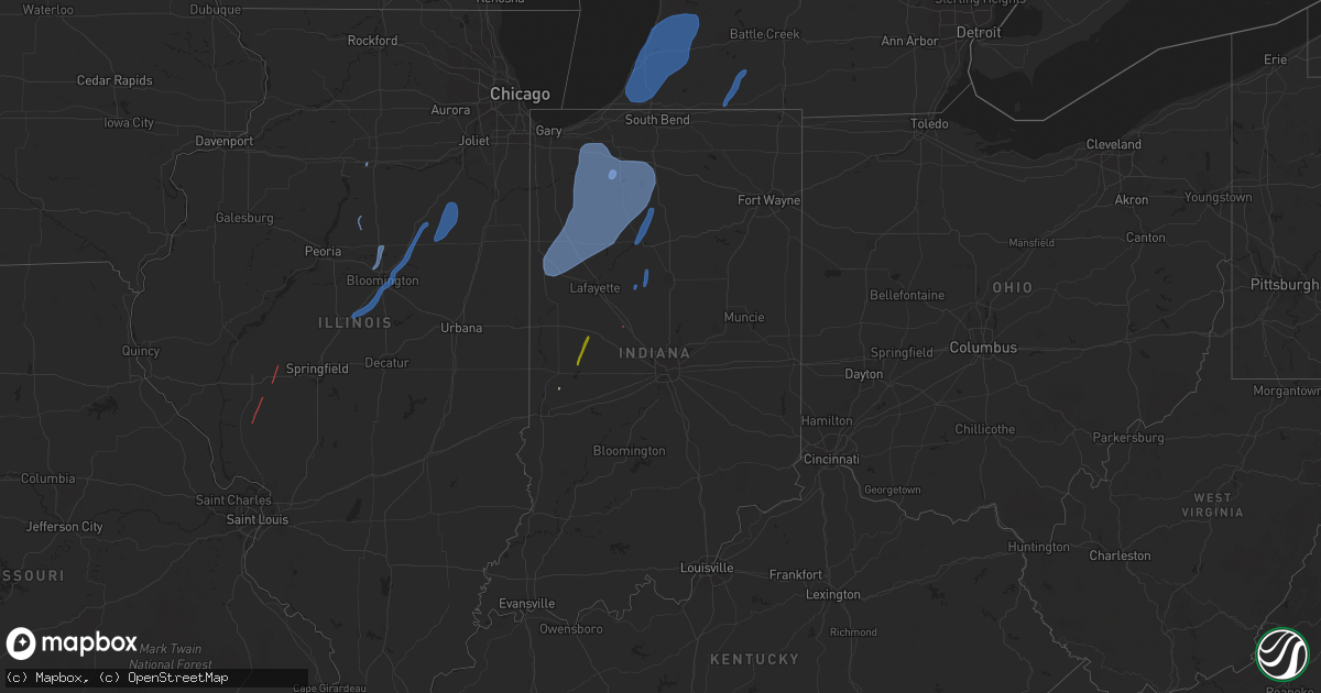
Hail Map in Indiana on October 11, 2021
Get this storm
October 11 map
$229
one time, instant access
Download today. No call, no setup
Keep the $229
Bought the map and want the full workflow? Apply the entire $229 to a subscription within 7 days. None of it is wasted.
Every map, not just this one
This buys you this map. Subscription and you get every map we run, in the markets you choose from a few cities to whole states to nationwide. Plus real-time alerts the moment a storm fires.
Contact data
Name, contact info, occupancy, even credit band for addresses in the footprint. You go from where it hit to who to call.
Become the source they trust
Unlimited branding weather history reports on demand. You already have the documented answer ready for the property owner, and you are the one who showed up with it.
Property data and RoofTrace estimates
Pull up any address you have got, its value and the exact code rules for that jurisdiction, straight from One Click Code. Then RoofTrace estimates the squares, pitch, and roof value, priced the way you price.
Storm reports in Indiana
Indiana
| Date | Description |
|---|---|
| 10/11/20216:47 PM CDT | Tree down. |
| 10/11/20216:11 PM CDT | Large branch over roadway. |
| 10/11/20216:10 PM CDT | St. Joseph co fire reports trees down. |
| 10/11/20216:10 PM CDT | St. Joseph co fire reports trees down. |
| 10/11/20216:10 PM CDT | St. Joseph co fire reports trees down. |
| 10/11/20216:05 PM CDT | Large branches down. |
| 10/11/20216:01 PM CDT | Picture shared on twitter of large tree limb blown off bottom of a tree. Rot visible. |
| 10/11/20216:00 PM CDT | Pine tree blown down. Time estimated. |
| 10/11/20215:35 PM CDT | Asos station kvpz valparaiso airport. |
| 10/11/20215:23 PM CDT | Report via spotter network of 74.6mph winds. |
| 10/11/20215:13 PM CDT | Large tree down blocking highway 10. |
| 10/11/20215:08 PM CDT | Tree damage along the white and carroll county line. There was some additional tree damage slightly to the east. Delayed report from yesterday with time estimated from |
| 10/11/20214:54 PM CDT | A local report indicates 64 MPH wind near 2 WSW LAKE CICOTT |
| 10/11/20214:49 PM CDT | Late report of approximate 10 inch diameter limb broken from tree at intersection of old state road 25 and county road 500 north. |
| 10/11/20214:46 PM CDT | Mesonet station in048 1.7 e remington |
| 10/11/20214:42 PM CDT | Semi blown over just east of wolcott on us24. Relayed by wlfi. Time estimated by radar. |
| 10/11/20214:42 PM CDT | Trained spotter reports large tree estimated 3-4 foot diameter blown down. |
| 10/11/20214:34 PM CDT | Trees downed across dayton. |
| 10/11/20214:28 PM CDT | Late report of a 24 foot by 20 foot structure flattened on south kerkhoff avenue. Time estimated from radar. |
| 10/11/20214:26 PM CDT | At wlfi. |
| 10/11/20214:25 PM CDT | Reports of numerous tree limbs blown down by thunderstorm winds along south newman road were received. Time estimated via asos max wind gust report. |
| 10/11/20214:23 PM CDT | Several reports of large limbs down. Time is estimated from radar. |
| 10/11/20214:07 PM CDT | There are at least two homes damaged with trees down. |
| 10/11/20214:07 PM CDT | Large trees and limbs down in attica. Some are blocking streets. Time is approximated from radar velocity couplet. |
| 10/11/20214:07 PM CDT | Report of roof damage to attica high school from storm wind. Water damage to principles office. |
| 10/11/20214:04 PM CDT | Corrects previous tstm wnd gst report from 1 ese rockville. Recorded from personal weather station of a spotter... Relayed by broadcast media. |
| 10/11/20213:48 PM CDT | A report of a 50 to 60 foot tree blown down from thunderstorm winds was received. Location and time is approximate. |
| 10/11/20215:04 AM CDT | At 1003 PM EDT, a severe thunderstorm was located near Culver, or 9 miles northwest of Rochester, moving northeast at 55 mph. HAZARD...60 mph wind gusts. SOURCE...Radar indicated. IMPACT...Expect damage to roofs, siding, and trees. Locations impacted include... Plymouth, Bremen, Bourbon, Argos, Culver, Koontz Lake, Walnut, Tippecanoe, La Paz, Twin Lakes, Inwood, Teegarden, Rutland, Burr Oak, Maxinkuckee, Tyner, Hibbard, Old Tip Town, Donaldson and Linkville. |
| 10/11/20214:52 AM CDT | At 950 PM EDT, a severe thunderstorm was located 11 miles west of Kokomo, moving northeast at 55 mph. HAZARD...60 mph wind gusts. SOURCE...Radar indicated. IMPACT...Expect damage to roofs, siding, and trees. Locations impacted include... Peru, Grissom Afb, Walton, Bunker Hill, Mexico, Lincoln, Wells, Galveston, Erie, Denver, Macy, Onward, Chili, Deacon, New Waverly, Deedsville, Hoover, Gilead, Nead and Anoka. |
| 10/11/20214:44 AM CDT | At 944 PM EDT, a severe thunderstorm was located near Logansport, moving northeast at 55 mph. HAZARD...60 mph wind gusts. SOURCE...Radar indicated. IMPACT...Expect damage to roofs, siding, and trees. Locations impacted include... Logansport, Rochester, Royal Center, Kewanna, Fulton, Leiters Ford, Nyena Lake, Leases Corner, Athens, Twelve Mile, Bruce Lake Station, Metea, Grass Creek, Delong, Tiosa, Fletcher, Lake Manitou, Adamsboro, Lucerne and Marshtown. |
| 10/11/20214:30 AM CDT | At 930 PM EDT, a severe thunderstorm was located 8 miles east of Delphi, or 13 miles southwest of Logansport, moving north at 60 mph. HAZARD...60 mph wind gusts. SOURCE...Radar indicated. IMPACT...Expect damage to roofs, siding, and trees. This severe thunderstorm will remain over mainly rural areas of eastern Carroll County. |
| 10/11/20214:10 AM CDT | At 910 PM EDT, a line of showers was located 10 miles southwest of Frankfort, moving north at 35 mph. A weak tornado is possible along this short line. HAZARD...60 mph wind gusts. SOURCE...Radar indicated. IMPACT...Expect damage to roofs, siding, and trees. This severe thunderstorm will be near... Frankfort around 925 PM EDT. Mulberry around 930 PM EDT.Other locations in the path of this severe thunderstorm includeRossville.This includes Interstate 65 between mile markers 146 and 158. |
| 10/11/20211:29 AM CDT | At 628 PM EDT/528 PM CDT/, a severe thunderstorm was located near Koontz Lake, or 8 miles northeast of Knox, moving northeast at 60 mph. HAZARD...70 mph wind gusts. SOURCE...Public. IMPACT...Expect considerable tree damage. Damage is likely to mobile homes, roofs, and outbuildings. Locations impacted include... South Bend, Mishawaka, Michigan City, La Porte, Plymouth, Westville, Bremen, Knox, Georgetown, Trail Creek, Gulivoire Park, Granger, Osceola, Walkerton, North Liberty, New Carlisle, Argos, Kingsford Heights, Culver and Long Beach.This includes the following highways... Interstate 80 in Indiana between mile markers 38 and 86. Interstate 94 in Indiana between mile markers 33 and 45. Interstate 94 in Michigan near mile marker 0. |
| 10/11/202112:52 AM CDT | At 552 PM EDT/452 PM CDT/, severe thunderstorms were located along a line extending from near Monticello to near Delphi to 11 miles northeast of Frankfort, moving north at 65 mph. HAZARD...60 mph wind gusts and quarter size hail. SOURCE...Radar indicated. IMPACT...Hail damage to vehicles is expected. Expect wind damage to roofs, siding, and trees. Locations impacted include... Logansport, Rochester, Monticello, Winamac, Akron, Walton, Royal Center, Mexico, Lincoln, Pulaski, Ripley, Kewanna, Burnettsville, Fulton, Monterey, Macy, Onward, Clymers, Beardstown and Nyena Lake. |
| 10/11/202112:44 AM CDT | At 544 PM EDT, a severe thunderstorm was located 8 miles southwest of Delphi, or 8 miles northeast of Lafayette, moving northeast at 60 mph. HAZARD...60 mph wind gusts and nickel size hail. SOURCE...Radar indicated. IMPACT...Expect damage to roofs, siding, and trees. This severe thunderstorm will be near... Delphi, Flora, Camden and Yeoman around 555 PM EDT.This includes Interstate 65 between mile markers 176 and 184. |
| 10/11/202112:23 AM CDT | At 523 PM EDT, a severe thunderstorm was located near Crawfordsville, moving northeast at 60 mph. HAZARD...60 mph wind gusts and quarter size hail. SOURCE...Trained weather spotters. IMPACT...Hail damage to vehicles is expected. Expect wind damage to roofs, siding, and trees. This severe thunderstorm will be near... Linden and New Richmond around 535 PM EDT.Other locations in the path of this severe thunderstorm includeDayton.This includes the following highways... Interstate 65 between mile markers 162 and 178. Interstate 74 between mile markers 26 and 37. |
| 10/10/202111:52 PM CDT | At 452 PM EDT, a severe thunderstorm was located near Rockville, or 17 miles north of Terre Haute, moving northeast at 60 mph. HAZARD...60 mph wind gusts. SOURCE...Radar indicated. IMPACT...Expect damage to roofs, siding, and trees. This severe thunderstorm will be near... Rockville and Bloomingdale around 500 PM EDT. Marshall, Turkey Run State Park and Judson around 505 PM EDT. Waveland around 510 PM EDT.Other locations in the path of this severe thunderstorm includeWaynetown, Wallace, Alamo and Shades State Park.This includes Interstate 74 between mile markers 21 and 39. |
| 10/10/202111:50 PM CDT | At 449 PM CDT, severe thunderstorms were located along a line extending from 8 miles northwest of Rensselaer to near Hanging Grove, moving north at 50 mph. HAZARD...60 mph wind gusts. SOURCE...Radar indicated. IMPACT...Expect damage to roofs, siding, and trees. Locations impacted include... Portage, Valparaiso, Chesterton, Rensselaer, DeMotte, Hebron, Wheatfield, Lakes of the Four Seasons, South Haven, Porter, Roselawn, Kouts, Burns Harbor, Ogden Dunes, Town of Pines, Beverly Shores, Hanging Grove, Wheeler, Collegeville and Dune Acres.This includes... Valparaiso University, Indiana Dunes State Park,and Porter County Fairgrounds. |
| 10/10/20218:40 PM CDT | 10 trees downed across the eastern portions of the county with no specific location noted. Delayed report with time and location estimated from radar. |
| 10/10/20218:24 PM CDT | 1 tree downed with several large tree limbs also downed within the city limits. Delayed report and time estimated from radar. |
All States Impacted by Hail Map on October 11, 2021
Cities Impacted by Hail Map on October 11, 2021
- Rosedale, IN
- Campo, CA
- Boulevard, CA
- Pine Valley, CA
- Calipatria, CA
- Brawley, CA
- Thermal, CA
- Ocotillo, CA
- Westmorland, CA
- Brookston, IN
- Royal Center, IN
- Union Mills, IN
- Kouts, IN
- Kewanna, IN
- La Crosse, IN
- Grovertown, IN
- West Lafayette, IN
- Monterey, IN
- Francesville, IN
- Medaryville, IN
- San Pierre, IN
- Otterbein, IN
- Monon, IN
- Ora, IN
- Monticello, IN
- Boswell, IN
- Fowler, IN
- Winamac, IN
- Goodland, IN
- Chalmers, IN
- Rensselaer, IN
- Burnettsville, IN
- Buffalo, IN
- Westville, IN
- Reynolds, IN
- Culver, IN
- Remington, IN
- Argos, IN
- Idaville, IN
- Hanna, IN
- Oxford, IN
- Wheatfield, IN
- Knox, IN
- North Judson, IN
- Rochester, IN
- Valparaiso, IN
- Plymouth, IN
- Star City, IN
- Hamlet, IN
- Wanatah, IN
- Wolcott, IN
- Earl Park, IN
- Thorntown, IN
- Frankfort, IN
- Flora, IN
- Cutler, IN
- Kokomo, IN
- Russiaville, IN
- Bringhurst, IN
- Logansport, IN
- Lucerne, IN
- Jacksonville, IL
- Franklin, IL
- Alexander, IL
- White Hall, IL
- Wrights, IL
- Roodhouse, IL
- Murrayville, IL
- Greenfield, IL
- Pontiac, IL
- Heyworth, IL
- Shirley, IL
- Normal, IL
- Waynesville, IL
- Lexington, IL
- Chenoa, IL
- Atlanta, IL
- Bloomington, IL
- McLean, IL
- Towanda, IL
- Lincoln, IL
- Roanoke, IL
- Washburn, IL
- Toluca, IL
- Carlock, IL
- El Paso, IL
- Hudson, IL
- Cullom, IL
- Cabery, IL
- Reddick, IL
- Forrest, IL
- Dwight, IL
- Saunemin, IL
- Buckingham, IL
- Emington, IL
- Campus, IL
- Kempton, IL
- Fairbury, IL
- Peru, IL
- Rockville, IN
- Crawfordsville, IN
- Waveland, IN
- Dowagiac, MI
- Three Oaks, MI
- New Troy, MI
- Hartford, MI
- Galien, MI
- Lawrence, MI
- Baroda, MI
- Buchanan, MI
- Sawyer, MI
- Stevensville, MI
- Covert, MI
- Niles, MI
- Coloma, MI
- Allegan, MI
- Saint Joseph, MI
- Berrien Center, MI
- Watervliet, MI
- Bangor, MI
- Gobles, MI
- Bloomingdale, MI
- Grand Junction, MI
- Pullman, MI
- Eau Claire, MI
- Sodus, MI
- Paw Paw, MI
- South Haven, MI
- Berrien Springs, MI
- Bridgman, MI
- Benton Harbor, MI
- Decatur, MI
- Grand Rapids, MI
- Byron Center, MI
- Dorr, MI
- Wayland, MI
- Mendon, MI
- White Pigeon, MI
- Constantine, MI
- Centreville, MI
- Sturgis, MI
- Leonidas, MI


