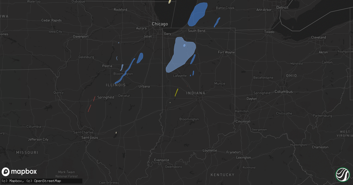
Hail Map on October 11, 2021
Get this storm
October 11 map
$229
one time, instant access
Download today. No call, no setup
Keep the $229
Bought the map and want the full workflow? Apply the entire $229 to a subscription within 7 days. None of it is wasted.
Every map, not just this one
This buys you this map. Subscription and you get every map we run, in the markets you choose from a few cities to whole states to nationwide. Plus real-time alerts the moment a storm fires.
Contact data
Name, contact info, occupancy, even credit band for addresses in the footprint. You go from where it hit to who to call.
Become the source they trust
Unlimited branding weather history reports on demand. You already have the documented answer ready for the property owner, and you are the one who showed up with it.
Property data and RoofTrace estimates
Pull up any address you have got, its value and the exact code rules for that jurisdiction, straight from One Click Code. Then RoofTrace estimates the squares, pitch, and roof value, priced the way you price.
States Impacted by Hail Map on October 11, 2021
Storm reports
Indiana
| Date | Description |
|---|---|
| 10/11/20216:47 PM CDT | Tree down. |
| 10/11/20216:11 PM CDT | Large branch over roadway. |
| 10/11/20216:10 PM CDT | St. Joseph co fire reports trees down. |
| 10/11/20216:10 PM CDT | St. Joseph co fire reports trees down. |
| 10/11/20216:10 PM CDT | St. Joseph co fire reports trees down. |
| 10/11/20216:05 PM CDT | Large branches down. |
| 10/11/20216:01 PM CDT | Picture shared on twitter of large tree limb blown off bottom of a tree. Rot visible. |
| 10/11/20216:00 PM CDT | Pine tree blown down. Time estimated. |
| 10/11/20215:35 PM CDT | Asos station kvpz valparaiso airport. |
| 10/11/20215:23 PM CDT | Report via spotter network of 74.6mph winds. |
| 10/11/20215:13 PM CDT | Large tree down blocking highway 10. |
| 10/11/20215:08 PM CDT | Tree damage along the white and carroll county line. There was some additional tree damage slightly to the east. Delayed report from yesterday with time estimated from |
| 10/11/20214:54 PM CDT | A local report indicates 64 MPH wind near 2 WSW LAKE CICOTT |
| 10/11/20214:49 PM CDT | Late report of approximate 10 inch diameter limb broken from tree at intersection of old state road 25 and county road 500 north. |
| 10/11/20214:46 PM CDT | Mesonet station in048 1.7 e remington |
| 10/11/20214:42 PM CDT | Semi blown over just east of wolcott on us24. Relayed by wlfi. Time estimated by radar. |
| 10/11/20214:42 PM CDT | Trained spotter reports large tree estimated 3-4 foot diameter blown down. |
| 10/11/20214:34 PM CDT | Trees downed across dayton. |
| 10/11/20214:28 PM CDT | Late report of a 24 foot by 20 foot structure flattened on south kerkhoff avenue. Time estimated from radar. |
| 10/11/20214:26 PM CDT | At wlfi. |
| 10/11/20214:25 PM CDT | Reports of numerous tree limbs blown down by thunderstorm winds along south newman road were received. Time estimated via asos max wind gust report. |
| 10/11/20214:23 PM CDT | Several reports of large limbs down. Time is estimated from radar. |
| 10/11/20214:07 PM CDT | Large trees and limbs down in attica. Some are blocking streets. Time is approximated from radar velocity couplet. |
| 10/11/20214:07 PM CDT | Report of roof damage to attica high school from storm wind. Water damage to principles office. |
| 10/11/20214:07 PM CDT | There are at least two homes damaged with trees down. |
| 10/11/20214:04 PM CDT | Corrects previous tstm wnd gst report from 1 ese rockville. Recorded from personal weather station of a spotter... Relayed by broadcast media. |
| 10/11/20213:48 PM CDT | A report of a 50 to 60 foot tree blown down from thunderstorm winds was received. Location and time is approximate. |
| 10/11/20215:04 AM CDT | At 1003 PM EDT, a severe thunderstorm was located near Culver, or 9 miles northwest of Rochester, moving northeast at 55 mph. HAZARD...60 mph wind gusts. SOURCE...Radar indicated. IMPACT...Expect damage to roofs, siding, and trees. Locations impacted include... Plymouth, Bremen, Bourbon, Argos, Culver, Koontz Lake, Walnut, Tippecanoe, La Paz, Twin Lakes, Inwood, Teegarden, Rutland, Burr Oak, Maxinkuckee, Tyner, Hibbard, Old Tip Town, Donaldson and Linkville. |
| 10/11/20214:52 AM CDT | At 950 PM EDT, a severe thunderstorm was located 11 miles west of Kokomo, moving northeast at 55 mph. HAZARD...60 mph wind gusts. SOURCE...Radar indicated. IMPACT...Expect damage to roofs, siding, and trees. Locations impacted include... Peru, Grissom Afb, Walton, Bunker Hill, Mexico, Lincoln, Wells, Galveston, Erie, Denver, Macy, Onward, Chili, Deacon, New Waverly, Deedsville, Hoover, Gilead, Nead and Anoka. |
| 10/11/20214:44 AM CDT | At 944 PM EDT, a severe thunderstorm was located near Logansport, moving northeast at 55 mph. HAZARD...60 mph wind gusts. SOURCE...Radar indicated. IMPACT...Expect damage to roofs, siding, and trees. Locations impacted include... Logansport, Rochester, Royal Center, Kewanna, Fulton, Leiters Ford, Nyena Lake, Leases Corner, Athens, Twelve Mile, Bruce Lake Station, Metea, Grass Creek, Delong, Tiosa, Fletcher, Lake Manitou, Adamsboro, Lucerne and Marshtown. |
| 10/11/20214:30 AM CDT | At 930 PM EDT, a severe thunderstorm was located 8 miles east of Delphi, or 13 miles southwest of Logansport, moving north at 60 mph. HAZARD...60 mph wind gusts. SOURCE...Radar indicated. IMPACT...Expect damage to roofs, siding, and trees. This severe thunderstorm will remain over mainly rural areas of eastern Carroll County. |
| 10/11/20214:10 AM CDT | At 910 PM EDT, a line of showers was located 10 miles southwest of Frankfort, moving north at 35 mph. A weak tornado is possible along this short line. HAZARD...60 mph wind gusts. SOURCE...Radar indicated. IMPACT...Expect damage to roofs, siding, and trees. This severe thunderstorm will be near... Frankfort around 925 PM EDT. Mulberry around 930 PM EDT.Other locations in the path of this severe thunderstorm includeRossville.This includes Interstate 65 between mile markers 146 and 158. |
| 10/11/20211:29 AM CDT | At 628 PM EDT/528 PM CDT/, a severe thunderstorm was located near Koontz Lake, or 8 miles northeast of Knox, moving northeast at 60 mph. HAZARD...70 mph wind gusts. SOURCE...Public. IMPACT...Expect considerable tree damage. Damage is likely to mobile homes, roofs, and outbuildings. Locations impacted include... South Bend, Mishawaka, Michigan City, La Porte, Plymouth, Westville, Bremen, Knox, Georgetown, Trail Creek, Gulivoire Park, Granger, Osceola, Walkerton, North Liberty, New Carlisle, Argos, Kingsford Heights, Culver and Long Beach.This includes the following highways... Interstate 80 in Indiana between mile markers 38 and 86. Interstate 94 in Indiana between mile markers 33 and 45. Interstate 94 in Michigan near mile marker 0. |
| 10/11/202112:52 AM CDT | At 552 PM EDT/452 PM CDT/, severe thunderstorms were located along a line extending from near Monticello to near Delphi to 11 miles northeast of Frankfort, moving north at 65 mph. HAZARD...60 mph wind gusts and quarter size hail. SOURCE...Radar indicated. IMPACT...Hail damage to vehicles is expected. Expect wind damage to roofs, siding, and trees. Locations impacted include... Logansport, Rochester, Monticello, Winamac, Akron, Walton, Royal Center, Mexico, Lincoln, Pulaski, Ripley, Kewanna, Burnettsville, Fulton, Monterey, Macy, Onward, Clymers, Beardstown and Nyena Lake. |
| 10/11/202112:44 AM CDT | At 544 PM EDT, a severe thunderstorm was located 8 miles southwest of Delphi, or 8 miles northeast of Lafayette, moving northeast at 60 mph. HAZARD...60 mph wind gusts and nickel size hail. SOURCE...Radar indicated. IMPACT...Expect damage to roofs, siding, and trees. This severe thunderstorm will be near... Delphi, Flora, Camden and Yeoman around 555 PM EDT.This includes Interstate 65 between mile markers 176 and 184. |
| 10/11/202112:23 AM CDT | At 523 PM EDT, a severe thunderstorm was located near Crawfordsville, moving northeast at 60 mph. HAZARD...60 mph wind gusts and quarter size hail. SOURCE...Trained weather spotters. IMPACT...Hail damage to vehicles is expected. Expect wind damage to roofs, siding, and trees. This severe thunderstorm will be near... Linden and New Richmond around 535 PM EDT.Other locations in the path of this severe thunderstorm includeDayton.This includes the following highways... Interstate 65 between mile markers 162 and 178. Interstate 74 between mile markers 26 and 37. |
| 10/10/202111:52 PM CDT | At 452 PM EDT, a severe thunderstorm was located near Rockville, or 17 miles north of Terre Haute, moving northeast at 60 mph. HAZARD...60 mph wind gusts. SOURCE...Radar indicated. IMPACT...Expect damage to roofs, siding, and trees. This severe thunderstorm will be near... Rockville and Bloomingdale around 500 PM EDT. Marshall, Turkey Run State Park and Judson around 505 PM EDT. Waveland around 510 PM EDT.Other locations in the path of this severe thunderstorm includeWaynetown, Wallace, Alamo and Shades State Park.This includes Interstate 74 between mile markers 21 and 39. |
| 10/10/202111:50 PM CDT | At 449 PM CDT, severe thunderstorms were located along a line extending from 8 miles northwest of Rensselaer to near Hanging Grove, moving north at 50 mph. HAZARD...60 mph wind gusts. SOURCE...Radar indicated. IMPACT...Expect damage to roofs, siding, and trees. Locations impacted include... Portage, Valparaiso, Chesterton, Rensselaer, DeMotte, Hebron, Wheatfield, Lakes of the Four Seasons, South Haven, Porter, Roselawn, Kouts, Burns Harbor, Ogden Dunes, Town of Pines, Beverly Shores, Hanging Grove, Wheeler, Collegeville and Dune Acres.This includes... Valparaiso University, Indiana Dunes State Park,and Porter County Fairgrounds. |
| 10/10/20218:40 PM CDT | 10 trees downed across the eastern portions of the county with no specific location noted. Delayed report with time and location estimated from radar. |
| 10/10/20218:24 PM CDT | 1 tree downed with several large tree limbs also downed within the city limits. Delayed report and time estimated from radar. |
Michigan
| Date | Description |
|---|---|
| 10/11/20216:36 PM CDT | Multiple trees and power lines down. |
| 10/11/20216:36 PM CDT | Tree fell over road and on a car that was driving on the road... Report of minor injuries. |
| 10/11/20216:31 PM CDT | 3 foot diameter tree down. |
| 10/11/20216:28 PM CDT | 3 foot diameter tree down... Hit by car... No injuries. |
| 10/11/20216:20 PM CDT | Em reports several trees down in buchanan - cayuga stree/main area. |
| 10/11/20216:09 PM CDT | Tree down onto road at cass and mars street. Car ran into... But no injuries. |
| 10/11/20213:34 AM CDT | At 834 PM EDT, a severe thunderstorm was located near Cutlerville, or 9 miles south of Grand Rapids, moving north at 45 mph. HAZARD...60 mph wind gusts. SOURCE...Radar indicated. IMPACT...Expect damage to roofs, siding, and trees. Locations impacted include... Grand Rapids... Wyoming... Kentwood... Walker... Grandville... East Grand Rapids... Rockford... Sparta... Ada... Cedar Springs... Dutton... Cutlerville... Belmont... Comstock Park... Northview... Byron Center... Cannonsburg... |
| 10/11/20212:27 AM CDT | At 725 PM EDT, severe thunderstorms were located along a line extending from Benton Harbor to Cassopolis, moving north at 50 mph. HAZARD...60 mph wind gusts. SOURCE...Radar indicated. IMPACT...Expect damage to roofs, siding, and trees. Locations impacted include... South Haven... Paw Paw... Hartford... Mattawan... Lawton... Bangor... Decatur... Van Buren SP... Lake Michigan Beach... Pine Grove... Covert... Keeler... Lawrence... Gobles... Bloomingdale... Breedsville... Glendale... Grand Junction... Kendall... Lacota... |
| 10/10/202111:49 PM CDT | At 448 PM EDT, a severe thunderstorm was located 11 miles northwest of Evart, moving northeast at 40 mph. HAZARD...60 mph wind gusts and penny size hail. SOURCE...Radar indicated. IMPACT...Expect damage to roofs, siding, and trees. Locations impacted include... Highland... Le Roy... Tustin... Dighton... |
| 10/10/20218:19 PM CDT | Report of tree fallen on home...relayed by newaygo co 911. Time estimated from radar. |
| 10/10/20218:12 PM CDT | Photo of downed utility pole at 22 mile rd ne & whitefish rd...relayed via social media. Time estimated from radar. |
| 10/10/20217:37 PM CDT | Reports of multiple large limbs down...relayed via social media. Time estimated from radar. |
| 10/10/20217:30 PM CDT | Delayed report. Tree uprooted and damaged metal fencing. Time estimated by radar. |
| 10/10/20217:15 PM CDT | 6 inch plus tree down. Was blocking traffic. |
Illinois
| Date | Description |
|---|---|
| 10/11/20216:30 PM CDT | Location based on spotter report and radar. Spotter reported a brief touchdown of 30 to 45 seconds. |
| 10/11/20215:52 PM CDT | Damage to an outbuilding with wood and sheet metal strewn downwind. Corn next to shed and up the road is flattened as well. |
| 10/11/20215:47 PM CDT | Delayed report. Brief touch down with no visible damage. |
| 10/11/20214:55 PM CDT | A local report indicates a tornado near 4 E WASHBURN |
| 10/11/20214:55 PM CDT | Farm has several tree branches down... Garage damage... And a barn knocked down. Damage relayed from nws chicago. |
| 10/11/20214:45 PM CDT | Briefly touched down. |
| 10/11/20214:45 PM CDT | Several pictures relayed via social media of trees down along paulina st. |
| 10/11/20214:28 PM CDT | Large tree down sheridan park. |
| 10/11/20214:25 PM CDT | Corrects previous tstm wnd dmg report from mckinley park - chicago. Several pictures relayed via social media of trees down along paulina st. |
| 10/11/20213:47 PM CDT | Large tree limb down. |
| 10/11/20213:35 PM CDT | Several trees uprooted... Roof and house damage. |
| 10/11/20213:30 PM CDT | Large trees blown down damaging houses and cars. |
| 10/11/20213:27 PM CDT | Em reported tornado. Storm chaser reported tornado crossed i-72 near mm 76. Debris airborne and flipped a semi truck. Funnel not fully condensed. |
| 10/11/20212:47 PM CDT | Tornado on the ground west northwest of athensville. Spotter was on east side of roodhouse looking east at it. |
| 10/11/20212:38 PM CDT | Several videos of a tornado hitting a farm in wrights. Time estimated from radar. |
| 10/11/20212:02 PM CDT | Awos station kvys peru airport. |
| 10/11/202111:35 AM CDT | Open sided barn blown over and destroyed. Large tree limb snapped off. Pictures via email. |
| 10/11/20211:44 AM CDT | At 643 PM CDT, severe thunderstorms were located along a line extending from near Sublette to near Mendota to near Ottawa, moving north at 35 mph. HAZARD...60 mph wind gusts. SOURCE...Radar indicated. IMPACT...Expect damage to roofs, siding, and trees. Locations impacted include... DeKalb, Ottawa, Peru, La Salle, Rochelle, Sandwich, Mendota, Byron, Oregon, Amboy, Sheridan, Shabbona, Lake Holiday, Cortland, Oglesby, Davis Junction, Hinckley, Somonauk, Earlville and Waterman.Including the following interstates... I-39 between mile markers 55 and 111. I-80 between mile markers 74 and 94. I-88 between mile markers 62 and 95.This includes... Northern Illinois University, Sandwich Fairgrounds,Buffalo Rock State Park, Lee County Fairgrounds, Matthiessen StatePark, Starved Rock State Park, and Tri-County Fairgrounds. |
| 10/11/202112:42 AM CDT | At 541 PM CDT, severe thunderstorms were located along a line extending from near Le Roy to near De Land to near Cerro Gordo, moving northeast at 45 mph. HAZARD...60 mph wind gusts. SOURCE...Radar indicated. IMPACT...Expect damage to roofs, siding, and trees. Severe thunderstorms will be near... Le Roy and Farmer City around 545 PM CDT. Mansfield around 550 PM CDT. Mahomet and Saybrook around 555 PM CDT. Monticello around 600 PM CDT.Other locations in the path of these severe thunderstorms includeFisher, White Heath, Tolono, Seymour, Savoy, Bondville, Champaign andLake Of The Woods.This includes the following highways... Interstate 57 between mile markers 214 and 257. Interstate 72 between mile markers 157 and 182. Interstate 74 between mile markers 144 and 196. |
| 10/11/202112:37 AM CDT | At 535 PM CDT, severe thunderstorms were located along a line extending from near El Paso to near Bloomington to near Weldon, moving northeast at 40 mph. HAZARD...70 mph wind gusts. SOURCE...Radar indicated. IMPACT...Expect considerable tree damage. Damage is likely to mobile homes, roofs, and outbuildings. Locations impacted include... Ottawa, Streator, Pontiac, Peru, La Salle, Marseilles, Paxton, Dwight, Fairbury, Gibson City, Chatsworth, Spring Valley, Oglesby, Seneca, Gardner, Gridley, North Utica, Forrest, Flanagan and Wenona.This includes... Buffalo Rock State Park, Illini State Park,Illinois Valley Community College, Matthiessen State Park, andStarved Rock State Park. |
| 10/11/202112:14 AM CDT | At 514 PM CDT, severe thunderstorms were located along a line extending from Danvers to near Heyworth, moving northeast at 35 mph. HAZARD...60 mph wind gusts. SOURCE...Radar indicated. IMPACT...Expect damage to roofs, siding, and trees. Severe thunderstorms will be near... Carlock around 520 PM CDT. Bloomington around 525 PM CDT. Hudson and Downs around 530 PM CDT.Other locations in the path of these severe thunderstorms includeNormal, El Paso, Towanda, Gridley, Cooksville, Lexington and Chenoa.This includes the following highways... Interstate 39 between mile markers 0 and 21. Interstate 55 between mile markers 146 and 187. Interstate 74 between mile markers 117 and 143. |
| 10/11/202112:03 AM CDT | At 503 PM CDT, severe thunderstorms were located along a line extending from McLean to Kenney, moving east at 35 mph. HAZARD...60 mph wind gusts. SOURCE...Radar indicated. IMPACT...Expect damage to roofs, siding, and trees. Severe thunderstorms will be near... Clinton around 520 PM CDT.Other locations in the path of these severe thunderstorms includeHeyworth, Downs and Le Roy.This includes the following highways... Interstate 55 between mile markers 140 and 145. Interstate 74 between mile markers 142 and 155. |
| 10/10/202111:56 PM CDT | At 456 PM CDT, severe thunderstorms were located along a line extending from near Latham to near Harristown, moving east at 40 mph. HAZARD...60 mph wind gusts. SOURCE...Radar indicated. IMPACT...Expect damage to roofs, siding, and trees. Severe thunderstorms will be near... Harristown and Warrensburg around 500 PM CDT. Decatur around 505 PM CDT. Forsyth and Maroa around 515 PM CDT.Other locations in the path of these severe thunderstorms includeOreana, Cerro Gordo, Argenta, Weldon, Bement, De Land and Monticello.This includes Interstate 72 between mile markers 129 and 164. |
Arizona
| Date | Description |
|---|---|
| 10/11/20216:25 AM CDT | At 1125 PM MST, severe thunderstorms were located along a line extending from near Childs Power Plant to near Horseshoe Reservoir, moving east at 45 mph. HAZARD...60 mph wind gusts. SOURCE...Radar indicated. IMPACT...Expect damage to roofs, siding, and trees. Locations impacted include... Payson, Star Valley, Haigler Creek, Mesa Del Caballo, Tonto Village, Geronimo Estates, Freedom Acres, East Verde Estates, Whispering Pines, Rye, Oxbow Estates, Round Valley, Young, Flowing Springs, Christopher Creek, Gisela, Kohls Ranch, Pine, Hunter Creek and Washington Park. |
| 10/11/20212:48 AM CDT | At 748 PM MST, a severe thunderstorm was located 11 miles north of Yava, or 29 miles west of Chino Valley, moving northeast at 50 mph. HAZARD...60 mph wind gusts and quarter size hail. SOURCE...Radar indicated. IMPACT...Hail damage to vehicles is expected. Expect wind damage to roofs, siding, and trees. This severe thunderstorm will remain over mainly rural areas of Yavapai County. |
| 10/11/20212:08 AM CDT | At 708 PM MST, a severe thunderstorm was located 17 miles west of Paulden, or 19 miles northwest of Chino Valley, moving northeast at 40 mph. HAZARD...60 mph wind gusts and quarter size hail. SOURCE...Radar indicated. IMPACT...Hail damage to vehicles is expected. Expect wind damage to roofs, siding, and trees. Locations impacted include... Walnut Creek Ranger Station. |
Oklahoma
| Date | Description |
|---|---|
| 10/11/20217:26 AM CDT | At 1225 AM CDT, severe thunderstorms were located along a line extending from near Broken Bow to 14 miles north of Boxelder to 7 miles northeast of Mount Vernon, moving east at 50 mph. HAZARD...60 mph wind gusts and quarter size hail. SOURCE...Radar indicated. IMPACT...Hail damage to vehicles is expected. Expect wind damage to roofs, siding, and trees. Locations impacted include... Texarkana, Mount Pleasant, De Queen, Wake Village, Ashdown, Nashville, New Boston, Mineral Springs, Dierks, Horatio, Foreman, Boxelder, Idabel, Broken Bow, Nash, Hooks, De Kalb, Queen City, Naples and Redwater. |
| 10/10/20218:37 PM CDT | At 137 AM CDT, severe thunderstorms were located along a line extending from 2 miles west of Hallett to 4 miles southwest of Mannford, moving northeast at 40 mph. HAZARD...60 mph wind gusts. SOURCE...Radar indicated. IMPACT...Expect damage to roofs, siding, and trees. Locations in or near the path include... Hominy... Cleveland... Wynona... Jennings... Avant... Westport... Osage... Hallett... Blackburn... Terlton... Maramec... Pershing... |
Missouri
| Date | Description |
|---|---|
| 10/11/20217:58 AM CDT | At 1257 AM CDT, severe thunderstorms were located along a line extending from 6 miles southeast of Seneca to near Anderson to near Noel, moving northeast at 40 mph. HAZARD...60 mph wind gusts. SOURCE...Radar indicated. IMPACT...Expect damage to roofs, siding, and trees. Locations impacted include... Neosho... Big Sugar Creek State Park... Granby... Anderson... Noel... Goodman... Pineville... Lanagan... Newtonia... Stella... Stark City... Ritchey... This includes Interstate 49 near mile marker 1, and between milemarkers 3 and 26. |
| 10/11/20217:18 AM CDT | At 1218 AM CDT, severe thunderstorms were located along a line extending from near Wyandotte to near South West City to near Colcord, moving northeast at 55 mph. HAZARD...60 mph wind gusts. SOURCE...Radar indicated. IMPACT...Expect damage to roofs, siding, and trees. Locations impacted include... Big Sugar Creek State Park... Anderson... Noel... Dodge... Goodman... South West City... Pineville... Lanagan... Cayuga... Powell... Tiff City... Rocky Comfort... This includes Interstate 49 between mile markers 1 and 14. |
| 10/10/20218:31 PM CDT | At 130 AM CDT, severe thunderstorms were located along a line extending from Duenweg to Diamond to near Granby, moving northeast at 40 mph. HAZARD...60 mph wind gusts. SOURCE...Radar indicated. IMPACT...Expect damage to roofs, siding, and trees. Locations impacted include... Carthage... Duenweg... Jasper... Carytown... Fidelity... Avilla... La Russell... Brooklyn Heights... Reeds... Atlas... Maple Grove... Dudenville... This includes the following highways... Interstate 44 between mile markers 12 and 29. Interstate 49 between mile markers 36 and 56. |
Arkansas
| Date | Description |
|---|---|
| 10/11/20217:32 AM CDT | At 1231 AM CDT, a severe thunderstorm was located 13 miles southwest of Vandervoort, or 22 miles northwest of De Queen, moving northeast at 45 mph. HAZARD...60 mph wind gusts and quarter size hail. SOURCE...Radar indicated. IMPACT...Hail damage to vehicles is expected. Expect wind damage to roofs, siding, and trees. Locations impacted include... Mena... Wickes... Grannis... Hatfield... Vandervoort... Opal... Cossatot River State Park... Mountain Fork... Polk County Fairgrounds... Mena Intermountain Airport... Mccauley... Shady... Hartley... Bard Springs Recreation Area... Caney Creek Wilderness... Queen Wilhelmina State Park... Cove... Acorn... Big Fork... Board Camp... |
| 10/10/20219:49 PM CDT | At 248 AM CDT, a severe thunderstorm was located near Meyers, or 10 miles southeast of Mount Ida, moving northeast at 60 mph. HAZARD...60 mph wind gusts and penny size hail. SOURCE...Radar indicated. IMPACT...Expect damage to roofs, siding, and trees. Locations impacted include... Mountain Pine... Meyers... Avant... Royal... Silver... Crystal Springs Landing... Welsh... Fannie... Crystal Springs... Hurricane Grove... Sunshine... Pearcy... |
| 10/10/20218:29 PM CDT | At 128 AM CDT, severe thunderstorms were located along a line extending from near Caney Creek Wilderness to 6 miles southwest of Umpire to near Lockesburg, moving northeast at 40 mph. HAZARD...60 mph wind gusts and nickel size hail. SOURCE...Radar indicated. IMPACT...Expect damage to roofs, siding, and trees. Locations impacted include... Dierks, Umpire, Lockesburg, Corinth, Center Point, Athens, Muddy Fork, Lebanon, Silver Ridge, Burg and Provo. |
| 10/10/20218:25 PM CDT | At 123 AM CDT, strong to severe thunderstorms were located along a line extending from near Opal to Umpire to near Lockesburg, moving northeast at 40 mph. HAZARD...60 mph wind gusts and penny size hail. SOURCE...Radar indicated. IMPACT...Expect damage to roofs, siding, and trees. Locations impacted include... Murfreesboro... Mount Ida... Glenwood... Norman... Oden... Daisy... Opal... Mimosa... Little Missouri Falls Recreatio... Daisy State Park... Crater Of Diamonds State Park... Narrows Dam... Bard Springs Recreation Area... Mauldin... Albert Pike Recreation Area... Black Springs... Big Fork... Lodi... Langley... Pine Ridge... |
| 10/10/20218:03 PM CDT | At 103 AM CDT, a severe thunderstorm was located near Grannis, or 10 miles west of Umpire, moving east at 50 mph. HAZARD...60 mph wind gusts and quarter size hail. SOURCE...Radar indicated. IMPACT...Hail damage to vehicles is expected. Expect wind damage to roofs, siding, and trees. Locations impacted include... Umpire, Athens and Burg. |
Texas
| Date | Description |
|---|---|
| 10/11/20217:33 AM CDT | At 1232 AM CDT, severe thunderstorms were located along a line extending from Mount Vernon to near Hainesville to near Chandler, moving east at 50 mph. HAZARD...60 mph wind gusts and quarter size hail. SOURCE...Radar indicated. IMPACT...Hail damage to vehicles is expected. Expect wind damage to roofs, siding, and trees. Locations impacted include... Tyler, Longview, Mount Pleasant, Henderson, Kilgore, Whitehouse, White Oak, Gladewater, Gilmer, Pittsburg, Winnsboro, Leesburg, Lindale, Hallsville, Mount Vernon, Daingerfield, Overton, Hughes Springs, Lone Star and Big Sandy. |
| 10/10/20218:35 PM CDT | At 134 AM CDT, a severe thunderstorm was located near Turnertown, or 8 miles southwest of Henderson, moving east at 50 mph. HAZARD...60 mph wind gusts and quarter size hail. SOURCE...Radar indicated. IMPACT...Hail damage to vehicles is expected. Expect wind damage to roofs, siding, and trees. Locations impacted include... Henderson, Tatum, Pinehill, Turnertown, Minden, Joinerville, Chapman, Church Hill, Brachfield and Oak Hill. |
| 10/10/20218:11 PM CDT | At 111 AM CDT, a severe thunderstorm was located 16 miles east of Franklin, or 19 miles northwest of Madisonville, moving east at 40 mph. HAZARD...60 mph wind gusts. SOURCE...Radar indicated. IMPACT...Expect damage to roofs, siding, and trees. Locations impacted include... Centerville and Leona. This includes Interstate 45 between mile markers 152 and 165. |
Cities Impacted by Hail Map on October 11, 2021
- Rosedale, IN
- Campo, CA
- Boulevard, CA
- Pine Valley, CA
- Calipatria, CA
- Brawley, CA
- Thermal, CA
- Ocotillo, CA
- Westmorland, CA
- Brookston, IN
- Royal Center, IN
- Union Mills, IN
- Kouts, IN
- Kewanna, IN
- La Crosse, IN
- Grovertown, IN
- West Lafayette, IN
- Monterey, IN
- Francesville, IN
- Medaryville, IN
- San Pierre, IN
- Otterbein, IN
- Monon, IN
- Ora, IN
- Monticello, IN
- Boswell, IN
- Fowler, IN
- Winamac, IN
- Goodland, IN
- Chalmers, IN
- Rensselaer, IN
- Burnettsville, IN
- Buffalo, IN
- Westville, IN
- Reynolds, IN
- Culver, IN
- Remington, IN
- Argos, IN
- Idaville, IN
- Hanna, IN
- Oxford, IN
- Wheatfield, IN
- Knox, IN
- North Judson, IN
- Rochester, IN
- Valparaiso, IN
- Plymouth, IN
- Star City, IN
- Hamlet, IN
- Wanatah, IN
- Wolcott, IN
- Earl Park, IN
- Thorntown, IN
- Frankfort, IN
- Flora, IN
- Cutler, IN
- Kokomo, IN
- Russiaville, IN
- Bringhurst, IN
- Logansport, IN
- Lucerne, IN
- Jacksonville, IL
- Franklin, IL
- Alexander, IL
- White Hall, IL
- Wrights, IL
- Roodhouse, IL
- Murrayville, IL
- Greenfield, IL
- Pontiac, IL
- Heyworth, IL
- Shirley, IL
- Normal, IL
- Waynesville, IL
- Lexington, IL
- Chenoa, IL
- Atlanta, IL
- Bloomington, IL
- McLean, IL
- Towanda, IL
- Lincoln, IL
- Roanoke, IL
- Washburn, IL
- Toluca, IL
- Carlock, IL
- El Paso, IL
- Hudson, IL
- Cullom, IL
- Cabery, IL
- Reddick, IL
- Forrest, IL
- Dwight, IL
- Saunemin, IL
- Buckingham, IL
- Emington, IL
- Campus, IL
- Kempton, IL
- Fairbury, IL
- Peru, IL
- Rockville, IN
- Crawfordsville, IN
- Waveland, IN
- Dowagiac, MI
- Three Oaks, MI
- New Troy, MI
- Hartford, MI
- Galien, MI
- Lawrence, MI
- Baroda, MI
- Buchanan, MI
- Sawyer, MI
- Stevensville, MI
- Covert, MI
- Niles, MI
- Coloma, MI
- Allegan, MI
- Saint Joseph, MI
- Berrien Center, MI
- Watervliet, MI
- Bangor, MI
- Gobles, MI
- Bloomingdale, MI
- Grand Junction, MI
- Pullman, MI
- Eau Claire, MI
- Sodus, MI
- Paw Paw, MI
- South Haven, MI
- Berrien Springs, MI
- Bridgman, MI
- Benton Harbor, MI
- Decatur, MI
- Grand Rapids, MI
- Byron Center, MI
- Dorr, MI
- Wayland, MI
- Mendon, MI
- White Pigeon, MI
- Constantine, MI
- Centreville, MI
- Sturgis, MI
- Leonidas, MI