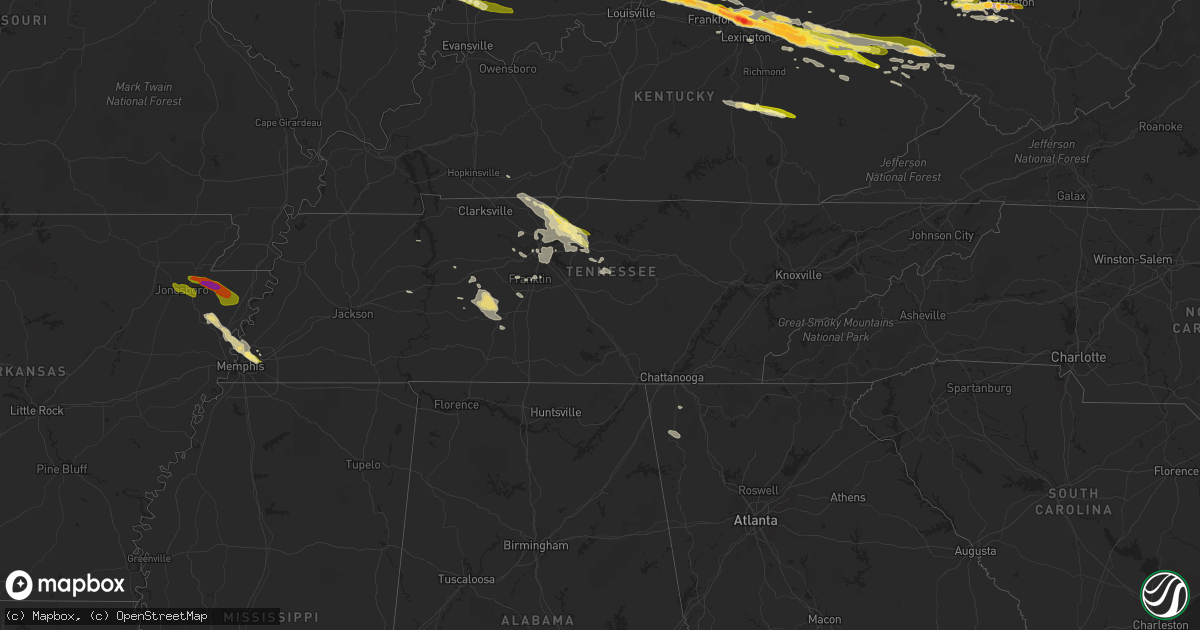
Hail Map in Tennessee on October 7, 2014
Get this storm
October 7 map
$229
one time, instant access
Download today. No call, no setup
Keep the $229
Bought the map and want the full workflow? Apply the entire $229 to a subscription within 7 days. None of it is wasted.
Every map, not just this one
This buys you this map. Subscription and you get every map we run, in the markets you choose from a few cities to whole states to nationwide. Plus real-time alerts the moment a storm fires.
Contact data
Name, contact info, occupancy, even credit band for addresses in the footprint. You go from where it hit to who to call.
Become the source they trust
Unlimited branding weather history reports on demand. You already have the documented answer ready for the property owner, and you are the one who showed up with it.
Property data and RoofTrace estimates
Pull up any address you have got, its value and the exact code rules for that jurisdiction, straight from One Click Code. Then RoofTrace estimates the squares, pitch, and roof value, priced the way you price.
Storm reports in Tennessee
Tennessee
| Date | Description |
|---|---|
| 10/07/20148:14 AM CDT | Quarter size hail reported by mpd near frayser and raleigh. |
| 10/07/20144:05 AM CDT | Several trees down just south of dunlap. |
| 10/07/20143:35 AM CDT | A spotter reported a 60 mph wind gust in mount pleasant. |
| 10/07/20143:30 AM CDT | Several trees reported down near the city of dayton. |
| 10/07/20143:26 AM CDT | Trees were blown down near hampshire. |
| 10/07/20141:00 AM CDT | Public report of quarter size hail in lebanon |
| 10/07/201412:48 AM CDT | Nickel to quarter size hail reported at odoms bend road at steam plant road |
| 10/07/201412:39 AM CDT | Two reports of quarter size hail around gallatin |
| 10/07/201412:10 AM CDT | Quarter size hail reported in gallatin via spotternetwork |
| 10/07/201412:03 AM CDT | A large tree limb was blown down blocking highway 25 near vantrese lane |
| 10/06/201411:40 PM CDT | Public reported hail slightly larger than quarter size in cross plains |
| 10/06/201411:38 PM CDT | Spotter reported small tree limbs down and winds estimated up to 60 mph |
| 10/06/201411:35 PM CDT | Public estimated winds up to 70 mph in cross plains |
All States Impacted by Hail Map on October 7, 2014
Cities Impacted by Hail Map on October 7, 2014
- Ashland City, TN
- Joelton, TN
- Corinth, KY
- Owenton, KY
- Chester, AR
- Sumerco, WV
- Nellis, WV
- Alum Creek, WV
- Ashford, WV
- Ridgeview, WV
- Georgetown, KY
- Tornado, WV
- Loogootee, IN
- Odon, IN
- Memphis, TN
- Gilmore, AR
- Millington, TN
- Marked Tree, AR
- Tyronza, AR
- Bassett, AR
- Lepanto, AR
- Turrell, AR
- Eminence, KY
- Versailles, KY
- Akron, IN
- Hutsonville, IL
- Merom, IN
- West Union, IL
- West York, IL
- Fairbanks, IN
- Sullivan, IN
- Shelburn, IN
- Huntington, IN
- Memphis, IN
- Saint Albans, WV
- Westport, KY
- Pendleton, KY
- Van Buren, AR
- Alma, AR
- Crane, IN
- Hazel Green, KY
- Prospect, KY
- Mize, KY
- Sitka, KY
- Louisa, KY
- Olympia, KY
- Jeffersonville, KY
- Ezel, KY
- Bagdad, KY
- Pleasureville, KY
- Borden, IN
- Inez, KY
- Blaine, KY
- Crum, WV
- Flatgap, KY
- Lexington, KY
- Clearfield, KY
- Paris, KY
- Buckner, KY
- Henryville, IN
- Salt Lick, KY
- Crestwood, KY
- Kermit, WV
- La Grange, KY
- Shelbyville, KY
- Hope, KY
- Elkfork, KY
- Carlisle, KY
- Salyersville, KY
- River, KY
- Goshen, KY
- Lowmansville, KY
- Stambaugh, KY
- Salem, IN
- Means, KY
- Midway, KY
- Tomahawk, KY
- Sharpsburg, KY
- Ulysses, KY
- Sandy Hook, KY
- Sellersburg, IN
- Mount Sterling, KY
- Charlestown, IN
- Frenchburg, KY
- Frankfort, KY
- Winchester, KY
- Martha, KY
- Warfield, KY
- Stamping Ground, KY
- Smithfield, KY
- Pekin, IN
- North Middletown, KY
- Denniston, KY
- Sadieville, KY
- Keaton, KY
- Isonville, KY
- West Liberty, KY
- Wellington, KY
- Morehead, KY
- Owingsville, KY
- Paintsville, KY
- Franklin, TN
- Slade, KY
- Pine Ridge, KY
- Stanton, KY
- Noble, IL
- Hurricane, WV
- Charleston, WV
- Hamlin, WV
- West Hamlin, WV
- Barboursville, WV
- Sod, WV
- Griffithsville, WV
- Salt Rock, WV
- South Charleston, WV
- Milton, WV
- Culloden, WV
- Natural Dam, AR
- Stilwell, OK
- Orleans, IN
- Mitchell, IN
- Mount Carmel, IL
- Decker, IN
- Bunch, OK
- Rochester, IN
- Silver Lake, IN
- North Manchester, IN
- Laketon, IN
- Roann, IN
- Mulberry, AR
- Mountainburg, AR
- Servia, IN
- Urbana, IN
- Oakland City, IN
- Princeton, IN
- Francisco, IN
- Owensville, IN
- Allendale, IL
- Patoka, IN
- Olney, IL
- Parkersburg, IL
- Clay City, IL
- West Salem, IL
- Mount Erie, IL
- Hazleton, IN
- Thompsons Station, TN
- Columbia, TN
- Spring Hill, TN
- Myra, WV
- Lebanon, TN
- Gallatin, TN
- Cottontown, TN
- Pegram, TN
- Pilgrim, KY
- Mount Pleasant, TN
- Nashville, TN
- Lyons, IN
- Linton, IN
- Rock Spring, GA
- La Fayette, GA
- Branchland, WV
- Hendersonville, TN
- Cross Plains, TN
- White House, TN
- Glenwood, WV
- Ashton, WV
- New Castle, KY
- Sulphur, KY
- Bethlehem, KY
- Winifrede, WV
- Hernshaw, WV
- Arlington, TN
- Williamsport, TN
- Duck River, TN
- Hampshire, TN
- Centerville, TN
- Auxier, KY
- East Point, KY
- Prestonsburg, KY
- Mount Vernon, KY
- Orlando, KY
- McKee, KY
- Livingston, KY
- Watertown, TN
- Scott Depot, WV
- Winfield, WV
- Ona, WV
- Nitro, WV
- Flora, IL
- Waynesburg, KY
- Crab Orchard, KY
- Stanford, KY
- Springville, TN
- Big Sandy, TN
- Shoals, IN
- Bloomfield, IN
- Newberry, IN
- Williams, IN
- Scotland, IN
- Campbellsburg, IN
- Bedford, IN
- Goodlettsville, TN
- Mount Juliet, TN
- Springfield, TN
- Hagerhill, KY
- West Van Lear, KY
- Van Lear, KY
- Meally, KY
- Debord, KY
- Yawkey, WV
- Alkol, WV
- Brentwood, TN
- Antioch, TN
- Madison, TN
- Hermitage, TN
- Castalian Springs, TN
- Greenbrier, TN
- Uniontown, AR
- Poca, WV
- Wildersville, TN
- Holladay, TN
- Lyles, TN
- Martinsville, IL
- Nunnelly, TN
- Westville, OK
- Brodhead, KY
- Irvine, KY
- McEwen, TN
- Evansville, AR
- Canehill, AR
- Rudy, AR
- Campton, KY
- Vancleve, KY
- Clay City, KY
- Turners Station, KY
- Campbellsburg, KY
- Bedford, KY
- Lockport, KY
- Blue River, KY
- Lowell, AR
- Springdale, AR
- Bon Aqua, TN
- Dickson, TN
- Cedar Hill, TN
- Olmstead, KY
- Whites Creek, TN
- Old Hickory, TN
- Orlinda, TN
- Adairville, KY
- Williamsport, KY
- Boons Camp, KY
- Elkton, KY
- Trion, GA
- Summerville, GA
- Alexandria, TN
- Liberty, TN
- Woodbury, TN
- Auburntown, TN
- Williamson, WV
- Lenore, WV
- Delbarton, WV
- Lovely, KY
- Oil Springs, KY
- Tutor Key, KY
- Staffordsville, KY
- Winslow, IN
- Huntingburg, IN
- Calhoun, IL
- Holland, IN
- Stendal, IN
- Marshall, IL
- Springville, IN
- Annville, KY
- Fort Gay, WV
- Portland, TN
- Andrews, IN
- Monette, AR
- Lake City, AR
- Brookland, AR
- Manila, AR
- Osceola, AR
- Etowah, AR
- Keiser, AR
- Jonesboro, AR
- Caraway, AR
- Black Oak, AR
- Leachville, AR
- Cordova, TN
- Bono, AR
- State University, AR
- Bay, AR


