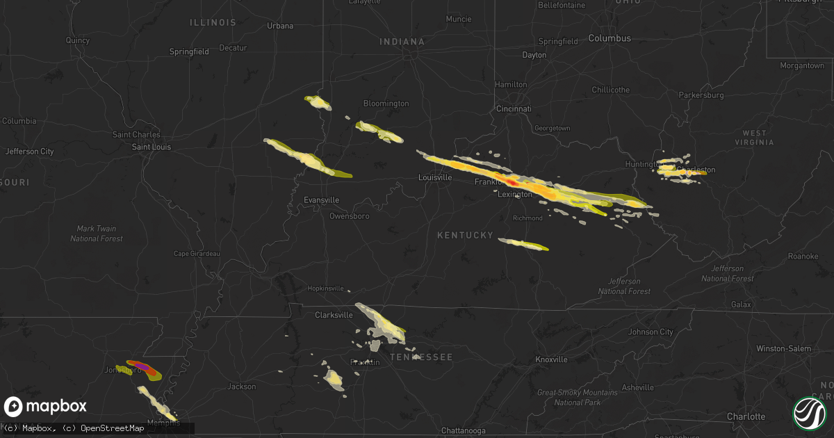
Hail Map in Kentucky on October 7, 2014
Get this storm
October 7 map
$229
one time, instant access
Download today. No call, no setup
Keep the $229
Bought the map and want the full workflow? Apply the entire $229 to a subscription within 7 days. None of it is wasted.
Every map, not just this one
This buys you this map. Subscription and you get every map we run, in the markets you choose from a few cities to whole states to nationwide. Plus real-time alerts the moment a storm fires.
Contact data
Name, contact info, occupancy, even credit band for addresses in the footprint. You go from where it hit to who to call.
Become the source they trust
Unlimited branding weather history reports on demand. You already have the documented answer ready for the property owner, and you are the one who showed up with it.
Property data and RoofTrace estimates
Pull up any address you have got, its value and the exact code rules for that jurisdiction, straight from One Click Code. Then RoofTrace estimates the squares, pitch, and roof value, priced the way you price.
Storm reports in Kentucky
Kentucky
| Date | Description |
|---|---|
| 10/07/20146:33 PM CDT | A local report indicates 1.00 inch wind near PRESTON |
| 10/07/20146:23 PM CDT | A local report indicates 2.75 inch wind near GEORGETOWN |
| 10/07/20146:20 PM CDT | A local report indicates 1.75 inch wind near 3 W GEORGETOWN |
| 10/07/20146:15 PM CDT | A local report indicates 1.50 inch wind near 1 SE LA GRANGE |
| 10/07/20146:15 PM CDT | A local report indicates 1.75 inch wind near 2 W STAMPING GROUND |
| 10/07/20146:08 PM CDT | A local report indicates 1.75 inch wind near SIDEVIEW |
| 10/07/20145:58 PM CDT | A local report indicates 1.00 inch wind near 5 NNW FORKS OF ELKHORN |
| 10/07/20145:44 PM CDT | A local report indicates 1.75 inch wind near PLEASUREVILLE |
| 10/07/20145:41 PM CDT | A local report indicates 1.00 inch wind near EMINENCE |
| 10/07/20145:30 PM CDT | A local report indicates 1.25 inch wind near WELLINGTON |
| 10/07/20145:17 PM CDT | Oldham county dispatch received several reports of rotation and funnel clouds across the county. Also reported golf ball sized hail. |
| 10/07/20144:45 PM CDT | A large tree limb was blown down onto a vehicle in downtown hazard. The time of the event is estimated from radar. |
| 10/07/20144:45 PM CDT | Large tree down near highway 2011 on old house branch road. |
| 10/07/20144:43 PM CDT | Trees down in the industrial park. |
| 10/07/20144:00 PM CDT | Several large limbs down due to strong gusty winds. |
| 10/07/20143:57 PM CDT | Boat truck and camper damaged. Roof or structural damage. Occurred on mud lick road. |
| 10/07/20143:54 PM CDT | Multiple trees were blown down onto mudlick road about halfway between olympia springs and salt lick. |
| 10/07/20143:53 PM CDT | An ef-1 tornado with peak winds estimated at 90 mph touched down 0.9 miles ne of olympia springs and dissipated 1.0 miles nne of olympia springs. The tornado had a path |
| 10/07/20143:52 PM CDT | A local report indicates 1.00 inch wind near 1 NE BRODHEAD |
| 10/07/20143:45 PM CDT | A tree was blown down on a house. |
| 10/07/20143:38 PM CDT | A local report indicates 1.00 inch wind near CRAB ORCHARD |
| 10/07/20143:35 PM CDT | An ef-1 tornado with peak winds of 90 mph touched down about 0.6 miles nw of sharpsburg and lifted about 0.7 miles north of the city. Path length was about 0.6 miles wi |
| 10/07/20143:33 PM CDT | Several large limbs down. |
| 10/07/20143:30 PM CDT | Several large limbs down. |
| 10/07/20143:15 PM CDT | Downed trees blocking mayme lane |
| 10/07/20143:15 PM CDT | 15 to 20 structures damaged on vine street in paris |
| 10/07/20143:13 PM CDT | A local report indicates 1.00 inch wind near PARIS |
| 10/07/20143:12 PM CDT | *** 1 inj *** an ef-1 tornado with maximum winds of 100 mph touched down one half mile south of paris and lifted 1.25 miles northeast of paris. Several homes sustained |
| 10/07/20143:12 PM CDT | Numerous power lines and power poles down across the city with power out citywide |
| 10/07/20143:09 PM CDT | An ef-1 tornado with maximum winds of 110 mph touched down about 3 miles sw of cynthiana and lifted about 2 miles south of the city. Path length was almost 2 miles with |
| 10/07/20143:09 PM CDT | Barns and small buildings blown down in the wornall lane area as well as several trees down |
| 10/07/20143:05 PM CDT | An ef-1 tornado with maximum winds of 110 mph touched down about 3.5 miles wsw of cynthiana and lifted about 2 miles south of the city. Path length was almost 4 miles w |
| 10/07/20142:56 PM CDT | Trees down aa highway at tucker drive. |
| 10/07/20142:56 PM CDT | Pea size hail also reported. |
| 10/07/20142:55 PM CDT | A local report indicates 60 MPH wind near KYMESO MAYSVILLE 3SW |
| 10/07/20142:52 PM CDT | Straight line winds caused damage to homes and businesses in a commercial area near maysville. Wind speeds were estimated at 70 mph. |
| 10/07/20142:50 PM CDT | Mostly tree damage. Two small barns destroyed. Roof damage to two homes. |
| 10/07/20142:48 PM CDT | One tree down |
| 10/07/20142:48 PM CDT | The tornado began as a ef-0 with 80 mph winds as it snapped and uprooted multiple trees and caused minor siding damage. It then traveled eastward and strengthened to 10 |
| 10/07/20142:45 PM CDT | Mostly tree damage done from owen coutny line to 4 n sadieville |
| 10/07/20142:42 PM CDT | An ef0 tornado damaged trees and homes in eastern owen county. Wind speeds were estimated at 80 mph. |
| 10/07/20142:40 PM CDT | Several trees down near switzer and bald knob. Powerlines down near switzer too. |
| 10/07/20142:40 PM CDT | Report of barns down trees down and homes damaged on stonetown road |
| 10/07/20142:40 PM CDT | Svrl lg trees down se part of county |
| 10/07/20142:32 PM CDT | Pea to quarter size hail in the peaks mill area |
| 10/07/20142:07 PM CDT | Windshield cracked on car due to hail. |
| 10/07/20141:54 PM CDT | Multiple trees down |
| 10/07/20141:50 PM CDT | Ef-1 tornado briefly touched down in northern oldham county. Damage included a barn... Several outbuildings... And several snapped large hardwood tree limbs and two who |
| 10/06/20149:55 PM CDT | Tree down in zebulon near highway 119. |
| 10/06/20149:44 PM CDT | An ef-1 tornado with peak winds estimated at 90 mph touched down about 2.6 miles southwest of gulnare and dissipated approximately 2.6 miles southwest of gulnare. The t |
| 10/06/20149:44 PM CDT | A few trees were uprooted and structural damage occurred. |
| 10/06/20149:39 PM CDT | A large tree limb was blown down. |
| 10/06/20149:18 PM CDT | Tree down on half mountain road near kentucky highway 7. |
| 10/06/20148:13 PM CDT | A local report indicates 1.00 inch wind near 5 N SALYERSVILLE |
| 10/06/20147:50 PM CDT | A local report indicates 1.00 inch wind near MOUNT STERLING |
| 10/06/20147:50 PM CDT | Golf ball size hail reported on ky 1690 near the martin county line. |
| 10/06/20147:40 PM CDT | Hail to the half dollar size reported in downtown blaine. |
| 10/06/20147:31 PM CDT | One tree was reported to have been blown down. |
| 10/06/20147:27 PM CDT | Uprooted tree... Caused roof damage to home... Tore roof off building. |
| 10/06/20147:25 PM CDT | A local report indicates 1.25 inch wind near 3 NE JEFFERSONVILLE |
| 10/06/20147:23 PM CDT | Large tree limbs downed. |
| 10/06/20147:23 PM CDT | A local report indicates 1.00 inch wind near 11 NE WEST LIBERTY |
| 10/06/20147:08 PM CDT | A local report indicates 1.75 inch wind near MOUNT STERLING |
| 10/06/20147:08 PM CDT | A local report indicates 1.00 inch wind near 3 WNW WEST LIBERTY |
| 10/06/20147:07 PM CDT | Roof blown off garage... Chimney knocked off house... And several trees snapped off. Damage occured in west liberty on highway 460 west. |
| 10/06/20147:05 PM CDT | A local report indicates 1.00 inch wind near MOUNT STERLING |
| 10/06/20147:05 PM CDT | One inch size hail reported. |
| 10/06/20147:05 PM CDT | A local report indicates 1.75 inch wind near GEORGETOWN |
| 10/06/20147:03 PM CDT | Several trees down near the intersection of highway 705 and highway 3345. |
All States Impacted by Hail Map on October 7, 2014
Cities Impacted by Hail Map on October 7, 2014
- Ashland City, TN
- Joelton, TN
- Corinth, KY
- Owenton, KY
- Chester, AR
- Sumerco, WV
- Nellis, WV
- Alum Creek, WV
- Ashford, WV
- Ridgeview, WV
- Georgetown, KY
- Tornado, WV
- Loogootee, IN
- Odon, IN
- Memphis, TN
- Gilmore, AR
- Millington, TN
- Marked Tree, AR
- Tyronza, AR
- Bassett, AR
- Lepanto, AR
- Turrell, AR
- Eminence, KY
- Versailles, KY
- Akron, IN
- Hutsonville, IL
- Merom, IN
- West Union, IL
- West York, IL
- Fairbanks, IN
- Sullivan, IN
- Shelburn, IN
- Huntington, IN
- Memphis, IN
- Saint Albans, WV
- Westport, KY
- Pendleton, KY
- Van Buren, AR
- Alma, AR
- Crane, IN
- Hazel Green, KY
- Prospect, KY
- Mize, KY
- Sitka, KY
- Louisa, KY
- Olympia, KY
- Jeffersonville, KY
- Ezel, KY
- Bagdad, KY
- Pleasureville, KY
- Borden, IN
- Inez, KY
- Blaine, KY
- Crum, WV
- Flatgap, KY
- Lexington, KY
- Clearfield, KY
- Paris, KY
- Buckner, KY
- Henryville, IN
- Salt Lick, KY
- Crestwood, KY
- Kermit, WV
- La Grange, KY
- Shelbyville, KY
- Hope, KY
- Elkfork, KY
- Carlisle, KY
- Salyersville, KY
- River, KY
- Goshen, KY
- Lowmansville, KY
- Stambaugh, KY
- Salem, IN
- Means, KY
- Midway, KY
- Tomahawk, KY
- Sharpsburg, KY
- Ulysses, KY
- Sandy Hook, KY
- Sellersburg, IN
- Mount Sterling, KY
- Charlestown, IN
- Frenchburg, KY
- Frankfort, KY
- Winchester, KY
- Martha, KY
- Warfield, KY
- Stamping Ground, KY
- Smithfield, KY
- Pekin, IN
- North Middletown, KY
- Denniston, KY
- Sadieville, KY
- Keaton, KY
- Isonville, KY
- West Liberty, KY
- Wellington, KY
- Morehead, KY
- Owingsville, KY
- Paintsville, KY
- Franklin, TN
- Slade, KY
- Pine Ridge, KY
- Stanton, KY
- Noble, IL
- Hurricane, WV
- Charleston, WV
- Hamlin, WV
- West Hamlin, WV
- Barboursville, WV
- Sod, WV
- Griffithsville, WV
- Salt Rock, WV
- South Charleston, WV
- Milton, WV
- Culloden, WV
- Natural Dam, AR
- Stilwell, OK
- Orleans, IN
- Mitchell, IN
- Mount Carmel, IL
- Decker, IN
- Bunch, OK
- Rochester, IN
- Silver Lake, IN
- North Manchester, IN
- Laketon, IN
- Roann, IN
- Mulberry, AR
- Mountainburg, AR
- Servia, IN
- Urbana, IN
- Oakland City, IN
- Princeton, IN
- Francisco, IN
- Owensville, IN
- Allendale, IL
- Patoka, IN
- Olney, IL
- Parkersburg, IL
- Clay City, IL
- West Salem, IL
- Mount Erie, IL
- Hazleton, IN
- Thompsons Station, TN
- Columbia, TN
- Spring Hill, TN
- Myra, WV
- Lebanon, TN
- Gallatin, TN
- Cottontown, TN
- Pegram, TN
- Pilgrim, KY
- Mount Pleasant, TN
- Nashville, TN
- Lyons, IN
- Linton, IN
- Rock Spring, GA
- La Fayette, GA
- Branchland, WV
- Hendersonville, TN
- Cross Plains, TN
- White House, TN
- Glenwood, WV
- Ashton, WV
- New Castle, KY
- Sulphur, KY
- Bethlehem, KY
- Winifrede, WV
- Hernshaw, WV
- Arlington, TN
- Williamsport, TN
- Duck River, TN
- Hampshire, TN
- Centerville, TN
- Auxier, KY
- East Point, KY
- Prestonsburg, KY
- Mount Vernon, KY
- Orlando, KY
- McKee, KY
- Livingston, KY
- Watertown, TN
- Scott Depot, WV
- Winfield, WV
- Ona, WV
- Nitro, WV
- Flora, IL
- Waynesburg, KY
- Crab Orchard, KY
- Stanford, KY
- Springville, TN
- Big Sandy, TN
- Shoals, IN
- Bloomfield, IN
- Newberry, IN
- Williams, IN
- Scotland, IN
- Campbellsburg, IN
- Bedford, IN
- Goodlettsville, TN
- Mount Juliet, TN
- Springfield, TN
- Hagerhill, KY
- West Van Lear, KY
- Van Lear, KY
- Meally, KY
- Debord, KY
- Yawkey, WV
- Alkol, WV
- Brentwood, TN
- Antioch, TN
- Madison, TN
- Hermitage, TN
- Castalian Springs, TN
- Greenbrier, TN
- Uniontown, AR
- Poca, WV
- Wildersville, TN
- Holladay, TN
- Lyles, TN
- Martinsville, IL
- Nunnelly, TN
- Westville, OK
- Brodhead, KY
- Irvine, KY
- McEwen, TN
- Evansville, AR
- Canehill, AR
- Rudy, AR
- Campton, KY
- Vancleve, KY
- Clay City, KY
- Turners Station, KY
- Campbellsburg, KY
- Bedford, KY
- Lockport, KY
- Blue River, KY
- Lowell, AR
- Springdale, AR
- Bon Aqua, TN
- Dickson, TN
- Cedar Hill, TN
- Olmstead, KY
- Whites Creek, TN
- Old Hickory, TN
- Orlinda, TN
- Adairville, KY
- Williamsport, KY
- Boons Camp, KY
- Elkton, KY
- Trion, GA
- Summerville, GA
- Alexandria, TN
- Liberty, TN
- Woodbury, TN
- Auburntown, TN
- Williamson, WV
- Lenore, WV
- Delbarton, WV
- Lovely, KY
- Oil Springs, KY
- Tutor Key, KY
- Staffordsville, KY
- Winslow, IN
- Huntingburg, IN
- Calhoun, IL
- Holland, IN
- Stendal, IN
- Marshall, IL
- Springville, IN
- Annville, KY
- Fort Gay, WV
- Portland, TN
- Andrews, IN
- Monette, AR
- Lake City, AR
- Brookland, AR
- Manila, AR
- Osceola, AR
- Etowah, AR
- Keiser, AR
- Jonesboro, AR
- Caraway, AR
- Black Oak, AR
- Leachville, AR
- Cordova, TN
- Bono, AR
- State University, AR
- Bay, AR


