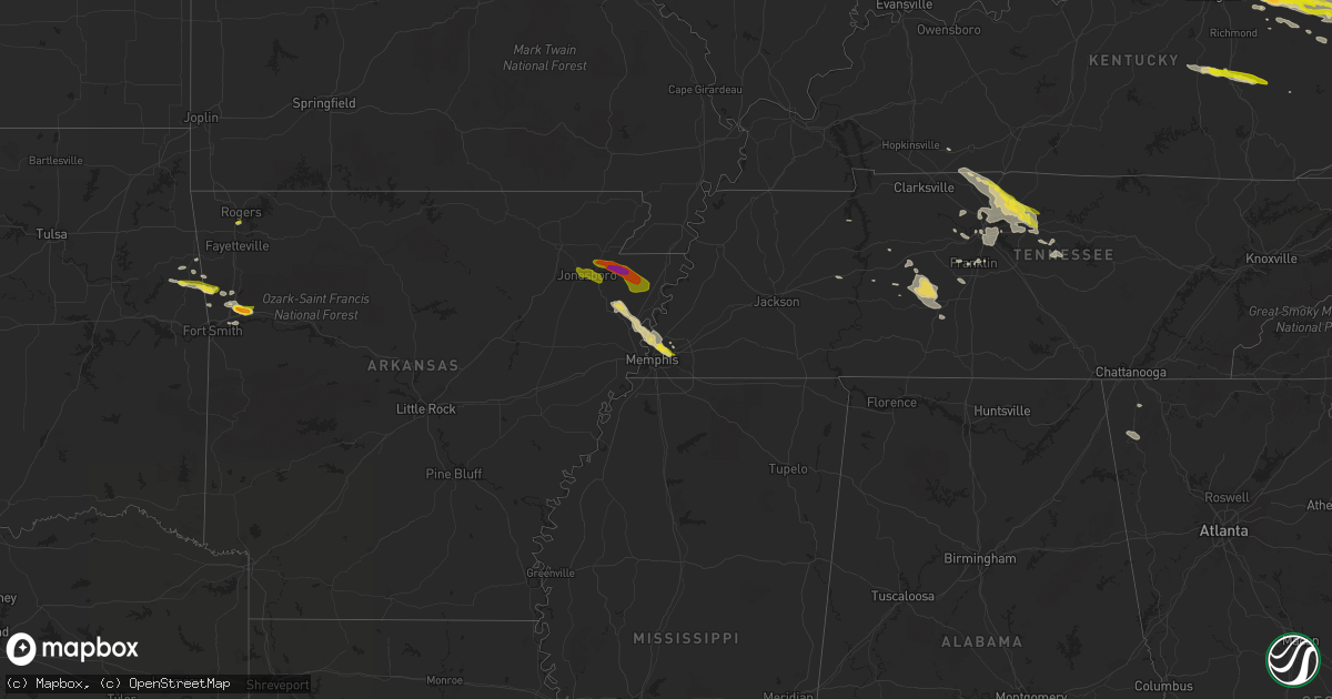
Hail Map on October 7, 2014
Get this storm
October 7 map
$229
one time, instant access
Download today. No call, no setup
Keep the $229
Bought the map and want the full workflow? Apply the entire $229 to a subscription within 7 days. None of it is wasted.
Every map, not just this one
This buys you this map. Subscription and you get every map we run, in the markets you choose from a few cities to whole states to nationwide. Plus real-time alerts the moment a storm fires.
Contact data
Name, contact info, occupancy, even credit band for addresses in the footprint. You go from where it hit to who to call.
Become the source they trust
Unlimited branding weather history reports on demand. You already have the documented answer ready for the property owner, and you are the one who showed up with it.
Property data and RoofTrace estimates
Pull up any address you have got, its value and the exact code rules for that jurisdiction, straight from One Click Code. Then RoofTrace estimates the squares, pitch, and roof value, priced the way you price.
States Impacted by Hail Map on October 7, 2014
Storm reports
West Virginia
| Date | Description |
|---|---|
| 10/07/20145:40 PM CDT | Gusty winds and two inch hail. |
| 10/07/20145:28 PM CDT | Multiple trees and power lines down along chestnut lane |
| 10/07/20145:15 PM CDT | Strong gusty winds to 60 mph and one inch hail. |
| 10/07/20145:15 PM CDT | Strong gusty winds to 60 mph and one inch hail. |
| 10/06/201410:50 PM CDT | A local report indicates 1.00 inch wind near JOLO |
| 10/06/201410:46 PM CDT | Numerous trees down and an outbuilding destroyed. |
| 10/06/201410:44 PM CDT | Trees down and damage to a trailer. |
| 10/06/20149:57 PM CDT | A trained storm spotter reported about ten trees and a power pole blown down near the highway 20 bridge crossing bluestone lake. |
| 10/06/20149:57 PM CDT | Numerous trees and powerlines down. Outhouse taken out. There were several callers to the 911 center that reported seeing some sort of funnel cloud. Search for possible |
| 10/06/20149:45 PM CDT | Ef2 tornado near odd. Estimated maximum wind speed 125 mph. Maximum path width 150 yards . Path length 3.22 miles |
| 10/06/20149:40 PM CDT | Numerous trees and powerlines down. Outhouse taken out. There were several callers to the 911 center that reported seeing some sort of funnel cloud. Search for possible |
| 10/06/20147:57 PM CDT | Hail estimated to be approximately 1.5 inches. Time estimated from radar. |
| 10/06/20147:53 PM CDT | Elongated 2.5 inch hail measured at nws office. |
| 10/06/20147:15 PM CDT | Large pine tree uprooted. Time estimated from radar. |
Maryland
| Date | Description |
|---|---|
| 10/06/201411:00 PM CDT | Several trees down....damage to fences and soffits and heat pumps blown over in the main street...hughlett road...tidewater circle and williamson street area. |
| 10/06/201410:03 PM CDT | Tree down across colton point rd in the 22000 block |
New Hampshire
| Date | Description |
|---|---|
| 10/07/20146:15 AM CDT | 6 inch diameter tree down near route 112 and clearbrook road with strong winds reported at the time. Delayed report. Time estimated from radar. |
| 10/07/20146:02 AM CDT | A local report indicates 77 MPH wind near 4 ESE CENTER HARBOR |
| 10/07/20146:00 AM CDT | Trees down on rt 113 |
| 10/07/20146:00 AM CDT | Multiple reports of trees down. |
Indiana
| Date | Description |
|---|---|
| 10/07/20145:35 PM CDT | Damage survey revealed brief ef0 tornado causing damage to a couple trees. The tornado was sighted by emergency manager observing swirling corn stalks in the air. |
| 10/07/20144:05 PM CDT | A local report indicates 1.00 inch wind near HUNTINGTON |
| 10/07/20144:05 PM CDT | Widespread wind damage around the city of huntington. Reports of trees downed and some larger trees uprooted. |
| 10/07/20143:30 PM CDT | A local report indicates 1.00 inch wind near 1 NE LAKETON |
| 10/07/20143:05 PM CDT | A local report indicates 1.00 inch wind near AKRON |
| 10/07/20142:25 PM CDT | A local report indicates 1.25 inch wind near 4 W ROCHESTER |
| 10/07/20141:40 PM CDT | Roof blown off a laundromat on park street |
| 10/07/20141:32 PM CDT | Broadcast media relayed report of one inch hail in memphis |
| 10/07/201412:05 PM CDT | Winds were also estimated at 50 mph. |
| 10/07/201412:05 PM CDT | Rotation was also noted in clouds. |
| 10/07/20149:50 AM CDT | Quarter size hail and assoicated wind gusts 30 mph. |
| 10/07/20149:40 AM CDT | Wind gust estimated 60 mph. Small hail covering the ground to the point where individuals are using snow shovels to remove it from the sidewalks. |
Ohio
| Date | Description |
|---|---|
| 10/07/20144:45 PM CDT | Trees down near boggs road at lincoln pike. Time estimated from radar. |
| 10/07/20144:42 PM CDT | Mobile home roof was partially lifted off in patriot oh. Time estimated from radar |
| 10/07/20144:38 PM CDT | Roof completely removed from mobile home. |
| 10/07/20144:38 PM CDT | Trees down near mudsoc rd and 141. Time estimated from radar |
| 10/07/20144:25 PM CDT | Route 373 closed due to downed trees at intersection of st rd 93 |
| 10/07/20144:11 PM CDT | Trees down |
| 10/07/20144:10 PM CDT | Trees down |
| 10/07/20143:48 PM CDT | Trees down |
Illinois
| Date | Description |
|---|---|
| 10/07/20148:06 AM CDT | 6 powerpoles... Powerlines... And trees down north of flora. From flora to the west power is out. |
Kentucky
| Date | Description |
|---|---|
| 10/07/20146:33 PM CDT | A local report indicates 1.00 inch wind near PRESTON |
| 10/07/20146:23 PM CDT | A local report indicates 2.75 inch wind near GEORGETOWN |
| 10/07/20146:20 PM CDT | A local report indicates 1.75 inch wind near 3 W GEORGETOWN |
| 10/07/20146:15 PM CDT | A local report indicates 1.50 inch wind near 1 SE LA GRANGE |
| 10/07/20146:15 PM CDT | A local report indicates 1.75 inch wind near 2 W STAMPING GROUND |
| 10/07/20146:08 PM CDT | A local report indicates 1.75 inch wind near SIDEVIEW |
| 10/07/20145:58 PM CDT | A local report indicates 1.00 inch wind near 5 NNW FORKS OF ELKHORN |
| 10/07/20145:44 PM CDT | A local report indicates 1.75 inch wind near PLEASUREVILLE |
| 10/07/20145:41 PM CDT | A local report indicates 1.00 inch wind near EMINENCE |
| 10/07/20145:30 PM CDT | A local report indicates 1.25 inch wind near WELLINGTON |
| 10/07/20145:17 PM CDT | Oldham county dispatch received several reports of rotation and funnel clouds across the county. Also reported golf ball sized hail. |
| 10/07/20144:45 PM CDT | A large tree limb was blown down onto a vehicle in downtown hazard. The time of the event is estimated from radar. |
| 10/07/20144:45 PM CDT | Large tree down near highway 2011 on old house branch road. |
| 10/07/20144:43 PM CDT | Trees down in the industrial park. |
| 10/07/20144:00 PM CDT | Several large limbs down due to strong gusty winds. |
| 10/07/20143:57 PM CDT | Boat truck and camper damaged. Roof or structural damage. Occurred on mud lick road. |
| 10/07/20143:54 PM CDT | Multiple trees were blown down onto mudlick road about halfway between olympia springs and salt lick. |
| 10/07/20143:53 PM CDT | An ef-1 tornado with peak winds estimated at 90 mph touched down 0.9 miles ne of olympia springs and dissipated 1.0 miles nne of olympia springs. The tornado had a path |
| 10/07/20143:52 PM CDT | A local report indicates 1.00 inch wind near 1 NE BRODHEAD |
| 10/07/20143:45 PM CDT | A tree was blown down on a house. |
| 10/07/20143:38 PM CDT | A local report indicates 1.00 inch wind near CRAB ORCHARD |
| 10/07/20143:35 PM CDT | An ef-1 tornado with peak winds of 90 mph touched down about 0.6 miles nw of sharpsburg and lifted about 0.7 miles north of the city. Path length was about 0.6 miles wi |
| 10/07/20143:33 PM CDT | Several large limbs down. |
| 10/07/20143:30 PM CDT | Several large limbs down. |
| 10/07/20143:15 PM CDT | Downed trees blocking mayme lane |
| 10/07/20143:15 PM CDT | 15 to 20 structures damaged on vine street in paris |
| 10/07/20143:13 PM CDT | A local report indicates 1.00 inch wind near PARIS |
| 10/07/20143:12 PM CDT | Numerous power lines and power poles down across the city with power out citywide |
| 10/07/20143:12 PM CDT | *** 1 inj *** an ef-1 tornado with maximum winds of 100 mph touched down one half mile south of paris and lifted 1.25 miles northeast of paris. Several homes sustained |
| 10/07/20143:09 PM CDT | Barns and small buildings blown down in the wornall lane area as well as several trees down |
| 10/07/20143:09 PM CDT | An ef-1 tornado with maximum winds of 110 mph touched down about 3 miles sw of cynthiana and lifted about 2 miles south of the city. Path length was almost 2 miles with |
| 10/07/20143:05 PM CDT | An ef-1 tornado with maximum winds of 110 mph touched down about 3.5 miles wsw of cynthiana and lifted about 2 miles south of the city. Path length was almost 4 miles w |
| 10/07/20142:56 PM CDT | Pea size hail also reported. |
| 10/07/20142:56 PM CDT | Trees down aa highway at tucker drive. |
| 10/07/20142:55 PM CDT | A local report indicates 60 MPH wind near KYMESO MAYSVILLE 3SW |
| 10/07/20142:52 PM CDT | Straight line winds caused damage to homes and businesses in a commercial area near maysville. Wind speeds were estimated at 70 mph. |
| 10/07/20142:50 PM CDT | Mostly tree damage. Two small barns destroyed. Roof damage to two homes. |
| 10/07/20142:48 PM CDT | One tree down |
| 10/07/20142:48 PM CDT | The tornado began as a ef-0 with 80 mph winds as it snapped and uprooted multiple trees and caused minor siding damage. It then traveled eastward and strengthened to 10 |
| 10/07/20142:45 PM CDT | Mostly tree damage done from owen coutny line to 4 n sadieville |
| 10/07/20142:42 PM CDT | An ef0 tornado damaged trees and homes in eastern owen county. Wind speeds were estimated at 80 mph. |
| 10/07/20142:40 PM CDT | Svrl lg trees down se part of county |
| 10/07/20142:40 PM CDT | Several trees down near switzer and bald knob. Powerlines down near switzer too. |
| 10/07/20142:40 PM CDT | Report of barns down trees down and homes damaged on stonetown road |
| 10/07/20142:32 PM CDT | Pea to quarter size hail in the peaks mill area |
| 10/07/20142:07 PM CDT | Windshield cracked on car due to hail. |
| 10/07/20141:54 PM CDT | Multiple trees down |
| 10/07/20141:50 PM CDT | Ef-1 tornado briefly touched down in northern oldham county. Damage included a barn... Several outbuildings... And several snapped large hardwood tree limbs and two who |
| 10/06/20149:55 PM CDT | Tree down in zebulon near highway 119. |
| 10/06/20149:44 PM CDT | A few trees were uprooted and structural damage occurred. |
| 10/06/20149:44 PM CDT | An ef-1 tornado with peak winds estimated at 90 mph touched down about 2.6 miles southwest of gulnare and dissipated approximately 2.6 miles southwest of gulnare. The t |
| 10/06/20149:39 PM CDT | A large tree limb was blown down. |
| 10/06/20149:18 PM CDT | Tree down on half mountain road near kentucky highway 7. |
| 10/06/20148:13 PM CDT | A local report indicates 1.00 inch wind near 5 N SALYERSVILLE |
| 10/06/20147:50 PM CDT | A local report indicates 1.00 inch wind near MOUNT STERLING |
| 10/06/20147:50 PM CDT | Golf ball size hail reported on ky 1690 near the martin county line. |
| 10/06/20147:40 PM CDT | Hail to the half dollar size reported in downtown blaine. |
| 10/06/20147:31 PM CDT | One tree was reported to have been blown down. |
| 10/06/20147:27 PM CDT | Uprooted tree... Caused roof damage to home... Tore roof off building. |
| 10/06/20147:25 PM CDT | A local report indicates 1.25 inch wind near 3 NE JEFFERSONVILLE |
| 10/06/20147:23 PM CDT | A local report indicates 1.00 inch wind near 11 NE WEST LIBERTY |
| 10/06/20147:23 PM CDT | Large tree limbs downed. |
| 10/06/20147:08 PM CDT | A local report indicates 1.75 inch wind near MOUNT STERLING |
| 10/06/20147:08 PM CDT | A local report indicates 1.00 inch wind near 3 WNW WEST LIBERTY |
| 10/06/20147:07 PM CDT | Roof blown off garage... Chimney knocked off house... And several trees snapped off. Damage occured in west liberty on highway 460 west. |
| 10/06/20147:05 PM CDT | A local report indicates 1.00 inch wind near MOUNT STERLING |
| 10/06/20147:05 PM CDT | One inch size hail reported. |
| 10/06/20147:05 PM CDT | A local report indicates 1.75 inch wind near GEORGETOWN |
| 10/06/20147:03 PM CDT | Several trees down near the intersection of highway 705 and highway 3345. |
Oklahoma
| Date | Description |
|---|---|
| 10/07/20144:55 AM CDT | A local report indicates 1.00 inch wind near 4 SE STILWELL |
Arkansas
| Date | Description |
|---|---|
| 10/07/20146:45 AM CDT | A local report indicates 1.00 inch wind near LOWELL |
| 10/07/20146:37 AM CDT | At mile marker 21 on hwy 40 northwest of mulberry. |
Massachusetts
| Date | Description |
|---|---|
| 10/07/20144:20 AM CDT | Trees down on ventura street |
| 10/07/20144:19 AM CDT | Tree down on route 116 blocking the road |
| 10/07/20144:09 AM CDT | Power lines down on dodwells road |
| 10/07/20144:09 AM CDT | Tree and wires down on house on mockanum road |
| 10/07/20144:07 AM CDT | Power lines down on car on mountain road as well as multiple trees down in and around town |
| 10/07/20143:59 AM CDT | Tree on house on aimee road |
| 10/07/20143:56 AM CDT | Tree and wires down on house on mockanum road |
| 10/07/20143:55 AM CDT | Numerous large trees and wires down on york road. Trees fell on several homes and cars causing damage. Several people were trapped in their homes for a time. |
| 10/07/20143:53 AM CDT | Power lines down on car on mountain road...multiple trees down in and around town |
| 10/07/20143:50 AM CDT | Large trees uprooted...one fell on house on aimee road...damage to fencing on property |
| 10/07/20143:45 AM CDT | Power outage due to tree down on wires along feeding hill road |
| 10/07/20143:40 AM CDT | Power outage due to tree down on wires along feeding hill road |
| 10/07/20143:35 AM CDT | Large tree down across route 202 |
Tennessee
| Date | Description |
|---|---|
| 10/07/20148:14 AM CDT | Quarter size hail reported by mpd near frayser and raleigh. |
| 10/07/20144:05 AM CDT | Several trees down just south of dunlap. |
| 10/07/20143:35 AM CDT | A spotter reported a 60 mph wind gust in mount pleasant. |
| 10/07/20143:30 AM CDT | Several trees reported down near the city of dayton. |
| 10/07/20143:26 AM CDT | Trees were blown down near hampshire. |
| 10/07/20141:00 AM CDT | Public report of quarter size hail in lebanon |
| 10/07/201412:48 AM CDT | Nickel to quarter size hail reported at odoms bend road at steam plant road |
| 10/07/201412:39 AM CDT | Two reports of quarter size hail around gallatin |
| 10/07/201412:10 AM CDT | Quarter size hail reported in gallatin via spotternetwork |
| 10/07/201412:03 AM CDT | A large tree limb was blown down blocking highway 25 near vantrese lane |
| 10/06/201411:40 PM CDT | Public reported hail slightly larger than quarter size in cross plains |
| 10/06/201411:38 PM CDT | Spotter reported small tree limbs down and winds estimated up to 60 mph |
| 10/06/201411:35 PM CDT | Public estimated winds up to 70 mph in cross plains |
Virginia
| Date | Description |
|---|---|
| 10/06/201411:47 PM CDT | 3 oak trees blown down. Time from radar. |
| 10/06/201411:47 PM CDT | 2 trees blown down and one tree topped. Time from radar. |
| 10/06/201411:45 PM CDT | Tree down |
| 10/06/201411:27 PM CDT | Numerous large tree limbs down on rte 635 approximately 2 miles northeast of the town of goldbond. |
| 10/06/20147:53 PM CDT | Tree down across road at corner of miller school rd and samuel miller rd |
Cities Impacted by Hail Map on October 7, 2014
- Ashland City, TN
- Joelton, TN
- Corinth, KY
- Owenton, KY
- Chester, AR
- Sumerco, WV
- Nellis, WV
- Alum Creek, WV
- Ashford, WV
- Ridgeview, WV
- Georgetown, KY
- Tornado, WV
- Loogootee, IN
- Odon, IN
- Memphis, TN
- Gilmore, AR
- Millington, TN
- Marked Tree, AR
- Tyronza, AR
- Bassett, AR
- Lepanto, AR
- Turrell, AR
- Eminence, KY
- Versailles, KY
- Akron, IN
- Hutsonville, IL
- Merom, IN
- West Union, IL
- West York, IL
- Fairbanks, IN
- Sullivan, IN
- Shelburn, IN
- Huntington, IN
- Memphis, IN
- Saint Albans, WV
- Westport, KY
- Pendleton, KY
- Van Buren, AR
- Alma, AR
- Crane, IN
- Hazel Green, KY
- Prospect, KY
- Mize, KY
- Sitka, KY
- Louisa, KY
- Olympia, KY
- Jeffersonville, KY
- Ezel, KY
- Bagdad, KY
- Pleasureville, KY
- Borden, IN
- Inez, KY
- Blaine, KY
- Crum, WV
- Flatgap, KY
- Lexington, KY
- Clearfield, KY
- Paris, KY
- Buckner, KY
- Henryville, IN
- Salt Lick, KY
- Crestwood, KY
- Kermit, WV
- La Grange, KY
- Shelbyville, KY
- Hope, KY
- Elkfork, KY
- Carlisle, KY
- Salyersville, KY
- River, KY
- Goshen, KY
- Lowmansville, KY
- Stambaugh, KY
- Salem, IN
- Means, KY
- Midway, KY
- Tomahawk, KY
- Sharpsburg, KY
- Ulysses, KY
- Sandy Hook, KY
- Sellersburg, IN
- Mount Sterling, KY
- Charlestown, IN
- Frenchburg, KY
- Frankfort, KY
- Winchester, KY
- Martha, KY
- Warfield, KY
- Stamping Ground, KY
- Smithfield, KY
- Pekin, IN
- North Middletown, KY
- Denniston, KY
- Sadieville, KY
- Keaton, KY
- Isonville, KY
- West Liberty, KY
- Wellington, KY
- Morehead, KY
- Owingsville, KY
- Paintsville, KY
- Franklin, TN
- Slade, KY
- Pine Ridge, KY
- Stanton, KY
- Noble, IL
- Hurricane, WV
- Charleston, WV
- Hamlin, WV
- West Hamlin, WV
- Barboursville, WV
- Sod, WV
- Griffithsville, WV
- Salt Rock, WV
- South Charleston, WV
- Milton, WV
- Culloden, WV
- Natural Dam, AR
- Stilwell, OK
- Orleans, IN
- Mitchell, IN
- Mount Carmel, IL
- Decker, IN
- Bunch, OK
- Rochester, IN
- Silver Lake, IN
- North Manchester, IN
- Laketon, IN
- Roann, IN
- Mulberry, AR
- Mountainburg, AR
- Servia, IN
- Urbana, IN
- Oakland City, IN
- Princeton, IN
- Francisco, IN
- Owensville, IN
- Allendale, IL
- Patoka, IN
- Olney, IL
- Parkersburg, IL
- Clay City, IL
- West Salem, IL
- Mount Erie, IL
- Hazleton, IN
- Thompsons Station, TN
- Columbia, TN
- Spring Hill, TN
- Myra, WV
- Lebanon, TN
- Gallatin, TN
- Cottontown, TN
- Pegram, TN
- Pilgrim, KY
- Mount Pleasant, TN
- Nashville, TN
- Lyons, IN
- Linton, IN
- Rock Spring, GA
- La Fayette, GA
- Branchland, WV
- Hendersonville, TN
- Cross Plains, TN
- White House, TN
- Glenwood, WV
- Ashton, WV
- New Castle, KY
- Sulphur, KY
- Bethlehem, KY
- Winifrede, WV
- Hernshaw, WV
- Arlington, TN
- Williamsport, TN
- Duck River, TN
- Hampshire, TN
- Centerville, TN
- Auxier, KY
- East Point, KY
- Prestonsburg, KY
- Mount Vernon, KY
- Orlando, KY
- McKee, KY
- Livingston, KY
- Watertown, TN
- Scott Depot, WV
- Winfield, WV
- Ona, WV
- Nitro, WV
- Flora, IL
- Waynesburg, KY
- Crab Orchard, KY
- Stanford, KY
- Springville, TN
- Big Sandy, TN
- Shoals, IN
- Bloomfield, IN
- Newberry, IN
- Williams, IN
- Scotland, IN
- Campbellsburg, IN
- Bedford, IN
- Goodlettsville, TN
- Mount Juliet, TN
- Springfield, TN
- Hagerhill, KY
- West Van Lear, KY
- Van Lear, KY
- Meally, KY
- Debord, KY
- Yawkey, WV
- Alkol, WV
- Brentwood, TN
- Antioch, TN
- Madison, TN
- Hermitage, TN
- Castalian Springs, TN
- Greenbrier, TN
- Uniontown, AR
- Poca, WV
- Wildersville, TN
- Holladay, TN
- Lyles, TN
- Martinsville, IL
- Nunnelly, TN
- Westville, OK
- Brodhead, KY
- Irvine, KY
- McEwen, TN
- Evansville, AR
- Canehill, AR
- Rudy, AR
- Campton, KY
- Vancleve, KY
- Clay City, KY
- Turners Station, KY
- Campbellsburg, KY
- Bedford, KY
- Lockport, KY
- Blue River, KY
- Lowell, AR
- Springdale, AR
- Bon Aqua, TN
- Dickson, TN
- Cedar Hill, TN
- Olmstead, KY
- Whites Creek, TN
- Old Hickory, TN
- Orlinda, TN
- Adairville, KY
- Williamsport, KY
- Boons Camp, KY
- Elkton, KY
- Trion, GA
- Summerville, GA
- Alexandria, TN
- Liberty, TN
- Woodbury, TN
- Auburntown, TN
- Williamson, WV
- Lenore, WV
- Delbarton, WV
- Lovely, KY
- Oil Springs, KY
- Tutor Key, KY
- Staffordsville, KY
- Winslow, IN
- Huntingburg, IN
- Calhoun, IL
- Holland, IN
- Stendal, IN
- Marshall, IL
- Springville, IN
- Annville, KY
- Fort Gay, WV
- Portland, TN
- Andrews, IN
- Monette, AR
- Lake City, AR
- Brookland, AR
- Manila, AR
- Osceola, AR
- Etowah, AR
- Keiser, AR
- Jonesboro, AR
- Caraway, AR
- Black Oak, AR
- Leachville, AR
- Cordova, TN
- Bono, AR
- State University, AR
- Bay, AR