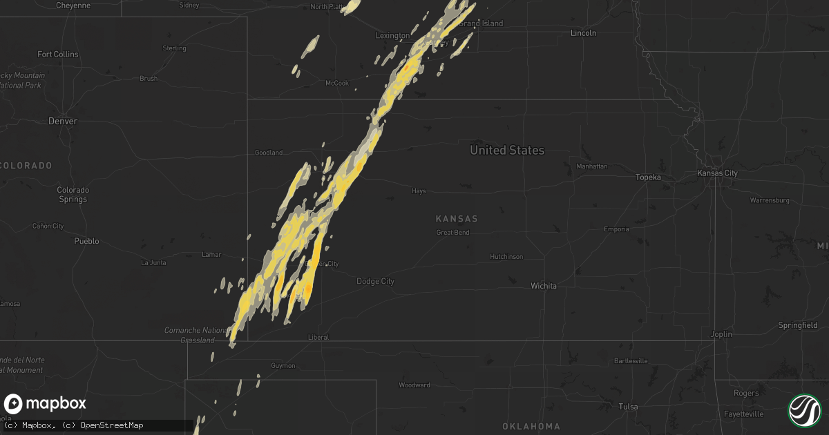
Hail Map in Nebraska on October 7, 2011
Get this storm
October 7 map
$229
one time, instant access
Download today. No call, no setup
Keep the $229
Bought the map and want the full workflow? Apply the entire $229 to a subscription within 7 days. None of it is wasted.
Every map, not just this one
This buys you this map. Subscription and you get every map we run, in the markets you choose from a few cities to whole states to nationwide. Plus real-time alerts the moment a storm fires.
Contact data
Name, contact info, occupancy, even credit band for addresses in the footprint. You go from where it hit to who to call.
Become the source they trust
Unlimited branding weather history reports on demand. You already have the documented answer ready for the property owner, and you are the one who showed up with it.
Property data and RoofTrace estimates
Pull up any address you have got, its value and the exact code rules for that jurisdiction, straight from One Click Code. Then RoofTrace estimates the squares, pitch, and roof value, priced the way you price.
Storm reports in Nebraska
Nebraska
| Date | Description |
|---|---|
| 10/07/20115:43 PM CDT | A local report indicates 59 MPH wind near KEARNEY AIRPORT |
| 10/07/20115:35 PM CDT | Emergency manger relayed a report from a dispatcher that quarter size hail was falling on the northwest side of kearney. |
| 10/07/20114:40 PM CDT | Half of a roof removed from a grain storage building on the south edge of atlanta |
| 10/07/20113:25 PM CDT | Brief nickel to quarter size hail |
| 10/07/201112:15 AM CDT | A local report indicates 63 MPH wind near HOLDREGE AIRPORT |
| 10/06/20119:50 PM CDT | A local report indicates 60 MPH wind near 10 E RAVENNA |
| 10/06/20117:45 PM CDT | Measured by awos |
| 10/06/20117:30 PM CDT | A local report indicates 1.75 inch wind near ATLANTA |
| 10/06/20117:00 PM CDT | Delayed report of quarter size hail. |
All States Impacted by Hail Map on October 7, 2011
Cities Impacted by Hail Map on October 7, 2011
- Winona, KS
- Ropesville, TX
- Meadow, TX
- Amherst, NE
- Pleasanton, NE
- Garden City, TX
- Grainfield, KS
- Levelland, TX
- Odessa, TX
- Brandt, SD
- Colby, KS
- Monument, KS
- Portales, NM
- Grand Island, NE
- Kearney, NE
- Ravenna, NE
- Shelton, NE
- Gibbon, NE
- Dannebrog, NE
- Wood River, NE
- Cairo, NE
- Saint Paul, NE
- Spalding, NE
- Bloomfield, NE
- Crofton, NE
- Astoria, SD
- White, SD
- Toronto, SD
- Muleshoe, TX
- Stamford, NE
- Grinnell, KS
- Healy, KS
- Johnson, KS
- Oakley, KS
- Syracuse, KS
- Kendall, KS
- Marienthal, KS
- Park, KS
- Ulysses, KS
- Deerfield, KS
- Lakin, KS
- Hoxie, KS
- Gove, KS
- Scott City, KS
- Quinter, KS
- Morland, KS
- Leoti, KS
- Wolbach, NE
- Big Spring, TX
- Axtell, NE
- Holdrege, NE
- Orleans, NE
- Elida, NM
- Stanton, TX
- Crane, TX
- Clearwater, NE
- Brownfield, TX
- Tokio, TX
- Marietta, MN
- Boise City, OK
- Winfred, SD
- Ramona, SD
- Slaton, TX
- Lubbock, TX
- Palisade, NE
- Wauneta, NE
- Boelus, NE
- Holcomb, KS
- Garden City, KS
- Ashton, NE
- Rockville, NE
- Farwell, NE
- Ralls, TX
- Campo, CO
- Walsh, CO
- Manter, KS
- Satanta, KS
- Hugoton, KS
- Hill City, KS
- Bertrand, NE
- Beaver City, NE
- Funk, NE
- Norton, KS
- Oxford, NE
- Atlanta, NE
- Loomis, NE
- Rexford, KS
- Alexandria, SD
- Yankton, SD
- Lorenzo, TX
- Morton, TX
- Clovis, NM
- Lenora, KS
- Selden, KS
- Bard, NM
- San Jon, NM
- Volga, SD
- Brookings, SD
- Bruce, SD
- Midland, TX
- Pep, NM
- Causey, NM
- Rogers, NM
- Miller, NE
- Elm Creek, NE
- Overton, NE
- Denver City, TX
- Holly, CO
- Gary, SD
- Milnesand, NM
- Gardendale, TX
- Melrose, NM
- Floyd, NM
- Riverdale, NE
- Dalhart, TX
- Gail, TX
- Texhoma, OK
- Crosbyton, TX
- Tucumcari, NM
- Midkiff, TX
- Canova, SD
- Penokee, KS
- Post, TX
- Juniata, NE
- Kenesaw, NE
- Sauk Centre, MN
- Glenwood, MN
- Brooten, MN
- Villard, MN
- Lexington, NE
- Clear Lake, SD
- Arlington, SD
- Sinai, SD
- Canby, MN
- Wellfleet, NE
- Stratford, TX
- Brady, NE
- Logan, NM
- Grady, NM
- Coahoma, TX
- Neligh, NE
- Springfield, CO
- Broadview, NM
- Murdock, MN
- Montevideo, MN
- Maxwell, NE
- Lenorah, TX
- Milan, MN
- Granada, CO
- Hendley, NE
- Edison, NE
- Richfield, KS
- Tahoka, TX
- Channing, TX
- Tilden, NE
- Hazard, NE
- Tarzan, TX
- Minden, NE
- Elkhart, KS
- Odessa, NE
- Alma, NE
- Clayton, KS
- Wilcox, NE
- Almena, KS
- Keyes, OK
- Hayes Center, NE
- Heartwell, NE
- Cannon Afb, NM
- Dickens, NE
- Central City, NE
- Fullerton, NE
- Gothenburg, NE
- Loup City, NE
- Snyder, TX
- North Loup, NE
- Ord, NE
- Howard, SD
- Doniphan, NE
- Indianola, NE
- Nara Visa, NM
- Madrid, NE
- Crossroads, NM
- Holbrook, NE
- Elwood, NE
- Eustis, NE
- Plains, TX
- Arapahoe, NE
- Smithfield, NE
- Idalou, TX
- Saint Edward, NE
- Genoa, NE
- Spencer, SD
- Goldsmith, TX
- Alda, NE
- Tribune, KS
- Appleton, MN
- Knott, TX
- Oldham, SD
- Hildreth, NE
- Cambridge, NE
- Tatum, NM
- Saint Helena, NE
- Saint Libory, NE
- Hale Center, TX
- Abernathy, TX
- Ackerly, TX


