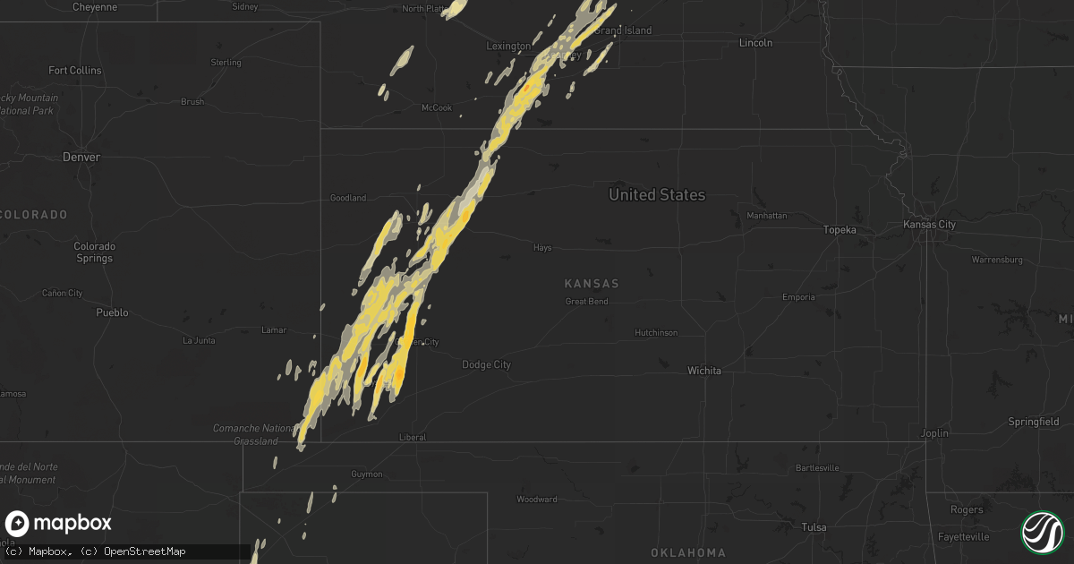
Hail Map in Kansas on October 7, 2011
Get this storm
October 7 map
$229
one time, instant access
Download today. No call, no setup
Keep the $229
Bought the map and want the full workflow? Apply the entire $229 to a subscription within 7 days. None of it is wasted.
Every map, not just this one
This buys you this map. Subscription and you get every map we run, in the markets you choose from a few cities to whole states to nationwide. Plus real-time alerts the moment a storm fires.
Contact data
Name, contact info, occupancy, even credit band for addresses in the footprint. You go from where it hit to who to call.
Become the source they trust
Unlimited branding weather history reports on demand. You already have the documented answer ready for the property owner, and you are the one who showed up with it.
Property data and RoofTrace estimates
Pull up any address you have got, its value and the exact code rules for that jurisdiction, straight from One Click Code. Then RoofTrace estimates the squares, pitch, and roof value, priced the way you price.
Storm reports in Kansas
Kansas
| Date | Description |
|---|---|
| 10/07/20116:57 PM CDT | A local report indicates 60 MPH wind near 8 NNE HICKOK |
| 10/07/20116:52 PM CDT | A local report indicates 1.25 inch wind near 1 E FRIEND |
| 10/07/20116:40 PM CDT | A local report indicates 1.00 inch wind near 1 ENE FRIEND |
| 10/07/20116:40 PM CDT | A local report indicates 2.00 inch wind near 1 S HOLCOMB |
| 10/07/20116:37 PM CDT | A local report indicates 1.50 inch wind near 5 WNW GARDEN CITY |
| 10/07/20116:35 PM CDT | The emergency manager reported a semi blown over...several power poles blown down...and the roof of an out building blown off...all around the east side the ulysses. |
| 10/07/20116:33 PM CDT | Report relayed from ksn. |
| 10/07/20116:30 PM CDT | A local report indicates 1.75 inch wind near ULYSSES |
| 10/07/20116:25 PM CDT | A local report indicates 1.00 inch wind near 8 N GARDEN CITY |
| 10/07/20116:18 PM CDT | A local report indicates 1.00 inch wind near W HOLCOMB |
| 10/07/20116:00 PM CDT | A local report indicates 60 MPH wind near 7 ENE HICKOK |
| 10/07/20116:00 PM CDT | A local report indicates 2.50 inch wind near 7 ENE HICKOK |
| 10/07/20115:00 AM CDT | The roof was torn off a barn. They received 0.38 inches of rain. |
| 10/07/20115:00 AM CDT | This wind gust was measured by a davis unit. |
| 10/07/20114:53 AM CDT | 18 inch diameter pine tree was snapped off near the base. Shingles were blown off the house. Possible tornado. |
| 10/07/20114:50 AM CDT | A barn was destroyed. |
| 10/07/201112:20 AM CDT | Wind gusts were estimated to be in the 60 to 70 mph range. |
| 10/07/201112:10 AM CDT | A local report indicates a tornado near 4 N MODOC |
| 10/07/201112:05 AM CDT | A local report indicates 60 MPH wind near 1 SW RICHFIELD |
| 10/06/201111:17 PM CDT | Relayed by ksn weather lab |
| 10/06/201111:00 PM CDT | A local report indicates 1.00 inch wind near 5 W KENDALL |
| 10/06/20119:50 PM CDT | An open shed was blown across a road. |
| 10/06/20119:45 PM CDT | A storm chaser reported seeing multiple power flashes and then several minutes later a large funnel cloud wrapped in rain extending more than half way to the surface fr |
| 10/06/20119:15 PM CDT | A local report indicates 1.00 inch wind near 7 WSW SHALLOW WATER |
| 10/06/20119:10 PM CDT | A local report indicates 70 MPH wind near 1 WSW GRIGSTON |
| 10/06/20118:55 PM CDT | A local report indicates 1.00 inch wind near 10 NE KENDALL |
| 10/06/20118:35 PM CDT | A local report indicates 60 MPH wind near 5 WSW MANTER |
| 10/06/20118:12 PM CDT | Resident also reported a ten minute power outage at that location. |
| 10/06/20117:23 PM CDT | A local report indicates 1.75 inch wind near 10 N BIG BOW |
| 10/06/20117:15 PM CDT | The hail was reported to be covering the ground in the big bow area. |
| 10/06/20117:15 PM CDT | A local report indicates 60 MPH wind near 4 NNE BIG BOW |
| 10/06/20117:05 PM CDT | A local report indicates 1.00 inch wind near 7 SSW MENLO |
All States Impacted by Hail Map on October 7, 2011
Cities Impacted by Hail Map on October 7, 2011
- Winona, KS
- Ropesville, TX
- Meadow, TX
- Amherst, NE
- Pleasanton, NE
- Garden City, TX
- Grainfield, KS
- Levelland, TX
- Odessa, TX
- Brandt, SD
- Colby, KS
- Monument, KS
- Portales, NM
- Grand Island, NE
- Kearney, NE
- Ravenna, NE
- Shelton, NE
- Gibbon, NE
- Dannebrog, NE
- Wood River, NE
- Cairo, NE
- Saint Paul, NE
- Spalding, NE
- Bloomfield, NE
- Crofton, NE
- Astoria, SD
- White, SD
- Toronto, SD
- Muleshoe, TX
- Stamford, NE
- Grinnell, KS
- Healy, KS
- Johnson, KS
- Oakley, KS
- Syracuse, KS
- Kendall, KS
- Marienthal, KS
- Park, KS
- Ulysses, KS
- Deerfield, KS
- Lakin, KS
- Hoxie, KS
- Gove, KS
- Scott City, KS
- Quinter, KS
- Morland, KS
- Leoti, KS
- Wolbach, NE
- Big Spring, TX
- Axtell, NE
- Holdrege, NE
- Orleans, NE
- Elida, NM
- Stanton, TX
- Crane, TX
- Clearwater, NE
- Brownfield, TX
- Tokio, TX
- Marietta, MN
- Boise City, OK
- Winfred, SD
- Ramona, SD
- Slaton, TX
- Lubbock, TX
- Palisade, NE
- Wauneta, NE
- Boelus, NE
- Holcomb, KS
- Garden City, KS
- Ashton, NE
- Rockville, NE
- Farwell, NE
- Ralls, TX
- Campo, CO
- Walsh, CO
- Manter, KS
- Satanta, KS
- Hugoton, KS
- Hill City, KS
- Bertrand, NE
- Beaver City, NE
- Funk, NE
- Norton, KS
- Oxford, NE
- Atlanta, NE
- Loomis, NE
- Rexford, KS
- Alexandria, SD
- Yankton, SD
- Lorenzo, TX
- Morton, TX
- Clovis, NM
- Lenora, KS
- Selden, KS
- Bard, NM
- San Jon, NM
- Volga, SD
- Brookings, SD
- Bruce, SD
- Midland, TX
- Pep, NM
- Causey, NM
- Rogers, NM
- Miller, NE
- Elm Creek, NE
- Overton, NE
- Denver City, TX
- Holly, CO
- Gary, SD
- Milnesand, NM
- Gardendale, TX
- Melrose, NM
- Floyd, NM
- Riverdale, NE
- Dalhart, TX
- Gail, TX
- Texhoma, OK
- Crosbyton, TX
- Tucumcari, NM
- Midkiff, TX
- Canova, SD
- Penokee, KS
- Post, TX
- Juniata, NE
- Kenesaw, NE
- Sauk Centre, MN
- Glenwood, MN
- Brooten, MN
- Villard, MN
- Lexington, NE
- Clear Lake, SD
- Arlington, SD
- Sinai, SD
- Canby, MN
- Wellfleet, NE
- Stratford, TX
- Brady, NE
- Logan, NM
- Grady, NM
- Coahoma, TX
- Neligh, NE
- Springfield, CO
- Broadview, NM
- Murdock, MN
- Montevideo, MN
- Maxwell, NE
- Lenorah, TX
- Milan, MN
- Granada, CO
- Hendley, NE
- Edison, NE
- Richfield, KS
- Tahoka, TX
- Channing, TX
- Tilden, NE
- Hazard, NE
- Tarzan, TX
- Minden, NE
- Elkhart, KS
- Odessa, NE
- Alma, NE
- Clayton, KS
- Wilcox, NE
- Almena, KS
- Keyes, OK
- Hayes Center, NE
- Heartwell, NE
- Cannon Afb, NM
- Dickens, NE
- Central City, NE
- Fullerton, NE
- Gothenburg, NE
- Loup City, NE
- Snyder, TX
- North Loup, NE
- Ord, NE
- Howard, SD
- Doniphan, NE
- Indianola, NE
- Nara Visa, NM
- Madrid, NE
- Crossroads, NM
- Holbrook, NE
- Elwood, NE
- Eustis, NE
- Plains, TX
- Arapahoe, NE
- Smithfield, NE
- Idalou, TX
- Saint Edward, NE
- Genoa, NE
- Spencer, SD
- Goldsmith, TX
- Alda, NE
- Tribune, KS
- Appleton, MN
- Knott, TX
- Oldham, SD
- Hildreth, NE
- Cambridge, NE
- Tatum, NM
- Saint Helena, NE
- Saint Libory, NE
- Hale Center, TX
- Abernathy, TX
- Ackerly, TX


