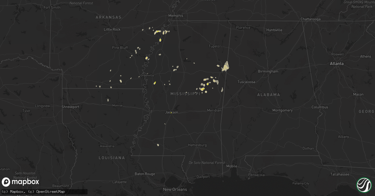
Hail Map in Mississippi on October 5, 2021
Get this storm
October 5 map
$229
one time, instant access
Download today. No call, no setup
Keep the $229
Bought the map and want the full workflow? Apply the entire $229 to a subscription within 7 days. None of it is wasted.
Every map, not just this one
This buys you this map. Subscription and you get every map we run, in the markets you choose from a few cities to whole states to nationwide. Plus real-time alerts the moment a storm fires.
Contact data
Name, contact info, occupancy, even credit band for addresses in the footprint. You go from where it hit to who to call.
Become the source they trust
Unlimited branding weather history reports on demand. You already have the documented answer ready for the property owner, and you are the one who showed up with it.
Property data and RoofTrace estimates
Pull up any address you have got, its value and the exact code rules for that jurisdiction, straight from One Click Code. Then RoofTrace estimates the squares, pitch, and roof value, priced the way you price.
Storm reports in Mississippi
Mississippi
| Date | Description |
|---|---|
| 10/05/20216:48 PM CDT | Tree down on a power line. |
| 10/05/20216:40 PM CDT | Public reports relayed by media. |
| 10/05/20216:20 PM CDT | A local report indicates 1.25 inch wind near 2 SE LOUISVILLE |
| 10/05/20216:10 PM CDT | Report relayed from the mayor of noxapater. |
| 10/05/20216:00 PM CDT | Nickel to quarter hail. |
| 10/05/20214:45 PM CDT | Hail up to around the size of quarters fell near darlove. |
| 10/05/20213:35 PM CDT | Nickel to quarter size hail at lake copiah. |
| 10/05/20213:05 PM CDT | Pictures of golf ball hail in the teoc community. |
| 10/05/20211:47 PM CDT | Hail up to the size of quarters fell along raymond road near the intersection with valley street. Report with video relayed via twitter. |
| 10/05/20212:53 AM CDT | At 753 PM CDT, severe thunderstorms were located along a line extending from near Waverly to near Bigbee Valley, moving northeast at 25 mph. HAZARD...60 mph wind gusts and nickel size hail. SOURCE...Radar indicated. IMPACT...Expect damage to roofs, siding, and trees. Severe thunderstorms will be near... Waverly around 800 PM CDT. Columbus around 805 PM CDT. Columbus AFB around 815 PM CDT. Kolola Springs around 820 PM CDT. Caledonia around 830 PM CDT. Steens around 835 PM CDT.Other locations impacted by these severe thunderstorms includeArtesia. |
| 10/05/20211:29 AM CDT | At 628 PM CDT, severe thunderstorms were located along a line extending from near Betheden to near Vernon to Forestdale, moving east at 15 mph. HAZARD...60 mph wind gusts and half dollar size hail. SOURCE...Radar indicated. IMPACT...Hail damage to vehicles is expected. Expect wind damage to roofs, siding, and trees. Severe thunderstorms will be near... Gholson and Oktoc around 655 PM CDT. Mashulaville around 700 PM CDT.Other locations impacted by these severe thunderstorms includeNoxapater and Sturgis. |
| 10/05/202112:45 AM CDT | At 545 PM CDT, a severe thunderstorm was located near Betheden, or 9 miles north of Louisville, moving south at 10 mph. HAZARD...60 mph wind gusts and quarter size hail. SOURCE...Radar indicated. IMPACT...Hail damage to vehicles is expected. Expect wind damage to roofs, siding, and trees. This severe thunderstorm will be near... Betheden around 600 PM CDT. Mcmillan around 620 PM CDT. Louisville and Millcreek around 625 PM CDT.Other locations impacted by this severe thunderstorm includeNoxapater and Sturgis. |
| 10/05/202112:02 AM CDT | At 502 PM CDT, a severe thunderstorm was located near Zama, or 12 miles north of Edinburg, moving south at 10 mph. HAZARD...60 mph wind gusts and quarter size hail. SOURCE...Radar indicated. IMPACT...Hail damage to vehicles is expected. Expect wind damage to roofs, siding, and trees. This severe thunderstorm will remain over mainly rural areas of northeastern Leake, east central Attala, southwestern Winston and northwestern Neshoba Counties. |
| 10/04/202111:56 PM CDT | At 456 PM CDT, a severe thunderstorm was located near Hollandale, moving southwest at 15 mph. HAZARD...60 mph wind gusts and quarter size hail. SOURCE...Public. IMPACT...Hail damage to vehicles is expected. Expect wind damage to roofs, siding, and trees. This severe thunderstorm will be near... Hollandale around 500 PM CDT. Delta City around 515 PM CDT. Panther Burn around 525 PM CDT. |
| 10/04/202110:28 PM CDT | At 328 PM CDT, a severe thunderstorm was located near Gallman, or near Crystal Springs, moving west at 5 mph. HAZARD...Quarter size hail. SOURCE...Radar indicated. IMPACT...Damage to vehicles is expected. This severe thunderstorm will be near... Dentville around 415 PM CDT. |
| 10/04/202110:04 PM CDT | At 303 PM CDT, a severe thunderstorm was located near Teoc, or near Greenwood, moving southwest at 10 mph. HAZARD...Quarter size hail. SOURCE...Radar indicated. IMPACT...Damage to vehicles is expected. This severe thunderstorm will be near... Greenwood around 330 PM CDT. Sidon around 345 PM CDT. |
| 10/04/20219:26 PM CDT | At 225 PM CDT, a severe thunderstorm was located near Jefferson, or 13 miles southwest of Grenada, moving southwest at 20 mph. HAZARD...Quarter size hail. SOURCE...Radar indicated. IMPACT...Damage to vehicles is expected. This severe thunderstorm will be near... Avalon around 235 PM CDT. Teoc around 245 PM CDT. Malmaison around 250 PM CDT. |
| 10/04/20218:42 PM CDT | At 140 PM CDT, a severe thunderstorm was located over Jackson, and is nearly stationary. HAZARD...Quarter size hail. SOURCE...Radar indicated. IMPACT...Damage to vehicles is expected. This severe thunderstorm will remain over mainly rural areas of east central Hinds County. |
All States Impacted by Hail Map on October 5, 2021
Cities Impacted by Hail Map on October 5, 2021
- Winslow, AZ
- Superior, AZ
- Congress, AZ
- Watson, AR
- Willcox, AZ
- Marianna, AR
- Clarksdale, MS
- Crawford, MS
- Brooksville, MS
- Peridot, AZ
- Helena, AR
- Coahoma, MS
- Louisville, MS
- Carthage, MS
- Wickenburg, AZ
- Carrollton, MS
- Greenwood, MS
- Holcomb, MS
- Young, AZ
- Globe, AZ
- De Witt, AR
- Gillett, AR
- McCool, MS
- Noxapater, MS
- Payson, AZ
- Roosevelt, AZ
- Gila Bend, AZ
- Lexa, AR
- Buckeye, AZ
- Hollandale, MS
- Tunica, MS
- San Simon, AZ
- Cochise, AZ
- Steens, MS
- Starkville, MS
- Sturgis, MS
- Philadelphia, MS
- Millport, AL
- Columbus, MS
- Caledonia, MS
- Sulligent, AL
- Hampton, AR
- Junction City, AR
- Kosciusko, MS
- Crystal Springs, MS
- Hazlehurst, MS
- Belzoni, MS
- Smithdale, MS
- Concho, AZ
- Forest Lakes, AZ
- Rosedale, MS
- Moro, AR
- Aberdeen, MS
- West Point, MS
- Greenville, MS
- Montrose, AR
- Laveen, AZ
- Fountain Hill, AR
- Hermitage, AR
- Tchula, MS
- Dundee, MS
- Huttig, AR
- Phoenix, AZ
- Crossett, AR
- Macon, MS
- Lakeside, AZ
- Show Low, AZ
- Fort Mcdowell, AZ
- Tonto Basin, AZ
- Lancaster, VA
- Irvington, VA
- White Stone, VA
- Weems, VA
- Tonopah, AZ
- Clarendon, AR
- Choudrant, LA
- Downsville, LA
- Bowie, AZ
- Vernon, AL
- Strong, AR
- Stuttgart, AR
- Pinetop, AZ
- Preston, MS
- Gould, AR
- Coffeeville, MS
- El Dorado, AR
- Calhoun City, MS
- Snowflake, AZ
- Dumas, AR
- Grady, AR
- Taylor, AZ
- Lake Village, AR
- Heber, AZ
- Salome, AZ
- Meadview, AZ
- Overton, NV
- Kingman, AZ
- Dolan Springs, AZ
- Chloride, AZ
- Golden Valley, AZ
- Bullhead City, AZ
- Yucca, AZ
- Willow Beach, AZ
- Winkelman, AZ
- Jackson, MS


