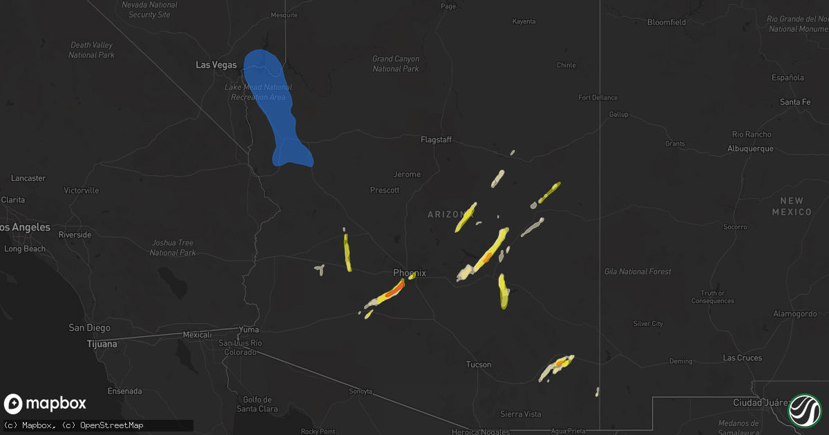
Hail Map in Arizona on October 5, 2021
Get this storm
October 5 map
$229
one time, instant access
Download today. No call, no setup
Keep the $229
Bought the map and want the full workflow? Apply the entire $229 to a subscription within 7 days. None of it is wasted.
Every map, not just this one
This buys you this map. Subscription and you get every map we run, in the markets you choose from a few cities to whole states to nationwide. Plus real-time alerts the moment a storm fires.
Contact data
Name, contact info, occupancy, even credit band for addresses in the footprint. You go from where it hit to who to call.
Become the source they trust
Unlimited branding weather history reports on demand. You already have the documented answer ready for the property owner, and you are the one who showed up with it.
Property data and RoofTrace estimates
Pull up any address you have got, its value and the exact code rules for that jurisdiction, straight from One Click Code. Then RoofTrace estimates the squares, pitch, and roof value, priced the way you price.
Storm reports in Arizona
Arizona
| Date | Description |
|---|---|
| 10/05/20216:13 PM CDT | ***delayed report*** observer at gila bend airfield reported 1 inch hail in the metar. |
| 10/05/20214:28 PM CDT | Mesonet station au919 2 sse roosevelt. |
| 10/05/20214:05 PM CDT | ***slightly delayed report***mesonet station srp45 5.3 ne tortilla flat |
| 10/05/20213:37 PM CDT | ***delayed report***small tree limbs down. Wind speed reported 50 mph. |
| 10/05/20212:50 PM CDT | Tweeds point raws measured a gust to 58 mph at the 1333 hourly ob. Time of gust estimated to be 1250 by radar. |
| 10/05/202112:50 PM CDT | Trees and powerlines down across the city of kingman as reported by emergency manager. Time estimated from radar. |
| 10/05/202112:48 PM CDT | Kingman asos |
| 10/05/202112:48 PM CDT | Winds in excess of 58 mph began at kingman airport at 1048 and continue to gust above severe thresholds. Peak wind gust 68 mph. |
| 10/05/202112:30 PM CDT | Reports of severe thunderstorm related wind damage just north of wikieup. Multiple heavy duty command tents knocked down as well as every porta potty on site. |
| 10/05/202112:12 PM CDT | Cwop in yucca arizona measured 59 mph thunderstorm related wind gusts from 1012 to 1017. |
| 10/05/20217:54 AM CDT | At 1254 PM MST, a severe thunderstorm was located over Dragoon, or 18 miles southwest of Willcox, moving northeast at 20 mph. HAZARD...60 mph wind gusts and quarter size hail. SOURCE...Radar indicated. IMPACT...Hail damage to vehicles is expected. Expect wind damage to roofs, siding, and trees. Locations impacted include... Dragoon and Cochise. |
| 10/05/20217:41 AM CDT | At 1240 PM PDT/1240 PM MST/, a severe thunderstorm was located over Lake Mead National Recreation Area, moving north at 25 mph. HAZARD...60 mph wind gusts. SOURCE...Radar indicated. IMPACT...Expect damage to roofs and trees. Locations impacted include... Boulder City, Las Vegas Bay, Overton, Moapa Valley, Echo Bay, Boulder Beach, Grand Canyon Skywalk, Boulder Beach Campground, Echo Bay Campground, Callville Bay, Meadview, Hoover Dam, Valley Of Fire, Callville Bay Campground, Lake Mead National Recreation Area, Temple Bar Campground, Overton Beach, South Cove, Logandale and Las Vegas Bay Campground. |
| 10/05/20216:42 AM CDT | At 1139 AM PDT/1139 AM MST/, a line of severe thunderstorms were located 13 miles southwest of Lake Mead National Recreation Area, or 25 miles east of Boulder City, moving north at 45 mph. HAZARD...70 mph wind gusts. SOURCE...Radar indicated. IMPACT...Expect considerable tree damage. Damage is likely to mobile homes, roofs, and outbuildings. Locations impacted include... Boulder City, Las Vegas Bay, Overton, Moapa Valley, Echo Bay, Grand Canyon Skywalk, Boulder Beach Campground, Las Vegas Bay Campground, Pierce Ferry And Antares Roads, Meadview, Hoover Dam, Temple Bar Campground, South Cove, Logandale, Boulder Beach, Echo Bay Campground, Callville Bay, Grand Canyon Ranch, Valley Of Fire and Callville Bay Campground. |
| 10/05/20212:38 AM CDT | At 737 PM MST, a severe thunderstorm was located 16 miles south of Salome, or 33 miles west of Tonopah, moving northeast at 25 mph. HAZARD...60 mph wind gusts and quarter size hail. SOURCE...Radar indicated. IMPACT...Hail damage to vehicles is expected. Expect wind damage to roofs, siding, and trees. This severe thunderstorm will remain over mainly rural areas of east central La Paz and Maricopa Counties.This includes the following highways...AZ Interstate 10 between mile markers 56 and 74.US Highway 60 between mile markers 67 and 74. |
| 10/05/20211:00 AM CDT | At 559 PM MST, a severe thunderstorm was located over South Phoenix, or near Laveen, moving northeast at 25 mph. HAZARD...60 mph wind gusts and quarter size hail. SOURCE...Radar indicated. IMPACT...Hail damage to vehicles is expected. Expect wind damage to roofs, siding, and trees. Locations impacted include... Phoenix, Mesa, Scottsdale, Tempe, Paradise Valley, Laveen, Mesa Riverview Mall, Tempe Marketplace, Papago Park, Piestewa Peak Park, Arizona Mills Mall, Salt River Indian Community, Downtown Mesa, South Phoenix and Arizona State Fairgrounds.This includes the following highways...AZ Interstate 10 between mile markers 142 and 159.AZ Interstate 17 between mile markers 195 and 202.AZ Route 51 between mile markers 1 and 14. |
| 10/05/202112:41 AM CDT | At 541 PM MST, a severe thunderstorm was located 14 miles southeast of Aguila, or 19 miles northwest of Tonopah, moving north at 30 mph. HAZARD...60 mph wind gusts and quarter size hail. SOURCE...Radar indicated. IMPACT...Hail damage to vehicles is expected. Expect wind damage to roofs, siding, and trees. Locations impacted include... Aguila.This includes US Highway 60 between mile markers 82 and 97. |
| 10/05/202112:26 AM CDT | At 525 PM MST, a severe thunderstorm was located 9 miles north of Bowie, or 22 miles northeast of Willcox, moving northeast at 20 mph. HAZARD...60 mph wind gusts and half dollar size hail. SOURCE...Radar indicated. IMPACT...Hail damage to vehicles is expected. Expect wind damage to roofs, siding, and trees. This severe thunderstorm will remain over mainly remote areas of southeastern Graham and northeastern Cochise Counties. |
| 10/05/202112:24 AM CDT | At 524 PM MST, a severe thunderstorm was located 13 miles south of San Carlos, or 13 miles northeast of Christmas, moving north at 25 mph. HAZARD...60 mph wind gusts and quarter size hail. SOURCE...Radar indicated. IMPACT...Hail damage to vehicles is expected. Expect wind damage to roofs, siding, and trees. Locations impacted include... San Carlos.This includes AZ Route 70 between mile markers 261 and 271. |
| 10/05/202112:19 AM CDT | At 518 PM MST, a severe thunderstorm was located 10 miles south of Estrella Mountain Park, or 16 miles south of Avondale, moving east at 35 mph. HAZARD...Two inch hail and 60 mph wind gusts. SOURCE...Radar indicated. IMPACT...People and animals outdoors will be injured. Expect hail damage to roofs, siding, windows, and vehicles. Expect wind damage to roofs, siding, and trees. Locations impacted include... Phoenix, Chandler, Avondale, Goodyear, Sun Lakes, South Mountain Park, Bapchule, South Phoenix, Rainbow Valley, Firebird Lake, Santan and Komatke.This includes the following highways...AZ Interstate 10 between mile markers 159 and 174.AZ Route 87 between mile markers 155 and 160.AZ Route 202 between mile markers 53 and 55. |
| 10/05/202112:18 AM CDT | At 517 PM MST, a severe thunderstorm was located west of Rodeo, moving north at 15 mph. HAZARD...60 mph wind gusts and quarter size hail. SOURCE...Radar indicated. IMPACT...Hail damage to vehicles is expected. Expect wind damage to roofs, siding, and trees. Locations impacted include... Portal. |
| 10/05/202112:06 AM CDT | At 505 PM MST, a severe thunderstorm was located 9 miles north of Aravaipa Canyon Wilderness, or 10 miles east of Christmas, moving northeast at 15 mph. HAZARD...60 mph wind gusts and quarter size hail. SOURCE...Radar indicated. IMPACT...Hail damage to vehicles is expected. Expect wind damage to roofs, siding, and trees. Locations impacted include... San Carlos Reservoir. |
| 10/05/202112:05 AM CDT | At 505 PM MST, a severe thunderstorm was located near Tonopah, moving north at 40 mph. HAZARD...60 mph wind gusts and quarter size hail. SOURCE...Radar indicated. IMPACT...Hail damage to vehicles is expected. Expect wind damage to roofs, siding, and trees. Locations impacted include... Tonopah.This includes AZ Interstate 10 between mile markers 84 and 97. |
| 10/04/202111:49 PM CDT | At 449 PM MST, a severe thunderstorm was located near Shumway, or 7 miles north of Show Low, moving northeast at 20 mph. HAZARD...60 mph wind gusts and half dollar size hail. SOURCE...Radar indicated. IMPACT...Hail damage to vehicles is expected. Expect wind damage to roofs, siding, and trees. Locations impacted include... Show Low, Shumway, Wagon Wheel, Fool Hollow Lake Campground and White Mountain Lake. |
| 10/04/202111:41 PM CDT | At 441 PM MST, a severe thunderstorm was located near Cotton Center, or 9 miles northeast of Gila Bend, moving northeast at 20 mph. HAZARD...60 mph wind gusts and half dollar size hail. SOURCE...Radar indicated. IMPACT...Hail damage to vehicles is expected. Expect wind damage to roofs, siding, and trees. Locations impacted include... Avondale, Goodyear, Buckeye, Bosque, Cotton Center, Estrella Mountain Ranch and Rainbow Valley.This includes the following highways...AZ Route 238 between mile markers 3 and 13.AZ Route 85 between mile markers 123 and 144. |
| 10/04/202111:34 PM CDT | At 434 PM MST, a severe thunderstorm was located near San Carlos, or 21 miles northeast of Christmas, moving northeast at 20 mph. HAZARD...60 mph wind gusts and quarter size hail. SOURCE...Radar indicated. IMPACT...Hail damage to vehicles is expected. Expect wind damage to roofs, siding, and trees. Locations impacted include... San Carlos.This includes AZ Route 70 between mile markers 266 and 271. |
| 10/04/202111:31 PM CDT | At 430 PM MST, a severe thunderstorm was located 12 miles southwest of Yava, or 30 miles northwest of Wickenburg, moving northeast at 45 mph. HAZARD...60 mph wind gusts and quarter size hail. SOURCE...Radar indicated. IMPACT...Hail damage to vehicles is expected. Expect wind damage to roofs, siding, and trees. Locations impacted include... Yava and Kirkland. |
| 10/04/202111:18 PM CDT | At 417 PM MST, a severe thunderstorm was located 14 miles southwest of Carrizo, or 35 miles southwest of Show Low, moving northeast at 30 mph. HAZARD...60 mph wind gusts and half dollar size hail. SOURCE...Radar indicated. IMPACT...Hail damage to vehicles is expected. Expect wind damage to roofs, siding, and trees. This severe thunderstorm will remain over mainly rural areas of Gila County.This includes US Highway 60 between mile markers 289 and 298. |
| 10/04/202111:18 PM CDT | At 417 PM MST, a severe thunderstorm was located near and 8 miles southeast of San Carlos, or 25 miles east of Globe, moving northeast at 20 mph. HAZARD...60 mph wind gusts and quarter size hail. SOURCE...Radar indicated. IMPACT...Hail damage to vehicles is expected. Expect wind damage to roofs, siding, and trees. This severe thunderstorm will remain over mainly remote areas of northwestern Graham County. |
| 10/04/202111:06 PM CDT | At 405 PM MST, a severe thunderstorm was located 7 miles northwest of Gila Bend Auxiliary Field, or 9 miles west of Gila Bend, moving northeast at 25 mph. HAZARD...60 mph wind gusts and quarter size hail. SOURCE...Radar indicated. IMPACT...Hail damage to vehicles is expected. Expect wind damage to roofs, siding, and trees. Locations impacted include... Gila Bend, Cotton Center and Gila Bend Auxiliary Field. This includes the following highways...AZ Interstate 8 between mile markers 101 and 119.AZ Route 238 between mile markers 1 and 2.AZ Route 85 between mile markers 1 and 10, and between mile markers119 and 134. |
| 10/04/202110:38 PM CDT | At 338 PM MST, a severe thunderstorm was located near and southwest of Davis-Monthan Air Force Base, moving northeast at 25 mph. HAZARD...60 mph wind gusts and quarter size hail. SOURCE...Radar indicated. IMPACT...Hail damage to vehicles is expected. Expect wind damage to roofs, siding, and trees. Locations impacted include... Tucson, Catalina, Davis-Monthan Air Force Base, Tanque Verde, Mount Lemmon/Summerhaven, Sabino Canyon Recreation Area, Catalina Foothills, Tucson International Airport, Saguaro National Park East, Rita Ranch. |
| 10/04/202110:30 PM CDT | At 330 PM MST, a severe thunderstorm was located 14 miles west of Carrizo, or 25 miles southeast of Forest Lakes, moving northeast at 35 mph. HAZARD...Two inch hail and 60 mph wind gusts. SOURCE...Radar indicated. IMPACT...People and animals outdoors will be injured. Expect hail damage to roofs, siding, windows, and vehicles. Expect wind damage to roofs, siding, and trees. Locations impacted include... Cibecue. |
| 10/04/202110:23 PM CDT | At 322 PM MST, a severe thunderstorm was located near Bowie, or 17 miles east of Willcox, moving northeast at 20 mph. HAZARD...70 mph wind gusts and ping pong ball size hail. SOURCE...Radar indicated. IMPACT...People and animals outdoors will be injured. Expect hail damage to roofs, siding, windows, and vehicles. Expect considerable tree damage. Wind damage is also likely to mobile homes, roofs, and outbuildings. Locations impacted include... Bowie. |
| 10/04/20219:50 PM CDT | At 250 PM MST, a severe thunderstorm was located 19 miles east of Tonto National Monument, or 19 miles east of Roosevelt, moving northeast at 40 mph. HAZARD...Two inch hail and 60 mph wind gusts. SOURCE...Radar indicated. IMPACT...People and animals outdoors will be injured. Expect hail damage to roofs, siding, windows, and vehicles. Expect wind damage to roofs, siding, and trees. This severe thunderstorm will remain over mainly rural areas of Gila County.This includes US Highway 60 between mile markers 286 and 297. |
| 10/04/20219:48 PM CDT | At 248 PM MST, a severe thunderstorm was located 9 miles southeast of Willcox, moving northeast at 20 mph. HAZARD...60 mph wind gusts and quarter size hail. SOURCE...Radar indicated. IMPACT...Hail damage to vehicles is expected. Expect wind damage to roofs, siding, and trees. Locations impacted include... Willcox, Bowie, Pearce-Sunsites and Kansas Settlement. |
| 10/04/20219:47 PM CDT | At 246 PM MST, a severe thunderstorm was located 17 miles east of Tonto National Monument, or 18 miles east of Roosevelt, moving northeast at 35 mph. HAZARD...Two inch hail and 60 mph wind gusts. SOURCE...Radar indicated. IMPACT...People and animals outdoors will be injured. Expect hail damage to roofs, siding, windows, and vehicles. Expect wind damage to roofs, siding, and trees. This severe thunderstorm will remain over mainly rural areas of Gila County. |
| 10/04/20219:12 PM CDT | At 212 PM MST, severe thunderstorms were located along a line extending from Round Valley to near Four Peaks to 6 miles south of Tonto National Monument to 6 miles north of Top-Of-The-World, moving northeast at 40 mph. HAZARD...60 mph wind gusts and half dollar size hail. SOURCE...Radar indicated. IMPACT...Hail damage to vehicles is expected. Expect wind damage to roofs, siding, and trees. Locations impacted include... Round Valley, Sugarloaf Mountain, Sycamore Creek, Ballantine Trailhead, Sunflower, Roosevelt, Miami, Punkin Center, Roosevelt Dam, Top-Of-The-World, Tonto Basin, Tonto National Monument, Four Peaks, Apache Lake and Inspiration.This includes the following highways...US Highway 60 between mile markers 230 and 242, and between milemarkers 264 and 266.AZ Route 87 between mile markers 202 and 229.AZ Route 188 between mile markers 217 and 266. |
| 10/04/20219:08 PM CDT | At 207 PM MST, a severe thunderstorm was located over Kohls Ranch, or 14 miles east of Payson, moving northeast at 25 mph. HAZARD...Quarter size hail. SOURCE...Radar indicated. IMPACT...Damage to vehicles is expected. Locations impacted include... Christopher Creek, Tonto Village, Kohls Ranch, Hunter Creek, Mead Ranch, Forest Road 169 Campground, Bear Flat, Upper Tonto Creek Campground, Knoll Lake Campground, Spillway Campground, Ponderosa Campground, Sharp Creek Campground, Forest Road 195 Campground, Mogollon Campground, Forest Road 9350 Campground, Promontory Pit Road Campground, Christopher Creek Campground, Woods Canyon Lake Campground and Crook Campground. |
| 10/04/20218:58 PM CDT | At 158 PM MST, severe thunderstorms were located along a line extending from near Saguaro Lake to near Canyon Lake to 6 miles southwest of Apache Lake, moving northeast at 40 mph. HAZARD...60 mph wind gusts and quarter size hail. SOURCE...Radar indicated. IMPACT...Hail damage to vehicles is expected. Expect wind damage to roofs, siding, and trees. Locations impacted include... Four Peaks, Saguaro Lake, Canyon Lake, Apache Lake, Tonto Basin and Tortilla Flat.This includes AZ Route 188 between mile markers 252 and 254. |
| 10/04/20218:58 PM CDT | At 158 PM MST, a severe thunderstorm was located 8 miles west of Bowie, or 12 miles east of Willcox, moving northeast at 20 mph. HAZARD...70 mph wind gusts and ping pong ball size hail. SOURCE...Radar indicated. IMPACT...People and animals outdoors will be injured. Expect hail damage to roofs, siding, windows, and vehicles. Expect considerable tree damage. Wind damage is also likely to mobile homes, roofs, and outbuildings. Locations impacted include... Bowie. |
| 10/04/20218:35 PM CDT | At 135 PM MST, severe thunderstorms were located along a line extending from near Gold Canyon to Florence Junction to 9 miles south of Queen Valley, moving east at 35 mph. HAZARD...60 mph wind gusts and quarter size hail. SOURCE...Radar indicated. IMPACT...Hail damage to vehicles is expected. Expect wind damage to roofs, siding, and trees. Locations impacted include... Mesa, Apache Junction, Superior, Gold Canyon, Gold Camp, Lost Dutchman State Park, Goldfield, Top-Of-The-World, Florence Junction, Queen Valley, Superstition Mountains, Kings Ranch, Apache Lake and Boyce Thompson Arboretum.This includes the following highways...US Highway 60 between mile markers 192 and 242.AZ Route 77 between mile markers 154 and 162.AZ Route 79 between mile markers 140 and 150. |
| 10/04/20218:27 PM CDT | At 127 PM MST, a severe thunderstorm was located near Willcox, moving northeast at 20 mph. HAZARD...60 mph wind gusts and quarter size hail. SOURCE...Radar indicated. IMPACT...Hail damage to vehicles is expected. Expect wind damage to roofs, siding, and trees. Locations impacted include... Willcox and Cochise. |
| 10/04/20218:24 PM CDT | At 123 PM MST, a severe thunderstorm was located near Gisela, or 13 miles south of Payson, moving northeast at 20 mph. HAZARD...Quarter size hail. SOURCE...Radar indicated. IMPACT...Damage to vehicles is expected. Locations impacted include... Payson, Star Valley, Oxbow Estates, Round Valley, Flowing Springs, Mesa Del Caballo, Gisela, Freedom Acres, Jakes Corner, Rye, Houston Mesa Campground, Water Wheel Burn At Houston Mesa Rd- S, Beaver Valley, Water Wheel Burn At Houston Mesa Rd- N, Deer Creek and Alderwood Campground. |
| 10/04/20218:05 PM CDT | ***delayed report*** photo on social media of hail stones estimated up to 1.25 inches in diameter. Location and timing based on radar. |
| 10/04/20218:04 PM CDT | Video on social media of a collection of hail with the largest stones estimated around 1 inch. |
| 10/04/20218:04 PM CDT | Social media photo from local journalist showed hail in his hand. He estimated the size at 1.5 inches in diameter. Hail fell for around 5 minutes. |
| 10/04/20218:02 PM CDT | Photo on social media of a 1 inch diameter hail stone. |
| 10/04/20218:00 PM CDT | At 100 PM MST, a severe thunderstorm was located over Sunflower, moving north at 35 mph. HAZARD...Quarter size hail. SOURCE...Radar indicated. IMPACT...Damage to vehicles is expected. Locations impacted include... Round Valley, Sycamore Creek, Sunflower, Punkin Center and Tonto Basin.This includes the following highways...AZ Route 87 between mile markers 212 and 229.AZ Route 188 between mile markers 260 and 266. |
| 10/04/20217:46 PM CDT | ***delayed report*** storm chaser reported estimated 1 inch hail while driving on loop-202. |
| 10/04/20217:30 PM CDT | Persistent large hail reported. |
All States Impacted by Hail Map on October 5, 2021
Cities Impacted by Hail Map on October 5, 2021
- Winslow, AZ
- Superior, AZ
- Congress, AZ
- Watson, AR
- Willcox, AZ
- Marianna, AR
- Clarksdale, MS
- Crawford, MS
- Brooksville, MS
- Peridot, AZ
- Helena, AR
- Coahoma, MS
- Louisville, MS
- Carthage, MS
- Wickenburg, AZ
- Carrollton, MS
- Greenwood, MS
- Holcomb, MS
- Young, AZ
- Globe, AZ
- De Witt, AR
- Gillett, AR
- McCool, MS
- Noxapater, MS
- Payson, AZ
- Roosevelt, AZ
- Gila Bend, AZ
- Lexa, AR
- Buckeye, AZ
- Hollandale, MS
- Tunica, MS
- San Simon, AZ
- Cochise, AZ
- Steens, MS
- Starkville, MS
- Sturgis, MS
- Philadelphia, MS
- Millport, AL
- Columbus, MS
- Caledonia, MS
- Sulligent, AL
- Hampton, AR
- Junction City, AR
- Kosciusko, MS
- Crystal Springs, MS
- Hazlehurst, MS
- Belzoni, MS
- Smithdale, MS
- Concho, AZ
- Forest Lakes, AZ
- Rosedale, MS
- Moro, AR
- Aberdeen, MS
- West Point, MS
- Greenville, MS
- Montrose, AR
- Laveen, AZ
- Fountain Hill, AR
- Hermitage, AR
- Tchula, MS
- Dundee, MS
- Huttig, AR
- Phoenix, AZ
- Crossett, AR
- Macon, MS
- Lakeside, AZ
- Show Low, AZ
- Fort Mcdowell, AZ
- Tonto Basin, AZ
- Lancaster, VA
- Irvington, VA
- White Stone, VA
- Weems, VA
- Tonopah, AZ
- Clarendon, AR
- Choudrant, LA
- Downsville, LA
- Bowie, AZ
- Vernon, AL
- Strong, AR
- Stuttgart, AR
- Pinetop, AZ
- Preston, MS
- Gould, AR
- Coffeeville, MS
- El Dorado, AR
- Calhoun City, MS
- Snowflake, AZ
- Dumas, AR
- Grady, AR
- Taylor, AZ
- Lake Village, AR
- Heber, AZ
- Salome, AZ
- Meadview, AZ
- Overton, NV
- Kingman, AZ
- Dolan Springs, AZ
- Chloride, AZ
- Golden Valley, AZ
- Bullhead City, AZ
- Yucca, AZ
- Willow Beach, AZ
- Winkelman, AZ
- Jackson, MS


