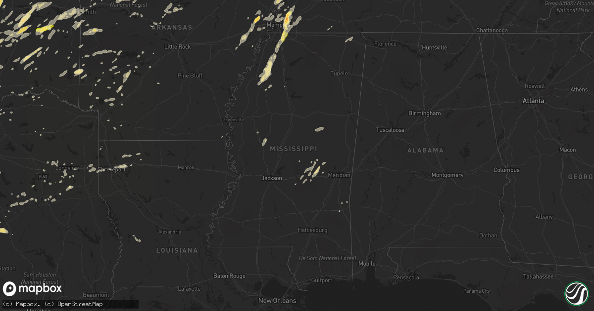
Hail Map in Mississippi on October 2, 2014
Get this storm
October 2 map
$229
one time, instant access
Download today. No call, no setup
Keep the $229
Bought the map and want the full workflow? Apply the entire $229 to a subscription within 7 days. None of it is wasted.
Every map, not just this one
This buys you this map. Subscription and you get every map we run, in the markets you choose from a few cities to whole states to nationwide. Plus real-time alerts the moment a storm fires.
Contact data
Name, contact info, occupancy, even credit band for addresses in the footprint. You go from where it hit to who to call.
Become the source they trust
Unlimited branding weather history reports on demand. You already have the documented answer ready for the property owner, and you are the one who showed up with it.
Property data and RoofTrace estimates
Pull up any address you have got, its value and the exact code rules for that jurisdiction, straight from One Click Code. Then RoofTrace estimates the squares, pitch, and roof value, priced the way you price.
Storm reports in Mississippi
Mississippi
| Date | Description |
|---|---|
| 10/02/20146:25 PM CDT | Tree down on 37th st. Rd crew had to remove the tree. |
| 10/02/20145:45 PM CDT | Trees downed. Tree across scalin rd at strum rd |
| 10/02/20145:40 PM CDT | Very strong winds were also reported |
| 10/02/20145:32 PM CDT | Tree down across salem rd. |
| 10/02/20145:00 PM CDT | Numerous trees down along interstate 20 just east of brandon. Reported by nws employee |
| 10/02/20144:45 PM CDT | Four trees down on lebanon road. Reported by emergency management. |
| 10/02/20143:51 PM CDT | Spotter reported heavy downpour with quarter sized hail. |
| 10/02/20143:45 PM CDT | Large tree limbs down in nesbit area. Church road blocked with numerous large limbs. Pea sized hail also falling. |
| 10/02/20143:45 PM CDT | Wind gust of 63 mph recorded. |
| 10/02/20143:00 AM CDT | Porch rolled up on a house...destroying the porch and causing damage to the home. Also numerous trees down. Reported by emergency manager |
| 10/02/20142:00 AM CDT | Large limbs were blown down...one limb broke a window |
| 10/02/20141:05 AM CDT | Twelve trees down in the southeast part of the county near rosebud. Power was interrupted in east carthage and along highway 487 east. Reported by emergency management |
| 10/02/201412:40 AM CDT | Trees down across town. |
| 10/02/201412:30 AM CDT | Trees down along county road 1766 |
| 10/02/201412:10 AM CDT | Pea sized hail and one tree on a house in the city limits. |
| 10/02/201412:05 AM CDT | Large trees down and blocking road on cr-59 off 30 west. |
| 10/02/201412:00 AM CDT | Trees reported down...possible microburst. |
| 10/01/201411:55 PM CDT | Damage occurred to a building at the yazoo planters gin. Sheet metal and some beams were damaged...and module covers were blown off. |
| 10/01/201411:00 PM CDT | Several trees down. |
| 10/01/201410:39 PM CDT | Trees snapped and large branches down on highway 4 13 miles west of senatobia. |
| 10/01/201410:30 PM CDT | Possible tornado damage to strayhorn elementary school. |
| 10/01/201410:10 PM CDT | Damage throughout tunica county... Including damage to mobile homes and minor damages to a farm shop and two houses |
| 10/01/20149:25 PM CDT | *** 1 inj *** mobile home was rolled onto its side into several trees with debris blown down wind. Wind speed estimated 75 to 85 mph. Several large limbs in nearby tree |
| 10/01/20147:12 PM CDT | Wayne county emergency management reports two trees down in the matherville community. |
All States Impacted by Hail Map on October 2, 2014
Cities Impacted by Hail Map on October 2, 2014
- Pryor, OK
- Adair, OK
- Porter, OK
- Earle, AR
- Ackerman, MS
- McCool, MS
- Weir, MS
- Louisville, MS
- Forrest City, AR
- Palestine, AR
- Haynes, AR
- Marianna, AR
- Mounds, OK
- Glenpool, OK
- Eureka Springs, AR
- Mountain Home, AR
- Clayton, OK
- Decatur, TX
- Okemah, OK
- Okmulgee, OK
- Clarksville, AR
- Gentry, AR
- Thornfield, MO
- Lipan, TX
- Parkin, AR
- Lampasas, TX
- Aledo, TX
- Fort Worth, TX
- Arlington, TX
- Naval Air Station Jrb, TX
- Jay, OK
- Colcord, OK
- Owasso, OK
- Tulsa, OK
- Claremore, OK
- Collinsville, OK
- Oologah, OK
- Cordova, TN
- Olive Branch, MS
- Nesbit, MS
- Millington, TN
- Memphis, TN
- Southaven, MS
- Arlington, TN
- Hernando, MS
- Rock, KS
- Winfield, KS
- Concordia, KS
- Sumner, IL
- Robinson, IL
- Oblong, IL
- Dyer, AR
- Alma, AR
- Mulberry, AR
- Seminole, OK
- Wewoka, OK
- Rhome, TX
- Oldfield, MO
- Seymour, MO
- Chadwick, MO
- Garrison, MO
- Ava, MO
- Clearwater, KS
- Haysville, KS
- Wichita, KS
- Mcconnell Afb, KS
- Welling, OK
- Kansas, OK
- Proctor, OK
- Hulbert, OK
- Muskogee, OK
- Park Hill, OK
- Tahlequah, OK
- Watts, OK
- Westville, OK
- Fort Gibson, OK
- Maysville, AR
- Wesley, AR
- Huntsville, AR
- Cedar Vale, KS
- Elk City, KS
- Sedan, KS
- Elk Falls, KS
- Moline, KS
- Fredonia, KS
- Longton, KS
- Ponder, TX
- Justin, TX
- Blue Rapids, KS
- Vermillion, KS
- Frankfort, KS
- Clyde, KS
- Palmer, KS
- Clifton, KS
- Linn, KS
- Montrose, MO
- Deepwater, MO
- Clinton, MO
- De Soto, MO
- Elkins, AR
- Nashoba, OK
- Lewisville, AR
- Rockwall, TX
- Rowlett, TX
- Mesquite, TX
- Garland, TX
- Dallas, TX
- Sunnyvale, TX
- Waxahachie, TX
- Fairview, KS
- Baileyville, KS
- Goff, KS
- Seneca, KS
- Sabetha, KS
- Corning, KS
- Centralia, KS
- Broken Arrow, OK
- Decatur, MS
- Mineral Point, MO
- Bonne Terre, MO
- Pinckneyville, IL
- Tamaroa, IL
- Clifton, TX
- Sanger, TX
- Valley View, TX
- Alvord, TX
- Era, TX
- Gainesville, TX
- Rosston, TX
- Thackerville, OK
- Ardmore, OK
- Lena, MS
- Lockhart, TX
- Dexter, KS
- Girard, KS
- Belton, TX
- Kellyville, OK
- Bristow, OK
- Sheldon, IL
- Belleview, MO
- Ironton, MO
- Middle Brook, MO
- Allen, OK
- Fitzhugh, OK
- Ada, OK
- Stonewall, OK
- Fittstown, OK
- Mcalester, OK
- Marlin, TX
- Coweta, OK
- Paris, AR
- Hope, AR
- Madill, OK
- Eddy, TX
- Bruceville, TX
- Theodosia, MO
- Rueter, MO
- Millstadt, IL
- Marshall, TX
- Waskom, TX
- Mountain Grove, MO
- Amity, AR
- Kingston, OK
- Marietta, OK
- Lebanon, OK
- Thornton, TX
- Franklin, TX
- Marquez, TX
- Jewett, TX
- Kosse, TX
- Centerville, TX
- Vance, MS
- El Dorado, KS
- Elk Creek, MO
- Willow Springs, MO
- Yukon, MO
- Delaware, AR
- Malvern, AR
- Reagan, TX
- Salem, MO
- Forest, MS
- Kentland, IN
- Bradleyville, MO
- Keota, OK
- Spiro, OK
- Aquilla, TX
- Whitney, TX
- Valley Mills, TX
- Smithton, MO
- Sedalia, MO
- Mora, MO
- Sullivan, MO
- Bourbon, MO
- Freeburg, MO
- Donie, TX
- Groesbeck, TX
- Lesterville, MO
- Annapolis, MO
- Wynona, OK
- Barnsdall, OK
- Hominy, OK
- Catoosa, OK
- Henderson, TX
- Mill Creek, OK
- Tishomingo, OK
- Overton, TX
- Coleman, OK
- Atoka, OK
- Conway Springs, KS
- Roanoke, TX
- Dale, TX
- Holdenville, OK
- Minden, LA
- Cotton Valley, LA
- Garwood, TX
- Powell, MO
- Pineville, MO
- Sallisaw, OK
- Muldrow, OK
- Roland, OK
- Stuart, OK
- Calvin, OK
- Aurora, KS
- Greenleaf, KS
- Fulton, AR
- Washington, AR
- Delight, AR
- Denton, TX
- Gerald, MO
- Success, MO
- Poteet, TX
- Granbury, TX
- Weatherford, TX
- Galesburg, KS
- Thayer, KS
- Independence, KS
- Cherryvale, KS
- Union, MS
- Conehatta, MS
- Lawrence, MS
- Kopperl, TX
- Story, AR
- Sims, AR
- Stroud, OK
- Haskell, OK
- Bixby, OK
- Carthage, AR
- West Plains, MO
- Pomona, MO
- Pacific, MO
- Eureka, MO
- Edgar Springs, MO
- Licking, MO
- Muenster, TX
- Flippin, AR
- Yellville, AR
- Eminence, MO
- Indianola, OK
- Hanna, OK
- Eufaula, OK
- Cameron, OK
- Quenemo, KS
- Pomona, KS
- Ottawa, KS
- Ridgedale, MO
- Protem, MO
- Oak Grove, AR
- Wasola, MO
- Kirbyville, MO
- Kissee Mills, MO
- Omaha, AR
- Noble, MO
- Hollister, MO
- Green Forest, AR
- Cedarcreek, MO
- Bremond, TX
- Sasakwa, OK
- McLean, IL
- Atlanta, IL
- Wolfe City, TX
- Little Rock, MS
- Kinta, OK
- Quinton, OK
- Plato, MO
- Sand Springs, OK
- Broken Bow, OK
- Peggs, OK
- Locust Grove, OK
- Galena, MO
- Crane, MO
- Yale, OK
- Weleetka, OK
- Crenshaw, MS
- Sarah, MS
- Dundee, MS
- Forestburg, TX
- Haslet, TX
- Norman, AR
- Arthur City, TX
- Noel, MO
- Mccurtain, OK
- Watson, OK
- Wickes, AR
- Grannis, AR
- Dustin, OK
- Waco, TX
- Riesel, TX
- Hewitt, TX
- Woodway, TX
- Waterville, KS
- Longview, TX
- Neodesha, KS
- Altoona, KS
- Baldwin City, KS
- Lawrence, KS
- Saint Paul, KS
- Ennis, TX
- Hartville, MO
- Vinita, OK
- Checotah, OK
- Tuskahoma, OK
- Antlers, OK
- Marks, MS
- Sledge, MS
- Lambert, MS
- Lane, OK
- Hallsville, TX
- Garfield, AR
- Bentonville, AR
- Centerton, AR
- Rogers, AR
- Seligman, MO
- Siloam Springs, AR
- Pea Ridge, AR
- Liberty, KS
- Thrall, TX
- Warner, OK
- Cresson, TX
- Lorena, TX
- Chilton, TX
- Loco, OK
- Duncan, OK
- Waurika, OK
- Vanzant, MO
- Red Oak, TX
- Park Hills, MO
- Bismarck, MO
- Piedmont, MO
- Norwood, MO
- Bunch, OK
- Wortham, TX
- Streetman, TX
- Roff, OK
- Wagoner, OK
- Crawfordsville, AR
- Smithville, OK
- Haughton, LA
- Dover, AR
- Andover, KS
- Red Rock, TX
- Crawford, TX
- Jonesboro, TX
- Oglesby, TX
- Gatesville, TX
- McGregor, TX
- Mart, TX
- Moody, TX
- Eureka, KS
- Barnes, KS
- Nowata, OK
- Chestnutridge, MO
- Walnut Shade, MO
- Ozark, MO
- Forsyth, MO
- Dierks, AR
- Meridian, TX
- Wilson, AR
- Bunker, MO
- Centerville, MO
- Ellington, MO
- Sparta, MO
- Linn, MO
- Springtown, TX
- Paradise, TX
- Coalgate, OK
- Hodgen, OK
- Cuba, MO
- Madison, KS
- Hamilton, KS
- Henning, TN
- Ripley, TN
- Howe, TX
- Sherman, TX
- Azle, TX
- Oakwood, TX
- Fairfield, TX
- Marshall, IL
- West Union, IL
- Benton, KS
- Bismarck, AR
- Tutwiler, MS
- Willow City, TX
- Fredericksburg, TX
- Asher, OK
- Newark, TX
- Keller, TX
- Athens, LA
- Homer, LA
- Hillsboro, TX
- Morgan, TX
- Parsons, KS
- Ringling, OK
- Ratliff City, OK
- Tussy, OK
- Hennepin, OK
- Comanche, OK
- Hubbard, TX
- Krebs, OK
- Flower Mound, TX
- Floresville, TX
- San Antonio, TX
- Adkins, TX
- Aubrey, TX
- Lake, MS
- La Vernia, TX
- Saint Louis, MO
- Fenton, MO
- Prosper, TX
- Krum, TX
- Celina, TX
- Gillham, AR
- Palestine, TX
- Purdon, TX
- Dawson, TX
- Pawnee, IL
- Farmersville, IL
- Harvel, IL
- Morrisonville, IL
- Hagarville, AR
- Ozone, AR
- Hartman, AR
- Oark, AR
- Cranfills Gap, TX
- Gassville, AR
- Cotter, AR
- Norfork, AR
- Hindsville, AR
- Springdale, AR
- Fayetteville, AR
- West Fork, AR
- Abbott, TX
- Depew, OK
- Wetumka, OK
- Heth, AR
- Sibley, LA
- Doyline, LA
- Tyler, TX
- Laneville, TX
- Summersville, MO
- Red Oak, OK
- Wilburton, OK
- Cabool, MO
- Osceola, AR
- High Ridge, MO
- House Springs, MO
- Catawissa, MO
- Robertsville, MO
- Coolidge, TX
- Poteau, OK
- Skiatook, OK
- Saint Clair, MO
- Yazoo City, MS
- Tchula, MS
- Hawk Point, MO
- Saint James, MO
- Mckinney, TX
- Blue Ridge, TX
- Jacksonville, TX
- Powderly, TX
- Ashdown, AR
- Waynesboro, MS
- West, TX
- Westphalia, MO
- Honobia, OK
- Hugo, OK
- Dennis, KS
- Welch, OK
- Llano, TX
- Melissa, TX
- Princeton, TX
- Wardville, OK
- Hot Springs Village, AR
- Palmer, TX
- Ferris, TX
- Middleton, TN
- Lonsdale, AR
- Cole Camp, MO
- Ionia, MO
- Lincoln, MO
- Marysville, KS
- Morrill, KS
- Morganville, KS
- Home, KS
- Hiawatha, KS
- Oneida, KS
- Coffeyville, KS
- Compton, AR
- Jasper, AR
- Ponca, AR
- Terre Haute, IN
- Udall, KS
- Berryville, AR
- West York, IL
- Martinsville, IL
- Burneyville, OK
- Du Quoin, IL
- Beggs, OK
- Corinth, MS
- Glen, MS
- Rienzi, MS
- Detroit, TX
- Cedar Creek, TX
- Hamilton, TX
- Evant, TX
- Cushing, OK
- Mannford, OK
- Drumright, OK
- Drummonds, TN
- Durant, OK
- Bokchito, OK
- Spavinaw, OK
- Tatum, TX
- Potosi, MO
- Steelville, MO
- Richards, MO
- Fort Scott, KS
- Huntington, AR
- Greenwood, AR
- Millsap, TX
- Rusk, TX
- Lockesburg, AR
- Milburn, OK
- Washburn, MO
- Decatur, AR
- Rocky Comfort, MO
- Bella Vista, AR
- Gravette, AR
- Sulphur Springs, AR
- Blevins, AR
- Prescott, AR
- Hawkins, TX
- Big Sandy, TX
- Manor, TX
- Shreveport, LA
- Axtell, KS
- Webbers Falls, OK
- Tupelo, OK
- Thayer, MO
- Morton, MS
- Pulaski, MS
- Kemp, TX
- Bee Branch, AR
- Damascus, AR
- Quitman, AR
- Clinton, AR
- Shirley, AR
- Coldwater, MS
- Atoka, TN
- Collierville, TN
- Brighton, TN
- Germantown, TN
- Eads, TN
- Marion, AR
- Senatobia, MS
- Oakland, TN
- Stratford, OK
- Moro, AR
- Widener, AR
- Madison, AR
- Anna, TX
- Van Alstyne, TX
- Argyle, TX
- Nevada, MO
- Redfield, KS
- Erie, KS
- Uniontown, KS
- Walnut, KS
- Havana, KS
- Hepler, KS
- Ozark, AR
- Kansas City, MO
- Del Valle, TX
- Austin, TX
- Bixby, MO
- Byars, OK
- Axtell, TX
- Mount Calm, TX
- Vassar, KS
- Overbrook, KS
- Waterloo, IL
- Murfreesboro, AR
- Boss, MO
- Drury, MO
- Haltom City, TX
- Frohna, MO
- Cedar Hill, MO
- Chandler, OK
- Aubrey, AR
- Gilmer, TX
- Gladewater, TX
- Owensville, MO
- Squires, MO
- Plattsburg, MO
- Valmeyer, IL
- Inola, OK
- Porum, OK
- Gore, OK
- Climax Springs, MO
- Russellville, AR
- Atwood, OK
- Whitesboro, TX
- Burns, KS
- Atlanta, KS
- Canehill, AR
- Evansville, AR
- Stilwell, OK
- Gans, OK
- Arkoma, OK
- Pocola, OK
- Van Buren, AR
- Fort Smith, AR
- Stigler, OK
- Walnut Springs, TX
- Glen Rose, TX
- Cape Fair, MO
- Aurora, MO
- Centrahoma, OK
- Pitkin, LA
- Fort Polk, LA
- Rich Hill, MO
- Rockville, MO
- Butler, MO
- Midlothian, TX
- Rockdale, TX
- Seguin, TX
- Fredericktown, MO
- Farmington, MO
- McCaskill, AR
- Wynnewood, OK
- Pauls Valley, OK
- Kenefic, OK
- Saint Jo, TX
- Lindsay, TX
- Eudora, AR
- Luling, TX
- Republic, MO
- Proctor, AR
- Pencil Bluff, AR
- Mount Ida, AR
- Frost, TX
- Kimberling City, MO
- Reeds Spring, MO
- Leasburg, MO
- Horatio, AR
- Osawatomie, KS
- Hatfield, AR
- Lonedell, MO
- Villa Ridge, MO
- Union, MO
- Saltillo, TX
- Winnsboro, TX
- Terrell, TX
- Anderson, MO
- Lamar, OK
- Honey Grove, TX
- Leesville, LA
- Mena, AR
- Caddo, OK
- Tennessee Colony, TX
- Talihina, OK
- Forreston, TX
- Itasca, TX
- Grandview, TX
- Italy, TX
- Milford, TX
- Winona, MO
- Stringtown, OK
- Wapanucka, OK
- Athens, TX
- Rolla, MO
- Cherryville, MO
- Bossier City, LA
- Barksdale Afb, LA
- Marshfield, MO
- Niangua, MO
- Conway, MO
- Ozan, AR
- Columbus, AR
- Saratoga, AR
- Trenton, TX
- Whitewright, TX
- Bonham, TX
- Randolph, TX
- Harrison, AR
- Penelope, TX
- Maud, OK
- Jenks, OK
- Chouteau, OK
- Boley, OK
- Sapulpa, OK
- Kiefer, OK
- Castle, OK
- Mount Olive, MS
- Bastrop, TX
- Mansfield, AR
- Booneville, AR
- Viola, KS
- Tillatoba, MS
- Oakland, MS
- Belzoni, MS
- Patton, MO
- Perryville, MO
- Langley, AR
- Glenwood, AR
- Kilgore, TX
- Flint, TX
- Chandler, TX
- Frankston, TX
- Mountain View, MO
- Appleton City, MO
- Schell City, MO
- Billings, MO
- Montalba, TX
- Turrell, AR
- Chanute, KS
- Munford, TN
- Grand Prairie, TX
- Paris, TX
- Blossom, TX
- McCune, KS
- Pottsboro, TX
- Gordonville, TX
- Sadler, TX
- Palmyra, IL
- Buffalo, TX
- Girard, IL
- Vivian, LA
- Black, MO
- Nashville, AR
- Newton, MS
- Cook Sta, MO
- Salina, OK
- Rose, OK
- Konawa, OK
- Walnut Grove, MS
- Branson, MO
- Walker, MO
- Cleveland, OK
- Jennings, OK
- Hico, TX
- Whitefield, OK
- Sulphur, OK
- Pine Hill, AL
- Lower Peach Tree, AL
- Taylor, TX
- Thorndale, TX
- Granger, TX
- Waldron, AR
- Rose Hill, KS
- Ochelata, OK
- Daisy, OK
- Redford, MO
- Moyers, OK
- Anacoco, LA
- Paris, IL
- Smithton, IL
- Hartford, AR
- Rattan, OK
- Snow, OK
- Augusta, KS
- Towanda, KS
- Lenapah, OK
- Wister, OK
- Cove, AR
- Savanna, OK
- Devine, TX
- Natalia, TX
- Hackett, AR
- Oswego, KS
- Caddo Gap, AR
- Troup, TX
- Kingston, AR
- Finley, OK
- Lepanto, AR
- Marked Tree, AR
- Springfield, AR
- Dana, IN
- Chrisman, IL
- S Coffeyville, OK
- Santo, TX
- Farmersville, TX
- Joiner, AR
- Effingham, IL
- Sulphur Springs, TX
- Nemo, TX
- Doe Run, MO
- Arcadia, MO
- Caledonia, MO
- Bland, MO
- Eagle Rock, MO
- Cassville, MO
- Burleson, TX
- Godley, TX
- Mansfield, TX
- Joshua, TX
- Kennedale, TX
- Crowley, TX
- Bonnerdale, AR
- Wellington, KS
- Oden, AR
- Eudora, KS
- Elmendorf, TX
- Davis, OK
- Sumner, TX
- Bennington, OK
- Louisville, IL
- Newton, IL
- Dieterich, IL
- Sibley, IL
- Henryetta, OK
- Okolona, AR
- Charleston, MS
- Texarkana, AR
- Fouke, AR
- Burnet, TX
- Fayetteville, TX
- New Ulm, TX
- Columbia, IL
- Scurry, TX
- Rosser, TX
- Arcadia, KS
- Prague, OK
- Sparks, OK
- Taneyville, MO
- Cedar Hill, TX
- Venus, TX
- Alvarado, TX
- Maypearl, TX
- Edgerton, KS
- Little Elm, TX
- Boyd, TX
- Poolville, TX
- Bridgeport, TX
- Stamps, AR
- Mount Vernon, TX
- Sperry, OK
- Mead, OK
- London, AR
- Belleville, IL
- Greenwood, LA
- Mountain Pine, AR
- Hot Springs National Park, AR
- Stephenville, TX
- Morrilton, AR
- Pilot Point, TX
- Lamar, AR
- Reklaw, TX
- Stewartsville, MO
- Center Ridge, AR
- Mountainburg, AR
- Adona, AR
- Lyon, MS
- Clarksdale, MS
- Nashville, IL
- Olathe, KS
- Gardner, KS
- De Soto, KS
- Talala, OK
- Plumerville, AR
- Moore, TX
- Vian, OK
- Wynne, AR
- Willow Hill, IL
- Whitehouse, TX
- Kirby, AR
- Dewey, OK
- Bartlesville, OK
- Filley, NE
- Auburn, NE
- Adams, NE
- Tecumseh, NE
- Elk Creek, NE
- Johnson, NE
- Beatrice, NE
- Pickrell, NE
- Sterling, NE
- Crab Orchard, NE
- Waldo, KS
- Hunter, KS
- Beloit, KS
- Simpson, KS
- Luray, KS
- Lucas, KS
- Jamestown, KS
- Glen Elder, KS
- Glasco, KS
- Tipton, KS
- Osborne, KS
- Forney, TX
- Desoto, TX
- Irving, TX
- Duncanville, TX
- Wilmer, TX
- Lancaster, TX
- Hutchins, TX


