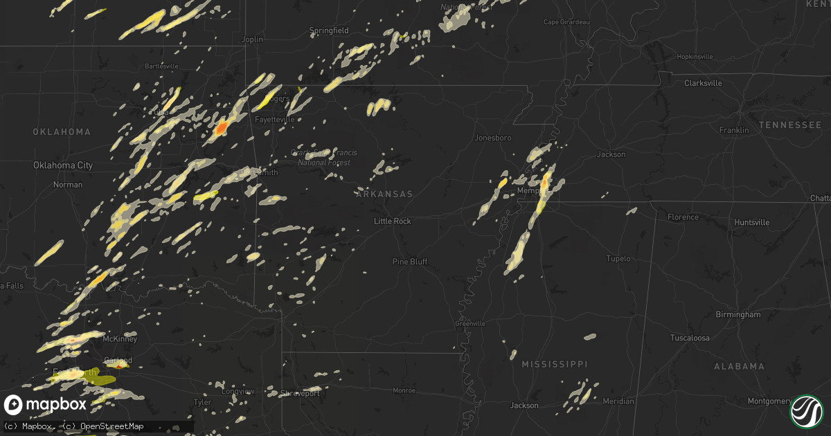
Hail Map in Arkansas on October 2, 2014
Get this storm
October 2 map
$229
one time, instant access
Download today. No call, no setup
Keep the $229
Bought the map and want the full workflow? Apply the entire $229 to a subscription within 7 days. None of it is wasted.
Every map, not just this one
This buys you this map. Subscription and you get every map we run, in the markets you choose from a few cities to whole states to nationwide. Plus real-time alerts the moment a storm fires.
Contact data
Name, contact info, occupancy, even credit band for addresses in the footprint. You go from where it hit to who to call.
Become the source they trust
Unlimited branding weather history reports on demand. You already have the documented answer ready for the property owner, and you are the one who showed up with it.
Property data and RoofTrace estimates
Pull up any address you have got, its value and the exact code rules for that jurisdiction, straight from One Click Code. Then RoofTrace estimates the squares, pitch, and roof value, priced the way you price.
Storm reports in Arkansas
Arkansas
| Date | Description |
|---|---|
| 10/02/20146:56 PM CDT | Trees reported down across us 270. |
| 10/02/20146:55 PM CDT | Numerous tree limbs were blown down. |
| 10/02/20146:50 PM CDT | Multiple power lines down...one resulting in a resulting in a residental structure fire. |
| 10/02/20146:45 PM CDT | Trees and power lines were blown down. |
| 10/02/20146:40 PM CDT | Trees across the road |
| 10/02/20146:35 PM CDT | A large tree was blown down. |
| 10/02/20146:35 PM CDT | Trees and power lines down. |
| 10/02/20146:32 PM CDT | A few trees down |
| 10/02/20146:32 PM CDT | A few trees down |
| 10/02/20146:30 PM CDT | Tree reported down across the county. |
| 10/02/20146:30 PM CDT | Large oak tree down at the corner of oak and south street in jasper. |
| 10/02/20146:27 PM CDT | Tree reported down across hwy 27 north of danville. |
| 10/02/20146:04 PM CDT | Trees down in grannis. |
| 10/02/20146:00 PM CDT | A local report indicates 65 MPH wind near DE QUEEN |
| 10/02/20145:59 PM CDT | Tree reported down across woodland rd. |
| 10/02/20145:50 PM CDT | Numerous trees down in hatfield. |
| 10/02/20145:45 PM CDT | Trees down on highway 71 south of potter. |
| 10/02/20145:35 PM CDT | Trees reported down in paris. |
| 10/02/20145:30 PM CDT | Power line and tree down on a house |
| 10/02/20145:29 PM CDT | Trees reported down across shaver rd. |
| 10/02/20145:29 PM CDT | Power line and tree down on a house |
| 10/02/20145:25 PM CDT | Trees down in the altus area... Hwy 64 is blocked. Time estimated by radar. |
| 10/02/20145:24 PM CDT | A local report indicates 60 MPH wind near 6 W OZARK |
| 10/02/20145:10 PM CDT | Large limbs were blown down. |
| 10/02/20145:09 PM CDT | Tree limbs down in lavaca |
| 10/02/20145:00 PM CDT | A local report indicates 1.00 inch wind near FORT SMITH |
| 10/02/20144:58 PM CDT | Wood privacy fence blown over |
| 10/02/20144:57 PM CDT | One inch hail in earle. |
| 10/02/20144:44 PM CDT | Winds of 50 to 60 mph buffeting police officers car in earle. |
| 10/02/20144:44 PM CDT | Golf ball size hail. |
| 10/02/20144:43 PM CDT | Golf ball sized hail. |
| 10/02/20142:03 PM CDT | Pea to quarter size hail |
| 10/02/20141:56 PM CDT | Pea to quarter size hail |
| 10/01/201410:18 PM CDT | Power poles and trees down near us highway 63 and nestle road. |
| 10/01/201410:15 PM CDT | Semi truck full of chicken parts blown over on highway 18 and highway 69. |
| 10/01/201410:09 PM CDT | Possible tornado spotted south of lake city moving east northeast. |
| 10/01/201410:05 PM CDT | Several trees and power lines down. |
| 10/01/201410:03 PM CDT | Power poles and trees down near us highway 63 and nestle road. |
| 10/01/20149:57 PM CDT | Widespread trees uprooted and roof damage. Estimated wind gusts up to 70 mph. |
| 10/01/20149:50 PM CDT | A freds discount store and a law firm had roof damage and windows blown out. |
| 10/01/20149:46 PM CDT | Thunderstorm winds gusting to 58 mph in caldwell. |
| 10/01/20149:28 PM CDT | Tornado damaged rice field with a varying pathwith the maximum width estimate at about 100 ft. |
| 10/01/20149:25 PM CDT | Large limbs were blown down. |
| 10/01/20149:14 PM CDT | Trees were blown down. |
| 10/01/20149:10 PM CDT | Tree reported down along old warren road. |
| 10/01/20149:00 PM CDT | Trees were reported down near cornerview road and highway 130. |
| 10/01/20149:00 PM CDT | Strong winds blew over a semi truck carrying chicken parts near highway 18 and highway 69. |
| 10/01/20149:00 PM CDT | Numerous trees down in the city with two homes damaged as well. |
| 10/01/20148:55 PM CDT | Trees were blown down...and there was damage to some houses. |
| 10/01/20148:55 PM CDT | This is at the stuttgart municipal airport. |
| 10/01/20148:45 PM CDT | Off elton parker road...a farm shop was destroyed...and there was damage to fences and a horse barn. |
| 10/01/20148:36 PM CDT | Large limbs were blown down. |
| 10/01/20148:35 PM CDT | A tree fell on a house causing an injury. |
| 10/01/20148:30 PM CDT | Trees down on central high road and highway 165. |
| 10/01/20148:30 PM CDT | Trees and powerlines down. |
| 10/01/20148:24 PM CDT | A local report indicates 60 MPH wind near 6 E WOODSON |
| 10/01/20148:24 PM CDT | Trees down on highway 161. |
| 10/01/20148:21 PM CDT | Trees down on interstate 530...blocking the southbound lanes. |
| 10/01/20148:20 PM CDT | A tree was blown down on highway 167. |
| 10/01/20148:18 PM CDT | Large highway sign down on interstate 440 near interstate 530. |
| 10/01/20148:15 PM CDT | Tree limbs down in cabot. |
| 10/01/20148:15 PM CDT | Tree fell on a vehicle...with occupant trapped on highway 365. |
| 10/01/20148:15 PM CDT | A tree was blown down on highway 167. |
| 10/01/20148:11 PM CDT | Tree completely blocking highway 9 four miles north of eagle mills. |
| 10/01/20148:10 PM CDT | Extensive tree damage at intersection of highway 5 and hilldale. |
| 10/01/20148:05 PM CDT | Multiple trees down throughout the county. |
| 10/01/20148:00 PM CDT | Trees were blown down near highway 7 and 207. |
| 10/01/20148:00 PM CDT | Power line down on interstate 30 between benton and bryant. |
| 10/01/20148:00 PM CDT | Trees and tree limbs were blown down...and there was some minor damage throughout the county. |
| 10/01/20148:00 PM CDT | The sheridan raws site reported a wind gust of 76 mph. |
| 10/01/20147:59 PM CDT | Tree down on springhill road and meadowbrook. |
| 10/01/20147:55 PM CDT | Tree fell on a truck with no injuries. |
| 10/01/20147:55 PM CDT | Numerous tree limbs were blown down. |
| 10/01/20147:50 PM CDT | Trees down in mountain view. |
| 10/01/20147:50 PM CDT | Two power poles were snapped. |
| 10/01/20147:44 PM CDT | Trees are down on highway 24 and highway 57. |
| 10/01/20147:40 PM CDT | There is a tree on a house with occupants inside in the overton area of malvern. |
| 10/01/20147:39 PM CDT | Signs were blown down onto i-40 near mayflower. |
| 10/01/20147:35 PM CDT | Trees down all over little river... On ark 41... 108... 32 and on cr 29... 11... And 15 |
| 10/01/20147:35 PM CDT | Tree down on highway 5 in owensville. |
| 10/01/20147:34 PM CDT | A tree fell on a house in gurdon. Numerous trees reported down across the county including on hwys 51...53... And 67. |
| 10/01/20147:33 PM CDT | A tree was blown down across hwy 9 and caused an accident. No injuries were reported. |
| 10/01/20147:30 PM CDT | Numerous trees down |
| 10/01/20147:27 PM CDT | Trees were blown down on interstate 30...and several cars crashed into them. |
| 10/01/20147:25 PM CDT | A tree was blown down on interstate 30 southwest of social hill. |
| 10/01/20147:23 PM CDT | Trees reported down on us 270 near the garland county fair grounds. |
| 10/01/20147:18 PM CDT | Tree limbs were blown down. |
| 10/01/20147:15 PM CDT | Tree limbs were blown down. |
| 10/01/20147:15 PM CDT | Two barns are damaged on creek trail. |
| 10/01/20147:15 PM CDT | Trees down hwys 67... 355... And 195 in hempstead county and in hope ar |
| 10/01/20147:10 PM CDT | Trees down...power lines down near intersection 10 and 17 |
| 10/01/20147:10 PM CDT | Trees and tree limbs down across the county. |
| 10/01/20147:09 PM CDT | A local report indicates 61 MPH wind near 3 NNE MOUNTAIN HOME |
| 10/01/20147:07 PM CDT | Trees were blown down. |
| 10/01/20147:05 PM CDT | Limbs were blown down. |
| 10/01/20147:02 PM CDT | Limbs were blown down. |
| 10/01/20147:02 PM CDT | Power lines down on highway 70. |
| 10/01/20147:00 PM CDT | Power lines down on highway 70. |
| 10/01/20147:00 PM CDT | Large tree limbs and branches down hwy 71 cr 10 |
| 10/01/20147:00 PM CDT | Trees were blown down near amity. |
All States Impacted by Hail Map on October 2, 2014
Cities Impacted by Hail Map on October 2, 2014
- Pryor, OK
- Adair, OK
- Porter, OK
- Earle, AR
- Ackerman, MS
- McCool, MS
- Weir, MS
- Louisville, MS
- Forrest City, AR
- Palestine, AR
- Haynes, AR
- Marianna, AR
- Mounds, OK
- Glenpool, OK
- Eureka Springs, AR
- Mountain Home, AR
- Clayton, OK
- Decatur, TX
- Okemah, OK
- Okmulgee, OK
- Clarksville, AR
- Gentry, AR
- Thornfield, MO
- Lipan, TX
- Parkin, AR
- Lampasas, TX
- Aledo, TX
- Fort Worth, TX
- Arlington, TX
- Naval Air Station Jrb, TX
- Jay, OK
- Colcord, OK
- Owasso, OK
- Tulsa, OK
- Claremore, OK
- Collinsville, OK
- Oologah, OK
- Cordova, TN
- Olive Branch, MS
- Nesbit, MS
- Millington, TN
- Memphis, TN
- Southaven, MS
- Arlington, TN
- Hernando, MS
- Rock, KS
- Winfield, KS
- Concordia, KS
- Sumner, IL
- Robinson, IL
- Oblong, IL
- Dyer, AR
- Alma, AR
- Mulberry, AR
- Seminole, OK
- Wewoka, OK
- Rhome, TX
- Oldfield, MO
- Seymour, MO
- Chadwick, MO
- Garrison, MO
- Ava, MO
- Clearwater, KS
- Haysville, KS
- Wichita, KS
- Mcconnell Afb, KS
- Welling, OK
- Kansas, OK
- Proctor, OK
- Hulbert, OK
- Muskogee, OK
- Park Hill, OK
- Tahlequah, OK
- Watts, OK
- Westville, OK
- Fort Gibson, OK
- Maysville, AR
- Wesley, AR
- Huntsville, AR
- Cedar Vale, KS
- Elk City, KS
- Sedan, KS
- Elk Falls, KS
- Moline, KS
- Fredonia, KS
- Longton, KS
- Ponder, TX
- Justin, TX
- Blue Rapids, KS
- Vermillion, KS
- Frankfort, KS
- Clyde, KS
- Palmer, KS
- Clifton, KS
- Linn, KS
- Montrose, MO
- Deepwater, MO
- Clinton, MO
- De Soto, MO
- Elkins, AR
- Nashoba, OK
- Lewisville, AR
- Rockwall, TX
- Rowlett, TX
- Mesquite, TX
- Garland, TX
- Dallas, TX
- Sunnyvale, TX
- Waxahachie, TX
- Fairview, KS
- Baileyville, KS
- Goff, KS
- Seneca, KS
- Sabetha, KS
- Corning, KS
- Centralia, KS
- Broken Arrow, OK
- Decatur, MS
- Mineral Point, MO
- Bonne Terre, MO
- Pinckneyville, IL
- Tamaroa, IL
- Clifton, TX
- Sanger, TX
- Valley View, TX
- Alvord, TX
- Era, TX
- Gainesville, TX
- Rosston, TX
- Thackerville, OK
- Ardmore, OK
- Lena, MS
- Lockhart, TX
- Dexter, KS
- Girard, KS
- Belton, TX
- Kellyville, OK
- Bristow, OK
- Sheldon, IL
- Belleview, MO
- Ironton, MO
- Middle Brook, MO
- Allen, OK
- Fitzhugh, OK
- Ada, OK
- Stonewall, OK
- Fittstown, OK
- Mcalester, OK
- Marlin, TX
- Coweta, OK
- Paris, AR
- Hope, AR
- Madill, OK
- Eddy, TX
- Bruceville, TX
- Theodosia, MO
- Rueter, MO
- Millstadt, IL
- Marshall, TX
- Waskom, TX
- Mountain Grove, MO
- Amity, AR
- Kingston, OK
- Marietta, OK
- Lebanon, OK
- Thornton, TX
- Franklin, TX
- Marquez, TX
- Jewett, TX
- Kosse, TX
- Centerville, TX
- Vance, MS
- El Dorado, KS
- Elk Creek, MO
- Willow Springs, MO
- Yukon, MO
- Delaware, AR
- Malvern, AR
- Reagan, TX
- Salem, MO
- Forest, MS
- Kentland, IN
- Bradleyville, MO
- Keota, OK
- Spiro, OK
- Aquilla, TX
- Whitney, TX
- Valley Mills, TX
- Smithton, MO
- Sedalia, MO
- Mora, MO
- Sullivan, MO
- Bourbon, MO
- Freeburg, MO
- Donie, TX
- Groesbeck, TX
- Lesterville, MO
- Annapolis, MO
- Wynona, OK
- Barnsdall, OK
- Hominy, OK
- Catoosa, OK
- Henderson, TX
- Mill Creek, OK
- Tishomingo, OK
- Overton, TX
- Coleman, OK
- Atoka, OK
- Conway Springs, KS
- Roanoke, TX
- Dale, TX
- Holdenville, OK
- Minden, LA
- Cotton Valley, LA
- Garwood, TX
- Powell, MO
- Pineville, MO
- Sallisaw, OK
- Muldrow, OK
- Roland, OK
- Stuart, OK
- Calvin, OK
- Aurora, KS
- Greenleaf, KS
- Fulton, AR
- Washington, AR
- Delight, AR
- Denton, TX
- Gerald, MO
- Success, MO
- Poteet, TX
- Granbury, TX
- Weatherford, TX
- Galesburg, KS
- Thayer, KS
- Independence, KS
- Cherryvale, KS
- Union, MS
- Conehatta, MS
- Lawrence, MS
- Kopperl, TX
- Story, AR
- Sims, AR
- Stroud, OK
- Haskell, OK
- Bixby, OK
- Carthage, AR
- West Plains, MO
- Pomona, MO
- Pacific, MO
- Eureka, MO
- Edgar Springs, MO
- Licking, MO
- Muenster, TX
- Flippin, AR
- Yellville, AR
- Eminence, MO
- Indianola, OK
- Hanna, OK
- Eufaula, OK
- Cameron, OK
- Quenemo, KS
- Pomona, KS
- Ottawa, KS
- Ridgedale, MO
- Protem, MO
- Oak Grove, AR
- Wasola, MO
- Kirbyville, MO
- Kissee Mills, MO
- Omaha, AR
- Noble, MO
- Hollister, MO
- Green Forest, AR
- Cedarcreek, MO
- Bremond, TX
- Sasakwa, OK
- McLean, IL
- Atlanta, IL
- Wolfe City, TX
- Little Rock, MS
- Kinta, OK
- Quinton, OK
- Plato, MO
- Sand Springs, OK
- Broken Bow, OK
- Peggs, OK
- Locust Grove, OK
- Galena, MO
- Crane, MO
- Yale, OK
- Weleetka, OK
- Crenshaw, MS
- Sarah, MS
- Dundee, MS
- Forestburg, TX
- Haslet, TX
- Norman, AR
- Arthur City, TX
- Noel, MO
- Mccurtain, OK
- Watson, OK
- Wickes, AR
- Grannis, AR
- Dustin, OK
- Waco, TX
- Riesel, TX
- Hewitt, TX
- Woodway, TX
- Waterville, KS
- Longview, TX
- Neodesha, KS
- Altoona, KS
- Baldwin City, KS
- Lawrence, KS
- Saint Paul, KS
- Ennis, TX
- Hartville, MO
- Vinita, OK
- Checotah, OK
- Tuskahoma, OK
- Antlers, OK
- Marks, MS
- Sledge, MS
- Lambert, MS
- Lane, OK
- Hallsville, TX
- Garfield, AR
- Bentonville, AR
- Centerton, AR
- Rogers, AR
- Seligman, MO
- Siloam Springs, AR
- Pea Ridge, AR
- Liberty, KS
- Thrall, TX
- Warner, OK
- Cresson, TX
- Lorena, TX
- Chilton, TX
- Loco, OK
- Duncan, OK
- Waurika, OK
- Vanzant, MO
- Red Oak, TX
- Park Hills, MO
- Bismarck, MO
- Piedmont, MO
- Norwood, MO
- Bunch, OK
- Wortham, TX
- Streetman, TX
- Roff, OK
- Wagoner, OK
- Crawfordsville, AR
- Smithville, OK
- Haughton, LA
- Dover, AR
- Andover, KS
- Red Rock, TX
- Crawford, TX
- Jonesboro, TX
- Oglesby, TX
- Gatesville, TX
- McGregor, TX
- Mart, TX
- Moody, TX
- Eureka, KS
- Barnes, KS
- Nowata, OK
- Chestnutridge, MO
- Walnut Shade, MO
- Ozark, MO
- Forsyth, MO
- Dierks, AR
- Meridian, TX
- Wilson, AR
- Bunker, MO
- Centerville, MO
- Ellington, MO
- Sparta, MO
- Linn, MO
- Springtown, TX
- Paradise, TX
- Coalgate, OK
- Hodgen, OK
- Cuba, MO
- Madison, KS
- Hamilton, KS
- Henning, TN
- Ripley, TN
- Howe, TX
- Sherman, TX
- Azle, TX
- Oakwood, TX
- Fairfield, TX
- Marshall, IL
- West Union, IL
- Benton, KS
- Bismarck, AR
- Tutwiler, MS
- Willow City, TX
- Fredericksburg, TX
- Asher, OK
- Newark, TX
- Keller, TX
- Athens, LA
- Homer, LA
- Hillsboro, TX
- Morgan, TX
- Parsons, KS
- Ringling, OK
- Ratliff City, OK
- Tussy, OK
- Hennepin, OK
- Comanche, OK
- Hubbard, TX
- Krebs, OK
- Flower Mound, TX
- Floresville, TX
- San Antonio, TX
- Adkins, TX
- Aubrey, TX
- Lake, MS
- La Vernia, TX
- Saint Louis, MO
- Fenton, MO
- Prosper, TX
- Krum, TX
- Celina, TX
- Gillham, AR
- Palestine, TX
- Purdon, TX
- Dawson, TX
- Pawnee, IL
- Farmersville, IL
- Harvel, IL
- Morrisonville, IL
- Hagarville, AR
- Ozone, AR
- Hartman, AR
- Oark, AR
- Cranfills Gap, TX
- Gassville, AR
- Cotter, AR
- Norfork, AR
- Hindsville, AR
- Springdale, AR
- Fayetteville, AR
- West Fork, AR
- Abbott, TX
- Depew, OK
- Wetumka, OK
- Heth, AR
- Sibley, LA
- Doyline, LA
- Tyler, TX
- Laneville, TX
- Summersville, MO
- Red Oak, OK
- Wilburton, OK
- Cabool, MO
- Osceola, AR
- High Ridge, MO
- House Springs, MO
- Catawissa, MO
- Robertsville, MO
- Coolidge, TX
- Poteau, OK
- Skiatook, OK
- Saint Clair, MO
- Yazoo City, MS
- Tchula, MS
- Hawk Point, MO
- Saint James, MO
- Mckinney, TX
- Blue Ridge, TX
- Jacksonville, TX
- Powderly, TX
- Ashdown, AR
- Waynesboro, MS
- West, TX
- Westphalia, MO
- Honobia, OK
- Hugo, OK
- Dennis, KS
- Welch, OK
- Llano, TX
- Melissa, TX
- Princeton, TX
- Wardville, OK
- Hot Springs Village, AR
- Palmer, TX
- Ferris, TX
- Middleton, TN
- Lonsdale, AR
- Cole Camp, MO
- Ionia, MO
- Lincoln, MO
- Marysville, KS
- Morrill, KS
- Morganville, KS
- Home, KS
- Hiawatha, KS
- Oneida, KS
- Coffeyville, KS
- Compton, AR
- Jasper, AR
- Ponca, AR
- Terre Haute, IN
- Udall, KS
- Berryville, AR
- West York, IL
- Martinsville, IL
- Burneyville, OK
- Du Quoin, IL
- Beggs, OK
- Corinth, MS
- Glen, MS
- Rienzi, MS
- Detroit, TX
- Cedar Creek, TX
- Hamilton, TX
- Evant, TX
- Cushing, OK
- Mannford, OK
- Drumright, OK
- Drummonds, TN
- Durant, OK
- Bokchito, OK
- Spavinaw, OK
- Tatum, TX
- Potosi, MO
- Steelville, MO
- Richards, MO
- Fort Scott, KS
- Huntington, AR
- Greenwood, AR
- Millsap, TX
- Rusk, TX
- Lockesburg, AR
- Milburn, OK
- Washburn, MO
- Decatur, AR
- Rocky Comfort, MO
- Bella Vista, AR
- Gravette, AR
- Sulphur Springs, AR
- Blevins, AR
- Prescott, AR
- Hawkins, TX
- Big Sandy, TX
- Manor, TX
- Shreveport, LA
- Axtell, KS
- Webbers Falls, OK
- Tupelo, OK
- Thayer, MO
- Morton, MS
- Pulaski, MS
- Kemp, TX
- Bee Branch, AR
- Damascus, AR
- Quitman, AR
- Clinton, AR
- Shirley, AR
- Coldwater, MS
- Atoka, TN
- Collierville, TN
- Brighton, TN
- Germantown, TN
- Eads, TN
- Marion, AR
- Senatobia, MS
- Oakland, TN
- Stratford, OK
- Moro, AR
- Widener, AR
- Madison, AR
- Anna, TX
- Van Alstyne, TX
- Argyle, TX
- Nevada, MO
- Redfield, KS
- Erie, KS
- Uniontown, KS
- Walnut, KS
- Havana, KS
- Hepler, KS
- Ozark, AR
- Kansas City, MO
- Del Valle, TX
- Austin, TX
- Bixby, MO
- Byars, OK
- Axtell, TX
- Mount Calm, TX
- Vassar, KS
- Overbrook, KS
- Waterloo, IL
- Murfreesboro, AR
- Boss, MO
- Drury, MO
- Haltom City, TX
- Frohna, MO
- Cedar Hill, MO
- Chandler, OK
- Aubrey, AR
- Gilmer, TX
- Gladewater, TX
- Owensville, MO
- Squires, MO
- Plattsburg, MO
- Valmeyer, IL
- Inola, OK
- Porum, OK
- Gore, OK
- Climax Springs, MO
- Russellville, AR
- Atwood, OK
- Whitesboro, TX
- Burns, KS
- Atlanta, KS
- Canehill, AR
- Evansville, AR
- Stilwell, OK
- Gans, OK
- Arkoma, OK
- Pocola, OK
- Van Buren, AR
- Fort Smith, AR
- Stigler, OK
- Walnut Springs, TX
- Glen Rose, TX
- Cape Fair, MO
- Aurora, MO
- Centrahoma, OK
- Pitkin, LA
- Fort Polk, LA
- Rich Hill, MO
- Rockville, MO
- Butler, MO
- Midlothian, TX
- Rockdale, TX
- Seguin, TX
- Fredericktown, MO
- Farmington, MO
- McCaskill, AR
- Wynnewood, OK
- Pauls Valley, OK
- Kenefic, OK
- Saint Jo, TX
- Lindsay, TX
- Eudora, AR
- Luling, TX
- Republic, MO
- Proctor, AR
- Pencil Bluff, AR
- Mount Ida, AR
- Frost, TX
- Kimberling City, MO
- Reeds Spring, MO
- Leasburg, MO
- Horatio, AR
- Osawatomie, KS
- Hatfield, AR
- Lonedell, MO
- Villa Ridge, MO
- Union, MO
- Saltillo, TX
- Winnsboro, TX
- Terrell, TX
- Anderson, MO
- Lamar, OK
- Honey Grove, TX
- Leesville, LA
- Mena, AR
- Caddo, OK
- Tennessee Colony, TX
- Talihina, OK
- Forreston, TX
- Itasca, TX
- Grandview, TX
- Italy, TX
- Milford, TX
- Winona, MO
- Stringtown, OK
- Wapanucka, OK
- Athens, TX
- Rolla, MO
- Cherryville, MO
- Bossier City, LA
- Barksdale Afb, LA
- Marshfield, MO
- Niangua, MO
- Conway, MO
- Ozan, AR
- Columbus, AR
- Saratoga, AR
- Trenton, TX
- Whitewright, TX
- Bonham, TX
- Randolph, TX
- Harrison, AR
- Penelope, TX
- Maud, OK
- Jenks, OK
- Chouteau, OK
- Boley, OK
- Sapulpa, OK
- Kiefer, OK
- Castle, OK
- Mount Olive, MS
- Bastrop, TX
- Mansfield, AR
- Booneville, AR
- Viola, KS
- Tillatoba, MS
- Oakland, MS
- Belzoni, MS
- Patton, MO
- Perryville, MO
- Langley, AR
- Glenwood, AR
- Kilgore, TX
- Flint, TX
- Chandler, TX
- Frankston, TX
- Mountain View, MO
- Appleton City, MO
- Schell City, MO
- Billings, MO
- Montalba, TX
- Turrell, AR
- Chanute, KS
- Munford, TN
- Grand Prairie, TX
- Paris, TX
- Blossom, TX
- McCune, KS
- Pottsboro, TX
- Gordonville, TX
- Sadler, TX
- Palmyra, IL
- Buffalo, TX
- Girard, IL
- Vivian, LA
- Black, MO
- Nashville, AR
- Newton, MS
- Cook Sta, MO
- Salina, OK
- Rose, OK
- Konawa, OK
- Walnut Grove, MS
- Branson, MO
- Walker, MO
- Cleveland, OK
- Jennings, OK
- Hico, TX
- Whitefield, OK
- Sulphur, OK
- Pine Hill, AL
- Lower Peach Tree, AL
- Taylor, TX
- Thorndale, TX
- Granger, TX
- Waldron, AR
- Rose Hill, KS
- Ochelata, OK
- Daisy, OK
- Redford, MO
- Moyers, OK
- Anacoco, LA
- Paris, IL
- Smithton, IL
- Hartford, AR
- Rattan, OK
- Snow, OK
- Augusta, KS
- Towanda, KS
- Lenapah, OK
- Wister, OK
- Cove, AR
- Savanna, OK
- Devine, TX
- Natalia, TX
- Hackett, AR
- Oswego, KS
- Caddo Gap, AR
- Troup, TX
- Kingston, AR
- Finley, OK
- Lepanto, AR
- Marked Tree, AR
- Springfield, AR
- Dana, IN
- Chrisman, IL
- S Coffeyville, OK
- Santo, TX
- Farmersville, TX
- Joiner, AR
- Effingham, IL
- Sulphur Springs, TX
- Nemo, TX
- Doe Run, MO
- Arcadia, MO
- Caledonia, MO
- Bland, MO
- Eagle Rock, MO
- Cassville, MO
- Burleson, TX
- Godley, TX
- Mansfield, TX
- Joshua, TX
- Kennedale, TX
- Crowley, TX
- Bonnerdale, AR
- Wellington, KS
- Oden, AR
- Eudora, KS
- Elmendorf, TX
- Davis, OK
- Sumner, TX
- Bennington, OK
- Louisville, IL
- Newton, IL
- Dieterich, IL
- Sibley, IL
- Henryetta, OK
- Okolona, AR
- Charleston, MS
- Texarkana, AR
- Fouke, AR
- Burnet, TX
- Fayetteville, TX
- New Ulm, TX
- Columbia, IL
- Scurry, TX
- Rosser, TX
- Arcadia, KS
- Prague, OK
- Sparks, OK
- Taneyville, MO
- Cedar Hill, TX
- Venus, TX
- Alvarado, TX
- Maypearl, TX
- Edgerton, KS
- Little Elm, TX
- Boyd, TX
- Poolville, TX
- Bridgeport, TX
- Stamps, AR
- Mount Vernon, TX
- Sperry, OK
- Mead, OK
- London, AR
- Belleville, IL
- Greenwood, LA
- Mountain Pine, AR
- Hot Springs National Park, AR
- Stephenville, TX
- Morrilton, AR
- Pilot Point, TX
- Lamar, AR
- Reklaw, TX
- Stewartsville, MO
- Center Ridge, AR
- Mountainburg, AR
- Adona, AR
- Lyon, MS
- Clarksdale, MS
- Nashville, IL
- Olathe, KS
- Gardner, KS
- De Soto, KS
- Talala, OK
- Plumerville, AR
- Moore, TX
- Vian, OK
- Wynne, AR
- Willow Hill, IL
- Whitehouse, TX
- Kirby, AR
- Dewey, OK
- Bartlesville, OK
- Filley, NE
- Auburn, NE
- Adams, NE
- Tecumseh, NE
- Elk Creek, NE
- Johnson, NE
- Beatrice, NE
- Pickrell, NE
- Sterling, NE
- Crab Orchard, NE
- Waldo, KS
- Hunter, KS
- Beloit, KS
- Simpson, KS
- Luray, KS
- Lucas, KS
- Jamestown, KS
- Glen Elder, KS
- Glasco, KS
- Tipton, KS
- Osborne, KS
- Forney, TX
- Desoto, TX
- Irving, TX
- Duncanville, TX
- Wilmer, TX
- Lancaster, TX
- Hutchins, TX


