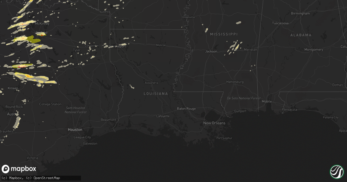
Hail Map in Louisiana on October 2, 2014
Get this storm
October 2 map
$229
one time, instant access
Download today. No call, no setup
Keep the $229
Bought the map and want the full workflow? Apply the entire $229 to a subscription within 7 days. None of it is wasted.
Every map, not just this one
This buys you this map. Subscription and you get every map we run, in the markets you choose from a few cities to whole states to nationwide. Plus real-time alerts the moment a storm fires.
Contact data
Name, contact info, occupancy, even credit band for addresses in the footprint. You go from where it hit to who to call.
Become the source they trust
Unlimited branding weather history reports on demand. You already have the documented answer ready for the property owner, and you are the one who showed up with it.
Property data and RoofTrace estimates
Pull up any address you have got, its value and the exact code rules for that jurisdiction, straight from One Click Code. Then RoofTrace estimates the squares, pitch, and roof value, priced the way you price.
Storm reports in Louisiana
Louisiana
| Date | Description |
|---|---|
| 10/02/20146:42 PM CDT | A tree fell on top of a mobile home on stewart road in haughton. |
| 10/02/20146:42 PM CDT | Power lines down...numerous trees down |
| 10/02/20146:25 PM CDT | Numerous trees down...power lines down |
| 10/01/20149:45 PM CDT | Tree and power line down |
| 10/01/20149:45 PM CDT | Trees and poweline down in the area |
| 10/01/20149:14 PM CDT | Tree fell on vehicle in shreve city neighborhood |
| 10/01/20148:40 PM CDT | A tree fell on the corner unit of the woodlawn terrace apartments on west 68th street. |
| 10/01/20148:31 PM CDT | Tree down behind 50 vandenberg on barksdale afb |
| 10/01/20148:30 PM CDT | Numerous trees down...power lines down northern bossier parish |
| 10/01/20147:50 PM CDT | Power lines down on vivian airport road |
| 10/01/20147:27 PM CDT | Tree down |
All States Impacted by Hail Map on October 2, 2014
Cities Impacted by Hail Map on October 2, 2014
- Pryor, OK
- Adair, OK
- Porter, OK
- Earle, AR
- Ackerman, MS
- McCool, MS
- Weir, MS
- Louisville, MS
- Forrest City, AR
- Palestine, AR
- Haynes, AR
- Marianna, AR
- Mounds, OK
- Glenpool, OK
- Eureka Springs, AR
- Mountain Home, AR
- Clayton, OK
- Decatur, TX
- Okemah, OK
- Okmulgee, OK
- Clarksville, AR
- Gentry, AR
- Thornfield, MO
- Lipan, TX
- Parkin, AR
- Lampasas, TX
- Aledo, TX
- Fort Worth, TX
- Arlington, TX
- Naval Air Station Jrb, TX
- Jay, OK
- Colcord, OK
- Owasso, OK
- Tulsa, OK
- Claremore, OK
- Collinsville, OK
- Oologah, OK
- Cordova, TN
- Olive Branch, MS
- Nesbit, MS
- Millington, TN
- Memphis, TN
- Southaven, MS
- Arlington, TN
- Hernando, MS
- Rock, KS
- Winfield, KS
- Concordia, KS
- Sumner, IL
- Robinson, IL
- Oblong, IL
- Dyer, AR
- Alma, AR
- Mulberry, AR
- Seminole, OK
- Wewoka, OK
- Rhome, TX
- Oldfield, MO
- Seymour, MO
- Chadwick, MO
- Garrison, MO
- Ava, MO
- Clearwater, KS
- Haysville, KS
- Wichita, KS
- Mcconnell Afb, KS
- Welling, OK
- Kansas, OK
- Proctor, OK
- Hulbert, OK
- Muskogee, OK
- Park Hill, OK
- Tahlequah, OK
- Watts, OK
- Westville, OK
- Fort Gibson, OK
- Maysville, AR
- Wesley, AR
- Huntsville, AR
- Cedar Vale, KS
- Elk City, KS
- Sedan, KS
- Elk Falls, KS
- Moline, KS
- Fredonia, KS
- Longton, KS
- Ponder, TX
- Justin, TX
- Blue Rapids, KS
- Vermillion, KS
- Frankfort, KS
- Clyde, KS
- Palmer, KS
- Clifton, KS
- Linn, KS
- Montrose, MO
- Deepwater, MO
- Clinton, MO
- De Soto, MO
- Elkins, AR
- Nashoba, OK
- Lewisville, AR
- Rockwall, TX
- Rowlett, TX
- Mesquite, TX
- Garland, TX
- Dallas, TX
- Sunnyvale, TX
- Waxahachie, TX
- Fairview, KS
- Baileyville, KS
- Goff, KS
- Seneca, KS
- Sabetha, KS
- Corning, KS
- Centralia, KS
- Broken Arrow, OK
- Decatur, MS
- Mineral Point, MO
- Bonne Terre, MO
- Pinckneyville, IL
- Tamaroa, IL
- Clifton, TX
- Sanger, TX
- Valley View, TX
- Alvord, TX
- Era, TX
- Gainesville, TX
- Rosston, TX
- Thackerville, OK
- Ardmore, OK
- Lena, MS
- Lockhart, TX
- Dexter, KS
- Girard, KS
- Belton, TX
- Kellyville, OK
- Bristow, OK
- Sheldon, IL
- Belleview, MO
- Ironton, MO
- Middle Brook, MO
- Allen, OK
- Fitzhugh, OK
- Ada, OK
- Stonewall, OK
- Fittstown, OK
- Mcalester, OK
- Marlin, TX
- Coweta, OK
- Paris, AR
- Hope, AR
- Madill, OK
- Eddy, TX
- Bruceville, TX
- Theodosia, MO
- Rueter, MO
- Millstadt, IL
- Marshall, TX
- Waskom, TX
- Mountain Grove, MO
- Amity, AR
- Kingston, OK
- Marietta, OK
- Lebanon, OK
- Thornton, TX
- Franklin, TX
- Marquez, TX
- Jewett, TX
- Kosse, TX
- Centerville, TX
- Vance, MS
- El Dorado, KS
- Elk Creek, MO
- Willow Springs, MO
- Yukon, MO
- Delaware, AR
- Malvern, AR
- Reagan, TX
- Salem, MO
- Forest, MS
- Kentland, IN
- Bradleyville, MO
- Keota, OK
- Spiro, OK
- Aquilla, TX
- Whitney, TX
- Valley Mills, TX
- Smithton, MO
- Sedalia, MO
- Mora, MO
- Sullivan, MO
- Bourbon, MO
- Freeburg, MO
- Donie, TX
- Groesbeck, TX
- Lesterville, MO
- Annapolis, MO
- Wynona, OK
- Barnsdall, OK
- Hominy, OK
- Catoosa, OK
- Henderson, TX
- Mill Creek, OK
- Tishomingo, OK
- Overton, TX
- Coleman, OK
- Atoka, OK
- Conway Springs, KS
- Roanoke, TX
- Dale, TX
- Holdenville, OK
- Minden, LA
- Cotton Valley, LA
- Garwood, TX
- Powell, MO
- Pineville, MO
- Sallisaw, OK
- Muldrow, OK
- Roland, OK
- Stuart, OK
- Calvin, OK
- Aurora, KS
- Greenleaf, KS
- Fulton, AR
- Washington, AR
- Delight, AR
- Denton, TX
- Gerald, MO
- Success, MO
- Poteet, TX
- Granbury, TX
- Weatherford, TX
- Galesburg, KS
- Thayer, KS
- Independence, KS
- Cherryvale, KS
- Union, MS
- Conehatta, MS
- Lawrence, MS
- Kopperl, TX
- Story, AR
- Sims, AR
- Stroud, OK
- Haskell, OK
- Bixby, OK
- Carthage, AR
- West Plains, MO
- Pomona, MO
- Pacific, MO
- Eureka, MO
- Edgar Springs, MO
- Licking, MO
- Muenster, TX
- Flippin, AR
- Yellville, AR
- Eminence, MO
- Indianola, OK
- Hanna, OK
- Eufaula, OK
- Cameron, OK
- Quenemo, KS
- Pomona, KS
- Ottawa, KS
- Ridgedale, MO
- Protem, MO
- Oak Grove, AR
- Wasola, MO
- Kirbyville, MO
- Kissee Mills, MO
- Omaha, AR
- Noble, MO
- Hollister, MO
- Green Forest, AR
- Cedarcreek, MO
- Bremond, TX
- Sasakwa, OK
- McLean, IL
- Atlanta, IL
- Wolfe City, TX
- Little Rock, MS
- Kinta, OK
- Quinton, OK
- Plato, MO
- Sand Springs, OK
- Broken Bow, OK
- Peggs, OK
- Locust Grove, OK
- Galena, MO
- Crane, MO
- Yale, OK
- Weleetka, OK
- Crenshaw, MS
- Sarah, MS
- Dundee, MS
- Forestburg, TX
- Haslet, TX
- Norman, AR
- Arthur City, TX
- Noel, MO
- Mccurtain, OK
- Watson, OK
- Wickes, AR
- Grannis, AR
- Dustin, OK
- Waco, TX
- Riesel, TX
- Hewitt, TX
- Woodway, TX
- Waterville, KS
- Longview, TX
- Neodesha, KS
- Altoona, KS
- Baldwin City, KS
- Lawrence, KS
- Saint Paul, KS
- Ennis, TX
- Hartville, MO
- Vinita, OK
- Checotah, OK
- Tuskahoma, OK
- Antlers, OK
- Marks, MS
- Sledge, MS
- Lambert, MS
- Lane, OK
- Hallsville, TX
- Garfield, AR
- Bentonville, AR
- Centerton, AR
- Rogers, AR
- Seligman, MO
- Siloam Springs, AR
- Pea Ridge, AR
- Liberty, KS
- Thrall, TX
- Warner, OK
- Cresson, TX
- Lorena, TX
- Chilton, TX
- Loco, OK
- Duncan, OK
- Waurika, OK
- Vanzant, MO
- Red Oak, TX
- Park Hills, MO
- Bismarck, MO
- Piedmont, MO
- Norwood, MO
- Bunch, OK
- Wortham, TX
- Streetman, TX
- Roff, OK
- Wagoner, OK
- Crawfordsville, AR
- Smithville, OK
- Haughton, LA
- Dover, AR
- Andover, KS
- Red Rock, TX
- Crawford, TX
- Jonesboro, TX
- Oglesby, TX
- Gatesville, TX
- McGregor, TX
- Mart, TX
- Moody, TX
- Eureka, KS
- Barnes, KS
- Nowata, OK
- Chestnutridge, MO
- Walnut Shade, MO
- Ozark, MO
- Forsyth, MO
- Dierks, AR
- Meridian, TX
- Wilson, AR
- Bunker, MO
- Centerville, MO
- Ellington, MO
- Sparta, MO
- Linn, MO
- Springtown, TX
- Paradise, TX
- Coalgate, OK
- Hodgen, OK
- Cuba, MO
- Madison, KS
- Hamilton, KS
- Henning, TN
- Ripley, TN
- Howe, TX
- Sherman, TX
- Azle, TX
- Oakwood, TX
- Fairfield, TX
- Marshall, IL
- West Union, IL
- Benton, KS
- Bismarck, AR
- Tutwiler, MS
- Willow City, TX
- Fredericksburg, TX
- Asher, OK
- Newark, TX
- Keller, TX
- Athens, LA
- Homer, LA
- Hillsboro, TX
- Morgan, TX
- Parsons, KS
- Ringling, OK
- Ratliff City, OK
- Tussy, OK
- Hennepin, OK
- Comanche, OK
- Hubbard, TX
- Krebs, OK
- Flower Mound, TX
- Floresville, TX
- San Antonio, TX
- Adkins, TX
- Aubrey, TX
- Lake, MS
- La Vernia, TX
- Saint Louis, MO
- Fenton, MO
- Prosper, TX
- Krum, TX
- Celina, TX
- Gillham, AR
- Palestine, TX
- Purdon, TX
- Dawson, TX
- Pawnee, IL
- Farmersville, IL
- Harvel, IL
- Morrisonville, IL
- Hagarville, AR
- Ozone, AR
- Hartman, AR
- Oark, AR
- Cranfills Gap, TX
- Gassville, AR
- Cotter, AR
- Norfork, AR
- Hindsville, AR
- Springdale, AR
- Fayetteville, AR
- West Fork, AR
- Abbott, TX
- Depew, OK
- Wetumka, OK
- Heth, AR
- Sibley, LA
- Doyline, LA
- Tyler, TX
- Laneville, TX
- Summersville, MO
- Red Oak, OK
- Wilburton, OK
- Cabool, MO
- Osceola, AR
- High Ridge, MO
- House Springs, MO
- Catawissa, MO
- Robertsville, MO
- Coolidge, TX
- Poteau, OK
- Skiatook, OK
- Saint Clair, MO
- Yazoo City, MS
- Tchula, MS
- Hawk Point, MO
- Saint James, MO
- Mckinney, TX
- Blue Ridge, TX
- Jacksonville, TX
- Powderly, TX
- Ashdown, AR
- Waynesboro, MS
- West, TX
- Westphalia, MO
- Honobia, OK
- Hugo, OK
- Dennis, KS
- Welch, OK
- Llano, TX
- Melissa, TX
- Princeton, TX
- Wardville, OK
- Hot Springs Village, AR
- Palmer, TX
- Ferris, TX
- Middleton, TN
- Lonsdale, AR
- Cole Camp, MO
- Ionia, MO
- Lincoln, MO
- Marysville, KS
- Morrill, KS
- Morganville, KS
- Home, KS
- Hiawatha, KS
- Oneida, KS
- Coffeyville, KS
- Compton, AR
- Jasper, AR
- Ponca, AR
- Terre Haute, IN
- Udall, KS
- Berryville, AR
- West York, IL
- Martinsville, IL
- Burneyville, OK
- Du Quoin, IL
- Beggs, OK
- Corinth, MS
- Glen, MS
- Rienzi, MS
- Detroit, TX
- Cedar Creek, TX
- Hamilton, TX
- Evant, TX
- Cushing, OK
- Mannford, OK
- Drumright, OK
- Drummonds, TN
- Durant, OK
- Bokchito, OK
- Spavinaw, OK
- Tatum, TX
- Potosi, MO
- Steelville, MO
- Richards, MO
- Fort Scott, KS
- Huntington, AR
- Greenwood, AR
- Millsap, TX
- Rusk, TX
- Lockesburg, AR
- Milburn, OK
- Washburn, MO
- Decatur, AR
- Rocky Comfort, MO
- Bella Vista, AR
- Gravette, AR
- Sulphur Springs, AR
- Blevins, AR
- Prescott, AR
- Hawkins, TX
- Big Sandy, TX
- Manor, TX
- Shreveport, LA
- Axtell, KS
- Webbers Falls, OK
- Tupelo, OK
- Thayer, MO
- Morton, MS
- Pulaski, MS
- Kemp, TX
- Bee Branch, AR
- Damascus, AR
- Quitman, AR
- Clinton, AR
- Shirley, AR
- Coldwater, MS
- Atoka, TN
- Collierville, TN
- Brighton, TN
- Germantown, TN
- Eads, TN
- Marion, AR
- Senatobia, MS
- Oakland, TN
- Stratford, OK
- Moro, AR
- Widener, AR
- Madison, AR
- Anna, TX
- Van Alstyne, TX
- Argyle, TX
- Nevada, MO
- Redfield, KS
- Erie, KS
- Uniontown, KS
- Walnut, KS
- Havana, KS
- Hepler, KS
- Ozark, AR
- Kansas City, MO
- Del Valle, TX
- Austin, TX
- Bixby, MO
- Byars, OK
- Axtell, TX
- Mount Calm, TX
- Vassar, KS
- Overbrook, KS
- Waterloo, IL
- Murfreesboro, AR
- Boss, MO
- Drury, MO
- Haltom City, TX
- Frohna, MO
- Cedar Hill, MO
- Chandler, OK
- Aubrey, AR
- Gilmer, TX
- Gladewater, TX
- Owensville, MO
- Squires, MO
- Plattsburg, MO
- Valmeyer, IL
- Inola, OK
- Porum, OK
- Gore, OK
- Climax Springs, MO
- Russellville, AR
- Atwood, OK
- Whitesboro, TX
- Burns, KS
- Atlanta, KS
- Canehill, AR
- Evansville, AR
- Stilwell, OK
- Gans, OK
- Arkoma, OK
- Pocola, OK
- Van Buren, AR
- Fort Smith, AR
- Stigler, OK
- Walnut Springs, TX
- Glen Rose, TX
- Cape Fair, MO
- Aurora, MO
- Centrahoma, OK
- Pitkin, LA
- Fort Polk, LA
- Rich Hill, MO
- Rockville, MO
- Butler, MO
- Midlothian, TX
- Rockdale, TX
- Seguin, TX
- Fredericktown, MO
- Farmington, MO
- McCaskill, AR
- Wynnewood, OK
- Pauls Valley, OK
- Kenefic, OK
- Saint Jo, TX
- Lindsay, TX
- Eudora, AR
- Luling, TX
- Republic, MO
- Proctor, AR
- Pencil Bluff, AR
- Mount Ida, AR
- Frost, TX
- Kimberling City, MO
- Reeds Spring, MO
- Leasburg, MO
- Horatio, AR
- Osawatomie, KS
- Hatfield, AR
- Lonedell, MO
- Villa Ridge, MO
- Union, MO
- Saltillo, TX
- Winnsboro, TX
- Terrell, TX
- Anderson, MO
- Lamar, OK
- Honey Grove, TX
- Leesville, LA
- Mena, AR
- Caddo, OK
- Tennessee Colony, TX
- Talihina, OK
- Forreston, TX
- Itasca, TX
- Grandview, TX
- Italy, TX
- Milford, TX
- Winona, MO
- Stringtown, OK
- Wapanucka, OK
- Athens, TX
- Rolla, MO
- Cherryville, MO
- Bossier City, LA
- Barksdale Afb, LA
- Marshfield, MO
- Niangua, MO
- Conway, MO
- Ozan, AR
- Columbus, AR
- Saratoga, AR
- Trenton, TX
- Whitewright, TX
- Bonham, TX
- Randolph, TX
- Harrison, AR
- Penelope, TX
- Maud, OK
- Jenks, OK
- Chouteau, OK
- Boley, OK
- Sapulpa, OK
- Kiefer, OK
- Castle, OK
- Mount Olive, MS
- Bastrop, TX
- Mansfield, AR
- Booneville, AR
- Viola, KS
- Tillatoba, MS
- Oakland, MS
- Belzoni, MS
- Patton, MO
- Perryville, MO
- Langley, AR
- Glenwood, AR
- Kilgore, TX
- Flint, TX
- Chandler, TX
- Frankston, TX
- Mountain View, MO
- Appleton City, MO
- Schell City, MO
- Billings, MO
- Montalba, TX
- Turrell, AR
- Chanute, KS
- Munford, TN
- Grand Prairie, TX
- Paris, TX
- Blossom, TX
- McCune, KS
- Pottsboro, TX
- Gordonville, TX
- Sadler, TX
- Palmyra, IL
- Buffalo, TX
- Girard, IL
- Vivian, LA
- Black, MO
- Nashville, AR
- Newton, MS
- Cook Sta, MO
- Salina, OK
- Rose, OK
- Konawa, OK
- Walnut Grove, MS
- Branson, MO
- Walker, MO
- Cleveland, OK
- Jennings, OK
- Hico, TX
- Whitefield, OK
- Sulphur, OK
- Pine Hill, AL
- Lower Peach Tree, AL
- Taylor, TX
- Thorndale, TX
- Granger, TX
- Waldron, AR
- Rose Hill, KS
- Ochelata, OK
- Daisy, OK
- Redford, MO
- Moyers, OK
- Anacoco, LA
- Paris, IL
- Smithton, IL
- Hartford, AR
- Rattan, OK
- Snow, OK
- Augusta, KS
- Towanda, KS
- Lenapah, OK
- Wister, OK
- Cove, AR
- Savanna, OK
- Devine, TX
- Natalia, TX
- Hackett, AR
- Oswego, KS
- Caddo Gap, AR
- Troup, TX
- Kingston, AR
- Finley, OK
- Lepanto, AR
- Marked Tree, AR
- Springfield, AR
- Dana, IN
- Chrisman, IL
- S Coffeyville, OK
- Santo, TX
- Farmersville, TX
- Joiner, AR
- Effingham, IL
- Sulphur Springs, TX
- Nemo, TX
- Doe Run, MO
- Arcadia, MO
- Caledonia, MO
- Bland, MO
- Eagle Rock, MO
- Cassville, MO
- Burleson, TX
- Godley, TX
- Mansfield, TX
- Joshua, TX
- Kennedale, TX
- Crowley, TX
- Bonnerdale, AR
- Wellington, KS
- Oden, AR
- Eudora, KS
- Elmendorf, TX
- Davis, OK
- Sumner, TX
- Bennington, OK
- Louisville, IL
- Newton, IL
- Dieterich, IL
- Sibley, IL
- Henryetta, OK
- Okolona, AR
- Charleston, MS
- Texarkana, AR
- Fouke, AR
- Burnet, TX
- Fayetteville, TX
- New Ulm, TX
- Columbia, IL
- Scurry, TX
- Rosser, TX
- Arcadia, KS
- Prague, OK
- Sparks, OK
- Taneyville, MO
- Cedar Hill, TX
- Venus, TX
- Alvarado, TX
- Maypearl, TX
- Edgerton, KS
- Little Elm, TX
- Boyd, TX
- Poolville, TX
- Bridgeport, TX
- Stamps, AR
- Mount Vernon, TX
- Sperry, OK
- Mead, OK
- London, AR
- Belleville, IL
- Greenwood, LA
- Mountain Pine, AR
- Hot Springs National Park, AR
- Stephenville, TX
- Morrilton, AR
- Pilot Point, TX
- Lamar, AR
- Reklaw, TX
- Stewartsville, MO
- Center Ridge, AR
- Mountainburg, AR
- Adona, AR
- Lyon, MS
- Clarksdale, MS
- Nashville, IL
- Olathe, KS
- Gardner, KS
- De Soto, KS
- Talala, OK
- Plumerville, AR
- Moore, TX
- Vian, OK
- Wynne, AR
- Willow Hill, IL
- Whitehouse, TX
- Kirby, AR
- Dewey, OK
- Bartlesville, OK
- Filley, NE
- Auburn, NE
- Adams, NE
- Tecumseh, NE
- Elk Creek, NE
- Johnson, NE
- Beatrice, NE
- Pickrell, NE
- Sterling, NE
- Crab Orchard, NE
- Waldo, KS
- Hunter, KS
- Beloit, KS
- Simpson, KS
- Luray, KS
- Lucas, KS
- Jamestown, KS
- Glen Elder, KS
- Glasco, KS
- Tipton, KS
- Osborne, KS
- Forney, TX
- Desoto, TX
- Irving, TX
- Duncanville, TX
- Wilmer, TX
- Lancaster, TX
- Hutchins, TX


