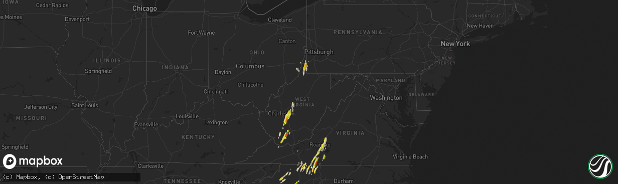
Hail Map in West Virginia on September 29, 2016
The weather event in West Virginia on September 29, 2016 includes Hail map. 11 states and 185 cities were impacted and suffered possible damage. The total estimated number of properties impacted is 8,112.
Want more than just the map?
Turn this storm into a full workflow.
- Owner + property data so you know who to knock
- OnDemand branded weather history reports to win the "did we even have hail?" argument
- RoofTrace estimate so reps stop guessing numbers at the door
Bought this map? Upgrade within 7 days and we'll credit the $230. (10-15 min setup call)
Hail
8,112
Estimated number of impacted properties by a 1.00" hail or larger1,068
Estimated number of impacted properties by a 1.75" hail or larger0
Estimated number of impacted properties by a 2.50" hail or largerStorm reports in West Virginia
West Virginia
| Date | Description |
|---|---|
| 09/29/20163:11 PM CDT | Quarter size hail along number2 ridge road in dallas... Wv |
| 09/29/20162:45 PM CDT | Trained spotter.... Took video with timestamp. |
| 09/29/20162:37 PM CDT | A local report indicates 1.00 inch wind near WARD |
| 09/29/20162:36 PM CDT | Trees down |
| 09/29/20162:35 PM CDT | Near i-70 and dallas pike |
| 09/29/20162:31 PM CDT | Trees down |
| 09/29/20162:31 PM CDT | Trees down |
| 09/29/20162:22 PM CDT | Hail reported to be larger than the size of a quarter |
| 09/29/20162:20 PM CDT | Many stones around nickel size and a few as large as silver dollars. |
| 09/29/20162:19 PM CDT | A local report indicates 1.00 inch wind near MULLENS |
| 09/29/20162:17 PM CDT | Trees down |
| 09/29/20162:16 PM CDT | Reported at the lodge. Time estimated by radar. |
| 09/29/20162:15 PM CDT | Hail up to golf ball size reported |
| 09/29/20162:14 PM CDT | A local report indicates 1.50 inch wind near LONE OAK |
| 09/29/20162:12 PM CDT | Per metro911 trees and powerlines down across paint creek rd |
| 09/29/20162:11 PM CDT | A lot of hail with many stones up to quarter size |
| 09/29/20161:57 PM CDT | A local report indicates 1.00 inch wind near 3 NNE WHITESVILLE |
| 09/29/20161:47 PM CDT | Doh mcdowell south of welch |
| 09/29/20161:47 PM CDT | Doh mcdowell south of welch |
| 09/29/20161:41 PM CDT | Trees down |
| 09/29/20161:34 PM CDT | Trees down |
| 09/29/20161:34 PM CDT | Trees down |
All States Impacted by Hail Map on September 29, 2016
Cities Impacted by Hail Map on September 29, 2016
- Cameron, WV
- New Martinsville, WV
- West Finley, PA
- Madison, NC
- Walnut Cove, NC
- Sandy Ridge, NC
- Max Meadows, VA
- Wind Ridge, PA
- Oracle, AZ
- Tucson, AZ
- Mammoth, WV
- Glen, WV
- Indore, WV
- London, WV
- Blount, WV
- Drybranch, WV
- Clendenin, WV
- Glasgow, WV
- East Bank, WV
- Miami, WV
- Orgas, WV
- Belle, WV
- Bomont, WV
- Smithers, WV
- Eskdale, WV
- Lizemores, WV
- Hansford, WV
- Pratt, WV
- Montgomery, WV
- Pond Gap, WV
- Cedar Grove, WV
- Gallagher, WV
- Mayodan, NC
- Whiteriver, AZ
- Benson, AZ
- New Smyrna Beach, FL
- Lenoir, NC
- Purlear, NC
- Millers Creek, NC
- McGrady, NC
- Bassett, VA
- Mims, FL
- Mount Airy, NC
- Vinton, VA
- Montvale, VA
- Thaxton, VA
- Blue Ridge, VA
- Critz, VA
- Patrick Springs, VA
- Olin, NC
- Harmony, NC
- Pineville, WV
- New Richmond, WV
- Saulsville, WV
- Lester, WV
- Slab Fork, WV
- Glen Daniel, WV
- Brenton, WV
- Clear Fork, WV
- Lawsonville, NC
- Stuart, VA
- Spencer, VA
- Itmann, WV
- Maben, WV
- Paynesville, WV
- Welch, WV
- Herndon, WV
- Cyclone, WV
- Oceana, WV
- Iaeger, WV
- Laurel Springs, NC
- Danbury, NC
- Germanton, NC
- Westfield, NC
- Clifton, AZ
- Blue, AZ
- Saint David, AZ
- Winterville, NC
- Naoma, WV
- Wharton, WV
- Johnsonville, SC
- Varnville, SC
- Islandton, SC
- Ruffin, SC
- Pearce, AZ
- Chloe, WV
- Hardy, VA
- Goodview, VA
- Boones Mill, VA
- Pooler, GA
- Savannah, GA
- Whitesville, WV
- Orlando, FL
- Bedford, VA
- Roanoke, VA
- Newton, WV
- Orma, WV
- Procious, WV
- Wallback, WV
- Thurmond, NC
- Dobson, NC
- Rocky Mount, VA
- Wirtz, VA
- Wheeling, WV
- Triadelphia, WV
- Moundsville, WV
- Glen Easton, WV
- Dallas, WV
- Ridgeland, SC
- Estill, SC
- Early Branch, SC
- Walterboro, SC
- Yemassee, SC
- Pineland, SC
- Bridgeport, OH
- Ferrum, VA
- Osteen, FL
- Cana, VA
- Fancy Gap, VA
- Lambsburg, VA
- Princewick, WV
- Rhodell, WV
- Midway, WV
- Sophia, WV
- Willcox, AZ
- Martinsville, VA
- Bandy, VA
- Jewell Ridge, VA
- Pilot Mountain, NC
- Pinnacle, NC
- Beallsville, OH
- Jacobsburg, OH
- Alledonia, OH
- Proctor, WV
- Clarington, OH
- Powhatan Point, OH
- Callaway, VA
- Penhook, VA
- Claysville, PA
- Edgewater, FL
- Galax, VA
- Fairdale, WV
- Moneta, VA
- Collettsville, NC
- Cubero, NM
- Mount Lemmon, AZ
- Henry, VA
- Tobaccoville, NC
- King, NC
- Buchanan, VA
- Lowgap, NC
- Ararat, VA
- Richlands, VA
- Deep Gap, NC
- Ferguson, NC
- Clay, WV
- Maysel, WV
- Statesville, NC
- Valley Grove, WV
- Littleton, WV
- East Bend, NC
- Meeteetse, WY
- Orange City, FL
- Boone, NC
- Elkin, NC
- Ararat, NC
- Claudville, VA
- Ridgeway, VA
- Aleppo, PA
- Rural Hall, NC
- Stoneville, NC
- Bickmore, WV
- Hugheston, WV
- Geneva, FL
- Cochise, AZ
- Stony Point, NC
- Hiddenite, NC
- Mullens, WV
- State Road, NC
- West Alexander, PA
- Callands, VA
- Sylvester, WV
- Handley, WV
- Beckley, WV
- Surveyor, WV


