Hail Map in Virginia on September 29, 2016
Get this storm
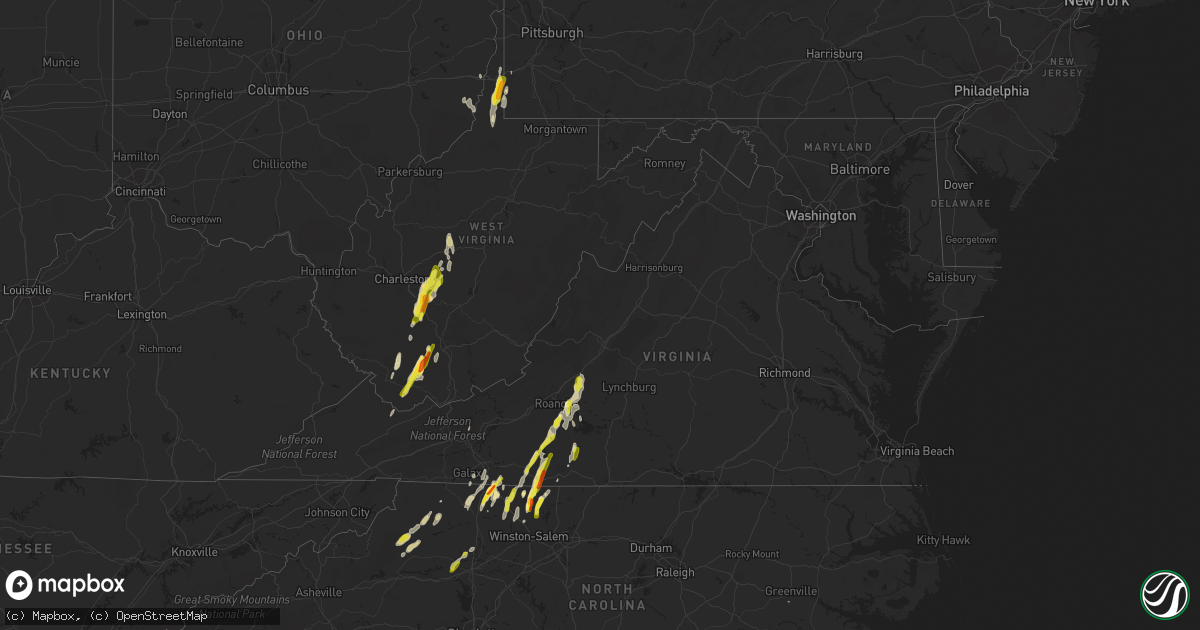
September 29 map
$229
one time, instant access
Download today. No call, no setup
Keep the $229
Bought the map and want the full workflow? Apply the entire $229 to a subscription within 7 days. None of it is wasted.
Every map, not just this one
This buys you this map. Subscription and you get every map we run, in the markets you choose from a few cities to whole states to nationwide. Plus real-time alerts the moment a storm fires.
Contact data
Name, contact info, occupancy, even credit band for addresses in the footprint. You go from where it hit to who to call.
Become the source they trust
Unlimited branding weather history reports on demand. You already have the documented answer ready for the property owner, and you are the one who showed up with it.
Property data and RoofTrace estimates
Pull up any address you have got, its value and the exact code rules for that jurisdiction, straight from One Click Code. Then RoofTrace estimates the squares, pitch, and roof value, priced the way you price.
Storm reports in Virginia
Virginia
| Date | Description |
|---|---|
| 09/29/20166:54 PM CDT | Tree down on the bluegrass trail |
| 09/29/20166:01 PM CDT | Tree down... Relayed by media |
| 09/29/20166:00 PM CDT | A large tree was blown down on listening hill road near novelty road. |
| 09/29/20165:43 PM CDT | A tree was blown down along breezy ridge road. |
| 09/29/20165:27 PM CDT | A tree was blown down along porters mountain road. |
| 09/29/20165:10 PM CDT | A local report indicates 1.25 inch wind near COOPERS COVE |
| 09/29/20164:38 PM CDT | A local report indicates 1.25 inch wind near 3 NNW BURNT CHIMNEY |
| 09/29/20164:15 PM CDT | Quarter size hail fell along fall creek road. |
| 09/29/20164:01 PM CDT | Relayed by media |
| 09/29/20163:36 PM CDT | A tree was blown down along heidelback school road. |
| 09/29/20162:10 PM CDT | *** 1 fatal *** tree fell on a pickup truck on a driveway killing one man outside the vehicle. |
| 09/29/20162:06 PM CDT | A local report indicates 1.00 inch wind near 2 W ARARAT |
| 09/29/20161:51 PM CDT | A tree was blown down along burks fork road. |
| 09/29/20161:43 PM CDT | A tree was blown down along dugspur road near the intersection with silver leaf road. |
| 09/29/20166:45 AM CDT | A local report indicates 1.25 inch wind near 3 W CRITZ |
| 09/29/20166:30 AM CDT | Two trees down on mill creek road |
| 09/28/20167:00 PM CDT | Tree down on big hill rd. |
All States Impacted by Hail Map on September 29, 2016
Cities Impacted by Hail Map on September 29, 2016
- Cameron, WV
- New Martinsville, WV
- West Finley, PA
- Madison, NC
- Walnut Cove, NC
- Sandy Ridge, NC
- Max Meadows, VA
- Wind Ridge, PA
- Oracle, AZ
- Tucson, AZ
- Mammoth, WV
- Glen, WV
- Indore, WV
- London, WV
- Blount, WV
- Drybranch, WV
- Clendenin, WV
- Glasgow, WV
- East Bank, WV
- Miami, WV
- Orgas, WV
- Belle, WV
- Bomont, WV
- Smithers, WV
- Eskdale, WV
- Lizemores, WV
- Hansford, WV
- Pratt, WV
- Montgomery, WV
- Pond Gap, WV
- Cedar Grove, WV
- Gallagher, WV
- Mayodan, NC
- Whiteriver, AZ
- Benson, AZ
- New Smyrna Beach, FL
- Lenoir, NC
- Purlear, NC
- Millers Creek, NC
- McGrady, NC
- Bassett, VA
- Mims, FL
- Mount Airy, NC
- Vinton, VA
- Montvale, VA
- Thaxton, VA
- Blue Ridge, VA
- Critz, VA
- Patrick Springs, VA
- Olin, NC
- Harmony, NC
- Pineville, WV
- New Richmond, WV
- Saulsville, WV
- Lester, WV
- Slab Fork, WV
- Glen Daniel, WV
- Brenton, WV
- Clear Fork, WV
- Lawsonville, NC
- Stuart, VA
- Spencer, VA
- Itmann, WV
- Maben, WV
- Paynesville, WV
- Welch, WV
- Herndon, WV
- Cyclone, WV
- Oceana, WV
- Iaeger, WV
- Laurel Springs, NC
- Danbury, NC
- Germanton, NC
- Westfield, NC
- Clifton, AZ
- Blue, AZ
- Saint David, AZ
- Winterville, NC
- Naoma, WV
- Wharton, WV
- Johnsonville, SC
- Varnville, SC
- Islandton, SC
- Ruffin, SC
- Pearce, AZ
- Chloe, WV
- Hardy, VA
- Goodview, VA
- Boones Mill, VA
- Pooler, GA
- Savannah, GA
- Whitesville, WV
- Orlando, FL
- Bedford, VA
- Roanoke, VA
- Newton, WV
- Orma, WV
- Procious, WV
- Wallback, WV
- Thurmond, NC
- Dobson, NC
- Rocky Mount, VA
- Wirtz, VA
- Wheeling, WV
- Triadelphia, WV
- Moundsville, WV
- Glen Easton, WV
- Dallas, WV
- Ridgeland, SC
- Estill, SC
- Early Branch, SC
- Walterboro, SC
- Yemassee, SC
- Pineland, SC
- Bridgeport, OH
- Ferrum, VA
- Osteen, FL
- Cana, VA
- Fancy Gap, VA
- Lambsburg, VA
- Princewick, WV
- Rhodell, WV
- Midway, WV
- Sophia, WV
- Willcox, AZ
- Martinsville, VA
- Bandy, VA
- Jewell Ridge, VA
- Pilot Mountain, NC
- Pinnacle, NC
- Beallsville, OH
- Jacobsburg, OH
- Alledonia, OH
- Proctor, WV
- Clarington, OH
- Powhatan Point, OH
- Callaway, VA
- Penhook, VA
- Claysville, PA
- Edgewater, FL
- Galax, VA
- Fairdale, WV
- Moneta, VA
- Collettsville, NC
- Cubero, NM
- Mount Lemmon, AZ
- Henry, VA
- Tobaccoville, NC
- King, NC
- Buchanan, VA
- Lowgap, NC
- Ararat, VA
- Richlands, VA
- Deep Gap, NC
- Ferguson, NC
- Clay, WV
- Maysel, WV
- Statesville, NC
- Valley Grove, WV
- Littleton, WV
- East Bend, NC
- Meeteetse, WY
- Orange City, FL
- Boone, NC
- Elkin, NC
- Ararat, NC
- Claudville, VA
- Ridgeway, VA
- Aleppo, PA
- Rural Hall, NC
- Stoneville, NC
- Bickmore, WV
- Hugheston, WV
- Geneva, FL
- Cochise, AZ
- Stony Point, NC
- Hiddenite, NC
- Mullens, WV
- State Road, NC
- West Alexander, PA
- Callands, VA
- Sylvester, WV
- Handley, WV
- Beckley, WV
- Surveyor, WV


