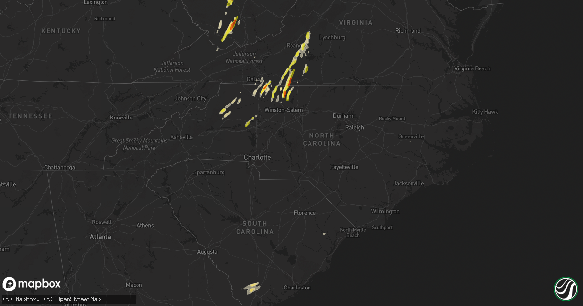
Hail Map in North Carolina on September 29, 2016
Get this storm
September 29 map
$229
one time, instant access
Download today. No call, no setup
Keep the $229
Bought the map and want the full workflow? Apply the entire $229 to a subscription within 7 days. None of it is wasted.
Every map, not just this one
This buys you this map. Subscription and you get every map we run, in the markets you choose from a few cities to whole states to nationwide. Plus real-time alerts the moment a storm fires.
Contact data
Name, contact info, occupancy, even credit band for addresses in the footprint. You go from where it hit to who to call.
Become the source they trust
Unlimited branding weather history reports on demand. You already have the documented answer ready for the property owner, and you are the one who showed up with it.
Property data and RoofTrace estimates
Pull up any address you have got, its value and the exact code rules for that jurisdiction, straight from One Click Code. Then RoofTrace estimates the squares, pitch, and roof value, priced the way you price.
Storm reports in North Carolina
North Carolina
| Date | Description |
|---|---|
| 09/29/20166:54 PM CDT | A few trees down in east bend. |
| 09/29/20166:18 PM CDT | A few trees down in yadkinville. |
| 09/29/20164:38 PM CDT | Tree down on hwy 421 near watauga county border |
| 09/29/20164:30 PM CDT | 1/4 inch to 1 inch hail observed off hwy 90 e |
| 09/29/20164:04 PM CDT | A local report indicates 1.00 inch wind near 4 W DARBY |
| 09/29/20163:30 PM CDT | A local report indicates 1.00 inch wind near 2 SE MEADOWS |
| 09/29/20161:40 PM CDT | A local report indicates 1.00 inch wind near PILOT MOUNTAIN |
| 09/29/20161:40 PM CDT | A local report indicates 1.00 inch wind near 1 WSW PILOT MOUNTAIN |
| 09/29/20161:33 PM CDT | A local report indicates 1.75 inch wind near 2 WNW TOAST |
| 09/29/20166:04 AM CDT | A local report indicates 1.75 inch wind near WNW DANBURY |
| 09/29/20165:54 AM CDT | Tree down on dan george rd at p east rd. |
| 09/29/20162:35 AM CDT | Tree down on elledge mill road in mulberry area |
| 09/29/20162:30 AM CDT | Tree down on gentry street |
| 09/29/20162:30 AM CDT | Tree down on old farms rd in moravian falls area |
| 09/29/20162:30 AM CDT | Tree down on cemetery rd in moravian falls |
| 09/28/20168:16 PM CDT | One tree down on power line along worth st. |
All States Impacted by Hail Map on September 29, 2016
Cities Impacted by Hail Map on September 29, 2016
- Cameron, WV
- New Martinsville, WV
- West Finley, PA
- Madison, NC
- Walnut Cove, NC
- Sandy Ridge, NC
- Max Meadows, VA
- Wind Ridge, PA
- Oracle, AZ
- Tucson, AZ
- Mammoth, WV
- Glen, WV
- Indore, WV
- London, WV
- Blount, WV
- Drybranch, WV
- Clendenin, WV
- Glasgow, WV
- East Bank, WV
- Miami, WV
- Orgas, WV
- Belle, WV
- Bomont, WV
- Smithers, WV
- Eskdale, WV
- Lizemores, WV
- Hansford, WV
- Pratt, WV
- Montgomery, WV
- Pond Gap, WV
- Cedar Grove, WV
- Gallagher, WV
- Mayodan, NC
- Whiteriver, AZ
- Benson, AZ
- New Smyrna Beach, FL
- Lenoir, NC
- Purlear, NC
- Millers Creek, NC
- McGrady, NC
- Bassett, VA
- Mims, FL
- Mount Airy, NC
- Vinton, VA
- Montvale, VA
- Thaxton, VA
- Blue Ridge, VA
- Critz, VA
- Patrick Springs, VA
- Olin, NC
- Harmony, NC
- Pineville, WV
- New Richmond, WV
- Saulsville, WV
- Lester, WV
- Slab Fork, WV
- Glen Daniel, WV
- Brenton, WV
- Clear Fork, WV
- Lawsonville, NC
- Stuart, VA
- Spencer, VA
- Itmann, WV
- Maben, WV
- Paynesville, WV
- Welch, WV
- Herndon, WV
- Cyclone, WV
- Oceana, WV
- Iaeger, WV
- Laurel Springs, NC
- Danbury, NC
- Germanton, NC
- Westfield, NC
- Clifton, AZ
- Blue, AZ
- Saint David, AZ
- Winterville, NC
- Naoma, WV
- Wharton, WV
- Johnsonville, SC
- Varnville, SC
- Islandton, SC
- Ruffin, SC
- Pearce, AZ
- Chloe, WV
- Hardy, VA
- Goodview, VA
- Boones Mill, VA
- Pooler, GA
- Savannah, GA
- Whitesville, WV
- Orlando, FL
- Bedford, VA
- Roanoke, VA
- Newton, WV
- Orma, WV
- Procious, WV
- Wallback, WV
- Thurmond, NC
- Dobson, NC
- Rocky Mount, VA
- Wirtz, VA
- Wheeling, WV
- Triadelphia, WV
- Moundsville, WV
- Glen Easton, WV
- Dallas, WV
- Ridgeland, SC
- Estill, SC
- Early Branch, SC
- Walterboro, SC
- Yemassee, SC
- Pineland, SC
- Bridgeport, OH
- Ferrum, VA
- Osteen, FL
- Cana, VA
- Fancy Gap, VA
- Lambsburg, VA
- Princewick, WV
- Rhodell, WV
- Midway, WV
- Sophia, WV
- Willcox, AZ
- Martinsville, VA
- Bandy, VA
- Jewell Ridge, VA
- Pilot Mountain, NC
- Pinnacle, NC
- Beallsville, OH
- Jacobsburg, OH
- Alledonia, OH
- Proctor, WV
- Clarington, OH
- Powhatan Point, OH
- Callaway, VA
- Penhook, VA
- Claysville, PA
- Edgewater, FL
- Galax, VA
- Fairdale, WV
- Moneta, VA
- Collettsville, NC
- Cubero, NM
- Mount Lemmon, AZ
- Henry, VA
- Tobaccoville, NC
- King, NC
- Buchanan, VA
- Lowgap, NC
- Ararat, VA
- Richlands, VA
- Deep Gap, NC
- Ferguson, NC
- Clay, WV
- Maysel, WV
- Statesville, NC
- Valley Grove, WV
- Littleton, WV
- East Bend, NC
- Meeteetse, WY
- Orange City, FL
- Boone, NC
- Elkin, NC
- Ararat, NC
- Claudville, VA
- Ridgeway, VA
- Aleppo, PA
- Rural Hall, NC
- Stoneville, NC
- Bickmore, WV
- Hugheston, WV
- Geneva, FL
- Cochise, AZ
- Stony Point, NC
- Hiddenite, NC
- Mullens, WV
- State Road, NC
- West Alexander, PA
- Callands, VA
- Sylvester, WV
- Handley, WV
- Beckley, WV
- Surveyor, WV


