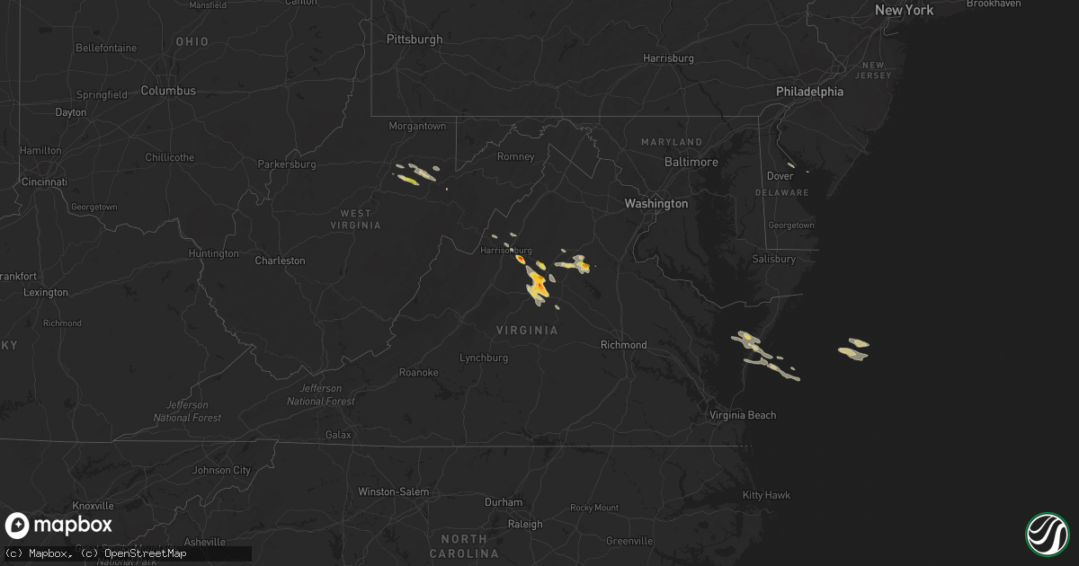
Hail Map on September 28, 2021
Get this storm
September 28 map
$229
one time, instant access
Download today. No call, no setup
Keep the $229
Bought the map and want the full workflow? Apply the entire $229 to a subscription within 7 days. None of it is wasted.
Every map, not just this one
This buys you this map. Subscription and you get every map we run, in the markets you choose from a few cities to whole states to nationwide. Plus real-time alerts the moment a storm fires.
Contact data
Name, contact info, occupancy, even credit band for addresses in the footprint. You go from where it hit to who to call.
Become the source they trust
Unlimited branding weather history reports on demand. You already have the documented answer ready for the property owner, and you are the one who showed up with it.
Property data and RoofTrace estimates
Pull up any address you have got, its value and the exact code rules for that jurisdiction, straight from One Click Code. Then RoofTrace estimates the squares, pitch, and roof value, priced the way you price.
States Impacted by Hail Map on September 28, 2021
Storm reports
Pennsylvania
| Date | Description |
|---|---|
| 09/28/20216:32 PM CDT | Shingles blown off a roof and minor tree damage in upper chichester township. Time estimated from radar. |
Oklahoma
| Date | Description |
|---|---|
| 09/28/20212:31 AM CDT | At 730 PM CDT, a severe thunderstorm was located 5 miles southeast of Snyder, moving northeast at 20 mph. HAZARD...60 mph wind gusts and quarter size hail. SOURCE...Radar indicated. IMPACT...Hail damage to vehicles is expected. Expect wind damage to roofs, siding, and trees. Locations impacted include... Western Lawton, Cache, Snyder, Indiahoma, southwestern Fort Sill and Wichita Mountains Wildlife Refuge. |
| 09/27/202111:02 PM CDT | At 402 PM CDT, a severe thunderstorm was located 7 miles southwest of Lone Grove, moving northeast at 10 mph. HAZARD...60 mph wind gusts and penny size hail. SOURCE...Radar indicated. IMPACT...Expect damage to roofs, siding, and trees. Locations impacted include... Ardmore, Lone Grove, Dickson and northwestern Lake Murray. |
| 09/27/20217:50 PM CDT | Power lines down and structure damage near chisholm corner in cache. |
| 09/27/20217:50 PM CDT | Gas station awning and partial roof damage due to a downburst. |
| 09/27/20217:04 PM CDT | Twitter photo and mping report. |
Delaware
| Date | Description |
|---|---|
| 09/28/20212:29 AM CDT | At 729 PM EDT, a severe thunderstorm was located over Chelsea, or 10 miles southeast of West Chester, moving southeast at 30 mph. HAZARD...60 mph wind gusts and quarter size hail. SOURCE...Radar indicated. IMPACT...Minor damage to vehicles is possible. Wind damage to roofs, siding, trees, and power lines is possible. Locations impacted include... Chester, Deptford, West Deptford, Glassboro, Woodbury, Pitman, Folcroft, Swarthmore, Paulsboro, Woodstown, Woodbury Heights, National Park, Swedesboro, Arden, Darby Township, Elam, Chelsea, Gradyville, Chester Township and Mullica Hill.This includes the following highways... New Jersey Turnpike near exit 2. Interstate 95 in Pennsylvania between mile markers 0 and 11. Interstate 95 in Delaware between mile markers 19 and 23. Interstate 295 in New Jersey between mile markers 7 and 23. Interstate 476 in Pennsylvania between mile markers 0 and 6. |
Virginia
| Date | Description |
|---|---|
| 09/28/20216:15 PM CDT | A local report indicates 1.00 inch wind near 1 SSW BARRACKS |
| 09/28/20215:17 PM CDT | A local report indicates 1.75 inch wind near 1 N CARRSBROOK |
| 09/28/20215:15 PM CDT | A local report indicates 1.00 inch wind near 1 NE CARRSBROOK |
| 09/28/20215:11 PM CDT | A local report indicates 1.00 inch wind near 1 SSE HOLLYMEAD |
| 09/28/20214:45 PM CDT | A local report indicates 1.25 inch wind near 1 NNE FIVE FORKS |
| 09/28/20214:40 PM CDT | A local report indicates 1.50 inch wind near 3 N EARLYSVILLE |
| 09/28/20214:36 PM CDT | A local report indicates 1.00 inch wind near 3 N EARLYSVILLE |
| 09/28/20214:05 PM CDT | A local report indicates 1.00 inch wind near 1 SSE MCMULLEN |
| 09/28/20214:00 PM CDT | A local report indicates 1.00 inch wind near 2 SW SWIFT RUN |
| 09/28/20213:58 PM CDT | Golfball hail size at 2000 block of shady acres drive in elkton. |
| 09/28/20213:51 PM CDT | A local report indicates 1.00 inch wind near 2 SE MASSANUTTEN |
| 09/28/20213:50 PM CDT | A local report indicates 1.00 inch wind near 1 SE MASSANUTTEN |
| 09/28/20212:02 AM CDT | At 702 PM EDT, a severe thunderstorm was located near Free Union, or near Charlottesville, moving southeast at 20 mph. HAZARD...Quarter size hail. SOURCE...Radar indicated. IMPACT...Some hail damage to agriculture is expected. Locations impacted include... Charlottesville, Free Union, Campbell, Westmoreland, Hollymead, Ivy, Cobham, Cismont, Newcomb Hall, Boyd Tavern, Monticello, Keswick, Stony Point, Flordon, Carrsbrook, Shadwell, Barracks, Overton and Scott Stadium. |
| 09/28/20211:08 AM CDT | At 607 PM EDT, a severe thunderstorm with a history of producing large hail was located near Charlottesville, moving southeast at 20 mph. HAZARD...Quarter size hail. SOURCE...Radar indicated. IMPACT...Some hail damage to agriculture is expected. Locations impacted include... Campbell, Westmoreland, Hollymead, Cobham, Cismont, Boyd Tavern, Keswick, Stony Point, Advance Mills, Carrsbrook and Earlysville. |
| 09/28/20211:02 AM CDT | At 602 PM EDT, a severe thunderstorm with a history of producing large hail was located 13 miles east of Orange, moving southeast at 20 mph. HAZARD...60 mph wind gusts and half dollar size hail. SOURCE...Radar indicated. IMPACT...Damaging winds will cause some trees and large branches to fall. This could injure those outdoors, as well as damage homes and vehicles. Roadways may become blocked by downed trees. Localized power outages are possible. Unsecured light objects may become projectiles. Locations impacted include... Massaponax, Spotsylvania, Brokenburg, Parker, Snell, Alsop, Gatewood, Logan, Partlow, Glenora, Post Oak, Thornburg and Cookstown. |
| 09/28/202112:40 AM CDT | At 540 PM EDT, a severe thunderstorm was located near Madison, moving east at 25 mph. HAZARD...Quarter size hail. SOURCE...Radar indicated. IMPACT...Some hail damage to agriculture is expected. Locations impacted include... Orange, Rhoadesville, Rapidan, Oakpark, Everona, Verdiersville, Pratts, Rochelle, Nasons, Aroda, Madison Mills, Montford, Lahore, Twymans Mill, Unionville and Locust Dale. |
| 09/28/202112:32 AM CDT | At 532 PM EDT, a severe thunderstorm was located near Culpeper, moving southeast at 15 mph. HAZARD...Quarter size hail. SOURCE...Radar indicated. IMPACT...Some hail damage to agriculture is expected. Locations impacted include... Gold Dale, Raccoon Ford, Mine Run, Winston, Mitchells, Lake Of The Woods, Burr Hill, Locust Grove and Flat Run. |
| 09/28/202112:27 AM CDT | At 527 PM EDT, a severe thunderstorm with a history of producing large hail was located near Stanardsville, or 14 miles north of Charlottesville, moving southeast at 20 mph. HAZARD...Quarter size hail. SOURCE...Trained weather spotters. IMPACT...Some hail damage to agriculture is expected. Locations impacted include... Hollymead, Ruckersville, Quinque, Boonesville, Eheart, Amicus, Barboursville, Stony Point, Advance Mills, Saint George, Earlysville and Shady Grove. |
| 09/27/202111:43 PM CDT | At 443 PM EDT, a severe thunderstorm was located over Massanutten, or 10 miles east of Harrisonburg, moving southeast at 25 mph. HAZARD...60 mph wind gusts and quarter size hail. SOURCE...Radar indicated. IMPACT...Damaging winds will cause some trees and large branches to fall. This could injure those outdoors, as well as damage homes and vehicles. Roadways may become blocked by downed trees. Localized power outages are possible. Unsecured light objects may become projectiles. Locations impacted include... Massanutten, Stanardsville, Elkton, Ruckersville, Mcmullen, Rocky Bar, Quinque, Lydia, Haneytown, Mission Home, Swift Run, Amicus, Mcgaheysville, Saint George, Shady Grove and Montevideo. |
| 09/27/20218:02 PM CDT | At 101 PM EDT, a severe thunderstorm was located 9 miles north of Dale Enterprise, or 12 miles northwest of Harrisonburg, moving southeast at 30 mph. HAZARD...60 mph wind gusts and quarter size hail. SOURCE...Radar indicated. IMPACT...Damaging winds will cause some trees and large branches to fall. This could injure those outdoors, as well as damage homes and vehicles. Roadways may become blocked by downed trees. Localized power outages are possible. Unsecured light objects may become projectiles. Locations impacted include... Harrisonburg, Shenandoah, Massanutten, Dale Enterprise, Dayton, Penn Laird, Cherry Grove, Lacey Spring, Singers Glen, Linville, Keezletown, Hinton, Montevideo and Sparkling Springs. |
West Virginia
| Date | Description |
|---|---|
| 09/28/20219:54 AM CDT | A few trees reported down along seneca trail/rte 219. |
| 09/28/20219:40 AM CDT | Spotter reported nickel to quarter sized hail and sent us a video along with a picture. |
| 09/28/20215:49 AM CDT | At 1049 AM EDT, a severe thunderstorm was located 8 miles northwest of Parsons, moving east at 30 mph. HAZARD...Quarter size hail. SOURCE...Radar indicated. IMPACT...Minor damage to vehicles is possible. Locations impacted include... Saint George and Pifer Moutain. |
| 09/28/20215:46 AM CDT | At 1046 AM EDT, a severe thunderstorm was located 8 miles northeast of Philippi, moving east at 25 mph. HAZARD...60 mph wind gusts and quarter size hail. SOURCE...Radar indicated. IMPACT...Hail damage to vehicles is expected. Expect wind damage to roofs, siding, and trees. Locations impacted include... Nestorville and Moatsville. |
| 09/28/20215:03 AM CDT | At 1003 AM EDT, a severe thunderstorm was located near Philippi, moving east at 35 mph. HAZARD...60 mph wind gusts and quarter size hail. SOURCE...Radar indicated. IMPACT...Hail damage to vehicles is expected. Expect wind damage to roofs, siding, and trees. Locations impacted include... Philippi, Belington, Montrose, Kerens, Volga and Nestorville. |
Texas
| Date | Description |
|---|---|
| 09/28/20216:30 PM CDT | Media reports of 1 inch hail in odem. Time was estimated from radar. |
| 09/28/20212:45 AM CDT | At 745 PM CDT, a severe thunderstorm was located near Florence, or 9 miles north of Serenada, moving southeast at 25 mph. HAZARD...60 mph wind gusts. SOURCE...Radar indicated. IMPACT...Expect damage to roofs, siding, and trees. Locations impacted include... Georgetown, Taylor, Granger, Serenada, Bartlett, Jarrell, Florence, Weir, Granger Dam, Andice, Sun City, Theon, Waterloo, Walburg, Schwertner and Jonah. |
| 09/28/20211:37 AM CDT | At 637 PM CDT, a severe thunderstorm was located over Calallen, or near Robstown, and is nearly stationary. HAZARD...60 mph wind gusts and quarter size hail. SOURCE...Radar indicated. IMPACT...Hail damage to vehicles is expected. Expect wind damage to roofs, siding, and trees. Locations impacted include... Corpus Christi, Robstown, Sinton, Odem, San Patricio, Edroy, Annaville, Calallen and Tuloso.This includes the following highways... Interstate 37 between mile markers 7 and 25. US Highway 181 near mile marker 620. US Highway 77 between mile markers 646 and 658. |
| 09/28/20211:31 AM CDT | At 631 PM CDT, a severe thunderstorm was located 14 miles south of Dabney, or 14 miles west of La Pryor, moving northeast at 15 mph. HAZARD...Quarter size hail. SOURCE...Radar indicated. IMPACT...Damage to vehicles is expected. This severe thunderstorm will remain over mainly rural areas of northeastern Maverick and northwestern Zavala Counties. |
| 09/28/202112:53 AM CDT | The krnd asos reported a wind gust of 59 mph. |
| 09/27/202111:16 PM CDT | At 416 PM CDT, a severe thunderstorm was located near Jacksboro, moving northeast at 15 mph. HAZARD...60 mph wind gusts and quarter size hail. SOURCE...Radar indicated. IMPACT...Hail damage to vehicles is expected. Expect wind damage to roofs, siding, and trees. Locations impacted include... Jacksboro and Newport. |
| 09/27/202110:39 PM CDT | At 339 PM CDT, a severe thunderstorm was located near Oak Trail Shores, or 10 miles north of Granbury, moving northeast at 20 mph. HAZARD...60 mph wind gusts and quarter size hail. SOURCE...Radar indicated. IMPACT...Hail damage to vehicles is expected. Expect wind damage to roofs, siding, and trees. Locations impacted include... Weatherford, Willow Park, Aledo, Hudson Oaks, Annetta, Annetta South and Annetta North.This includes Interstate 20 between mile markers 404 and 420. |
Massachusetts
| Date | Description |
|---|---|
| 09/28/20215:02 AM CDT | At 1001 AM EDT, a severe thunderstorm was located over Whitman, or over Brockton, moving east at 35 mph. HAZARD...Quarter size hail. SOURCE...Radar indicated. IMPACT...Minor hail damage to vehicles is possible. Locations impacted include... Boston, Brockton, Quincy, Newton, Brookline, Weymouth, Braintree, Randolph, Needham, Norwood, Milton, Stoughton, Bridgewater, Marshfield, Dedham, Easton, Hingham, Canton, Scituate and Pembroke. |
| 09/27/20219:07 PM CDT | At 207 PM EDT, a severe thunderstorm was located over Newport, moving northeast at 40 mph. HAZARD...60 mph wind gusts. SOURCE...Radar indicated. IMPACT...Expect damage to trees and power lines. Locations impacted include... New Bedford, Fall River, Plymouth, Barnstable, Dartmouth, Falmouth, Newport, Bristol, Marion, Middleborough, Wareham, Sandwich, Bourne, Portsmouth, Middletown, Fairhaven, Tiverton, Westport, Mashpee and Carver. |
Rhode Island
| Date | Description |
|---|---|
| 09/28/202112:34 PM CDT | Wind gust measured in the watch hill section of westerly |
| 09/28/20214:29 AM CDT | At 928 AM EDT, a severe thunderstorm was located over Woonsocket, moving northeast at 35 mph. HAZARD...Quarter size hail. SOURCE...Radar indicated. IMPACT...Minor hail damage to vehicles is possible. Locations impacted include... Boston, Worcester, Quincy, Newton, Framingham, Waltham, Brookline, Weymouth, Arlington, Woonsocket, Braintree, Shrewsbury, Cumberland, Natick, Randolph, Watertown, Franklin, Lexington, Needham and North Attleborough. |
Cities Impacted by Hail Map on September 28, 2021
- Belle Haven, VA
- Graford, TX
- Junction, TX
- Fredericksburg, TX
- Llano, TX
- Mason, TX
- Doss, TX
- Harper, TX
- Ruckersville, VA
- Stanardsville, VA
- Brady, TX
- Rochelle, TX
- Mullin, TX
- Weatherford, TX
- Lipan, TX
- Olney, TX
- Throckmorton, TX
- Newcastle, TX
- Evant, TX
- Bandera, TX
- Charlottesville, VA
- Scottsville, VA
- Dyke, VA
- Earlysville, VA
- Elkton, VA
- McGaheysville, VA
- Eagle Pass, TX
- La Pryor, TX
- Quemado, TX
- Crystal City, TX
- Sunset, TX
- Chico, TX
- Lometa, TX
- Philippi, WV
- Saint Jo, TX
- Nocona, TX
- Star, TX
- Hamilton, TX
- Goldthwaite, TX
- Overbrook, OK
- San Saba, TX
- Fredonia, TX
- Keswick, VA
- Granbury, TX
- Ranger, TX
- Burnet, TX
- Jacksboro, TX
- Strawn, TX
- Barboursville, VA
- Free Union, VA
- Ryan, OK
- Bluff Dale, TX
- Sweetwater, TX
- Roby, TX
- Sylvester, TX
- Wilson, OK
- Ringling, OK
- Bowie, TX
- Eldorado, TX
- Christoval, TX
- Henrietta, TX
- Windthorst, TX
- Quanah, TX
- Perrin, TX
- San Marcos, TX
- Wimberley, TX
- Fischer, TX
- Driftwood, TX
- Comanche, OK
- Odem, TX
- Terral, OK
- Moran, TX
- Cisco, TX
- Breckenridge, TX
- Woonsocket, RI
- Manville, RI
- North Smithfield, RI
- Plainville, MA
- Cumberland, RI
- Indiahoma, OK
- Cache, OK
- Bellevue, TX
- Foxboro, MA
- Mansfield, MA
- Montrose, WV
- Parsons, WV
- Grafton, WV
- Moatsville, WV
- Menard, TX
- North Windham, CT
- Canyon Lake, TX
- Spring Branch, TX
- Burneyville, OK
- Leon, OK
- Crozet, VA
- Sinton, TX
- Volga, WV
- Belington, WV
- San Antonio, TX
- Helotes, TX
- Graham, TX
- Tolar, TX
- Stephenville, TX
- Gustine, TX
- Dublin, TX
- Exmore, VA
- Rapidan, VA
- Radiant, VA
- Orange, VA
- Locust Dale, VA
- Duncan, OK
- Culpeper, VA
- Rhoadesville, VA
- Unionville, VA
- Hanksville, UT
- San Angelo, TX
- Baird, TX
- Cross Plains, TX
- Painter, VA
- Dilley, TX
- Colorado City, TX
- Kerrville, TX
- Taft, TX
- Mathis, TX
- Caddo, TX
- Boerne, TX
- Holliday, TX
- Coleman, TX
- North Attleboro, MA
- Wrentham, MA
- Lincoln, RI
- Snyder, OK
- Frederick, OK
- Palmyra, VA
- Troy, VA
- Muenster, TX
- Gordonsville, VA
- South Bend, TX
- Lampasas, TX
- Mitchells, VA
- Ardmore, OK
- Lawton, OK
- Brookesmith, TX
- Brownwood, TX
- Medina, TX
- Jermyn, TX
- Bryson, TX
- Bridgeport, TX
- Bronte, TX
- Harrisonburg, VA
- Vernon, TX
- Crowell, TX
- Richland Springs, TX
- Yorktown, TX
- Hunt, TX
- Hico, TX
- Salado, TX
- Gainesville, TX
- Marietta, OK
- Forestburg, TX
- Fulks Run, VA
- Lohn, TX
- Ringgold, TX
- Spicewood, TX
- Marble Falls, TX
- Leander, TX
- Loving, TX
- New Braunfels, TX
- Keezletown, VA
- Hacksneck, VA
- Leon, VA
- Reva, VA
- Brightwood, VA
- Aroda, VA
- Rochelle, VA
- Mount Clare, WV
- Ferron, UT
- Pontotoc, TX
- Voca, TX
- Robstown, TX
- Corpus Christi, TX
- Hockley, TX
- Broadway, VA
- Woodson, TX
- Bertram, TX
- Hendricks, WV
- Cape Charles, VA
- Machipongo, VA
- Locust Grove, VA
- Madison, VA
- Harrisville, RI
- Flemington, WV
- Bridgeport, WV
- Cedar Park, TX