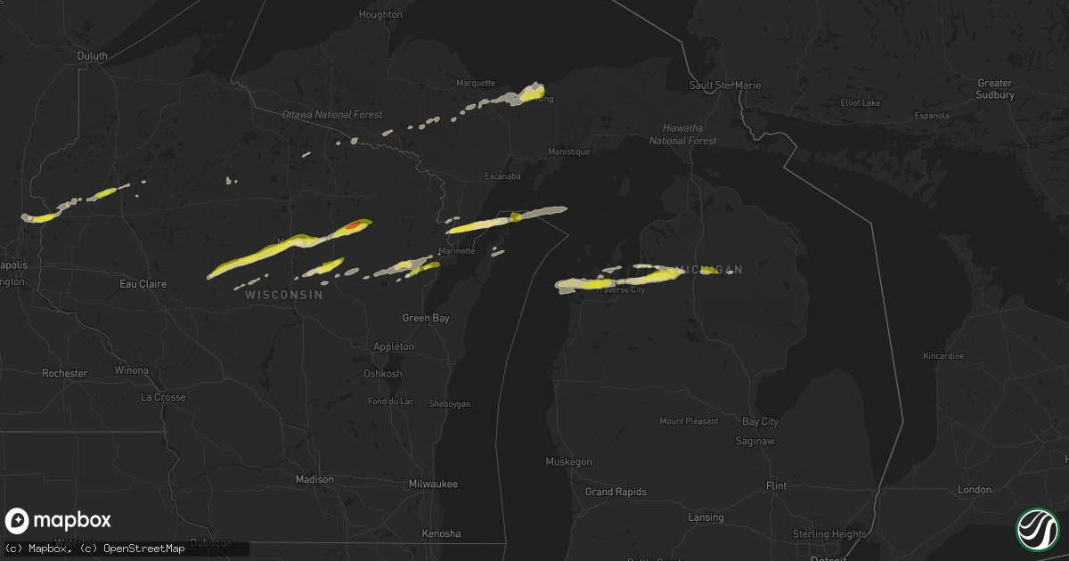
Hail Map in Michigan on September 26, 2020
Get this storm
September 26 map
$229
one time, instant access
Download today. No call, no setup
Keep the $229
Bought the map and want the full workflow? Apply the entire $229 to a subscription within 7 days. None of it is wasted.
Every map, not just this one
This buys you this map. Subscription and you get every map we run, in the markets you choose from a few cities to whole states to nationwide. Plus real-time alerts the moment a storm fires.
Contact data
Name, contact info, occupancy, even credit band for addresses in the footprint. You go from where it hit to who to call.
Become the source they trust
Unlimited branding weather history reports on demand. You already have the documented answer ready for the property owner, and you are the one who showed up with it.
Property data and RoofTrace estimates
Pull up any address you have got, its value and the exact code rules for that jurisdiction, straight from One Click Code. Then RoofTrace estimates the squares, pitch, and roof value, priced the way you price.
Storm reports in Michigan
Michigan
| Date | Description |
|---|---|
| 09/26/202010:50 AM CDT | A local report indicates 1.00 inch wind near 9 SSE GAYLORD |
| 09/26/20209:08 AM CDT | Report from mping: half dollar |
| 09/26/20209:05 AM CDT | Facebook post with picture of quarter size hail in mancelona. |
| 09/26/20208:54 AM CDT | Ham radio operator relayed reported of quarter size hail. |
| 09/26/20208:04 AM CDT | A local report indicates 1.00 inch wind near CEDAR |
| 09/26/20207:16 AM CDT | At 1216 PM EDT, a severe thunderstorm was located near Loud Township, or near Lewiston, moving east at 40 mph. HAZARD...60 mph wind gusts and quarter size hail. SOURCE...Radar indicated. IMPACT...Hail damage to vehicles is expected. Expect wind damage to roofs, siding, and trees. Locations impacted include... Lewiston, Comins, Fletcher Pond, Lockwood Lake, Loud Township, Spratt and Mitchell Township. |
| 09/26/20206:37 AM CDT | At 1137 AM EDT, a severe thunderstorm was located over Waters, or 9 miles south of Gaylord, moving east at 35 mph. HAZARD...60 mph wind gusts and quarter size hail. SOURCE...Radar indicated. IMPACT...Hail damage to vehicles is expected. Expect wind damage to roofs, siding, and trees. Locations impacted include... Lewiston, Lovells, Otsego Lake State Park, Chester Township, Waters and Garland. |
| 09/26/20205:23 AM CDT | At 1023 PM EDT, a severe thunderstorm was located over Miners Castle, moving northeast at 55 mph. HAZARD...Quarter size hail. SOURCE...Radar indicated. IMPACT...Damage to vehicles is expected. Locations impacted include... Munising, Grand Island, Miners Castle, Chapel Lake, Grand Sable Dunes, Beaver Lake, Melstrand, Grand Portal Point, Au Sable Point and Kingston Lake. |
| 09/26/20205:14 AM CDT | At 1013 AM EDT, a severe thunderstorm was located near Mancelona, moving east at 45 mph. HAZARD...Ping pong ball size hail. SOURCE...Radar indicated. At 1008 AM EDT, half dollar size hail was reported in Mancelona. IMPACT...People and animals outdoors will be injured. Expect damage to roofs, siding, windows, and vehicles. Locations impacted include... Gaylord, Sparr, Otsego Lake State Park, Chester Township, Alba, Johannesburg and Waters. |
| 09/26/20204:38 AM CDT | At 936 AM EDT, a severe thunderstorm was located near Williamsburg, or near Elk Rapids, moving east at 40 mph. HAZARD...Quarter size hail. SOURCE...Radar indicated. At 930 AM EDT, nickel sized hail was reported 4 miles NW of Traverse City. IMPACT...Damage to vehicles is expected. Locations impacted include... Traverse City, Kalkaska, Elk Rapids, Mancelona, Antrim, Clam River, Barker Creek, Kewadin, Rapid City, Alden, Mapleton, Darragh, Traverse City State Park, Williamsburg, Bates, Blue Lake Township and Lake Bellaire. |
| 09/26/20203:29 AM CDT | At 829 AM EDT, a severe thunderstorm was located 7 miles west of Empire, moving east at 30 mph. HAZARD...Quarter size hail. SOURCE...Radar indicated. IMPACT...Damage to vehicles is expected. Locations impacted include... Traverse City, Empire, Bingham, Glen Arbor, Suttons Bay, Cedar, Greilickville, Lake Leelanau, Burdickville, Maple City, Platte Township, Glen Haven, Peshawbestown, Fouch and Good Harbor. |
| 09/26/20202:12 AM CDT | At 712 PM CDT, a severe thunderstorm was located near Kentuck Lake Campground, or 13 miles southwest of Iron River, moving east at 50 mph. HAZARD...Quarter size hail. SOURCE...Radar indicated. IMPACT...Damage to vehicles is expected. Locations impacted include... Tipler, Wisconsin Slough Natural Area, Whisker Lake Wilderness, Kentuck Lake Campground, Alvin, Luna-White Deer Campground, Franklin Lake Campground, Nelma, Windsor Dam Campground and Stevens Lake Campground. |
| 09/25/202011:09 PM CDT | At 409 PM CDT, severe thunderstorms were located along a line extending from near Crivitz to Oconto, moving east at 65 mph. HAZARD...Quarter size hail. SOURCE...Trained weather spotters. IMPACT...Damage to vehicles is expected. Locations impacted include... Marinette, Menominee, Oconto, Crivitz, Pound, Peshtigo, Porterfield, Beaver, Coleman and Harmony. |
| 09/25/20209:32 PM CDT | At 231 AM EDT, a severe thunderstorm was located near Bliss, or 8 miles northwest of Pellston, moving east at 40 mph. HAZARD...Quarter size hail. SOURCE...Radar indicated. IMPACT...Damage to vehicles is possible. Locations impacted include... Cheboygan, Pellston, Carp Lake, Bliss, Cross Village, Cheboygan State Park, Alverno, Levering, Mullet Lake and Riggsville. |
| 09/25/20209:24 PM CDT | Public report via facebook image. Time confirmed with radar. |
Cities Impacted by Hail Map on September 26, 2020
- Cecil, WI
- Kewadin, MI
- Luck, WI
- Shafer, MN
- Taylors Falls, MN
- Dresser, WI
- Lindstrom, MN
- Saint Croix Falls, WI
- Center City, MN
- Edgar, WI
- Gwinn, MI
- Cedar, MI
- Maple City, MI
- Long Lake, WI
- Iron River, MI
- Glen Arbor, MI
- Honor, MI
- Traverse City, MI
- Lake Ann, MI
- Empire, MI
- Wallace, MI
- Menominee, MI
- Porterfield, WI
- Rapid City, MI
- Bellaire, MI
- Alden, MI
- Mancelona, MI
- Williamsburg, MI
- Birnamwood, WI
- Dorchester, WI
- Curtiss, WI
- Owen, WI
- Withee, WI
- Rice Lake, WI
- Birchwood, WI
- Negaunee, MI
- Gaylord, MI
- Johannesburg, MI
- Frederic, MI
- Washington Island, WI
- Merrill, WI
- Cumberland, WI
- Barronett, WI
- Gresham, WI
- Shawano, WI
- Munising, MI
- Marathon, WI
- Abbotsford, WI
- Athens, WI
- Antigo, WI
- Foster City, MI
- Suring, WI
- Lena, WI
- Gillett, WI
- Deerbrook, WI
- Colby, WI
- Bryant, WI
- Greenwood, WI
- Pickerel, WI
- White Lake, WI
- Stetsonville, WI
- Au Train, MI
- Kalkaska, MI
- Balsam Lake, WI
- Ringle, WI
- Hatley, WI
- Wyoming, MN
- Osceola, WI
- Stacy, MN
- Milltown, WI
- Chisago City, MN
- Centuria, WI
- Oconto Falls, WI
- Oconto, WI
- Skandia, MI
- Channing, MI
- Comstock, WI
- Schofield, WI
- Phillips, WI
- Fish Creek, WI
- Baileys Harbor, WI
- Phelps, WI
- Saint Germain, WI
- Crystal Falls, MI
- Lewiston, MI
- Bowler, WI
- Mosinee, WI
- Rothschild, WI
- Deerton, MI
- Chatham, MI
- Rumely, MI
- Eben Junction, MI
- Wausaukee, WI
- Keshena, WI
- Coleman, WI
- Stephenson, MI
- Ingalls, MI
- Wittenberg, WI
- Stratford, WI
- Elmira, MI
- Sarona, WI
- Gleason, WI
- Spencer, WI
- Loyal, WI
- Eland, WI
- Peshtigo, WI
- Lake Leelanau, MI
- Suttons Bay, MI
- Aniwa, WI
- Mattoon, WI


