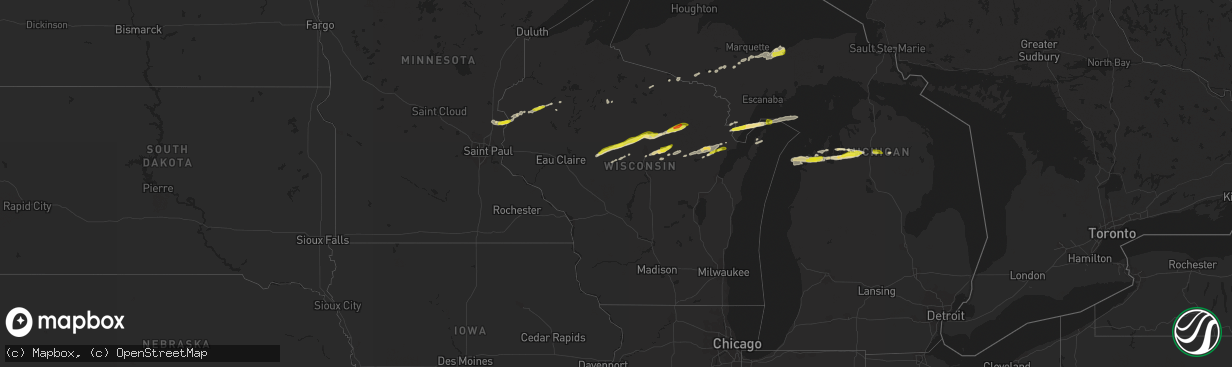
Hail Map in Wisconsin on September 26, 2020
The weather event in Wisconsin on September 26, 2020 includes Hail map. 3 states and 110 cities were impacted and suffered possible damage. The total estimated number of properties impacted is 14,688.
Want more than just the map?
Turn this storm into a full workflow.
- Owner + property data so you know who to knock
- OnDemand branded weather history reports to win the "did we even have hail?" argument
- RoofTrace estimate so reps stop guessing numbers at the door
Bought this map? Upgrade within 7 days and we'll credit the $230. (10-15 min setup call)
Hail
14,688
Estimated number of impacted properties by a 1.00" hail or larger121
Estimated number of impacted properties by a 1.75" hail or larger0
Estimated number of impacted properties by a 2.50" hail or largerStorm reports in Wisconsin
Wisconsin
| Date | Description |
|---|---|
| 09/26/20205:18 PM CDT | A picture of large hail north of dresser... Wisconsin. Estimated by surrounding objects. |
| 09/26/20203:59 PM CDT | A local report indicates 1.25 inch wind near 3 S HICKORY CORNERS |
| 09/26/20203:40 PM CDT | One inch hail for approximately 5 minutes. |
| 09/26/20203:40 PM CDT | Report received via social media. |
| 09/26/20203:38 PM CDT | A local report indicates 1.00 inch wind near 2 E MERRILL |
| 09/26/20203:04 PM CDT | A local report indicates 1.25 inch wind near 1 N BIRNAMWOOD |
| 09/26/20202:14 AM CDT | At 714 PM CDT, a severe thunderstorm was located 9 miles northeast of Phelps, or 12 miles west of Iron River, moving northeast at 50 mph. HAZARD...Quarter size hail. SOURCE...Radar indicated. IMPACT...Damage to vehicles is expected. Locations impacted include... Iron River, Crystal Falls, Stambaugh, Amasa, U.S. 141 between Covington and Amasa, Caspian, Gaastra, Alpha, Hagerman Lake, Golden Lake, Mineral Hills and Bewabic State Park. |
| 09/26/202012:33 AM CDT | At 532 PM CDT, a severe thunderstorm was located near Cedar River, or 19 miles northeast of Menominee, moving east at 60 mph. HAZARD...Half dollar size hail. SOURCE...Radar indicated. IMPACT...Damage to vehicles is expected. Locations impacted include... Washington Island, Rock Island State Park and Ellison Bay. |
| 09/26/202012:24 AM CDT | At 524 PM CDT, a severe thunderstorm was located 8 miles southeast of Stephenson, or 12 miles north of Menominee, moving east at 55 mph. HAZARD...Half dollar size hail. SOURCE...Radar indicated. IMPACT...Damage to vehicles is expected. Locations impacted include... Cedar River, Arthur Bay, Wallace and Carbondale. |
| 09/25/202011:13 PM CDT | At 413 PM CDT, a severe thunderstorm was located near Pearson, or 13 miles northeast of Antigo, moving east at 55 mph. HAZARD...Half dollar size hail. SOURCE...Radar indicated. IMPACT...Damage to vehicles is expected. Locations impacted include... Carter, McCaslin Mountain Natural Area, Pearson, Veterans Memorial County Park, Ma Ka Ja Wan Scout Reservation, Wabeno, Townsend, Freeman, Athelstane and Silver Cliff. |
| 09/25/202010:09 PM CDT | At 308 PM CDT, a severe thunderstorm was located 13 miles east of Dorchester, or 14 miles east of Medford, moving east at 60 mph. HAZARD...Half dollar size hail. SOURCE...Radar indicated. IMPACT...Damage to vehicles is expected. Locations impacted include... Merrill, Parrish, Birch Trails Girl Scout Camp, Council Grounds State Park, Dutch Corners, Athens, Rib Falls, Hamburg, Neva and Summit Lake. |
| 09/25/202010:00 PM CDT | At 259 PM CDT, a severe thunderstorm was located 10 miles northwest of Wittenberg, or 14 miles southwest of Antigo, moving northeast at 60 mph. HAZARD...Quarter size hail. SOURCE...Radar indicated. IMPACT...Damage to vehicles is expected. Locations impacted include... Antigo, Wittenberg, Mountain, White Lake, Big Smokey Falls, Bear Paw Scout Camp, Gardner Dam Scout Camp, Neopit, South Branch and Langlade. |
Cities Impacted by Hail Map on September 26, 2020
- Cecil, WI
- Kewadin, MI
- Luck, WI
- Shafer, MN
- Taylors Falls, MN
- Dresser, WI
- Lindstrom, MN
- Saint Croix Falls, WI
- Center City, MN
- Edgar, WI
- Gwinn, MI
- Cedar, MI
- Maple City, MI
- Long Lake, WI
- Iron River, MI
- Glen Arbor, MI
- Honor, MI
- Traverse City, MI
- Lake Ann, MI
- Empire, MI
- Wallace, MI
- Menominee, MI
- Porterfield, WI
- Rapid City, MI
- Bellaire, MI
- Alden, MI
- Mancelona, MI
- Williamsburg, MI
- Birnamwood, WI
- Dorchester, WI
- Curtiss, WI
- Owen, WI
- Withee, WI
- Rice Lake, WI
- Birchwood, WI
- Negaunee, MI
- Gaylord, MI
- Johannesburg, MI
- Frederic, MI
- Washington Island, WI
- Merrill, WI
- Cumberland, WI
- Barronett, WI
- Gresham, WI
- Shawano, WI
- Munising, MI
- Marathon, WI
- Abbotsford, WI
- Athens, WI
- Antigo, WI
- Foster City, MI
- Suring, WI
- Lena, WI
- Gillett, WI
- Deerbrook, WI
- Colby, WI
- Bryant, WI
- Greenwood, WI
- Pickerel, WI
- White Lake, WI
- Stetsonville, WI
- Au Train, MI
- Kalkaska, MI
- Balsam Lake, WI
- Ringle, WI
- Hatley, WI
- Wyoming, MN
- Osceola, WI
- Stacy, MN
- Milltown, WI
- Chisago City, MN
- Centuria, WI
- Oconto Falls, WI
- Oconto, WI
- Skandia, MI
- Channing, MI
- Comstock, WI
- Schofield, WI
- Phillips, WI
- Fish Creek, WI
- Baileys Harbor, WI
- Phelps, WI
- Saint Germain, WI
- Crystal Falls, MI
- Lewiston, MI
- Bowler, WI
- Mosinee, WI
- Rothschild, WI
- Deerton, MI
- Chatham, MI
- Rumely, MI
- Eben Junction, MI
- Wausaukee, WI
- Keshena, WI
- Coleman, WI
- Stephenson, MI
- Ingalls, MI
- Wittenberg, WI
- Stratford, WI
- Elmira, MI
- Sarona, WI
- Gleason, WI
- Spencer, WI
- Loyal, WI
- Eland, WI
- Peshtigo, WI
- Lake Leelanau, MI
- Suttons Bay, MI
- Aniwa, WI
- Mattoon, WI


