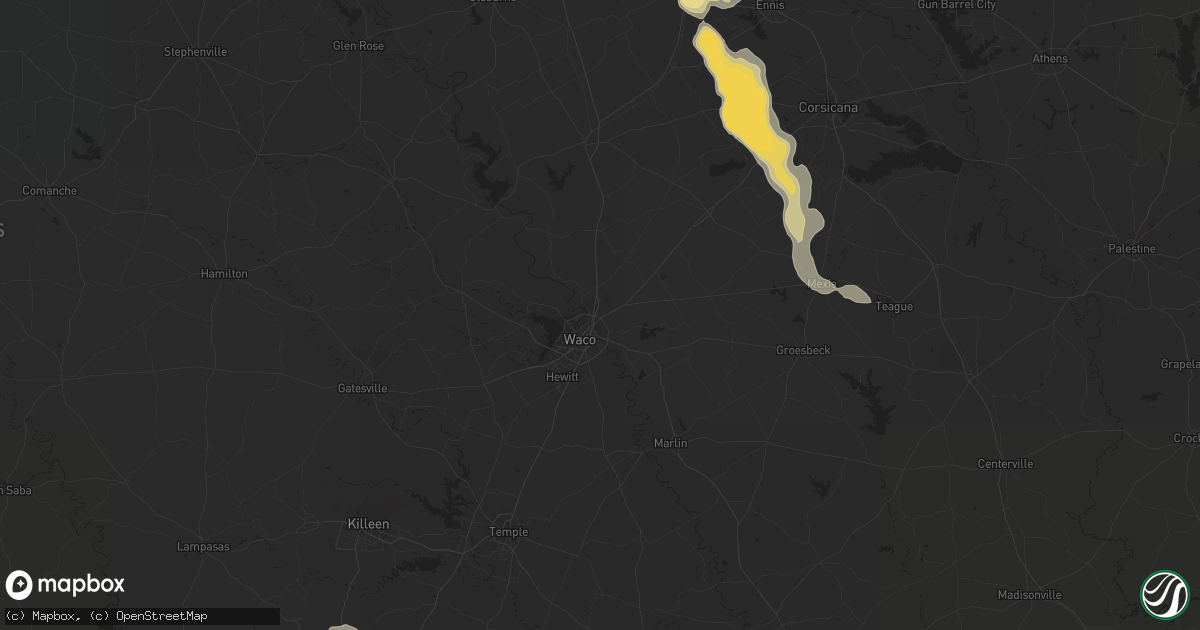
Hail Map in Round Rock, TX on September 24, 2023
Get this storm
September 24 map
$229
one time, instant access
Download today. No call, no setup
Keep the $229
Bought the map and want the full workflow? Apply the entire $229 to a subscription within 7 days. None of it is wasted.
Every map, not just this one
This buys you this map. Subscription and you get every map we run, in the markets you choose from a few cities to whole states to nationwide. Plus real-time alerts the moment a storm fires.
Contact data
Name, contact info, occupancy, even credit band for addresses in the footprint. You go from where it hit to who to call.
Become the source they trust
Unlimited branding weather history reports on demand. You already have the documented answer ready for the property owner, and you are the one who showed up with it.
Property data and RoofTrace estimates
Pull up any address you have got, its value and the exact code rules for that jurisdiction, straight from One Click Code. Then RoofTrace estimates the squares, pitch, and roof value, priced the way you price.
Storm reports in Round Rock, TX
Round Rock, TX
| Date | Description |
|---|---|
| 09/23/20239:27 PM CDT | Corrects previous hail report from 1 w round rock. Report from mping. |
| 09/23/20239:27 PM CDT | Report from mping grapefruit. |
| 09/23/20239:20 PM CDT | A local report indicates 2.25 inch wind near 1 ENE Brushy Creek |
| 09/23/20239:18 PM CDT | Intersection of cr 172 and tx 45. |
| 09/23/20239:17 PM CDT | Public report of hail up to the size of ping pong balls. |
| 09/23/20239:15 PM CDT | Intersection of heather drive and highway 79. |
| 09/23/20239:13 PM CDT | A local report indicates 1.75 inch wind near 2 S Round Rock |
| 09/23/20239:09 PM CDT | Time estimated via radar. Public submitted a report of a large tree down in round rock off chisholm valley drive. |
| 09/23/20239:08 PM CDT | A local report indicates 1.75 inch wind near 2 SW Round Rock |
| 09/23/20239:06 PM CDT | Report from mping golf ball. |
| 09/23/20239:03 PM CDT | Intersection of 620 and o connor drive. |
| 09/23/20239:03 PM CDT | Report from mping quarter. |
| 09/23/20239:03 PM CDT | Report from mping quarter. |
| 09/23/20239:01 PM CDT | A local report indicates 1.75 inch wind near 3 N Brushy Creek |
| 09/23/20239:00 PM CDT | 3 inch hail measured near intersection of tx 45 and i-35 around 9 pm. |
| 09/23/20238:58 PM CDT | Intersection of bowman dr and sunrise rd. |
| 09/23/20238:57 PM CDT | Numerous vehicles damaged with broken windows... Windshields at the kia dealership and from around round rock. Time estimated via radar. |
| 09/23/20238:54 PM CDT | A local report indicates 2.75 inch wind near 3 N Round Rock |
| 09/23/20238:52 PM CDT | Intersection of fm 1431 and i-35. |
| 09/23/20238:50 PM CDT | Hail ranging in size from pea to golf ball near the intersection of sam bass road and old settlers boulevard. |
All States Impacted by Hail Map on September 24, 2023
All Cities Impacted by Hail Map on September 24, 2023
- Plain Dealing, LA
- Coldspring, TX
- Cleveland, TX
- Willis, TX
- Leonard, TX
- Wolfe City, TX
- Bonham, TX
- Ladonia, TX
- New Waverly, TX
- Evansville, AR
- Canehill, AR
- Saint James, LA
- Donaldsonville, LA
- Darrow, LA
- Broussard, LA
- Saint Martinville, LA
- Livingston, LA
- Tahlequah, OK
- Miami, FL
- Covington, LA
- Kiefer, OK
- Sapulpa, OK
- Marathon, TX
- Fort Stockton, TX
- Dallas, TX
- Richardson, TX
- Garland, TX
- Sachse, TX
- Rowlett, TX
- Wylie, TX
- Arlington, TX
- Grand Prairie, TX
- Cedar Hill, TX
- Commerce, TX
- Klondike, TX
- Campbell, TX
- Cumby, TX
- Montalba, TX
- Palestine, TX
- Tennessee Colony, TX
- Midlothian, TX
- Red Oak, TX
- Waxahachie, TX
- Greenville, TX
- Troy, TX
- Eddy, TX
- Killeen, TX
- Briggs, TX
- Florence, TX
- Forreston, TX
- Ennis, TX
- Temple, TX
- Belton, TX
- Salado, TX
- Italy, TX
- Point, TX
- Emory, TX
- Lone Oak, TX
- Blooming Grove, TX
- Barry, TX
- Frost, TX
- Alba, TX
- Edgewood, TX
- Fruitvale, TX
- Grand Saline, TX
- Georgetown, TX
- Rogers, TX
- Holland, TX
- Buckholts, TX
- Bartlett, TX
- Corsicana, TX
- Purdon, TX
- Round Rock, TX
- Thorndale, TX
- Duncanville, TX
- Desoto, TX
- Paducah, TX
- Childress, TX
- Matador, TX
- Rockdale, TX
- Austin, TX
- Mineola, TX
- Van, TX
- Wortham, TX
- Richland, TX
- Dawson, TX
- Pflugerville, TX
- Granger, TX
- Taylor, TX
- Terrell, TX
- Quinlan, TX
- Wills Point, TX
- Lindale, TX
- Tyler, TX
- Davilla, TX
- Manor, TX
- Thrall, TX
- Mexia, TX
- Del Valle, TX
- Athens, TX
- Murchison, TX
- Larue, TX
- Chandler, TX
- Brownsboro, TX
- Frankston, TX
- Valley Mills, TX
- McGregor, TX
- Crawford, TX
- Mountainburg, AR
- Chester, AR
- Harper, TX
- Fredericksburg, TX
- Irving, TX
- Moody, TX
- Lorena, TX
- Woodway, TX
- China Spring, TX
- Little River Academy, TX
- Belle Rose, LA
- Doss, TX
- Gatesville, TX
- Oglesby, TX
- Bossier City, LA
- Haughton, LA
- Benton, LA
- Conroe, TX
- Kempner, TX
- Dixon, IA
- Walcott, IA
- Pierre Part, LA
- Napoleonville, LA
- Clifton, TX
- Euless, TX
- Bedford, TX
- Hurst, TX
- Junction, TX
- Johnson City, TX
- Fort Worth, TX
- Haltom City, TX
- Princeton, TX
- Honey Grove, TX
- Brookston, TX
- Sumner, TX
- Lampasas, TX
- London, TX
- Petty, TX
- Sorrento, LA
- Stilwell, OK
- Natural Dam, AR
- Mason, TX
- Windom, TX
- Calamus, IA
- Donahue, IA
- Royse City, TX
- Jarrell, TX
- Mansfield, TX
- Palmer, TX
- Farmersville, TX
- Youngsville, LA
- Rockwall, TX
- Fort Hood, TX
- Cameron, TX
- Aquilla, TX
- Caddo Mills, TX
- Llano, TX
- Elkhart, TX
- Hillsboro, TX
- Bennington, OK
- Bullard, TX
- Jacksonville, TX
- Rusk, TX
- Flint, TX
- Troup, TX
- Colbert, OK
- Calera, OK
- Hendrix, OK
- Durant, OK
- Boswell, OK
- Bokchito, OK
- Mountain Home, TX
- Ingram, TX
- Hunt, TX
- Eustace, TX
- Chilton, TX
- Grapevine, TX
- Colleyville, TX
- Alto, TX
- Moline, IL
- Onalaska, TX
- Celina, TX
- Ben Wheeler, TX
- Menard, TX
- Sonora, TX
- Eldorado, TX
- Kerrville, TX
- Waco, TX
- Wells, TX
- Grapeland, TX
- Castell, TX
- Cedar Park, TX
- Shreveport, LA
- Kennard, TX
- Pilot Point, TX
- Hewitt, TX
- Tioga, TX
- Collinsville, TX
- Art, TX
- Whitney, TX
- Elm Grove, LA
- The Colony, TX
- Carrollton, TX
- Linden, TX
- Avinger, TX
- West, TX
- Hugo, OK
- Marietta, TX
- Sherman, TX
- Leander, TX
- Harker Heights, TX
- Canton, TX
- Denison, TX
- Telephone, TX
- Comfort, TX
- Howe, TX
- Whitesboro, TX
- Henderson, TX
- Gainesville, TX
- Pointblank, TX
- Bruceville, TX
- Convent, LA
- Riesel, TX
- Mabank, TX
- Gunter, TX
- Lexington, TX
- Purmela, TX
- Jefferson, TX
- Karnack, TX
- Mooringsport, LA
- Vivian, LA
- Waskom, TX
- Copperas Cove, TX
- Barksdale Afb, LA
- Lott, TX
- Rocksprings, TX
- Plano, TX
- Allen, TX
- Pottsboro, TX
- Roosevelt, TX
- Balch Springs, TX
- Lancaster, TX
- Axtell, TX
- Willow City, TX
- Medina, TX
- Fort McKavett, TX
- Mesquite, TX
- Mount Calm, TX
- Livingston, TX
- Ferris, TX
- Brashear, TX
- Christoval, TX
- Bandera, TX
- Valley Spring, TX
- Forney, TX
- Sunnyvale, TX
- Hondo, TX
- Elm Mott, TX
- Leakey, TX


