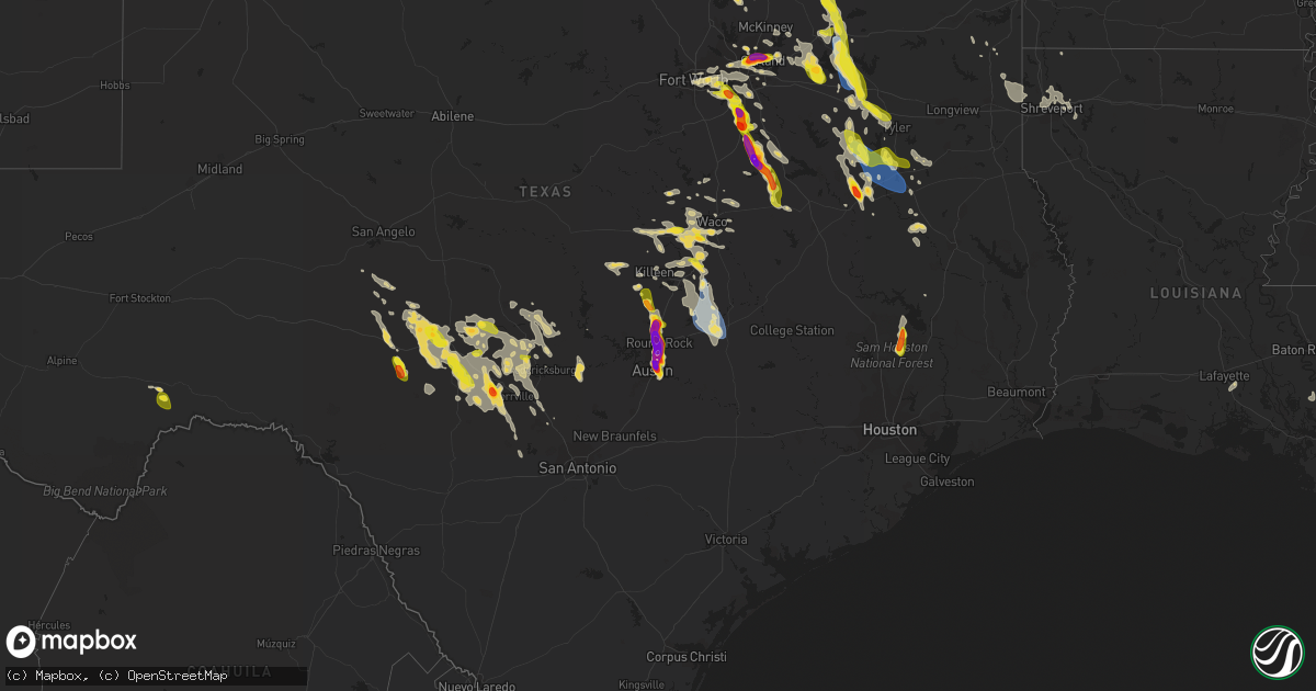
Hail Map on September 24, 2023
Get this storm
September 24 map
$229
one time, instant access
Download today. No call, no setup
Keep the $229
Bought the map and want the full workflow? Apply the entire $229 to a subscription within 7 days. None of it is wasted.
Every map, not just this one
This buys you this map. Subscription and you get every map we run, in the markets you choose from a few cities to whole states to nationwide. Plus real-time alerts the moment a storm fires.
Contact data
Name, contact info, occupancy, even credit band for addresses in the footprint. You go from where it hit to who to call.
Become the source they trust
Unlimited branding weather history reports on demand. You already have the documented answer ready for the property owner, and you are the one who showed up with it.
Property data and RoofTrace estimates
Pull up any address you have got, its value and the exact code rules for that jurisdiction, straight from One Click Code. Then RoofTrace estimates the squares, pitch, and roof value, priced the way you price.
Storm reports
Florida
| Date | Description |
|---|---|
| 09/23/202311:15 PM CDT | An off-duty nws employee reported large limbs downed from laurel oak trees in the kendalltown neighborhood. Time estimated from radar. |
| 09/23/202311:02 PM CDT | A member of the public shared video of a large downed tree blocking a neighborhood street near zoo miami. Time estimated from radar. |
| 09/23/20237:17 PM CDT | A southwesterly wind gust of 51 kts... Or 59 mph... Was recorded by the key west international airport asos at 8:17 pm edt. |
Texas
| Date | Description |
|---|---|
| 09/24/20236:59 PM CDT | Report from mping: hen egg |
| 09/24/20236:57 PM CDT | Report from mping: half dollar |
| 09/24/20236:56 PM CDT | Report from mping: quarter |
| 09/24/20236:55 PM CDT | Trees and tree limbs down in commerce. Some stop signs and power lines were also knocked down. |
| 09/24/20236:55 PM CDT | A local report indicates 2.25 inch wind near 1 SSE Richardson |
| 09/24/20236:53 PM CDT | Report from mping: golf ball |
| 09/24/20236:50 PM CDT | Corrects previous hail report from 2 n garland. 2 and 2.25 inch hail was reported via mping and the public. |
| 09/24/20236:48 PM CDT | A local report indicates 1.75 inch wind near 1 ESE Buckingham |
| 09/24/20236:48 PM CDT | Report from mping: quarter |
| 09/24/20236:48 PM CDT | Report from mping: ping pong ball |
| 09/24/20236:48 PM CDT | Kact 24036g52kt. |
| 09/24/20236:45 PM CDT | The metal roof was taken off a city storage barn. Winds are estimated to be around 60 mph. |
| 09/24/20236:44 PM CDT | Report from mping: half dollar |
| 09/24/20236:39 PM CDT | Ping pong ball sized hail was reported for 4 minutes near the intersection of s. Lois lane and spring valley in richardson... Tx. |
| 09/24/20236:37 PM CDT | Report from mping: half dollar |
| 09/24/20236:36 PM CDT | Report from mping: half dollar |
| 09/24/20236:28 PM CDT | Report from mping: half dollar |
| 09/24/20236:15 PM CDT | Delayed report. Trees were uprooted and snapped in half. Several other trees were downed west of lake waco. |
| 09/24/20235:04 PM CDT | Quarter sized hail was reported. |
| 09/24/20234:55 PM CDT | Trees and power lines downed all across the fm 1725 and fm 945 areas. |
| 09/24/20234:35 PM CDT | Multiple trees down in and around highway 150. |
| 09/24/20233:15 AM CDT | At least 10 trees and some power poles reported down on highway 16 between bandera and medina from overnight storms. Photos show several large 1 to 2 foot diameter tree |
| 09/24/20233:14 AM CDT | Personal weather station near 3240 and panther hollow drive measured 60 mph gusts overnight. |
| 09/24/20233:09 AM CDT | Rock cliff reservoir weather station measured a 65 mph gust overnight. |
| 09/24/202312:40 AM CDT | Tree down at the corner of 1818 and cc road. |
| 09/24/202312:00 AM CDT | Time estimated via radar. |
| 09/23/202311:33 PM CDT | A tree was blown down across fm 225 just north of laneville. A vehicle struck the tree... But the driver was not injured. |
| 09/23/202311:30 PM CDT | Corrects previous tstm wnd dmg report from 6 n reklaw. A roof was ripped off of a house on cr 4256 on the rusk county side of lake striker. |
| 09/23/202311:30 PM CDT | A 70 mph wind gust was measured at a texas water development board mesonet station on the rusk county side of lake striker. |
| 09/23/202311:25 PM CDT | Roof removed from an outbuilding and one exterior wall blown out of another outbuilding near the intersection of fm 1798 and fm 839. |
| 09/23/202311:23 PM CDT | Numerous trees down across highway 84 near cr 1204 northeast of rusk. Trees down on structures in the area. A vehicle hit a tree lying across the roadway... But the dri |
| 09/23/202311:21 PM CDT | A roof was ripped off of a house on cr 4256 on the rusk county side of lake striker. |
| 09/23/202311:15 PM CDT | Tree down on fm1324. |
| 09/23/202311:15 PM CDT | Tree down on fm2683. |
| 09/23/202311:00 PM CDT | Numerous trees and power lines were downed across northern cherokee county... Including along highway 79 between highways 204 and 110. A tree fell onto a home in jackso |
| 09/23/202310:55 PM CDT | A local report indicates 1.50 inch wind near Lorena |
| 09/23/202310:44 PM CDT | Report from mping hen egg. |
| 09/23/202310:39 PM CDT | Quarter hail in poyner. |
| 09/23/202310:39 PM CDT | Quarter hail in poyner. |
| 09/23/202310:35 PM CDT | Numerous trees down across the city of tyler and smith county. |
| 09/23/202310:29 PM CDT | Report from mping tennis ball. |
| 09/23/202310:19 PM CDT | 1.5 inch hail measured via picture from x. |
| 09/23/202310:17 PM CDT | 2.50 inch measured hail in central austin via picture via x. |
| 09/23/202310:17 PM CDT | Via x. |
| 09/23/202310:11 PM CDT | A local report indicates 1.00 inch wind near 4 NE Austin |
| 09/23/202310:10 PM CDT | Via x. |
| 09/23/202310:10 PM CDT | Report from mping tennis ball. |
| 09/23/202310:10 PM CDT | Measured via x from brentwood area in austin. |
| 09/23/202310:08 PM CDT | Intersection of 38th st and duval st. |
| 09/23/202310:07 PM CDT | Hail up to slightly larger than golf balls occurred 1000 pm through 1015pm. 2 home windows broken. Car windshield cracked with some minor dents noted on vehicle. Near i |
| 09/23/202310:05 PM CDT | Report from mping hen egg+. |
| 09/23/202310:00 PM CDT | Golf ball size hail near intersection of lamar blvd and burnet. |
| 09/23/20239:57 PM CDT | Report from mping quarter. |
| 09/23/20239:55 PM CDT | 3 inch hail reported on burnet ln in brentwood via x. |
| 09/23/20239:50 PM CDT | Picture of 2 to 2.25 inch hail near hyde park via x. |
| 09/23/20239:50 PM CDT | 6 inch diameter tree blown down. |
| 09/23/20239:49 PM CDT | Report from mping quarter. |
| 09/23/20239:47 PM CDT | Report from mping quarter. |
| 09/23/20239:42 PM CDT | Delayed report. Report from mping: half dollar |
| 09/23/20239:40 PM CDT | Hail up to the size of golf balls near the intersection of north lamar boulevard and highway 183. |
| 09/23/20239:40 PM CDT | A local report indicates 1.00 inch wind near 3 SE Waxahachie |
| 09/23/20239:35 PM CDT | Report from mping quarter. |
| 09/23/20239:31 PM CDT | Report from mping hen egg. |
| 09/23/20239:31 PM CDT | Report from mping quarter. |
| 09/23/20239:30 PM CDT | A local report indicates 1.25 inch wind near 5 S Wells Branch |
| 09/23/20239:30 PM CDT | Several trees down near hwy110 and fm16. |
| 09/23/20239:29 PM CDT | Report from mping: quarter |
| 09/23/20239:27 PM CDT | Report from mping grapefruit. |
| 09/23/20239:27 PM CDT | Corrects previous hail report from 1 w round rock. Report from mping. |
| 09/23/20239:26 PM CDT | A local report indicates 62 MPH wind near 10 SW Paducah |
| 09/23/20239:26 PM CDT | 2.25 inch hail in red oak. |
| 09/23/20239:25 PM CDT | Report from mping quarter. |
| 09/23/20239:24 PM CDT | A local report indicates 58 MPH wind near 10 SW Paducah |
| 09/23/20239:23 PM CDT | Several large 4 to 5 inch limbs were blown down on floral park drive just west of jollyville road. Trees limbs blocking sidewalk and bike lanes. |
| 09/23/20239:23 PM CDT | A local report indicates 2.00 inch wind near 2 SSW Wells Branch |
| 09/23/20239:22 PM CDT | Report from mping ping pong ball. |
| 09/23/20239:22 PM CDT | Amateur radio report of ping pong ball sized hail at metric boulevard and braker lane. |
| 09/23/20239:21 PM CDT | Quarters to golf ball sized hail. |
| 09/23/20239:20 PM CDT | Delayed report. Damage to the roof of a store building in seaton... Tx. |
| 09/23/20239:20 PM CDT | Report from mping tea cup. |
| 09/23/20239:20 PM CDT | A local report indicates 2.25 inch wind near 1 ENE Brushy Creek |
| 09/23/20239:18 PM CDT | Report from mping quarter. |
| 09/23/20239:18 PM CDT | Intersection of cr 172 and tx 45. |
| 09/23/20239:17 PM CDT | Public report of hail up to the size of ping pong balls. |
| 09/23/20239:15 PM CDT | Intersection of heather drive and highway 79. |
| 09/23/20239:14 PM CDT | Personal weather station just west of the kerr/kendall county line measured a 60 mph wind gust yesterday evening. |
| 09/23/20239:13 PM CDT | Falling for last 5 minutes. |
| 09/23/20239:13 PM CDT | Report from mping quarter. |
| 09/23/20239:13 PM CDT | Report from mping: quarter |
| 09/23/20239:13 PM CDT | A local report indicates 1.75 inch wind near 2 S Round Rock |
| 09/23/20239:12 PM CDT | Report from mping: quarter |
| 09/23/20239:11 PM CDT | Report from mping: quarter |
| 09/23/20239:09 PM CDT | Time estimated via radar. Public submitted a report of a large tree down in round rock off chisholm valley drive. |
| 09/23/20239:08 PM CDT | A local report indicates 1.75 inch wind near 2 SW Round Rock |
| 09/23/20239:06 PM CDT | Report from mping golf ball. |
| 09/23/20239:03 PM CDT | Report from mping quarter. |
| 09/23/20239:03 PM CDT | Report from mping quarter. |
| 09/23/20239:03 PM CDT | Intersection of 620 and o connor drive. |
| 09/23/20239:01 PM CDT | A local report indicates 1.75 inch wind near 3 N Brushy Creek |
| 09/23/20239:00 PM CDT | 3 inch hail measured near intersection of tx 45 and i-35 around 9 pm. |
| 09/23/20238:58 PM CDT | Intersection of bowman dr and sunrise rd. |
| 09/23/20238:57 PM CDT | Numerous vehicles damaged with broken windows... Windshields at the kia dealership and from around round rock. Time estimated via radar. |
| 09/23/20238:54 PM CDT | A local report indicates 2.75 inch wind near 3 N Round Rock |
| 09/23/20238:53 PM CDT | Report from mping: quarter |
| 09/23/20238:52 PM CDT | Intersection of fm 1431 and i-35. |
| 09/23/20238:50 PM CDT | Several trees down. |
| 09/23/20238:50 PM CDT | Hail ranging in size from pea to golf ball near the intersection of sam bass road and old settlers boulevard. |
| 09/23/20238:50 PM CDT | A local report indicates 2.25 inch wind near 1 SSE Georgetown |
| 09/23/20238:49 PM CDT | A local report indicates 1.00 inch wind near 2 ESE Serenada |
| 09/23/20238:45 PM CDT | A local report indicates 1.00 inch wind near 3 W Duncanville |
| 09/23/20238:45 PM CDT | A local report indicates 1.75 inch wind near 1 SSE Georgetown |
| 09/23/20238:44 PM CDT | A local report indicates 1.75 inch wind near 1 SW Serenada |
| 09/23/20238:43 PM CDT | Report from mping quarter. |
| 09/23/20238:39 PM CDT | Lots of quarter size hail along leander road around 1/2 mile sw of bypass. |
| 09/23/20238:38 PM CDT | A local report indicates 59 MPH wind near 1 S Northfield |
| 09/23/20238:35 PM CDT | A local report indicates 2.50 inch wind near 2 SW Georgetown |
| 09/23/20238:34 PM CDT | Report by texas water development board automated site. |
| 09/23/20238:32 PM CDT | Amateur radio report of dime to quarter sized hail near the intersection of serenada drive and williams drive. |
| 09/23/20238:32 PM CDT | Amateur radio report of dime to quarter sized hail near the intersection of serenada drive and williams drive. |
| 09/23/20238:30 PM CDT | A local report indicates 2.75 inch wind near Blooming Grove |
| 09/23/20238:27 PM CDT | A local report indicates 1.75 inch wind near Blooming Grove |
| 09/23/20238:26 PM CDT | Report from mping: trees uprooted or snapped; roof blown off. |
| 09/23/20238:25 PM CDT | Power lines down and major tree damage on the nw side of emory... Tx on hwy 69. |
| 09/23/20238:22 PM CDT | A local report indicates 1.25 inch wind near 3 NW Grand Prairie |
| 09/23/20238:20 PM CDT | Delayed report. Outdoor shed was completely taken away. 5th wheel camper was lifted and thrown onto garage. Second 5th wheel camper was moved with damage. |
| 09/23/20238:15 PM CDT | Emory fire station reporting flagpoles bowing over... Small limbs blowing across parking lot... Bay doors of fire station bowing in. |
| 09/23/20238:10 PM CDT | Delayed report. Metal roof damaged in zabcikville... Tx. |
| 09/23/20238:00 PM CDT | Trees and tree limbs were down on fm 514 and needed to cleared off the roadway. |
| 09/23/20237:50 PM CDT | Public report of quarter hail at the intersection of tomlinson street and patterson avenue. |
| 09/23/20237:50 PM CDT | A local report indicates 1.75 inch wind near 5 NNW Blooming Grove |
| 09/23/20237:45 PM CDT | A local report indicates 1.00 inch wind near 3 SE Waxahachie |
| 09/23/20237:40 PM CDT | Location and time estimated via radar. |
| 09/23/20237:38 PM CDT | A local report indicates 1.75 inch wind near 2 ENE Waxahachie |
| 09/23/20237:36 PM CDT | Power lines down between commerce and ladonia on state highway 50. |
| 09/23/20237:35 PM CDT | Corrects location. Delayed report. Quarter size hail reported in tigertown. |
| 09/23/20237:31 PM CDT | Report from mping: quarter |
| 09/23/20237:30 PM CDT | Delayed report. Quarter size hail reported in tigertown. |
| 09/23/20237:28 PM CDT | Report from mping: 3-inch tree limbs broken; power poles broken. |
| 09/23/20237:21 PM CDT | Report from mping: quarter |
| 09/23/20237:17 PM CDT | Corrects previous hail report from 4 wnw palestine. Hail up to 2 inches was reported near the columbia scientific balloon facility. |
| 09/23/20237:17 PM CDT | Golf ball hail reported on fm 3224 near balloon facility. |
| 09/23/20237:05 PM CDT | 1-2 inch hail was reported near plano rd and belt line via mping and trained spotters. |
Louisiana
| Date | Description |
|---|---|
| 09/24/20237:22 AM CDT | Trees down near shreveport blanchard road and north industry road near blanchard louisiana. |
| 09/24/202312:45 AM CDT | Several trees down scattered across portions of the parish. |
| 09/24/202312:15 AM CDT | Numerous tr |
| 09/24/202312:15 AM CDT | Several trees were downed in stonewall. |
| 09/24/202312:15 AM CDT | Numerous trees and power lines were downed across the south highlands neighborhood of shreveport... Including near pierremont ave and gilbert drive... And ockley drive |
| 09/24/202312:13 AM CDT | A 66 mph |
| 09/24/202312:13 AM CDT | Trees and power lines were downed on jewella ave between dollarway drive and red bud lane. |
| 09/24/202312:05 AM CDT | Trees down over colquitt road between scout drive and woolworth road. |
| 09/24/202312:00 AM CDT | A tree was downed on buncombe road near bert kouns industrial loop. Another tree was also downed on bert kouns near pines road. |
| 09/23/202311:59 PM CDT | A tree was downed on woolworth road between sagewood drive and shirley francis road. |
| 09/23/202311:51 PM CDT | Trees were down across highway 169 between lindsay road and carrera street west of blanchard. |
| 09/23/202310:05 PM CDT | Multiple trees were blown down in the dogwood south subdivision just northeast of bossier city. Some trees were downed onto homes. |
Cities Impacted by Hail Map on September 24, 2023
- Plain Dealing, LA
- Coldspring, TX
- Cleveland, TX
- Willis, TX
- Leonard, TX
- Wolfe City, TX
- Bonham, TX
- Ladonia, TX
- New Waverly, TX
- Evansville, AR
- Canehill, AR
- Saint James, LA
- Donaldsonville, LA
- Darrow, LA
- Broussard, LA
- Saint Martinville, LA
- Livingston, LA
- Tahlequah, OK
- Miami, FL
- Covington, LA
- Kiefer, OK
- Sapulpa, OK
- Marathon, TX
- Fort Stockton, TX
- Dallas, TX
- Richardson, TX
- Garland, TX
- Sachse, TX
- Rowlett, TX
- Wylie, TX
- Arlington, TX
- Grand Prairie, TX
- Cedar Hill, TX
- Commerce, TX
- Klondike, TX
- Campbell, TX
- Cumby, TX
- Montalba, TX
- Palestine, TX
- Tennessee Colony, TX
- Midlothian, TX
- Red Oak, TX
- Waxahachie, TX
- Greenville, TX
- Troy, TX
- Eddy, TX
- Killeen, TX
- Briggs, TX
- Florence, TX
- Forreston, TX
- Ennis, TX
- Temple, TX
- Belton, TX
- Salado, TX
- Italy, TX
- Point, TX
- Emory, TX
- Lone Oak, TX
- Blooming Grove, TX
- Barry, TX
- Frost, TX
- Alba, TX
- Edgewood, TX
- Fruitvale, TX
- Grand Saline, TX
- Georgetown, TX
- Rogers, TX
- Holland, TX
- Buckholts, TX
- Bartlett, TX
- Corsicana, TX
- Purdon, TX
- Round Rock, TX
- Thorndale, TX
- Duncanville, TX
- Desoto, TX
- Paducah, TX
- Childress, TX
- Matador, TX
- Rockdale, TX
- Austin, TX
- Mineola, TX
- Van, TX
- Wortham, TX
- Richland, TX
- Dawson, TX
- Pflugerville, TX
- Granger, TX
- Taylor, TX
- Terrell, TX
- Quinlan, TX
- Wills Point, TX
- Lindale, TX
- Tyler, TX
- Davilla, TX
- Manor, TX
- Thrall, TX
- Mexia, TX
- Del Valle, TX
- Athens, TX
- Murchison, TX
- Larue, TX
- Chandler, TX
- Brownsboro, TX
- Frankston, TX
- Valley Mills, TX
- McGregor, TX
- Crawford, TX
- Mountainburg, AR
- Chester, AR
- Harper, TX
- Fredericksburg, TX
- Irving, TX
- Moody, TX
- Lorena, TX
- Woodway, TX
- China Spring, TX
- Little River Academy, TX
- Belle Rose, LA
- Doss, TX
- Gatesville, TX
- Oglesby, TX
- Bossier City, LA
- Haughton, LA
- Benton, LA
- Conroe, TX
- Kempner, TX
- Dixon, IA
- Walcott, IA
- Pierre Part, LA
- Napoleonville, LA
- Clifton, TX
- Euless, TX
- Bedford, TX
- Hurst, TX
- Junction, TX
- Johnson City, TX
- Fort Worth, TX
- Haltom City, TX
- Princeton, TX
- Honey Grove, TX
- Brookston, TX
- Sumner, TX
- Lampasas, TX
- London, TX
- Petty, TX
- Sorrento, LA
- Stilwell, OK
- Natural Dam, AR
- Mason, TX
- Windom, TX
- Calamus, IA
- Donahue, IA
- Royse City, TX
- Jarrell, TX
- Mansfield, TX
- Palmer, TX
- Farmersville, TX
- Youngsville, LA
- Rockwall, TX
- Fort Hood, TX
- Cameron, TX
- Aquilla, TX
- Caddo Mills, TX
- Llano, TX
- Elkhart, TX
- Hillsboro, TX
- Bennington, OK
- Bullard, TX
- Jacksonville, TX
- Rusk, TX
- Flint, TX
- Troup, TX
- Colbert, OK
- Calera, OK
- Hendrix, OK
- Durant, OK
- Boswell, OK
- Bokchito, OK
- Mountain Home, TX
- Ingram, TX
- Hunt, TX
- Eustace, TX
- Chilton, TX
- Grapevine, TX
- Colleyville, TX
- Alto, TX
- Moline, IL
- Onalaska, TX
- Celina, TX
- Ben Wheeler, TX
- Menard, TX
- Sonora, TX
- Eldorado, TX
- Kerrville, TX
- Waco, TX
- Wells, TX
- Grapeland, TX
- Castell, TX
- Cedar Park, TX
- Shreveport, LA
- Kennard, TX
- Pilot Point, TX
- Hewitt, TX
- Tioga, TX
- Collinsville, TX
- Art, TX
- Whitney, TX
- Elm Grove, LA
- The Colony, TX
- Carrollton, TX
- Linden, TX
- Avinger, TX
- West, TX
- Hugo, OK
- Marietta, TX
- Sherman, TX
- Leander, TX
- Harker Heights, TX
- Canton, TX
- Denison, TX
- Telephone, TX
- Comfort, TX
- Howe, TX
- Whitesboro, TX
- Henderson, TX
- Gainesville, TX
- Pointblank, TX
- Bruceville, TX
- Convent, LA
- Riesel, TX
- Mabank, TX
- Gunter, TX
- Lexington, TX
- Purmela, TX
- Jefferson, TX
- Karnack, TX
- Mooringsport, LA
- Vivian, LA
- Waskom, TX
- Copperas Cove, TX
- Barksdale Afb, LA
- Lott, TX
- Rocksprings, TX
- Plano, TX
- Allen, TX
- Pottsboro, TX
- Roosevelt, TX
- Balch Springs, TX
- Lancaster, TX
- Axtell, TX
- Willow City, TX
- Medina, TX
- Fort McKavett, TX
- Mesquite, TX
- Mount Calm, TX
- Livingston, TX
- Ferris, TX
- Brashear, TX
- Christoval, TX
- Bandera, TX
- Valley Spring, TX
- Forney, TX
- Sunnyvale, TX
- Hondo, TX
- Elm Mott, TX
- Leakey, TX