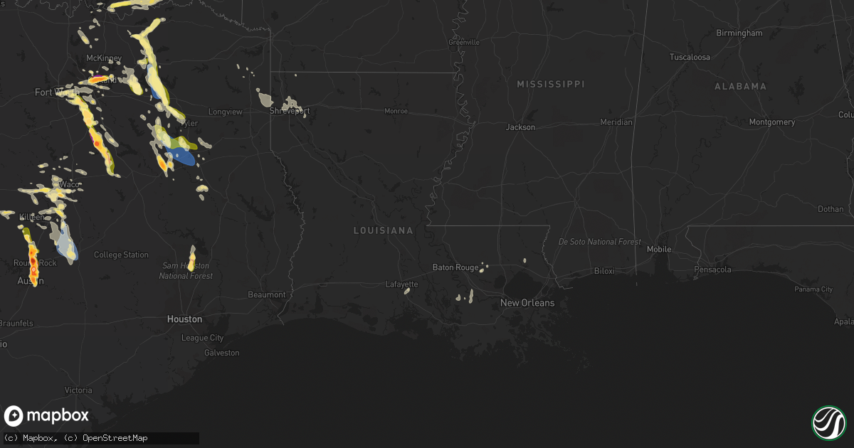
Hail Map in Louisiana on September 24, 2023
Get this storm
September 24 map
$229
one time, instant access
Download today. No call, no setup
Keep the $229
Bought the map and want the full workflow? Apply the entire $229 to a subscription within 7 days. None of it is wasted.
Every map, not just this one
This buys you this map. Subscription and you get every map we run, in the markets you choose from a few cities to whole states to nationwide. Plus real-time alerts the moment a storm fires.
Contact data
Name, contact info, occupancy, even credit band for addresses in the footprint. You go from where it hit to who to call.
Become the source they trust
Unlimited branding weather history reports on demand. You already have the documented answer ready for the property owner, and you are the one who showed up with it.
Property data and RoofTrace estimates
Pull up any address you have got, its value and the exact code rules for that jurisdiction, straight from One Click Code. Then RoofTrace estimates the squares, pitch, and roof value, priced the way you price.
Storm reports in Louisiana
Louisiana
| Date | Description |
|---|---|
| 09/24/20237:22 AM CDT | Trees down near shreveport blanchard road and north industry road near blanchard louisiana. |
| 09/24/202312:45 AM CDT | Several trees down scattered across portions of the parish. |
| 09/24/202312:15 AM CDT | Numerous trees and power lines were downed across the south highlands neighborhood of shreveport... Including near pierremont ave and gilbert drive... And ockley drive |
| 09/24/202312:15 AM CDT | Several trees were downed in stonewall. |
| 09/24/202312:15 AM CDT | Numerous tr |
| 09/24/202312:13 AM CDT | A 66 mph |
| 09/24/202312:13 AM CDT | Trees and power lines were downed on jewella ave between dollarway drive and red bud lane. |
| 09/24/202312:05 AM CDT | Trees down over colquitt road between scout drive and woolworth road. |
| 09/24/202312:00 AM CDT | A tree was downed on buncombe road near bert kouns industrial loop. Another tree was also downed on bert kouns near pines road. |
| 09/23/202311:59 PM CDT | A tree was downed on woolworth road between sagewood drive and shirley francis road. |
| 09/23/202311:51 PM CDT | Trees were down across highway 169 between lindsay road and carrera street west of blanchard. |
| 09/23/202310:05 PM CDT | Multiple trees were blown down in the dogwood south subdivision just northeast of bossier city. Some trees were downed onto homes. |
All States Impacted by Hail Map on September 24, 2023
Cities Impacted by Hail Map on September 24, 2023
- Plain Dealing, LA
- Coldspring, TX
- Cleveland, TX
- Willis, TX
- Leonard, TX
- Wolfe City, TX
- Bonham, TX
- Ladonia, TX
- New Waverly, TX
- Evansville, AR
- Canehill, AR
- Saint James, LA
- Donaldsonville, LA
- Darrow, LA
- Broussard, LA
- Saint Martinville, LA
- Livingston, LA
- Tahlequah, OK
- Miami, FL
- Covington, LA
- Kiefer, OK
- Sapulpa, OK
- Marathon, TX
- Fort Stockton, TX
- Dallas, TX
- Richardson, TX
- Garland, TX
- Sachse, TX
- Rowlett, TX
- Wylie, TX
- Arlington, TX
- Grand Prairie, TX
- Cedar Hill, TX
- Commerce, TX
- Klondike, TX
- Campbell, TX
- Cumby, TX
- Montalba, TX
- Palestine, TX
- Tennessee Colony, TX
- Midlothian, TX
- Red Oak, TX
- Waxahachie, TX
- Greenville, TX
- Troy, TX
- Eddy, TX
- Killeen, TX
- Briggs, TX
- Florence, TX
- Forreston, TX
- Ennis, TX
- Temple, TX
- Belton, TX
- Salado, TX
- Italy, TX
- Point, TX
- Emory, TX
- Lone Oak, TX
- Blooming Grove, TX
- Barry, TX
- Frost, TX
- Alba, TX
- Edgewood, TX
- Fruitvale, TX
- Grand Saline, TX
- Georgetown, TX
- Rogers, TX
- Holland, TX
- Buckholts, TX
- Bartlett, TX
- Corsicana, TX
- Purdon, TX
- Round Rock, TX
- Thorndale, TX
- Duncanville, TX
- Desoto, TX
- Paducah, TX
- Childress, TX
- Matador, TX
- Rockdale, TX
- Austin, TX
- Mineola, TX
- Van, TX
- Wortham, TX
- Richland, TX
- Dawson, TX
- Pflugerville, TX
- Granger, TX
- Taylor, TX
- Terrell, TX
- Quinlan, TX
- Wills Point, TX
- Lindale, TX
- Tyler, TX
- Davilla, TX
- Manor, TX
- Thrall, TX
- Mexia, TX
- Del Valle, TX
- Athens, TX
- Murchison, TX
- Larue, TX
- Chandler, TX
- Brownsboro, TX
- Frankston, TX
- Valley Mills, TX
- McGregor, TX
- Crawford, TX
- Mountainburg, AR
- Chester, AR
- Harper, TX
- Fredericksburg, TX
- Irving, TX
- Moody, TX
- Lorena, TX
- Woodway, TX
- China Spring, TX
- Little River Academy, TX
- Belle Rose, LA
- Doss, TX
- Gatesville, TX
- Oglesby, TX
- Bossier City, LA
- Haughton, LA
- Benton, LA
- Conroe, TX
- Kempner, TX
- Dixon, IA
- Walcott, IA
- Pierre Part, LA
- Napoleonville, LA
- Clifton, TX
- Euless, TX
- Bedford, TX
- Hurst, TX
- Junction, TX
- Johnson City, TX
- Fort Worth, TX
- Haltom City, TX
- Princeton, TX
- Honey Grove, TX
- Brookston, TX
- Sumner, TX
- Lampasas, TX
- London, TX
- Petty, TX
- Sorrento, LA
- Stilwell, OK
- Natural Dam, AR
- Mason, TX
- Windom, TX
- Calamus, IA
- Donahue, IA
- Royse City, TX
- Jarrell, TX
- Mansfield, TX
- Palmer, TX
- Farmersville, TX
- Youngsville, LA
- Rockwall, TX
- Fort Hood, TX
- Cameron, TX
- Aquilla, TX
- Caddo Mills, TX
- Llano, TX
- Elkhart, TX
- Hillsboro, TX
- Bennington, OK
- Bullard, TX
- Jacksonville, TX
- Rusk, TX
- Flint, TX
- Troup, TX
- Colbert, OK
- Calera, OK
- Hendrix, OK
- Durant, OK
- Boswell, OK
- Bokchito, OK
- Mountain Home, TX
- Ingram, TX
- Hunt, TX
- Eustace, TX
- Chilton, TX
- Grapevine, TX
- Colleyville, TX
- Alto, TX
- Moline, IL
- Onalaska, TX
- Celina, TX
- Ben Wheeler, TX
- Menard, TX
- Sonora, TX
- Eldorado, TX
- Kerrville, TX
- Waco, TX
- Wells, TX
- Grapeland, TX
- Castell, TX
- Cedar Park, TX
- Shreveport, LA
- Kennard, TX
- Pilot Point, TX
- Hewitt, TX
- Tioga, TX
- Collinsville, TX
- Art, TX
- Whitney, TX
- Elm Grove, LA
- The Colony, TX
- Carrollton, TX
- Linden, TX
- Avinger, TX
- West, TX
- Hugo, OK
- Marietta, TX
- Sherman, TX
- Leander, TX
- Harker Heights, TX
- Canton, TX
- Denison, TX
- Telephone, TX
- Comfort, TX
- Howe, TX
- Whitesboro, TX
- Henderson, TX
- Gainesville, TX
- Pointblank, TX
- Bruceville, TX
- Convent, LA
- Riesel, TX
- Mabank, TX
- Gunter, TX
- Lexington, TX
- Purmela, TX
- Jefferson, TX
- Karnack, TX
- Mooringsport, LA
- Vivian, LA
- Waskom, TX
- Copperas Cove, TX
- Barksdale Afb, LA
- Lott, TX
- Rocksprings, TX
- Plano, TX
- Allen, TX
- Pottsboro, TX
- Roosevelt, TX
- Balch Springs, TX
- Lancaster, TX
- Axtell, TX
- Willow City, TX
- Medina, TX
- Fort McKavett, TX
- Mesquite, TX
- Mount Calm, TX
- Livingston, TX
- Ferris, TX
- Brashear, TX
- Christoval, TX
- Bandera, TX
- Valley Spring, TX
- Forney, TX
- Sunnyvale, TX
- Hondo, TX
- Elm Mott, TX
- Leakey, TX


