Hail Map in Indianapolis, IN on September 21, 2012
The weather event in Indianapolis, IN on September 21, 2012 includes Hail map. 5 states and 152 cities were impacted and suffered possible damage. The total estimated number of properties impacted is 0.
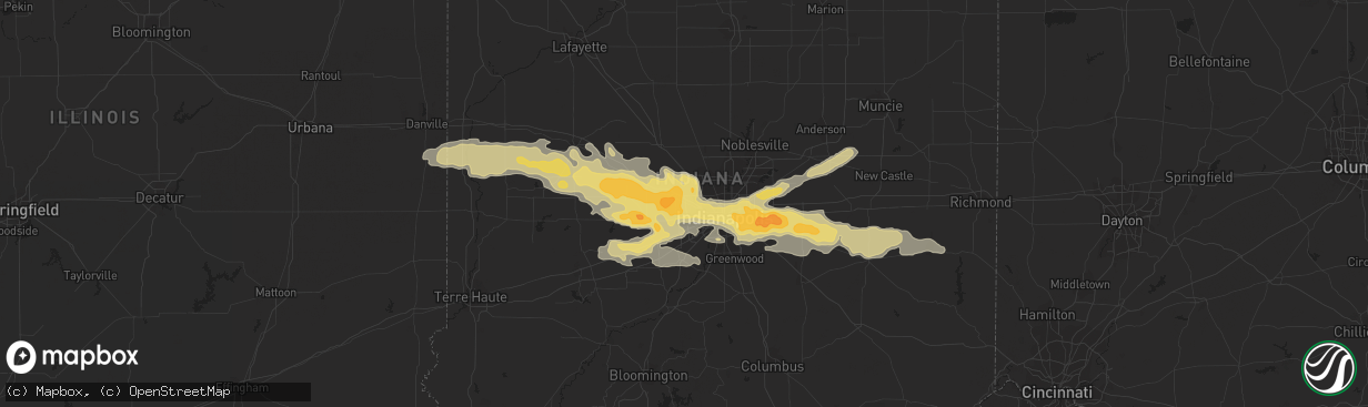
Hail
0
Estimated number of impacted properties by a 1.00" hail or larger0
Estimated number of impacted properties by a 1.75" hail or larger0
Estimated number of impacted properties by a 2.50" hail or largerStorm reports in Indianapolis, IN
Indianapolis, IN
| Date | Description |
|---|---|
| 09/21/20126:40 PM CDT | A local report indicates 1.00 inch wind near CUMBERLAND |
| 09/21/20126:40 PM CDT | Quarter size hail reported just west of cumberland. |
| 09/21/20126:36 PM CDT | Hail covering the ground. |
| 09/21/20126:36 PM CDT | Golf ball hail reported at franklin rd and raymond st. |
| 09/21/20126:35 PM CDT | Quarter sized hail reported at 10th st and arlington ave. |
| 09/21/20126:26 PM CDT | Power is out. |
| 09/21/20126:24 PM CDT | Half dollar size hail reported at lynhurst and rockville rd. |
| 09/21/20126:20 PM CDT | Reported at the rtv6 studio. |
| 09/21/20126:18 PM CDT | A local report indicates 1.00 inch wind near 7 W INDIANAPOLIS |
| 09/21/20126:15 PM CDT | Estimated 60 mph wind gusts accompanied by nickel sized hail at 21st street and raceway rd. |
All Cities Impacted by Hail Map on September 21, 2012
- Fountaintown, IN
- Shelbyville, IN
- Mount Pulaski, IL
- Charleston, IL
- Lerna, IL
- Pittsboro, IN
- Brownsburg, IN
- Danville, IN
- Shirley, IN
- Gwynneville, IN
- Kingman, IN
- Danville, IL
- Westville, IL
- Whitestown, IN
- North Salem, IN
- Wilkinson, IN
- Fairland, IN
- Waveland, IN
- Arlington, IN
- Georgetown, IL
- New Palestine, IN
- Waynetown, IN
- Veedersburg, IN
- Roachdale, IN
- Perrysville, IN
- Darlington, IN
- Amo, IN
- Jamestown, IN
- Crawfordsville, IN
- Cayuga, IN
- Carthage, IN
- Lebanon, IN
- Bainbridge, IN
- Clayton, IN
- Coatesville, IN
- Covington, IN
- Connersville, IN
- Plainfield, IN
- Alamo, IN
- Monrovia, IN
- Lizton, IN
- Greencastle, IN
- Stilesville, IN
- Zionsville, IN
- New Ross, IN
- New Market, IN
- Beech Grove, IN
- Hillsboro, IN
- Ladoga, IN
- Markleville, IN
- Bloomingdale, IN
- Russellville, IN
- Rushville, IN
- Middletown, IN
- Falmouth, IN
- Fortville, IN
- Glenwood, IN
- Fillmore, IN
- Indianapolis, IN
- Morristown, IN
- Marshall, IN
- Avon, IN
- Camby, IN
- Pendleton, IN
- Mooresville, IN
- Greenfield, IN
- Mccordsville, IN
- Cisco, IL
- Maroa, IL
- Warrensburg, IL
- Argenta, IL
- Latham, IL
- Chestnut, IL
- Homer, IL
- San Jose, IL
- Athens, IL
- Williamsville, IL
- Dousman, WI
- North Prairie, WI
- Oconomowoc, WI
- Wales, WI
- Mukwonago, WI
- Waukesha, WI
- Mason City, IL
- Petersburg, IL
- Sherman, IL
- Eustis, FL
- Debary, FL
- Arcola, IL
- Humboldt, IL
- Elkhart, IL
- Villa Grove, IL
- Newman, IL
- Camargo, IL
- Oakland, IL
- Hindsboro, IL
- Carlinville, IL
- Emden, IL
- Mahomet, IL
- Mansfield, IL
- Boggstown, IN
- Needham, IN
- Thorntown, IN
- Cantrall, IL
- Mattoon, IL
- Decatur, IL
- Forsyth, IL
- Dayton, OH
- Manilla, IN
- Easton, IL
- Forest City, IL
- Helenville, WI
- Sullivan, WI
- Sidney, IL
- Philo, IL
- Savoy, IL
- Tolono, IL
- Champaign, IL
- Delafield, WI
- Galesburg, IL
- Martinsville, IL
- Advance, IN
- Dewey, IL
- Riverton, IL
- Buffalo, IL
- Cambridge, WI
- Deerfield, WI
- Tuscola, IL
- Atwood, IL
- Rockville, IN
- Sadorus, IL
- Urbana, IL
- Ivesdale, IL
- Waunakee, WI
- Middleton, WI
- Trilla, IL
- Greenup, IL
- Casey, IL
- Kampsville, IL
- Greenview, IL
- Clay City, IN
- Monticello, IL
- White Heath, IL
- New Castle, IN
- Liberty, IN
- Brownsville, IN
- Madison, WI
- Westfield, IL
- Cottage Grove, WI
- Whiteland, IN
- Franklin, IN
- Lake Mills, WI


