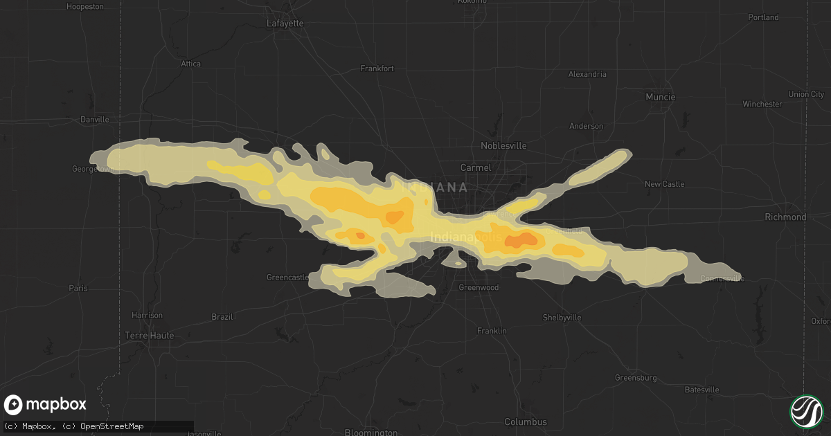
Hail Map in Brownsburg, IN on September 21, 2012
Get this storm
September 21 map
$229
one time, instant access
Download today. No call, no setup
Keep the $229
Bought the map and want the full workflow? Apply the entire $229 to a subscription within 7 days. None of it is wasted.
Every map, not just this one
This buys you this map. Subscription and you get every map we run, in the markets you choose from a few cities to whole states to nationwide. Plus real-time alerts the moment a storm fires.
Contact data
Name, contact info, occupancy, even credit band for addresses in the footprint. You go from where it hit to who to call.
Become the source they trust
Unlimited branding weather history reports on demand. You already have the documented answer ready for the property owner, and you are the one who showed up with it.
Property data and RoofTrace estimates
Pull up any address you have got, its value and the exact code rules for that jurisdiction, straight from One Click Code. Then RoofTrace estimates the squares, pitch, and roof value, priced the way you price.
Storm reports in Brownsburg, IN
Brownsburg, IN
| Date | Description |
|---|---|
| 09/21/20126:25 PM CDT | Time estimated based on radar and other reports in the area. |
| 09/21/20126:20 PM CDT | Siding and shingles blown off of a home. Patio furniture and a gazebo damaged at neighboring homes. Near state route 267 and tildon road just south of brownsburg. |
| 09/21/20126:15 PM CDT | A local report indicates 1.00 inch wind near 2 NNE BROWNSBURG |
| 09/21/20126:11 PM CDT | A local report indicates 60 MPH wind near BROWNSBURG |
| 09/21/20126:11 PM CDT | A local report indicates 1.50 inch wind near BROWNSBURG |
| 09/21/20126:07 PM CDT | A local report indicates 1.00 inch wind near BROWNSBURG |
All Cities Impacted by Hail Map on September 21, 2012
- Fountaintown, IN
- Shelbyville, IN
- Mount Pulaski, IL
- Charleston, IL
- Lerna, IL
- Pittsboro, IN
- Brownsburg, IN
- Danville, IN
- Shirley, IN
- Gwynneville, IN
- Kingman, IN
- Danville, IL
- Westville, IL
- Whitestown, IN
- North Salem, IN
- Wilkinson, IN
- Fairland, IN
- Waveland, IN
- Arlington, IN
- Georgetown, IL
- New Palestine, IN
- Waynetown, IN
- Veedersburg, IN
- Roachdale, IN
- Perrysville, IN
- Darlington, IN
- Amo, IN
- Jamestown, IN
- Crawfordsville, IN
- Cayuga, IN
- Carthage, IN
- Lebanon, IN
- Bainbridge, IN
- Clayton, IN
- Coatesville, IN
- Covington, IN
- Connersville, IN
- Plainfield, IN
- Alamo, IN
- Monrovia, IN
- Lizton, IN
- Greencastle, IN
- Stilesville, IN
- Zionsville, IN
- New Ross, IN
- New Market, IN
- Beech Grove, IN
- Hillsboro, IN
- Ladoga, IN
- Markleville, IN
- Bloomingdale, IN
- Russellville, IN
- Rushville, IN
- Middletown, IN
- Falmouth, IN
- Fortville, IN
- Glenwood, IN
- Fillmore, IN
- Indianapolis, IN
- Morristown, IN
- Marshall, IN
- Avon, IN
- Camby, IN
- Pendleton, IN
- Mooresville, IN
- Greenfield, IN
- Mccordsville, IN
- Cisco, IL
- Maroa, IL
- Warrensburg, IL
- Argenta, IL
- Latham, IL
- Chestnut, IL
- Homer, IL
- San Jose, IL
- Athens, IL
- Williamsville, IL
- Dousman, WI
- North Prairie, WI
- Oconomowoc, WI
- Wales, WI
- Mukwonago, WI
- Waukesha, WI
- Mason City, IL
- Petersburg, IL
- Sherman, IL
- Eustis, FL
- Debary, FL
- Arcola, IL
- Humboldt, IL
- Elkhart, IL
- Villa Grove, IL
- Newman, IL
- Camargo, IL
- Oakland, IL
- Hindsboro, IL
- Carlinville, IL
- Emden, IL
- Mahomet, IL
- Mansfield, IL
- Boggstown, IN
- Needham, IN
- Thorntown, IN
- Cantrall, IL
- Mattoon, IL
- Decatur, IL
- Forsyth, IL
- Dayton, OH
- Manilla, IN
- Easton, IL
- Forest City, IL
- Helenville, WI
- Sullivan, WI
- Sidney, IL
- Philo, IL
- Savoy, IL
- Tolono, IL
- Champaign, IL
- Delafield, WI
- Galesburg, IL
- Martinsville, IL
- Advance, IN
- Dewey, IL
- Riverton, IL
- Buffalo, IL
- Cambridge, WI
- Deerfield, WI
- Tuscola, IL
- Atwood, IL
- Rockville, IN
- Sadorus, IL
- Urbana, IL
- Ivesdale, IL
- Waunakee, WI
- Middleton, WI
- Trilla, IL
- Greenup, IL
- Casey, IL
- Kampsville, IL
- Greenview, IL
- Clay City, IN
- Monticello, IL
- White Heath, IL
- New Castle, IN
- Liberty, IN
- Brownsville, IN
- Madison, WI
- Westfield, IL
- Cottage Grove, WI
- Whiteland, IN
- Franklin, IN
- Lake Mills, WI


